Download Agreement, Release, and Acknowledgement of Risk:
You (the person requesting this file download) fully understand mountain climbing ("Activity") involves risks and dangers of serious bodily injury, including permanent disability, paralysis, and death ("Risks") and you fully accept and assume all such risks and all responsibility for losses, costs, and damages you incur as a result of your participation in this Activity.
You acknowledge that information in the file you have chosen to download may not be accurate and may contain errors. You agree to assume all risks when using this information and agree to release and discharge 14ers.com, 14ers Inc. and the author(s) of such information (collectively, the "Released Parties").
You hereby discharge the Released Parties from all damages, actions, claims and liabilities of any nature, specifically including, but not limited to, damages, actions, claims and liabilities arising from or related to the negligence of the Released Parties. You further agree to indemnify, hold harmless and defend 14ers.com, 14ers Inc. and each of the other Released Parties from and against any loss, damage, liability and expense, including costs and attorney fees, incurred by 14ers.com, 14ers Inc. or any of the other Released Parties as a result of you using information provided on the 14ers.com or 14ers Inc. websites.
You have read this agreement, fully understand its terms and intend it to be a complete and unconditional release of all liability to the greatest extent allowed by law and agree that if any portion of this agreement is held to be invalid the balance, notwithstanding, shall continue in full force and effect.
By clicking "OK" you agree to these terms. If you DO NOT agree, click "Cancel"...
Summit Elevation: 8,363'
Start Elevation: ~2,600'
Vertical Gain: ~5,700'
Vertical Skied: 5,700'
Round Trip Distance: ~9 mi.
Round Trip Time: 5:30
Red Tape: Permits are required. They are purchased on line and you can print them out. At the time I was ready to climb this peak, weekend permits were sold out, but weekday permits were in abundance.
Mount Saint Helens is not the steepest of the Cascade volcanoes, or most prominent, or highest, or challenging, or remote, or aesthetic, or iconic, or...where was I going with this? Oh, yes, I remember. It may not be any of those things I described above, but if you're a science/nature nerd like me, you've got to love this volcano!
The spectacular 1980 (my birth year) eruption, the pyroclastic flows, the massive destructive force of nature, the newly formed crater glacier that is growing as fast as the lava dome it covers. What's not to love about this mountain? Not to mention you can ski four thousand vertical feet of above-tree-line corn!
After skiing Mt. Hood on Sunday, I parted ways with my ski partner Natalie (SnowAlien) and told her to meet me at the Mt. Saint Helens trail head. After skiing two volcanoes in two states with her, I learned that giving her directions was just as pointless as asking her for directions. Every time I'd ask her for directions, she would say "google it," and every time I'd try to give her directions, she'd say "just give me the address so I can google it."
Not long after entering Washington, I lost phone service for good. Fortunately I had my map and made my way towards "climbers bivuoac." This is the main trailhead to climb the mountain on the south side. If you're familiar with the mountain, you will understand why people only approach from the south (the north side is gone). I figured I'd be able to get to this trailhead given that it is below four thousand feet elevation. When I noticed that snow level went down to two thousand feet elevation, I got a bit worried.
First glimpse on the way in
Sure enough, I couldn't get anywhere near the trail head. Another check of the map and I was able to locate the winter trail head at Marble Mountain Sno-Park, at 2,600' elevation. Although much lower than Mount Hood, it appeared that St. Helens would be the same vertical gain.
By the time I was ready for bed, I did a search around the parking lot, looking for my partner's car. It wasn't there. And I had no way of contacting her. So, either I'd see her in the morning or I would be going solo (not that anyone is really solo on such a popular mountain).
At 5:30 a.m. I was ready to hit the trail. I quickly scanned the parking lot and saw no sign of my partner. So, solo I would go.
The trail was immediately and continuously snow packed right from the parking lot. The snow was packed firm from probably thousands of winter and spring skiers. The trail was easy to follow to tree line. Tree line was around 4,000' elevation, which is about two thousand feet lower than tree line on Mount Adams, a few tens of miles to the east. I'm no expert, but I would guess it's due to the increased snow that St. Helens gets compared to Adams (the climate gets drier as you travel east, and eventually becomes desert in eastern Washington).
I made it to 4,000' in about an hour. This is tree line (at least on this portion of the mountain), above which nothing grows...except for sweet, sweet corn! From tree line, I just looked up the mountain and chose my preferred route (I imagine in the summer you must follow a specific path if you are off of snow).
Mt. Hood comes into view
Then Adams comes into view
I reached the summit by 10 a.m. (my anticipated time).
St. Helens is pretty rainy, but this peak is Rainier
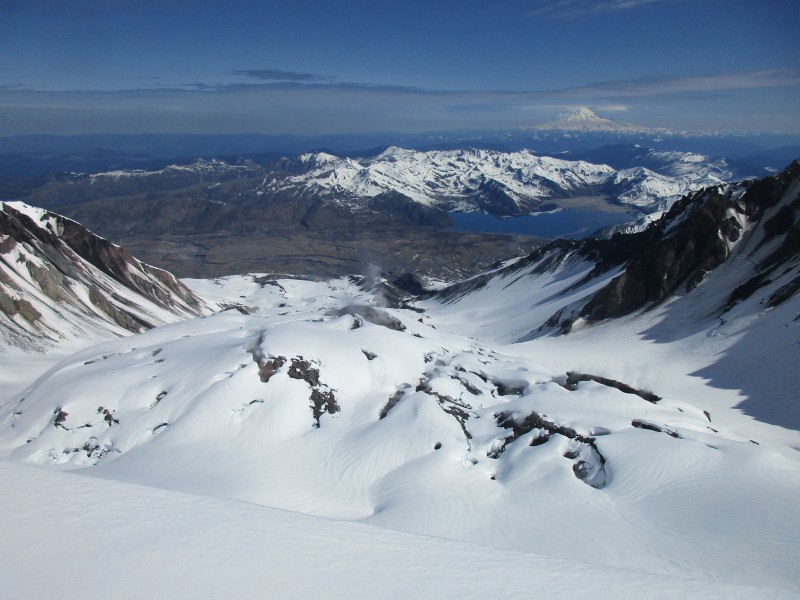
Being the nerd I am, getting to see the crater and lava dome was almost as much of a goal as skiing this mountain. I carefully inched my way to the crater rim, wary of getting too close and falling into the abyss. Fortunately, the rim was mostly free of overhanging cornices. I got the view I hoped for...
Glacier covered lava dome, steeming vents, a cool lake, and Mt. Rainier!
I enjoyed the views for a half hour then clicked in, prepared to harvest some quickly ripening corn.
I didn't take many pictures on the way up because I was expecting to take the best shots on the way down. Unfortunately, I was having way too much fun on the way down to stop and shoot. Fortunately, I had my Go Bro to tell the story.
Thanks Saint Helens!
Epilogue:
On my way down I saw Natalie climbing up. Although I've sent and received a few texts to/from her, I've never heard the story of what happened to her. She tells me she will write her own trip report, so I guess I'll find out soon enough. I wonder if I'm somehow to blame. Probably.
After getting back to town, I rechecked the weather forecast. The next day, Tuesday, was good weather and Wednesday was 20% showers. In Colorado, 20% means go time, but in the Cascades, I figured 20% could mean failure. Then real storms would arrive on Thursday and persist through the foreseeable future. With two more (side by side) peaks on my list, a hundred miles to the north, with each one requiring over nine thousand vertical feet of climbing, and no beta on whether I could get to my anticipated starting point, I decided it wasn't worth the drive up there. At best, I could get one of the peaks, but possibly none. Whereas, if I came back another time, I could probably get them both, back-to-back. So, I called it a vacation and headed home.
It was a long drive, so I did it in a few days, and stopped to enjoy the scenery and nature wherever I could find it. Here are a few wildlife pics I took in some beautifully unspoiled desert grasslands in eastern Oregon.
Pronghorn
Great Basin rattlesnake with large meal in his belly
Great Basin Whiptail lizard
Thumbnails for uploaded photos (click to open slideshow):
Wow, very nice vacation indeed! I've always wanted to do those two (St Helens & Hood). They are not that far away, although I would have to walk down, but nevertheless it would be a great experience! Nice pic of the Rattlesnake, I saw a monster snake in the GC last year at Rainbow Falls. Good to have zoom lens on the camera, yikes,it looks mean and nasty!
boudreaux: Great basin rattlesnakes are known for their placid nature. Even with all the harassment of our photo session, the little guy never attempted to strike. He just tried to get away, which made photographing him more difficult. The aggressive prairie rattlesnakes that live in eastern Colorado are much easier to photograph because they tend to stand their ground.
I'll just be weekend warrioring some 13ers around Colorado until the snow melts.
Caution: The information contained in this report may not be accurate and should not be the only resource used in preparation for your climb. Failure to have the necessary experience, physical conditioning, supplies or equipment can result in injury or death. 14ers.com and the author(s) of this report provide no warranties, either express or implied, that the information provided is accurate or reliable. By using the information provided, you agree to indemnify and hold harmless 14ers.com and the report author(s) with respect to any claims and demands against them, including any attorney fees and expenses. Please read the 14ers.com Safety and Disclaimer pages for more information.
Please respect private property: 14ers.com supports the rights of private landowners to determine how and by whom their land will be used. In Colorado, it is your responsibility to determine if land is private and to obtain the appropriate permission before entering the property.


 First glimpse on the way in")
")
 Mt. Hood comes into view")
 Then Adams comes into view")
 St. Helens is pretty rainy, but this peak is Rainier")
 Glacier covered lava dome, steeming vents, a cool lake, and Mt. Rainier!")
")
")
")
")
")
 Pronghorn")
 Great Basin rattlesnake with large meal in his belly")
")
 Great Basin Whiptail lizard")
")


