| Report Type | Full |
| Peak(s) |
Griffith Peak - 11060 |
| Date Posted | 04/19/2017 |
| Date Climbed | 04/15/2017 |
| Author | nyker |
| Griffith Peak in The Silver State |
|---|
|
I'd been wanting to climb Charleston Peak and Griffith Peak for years, but it just never worked. I had always planned to a do a route that would capture both summits in either a loop from the North or an out and back from the South. For reasons of economy, I always found myself in the region in mid-winter, so had made my attempts in Jan/Feb while I was there and unfortunately due to scheduling, I'd typically only have a single day to climb. As you might imagine, trying to fit in and properly time a long, challenging climb in winter conditions on a tight fixed inflexible schedule, planned months ahead of time, rarely works. Griffith Peak is the prominent snow capped mountain, rising up from the desert in the right of center of the photo below: 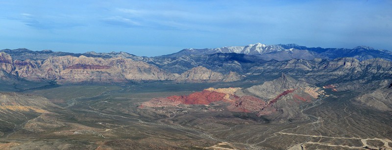 Anyone familiar with the Spring Mountains in Nevada knows how they can get dumped on with snow even well into April, despite the otherwise arid climate that surrounds them. I'd grow to learn this on successive trips and would begin to manage my expectations for success and road access. A day climb on these peaks in the winter was looking progressively more difficult with tight scheduling ①this past winter, I hadn't even bothered to attempt it as a recent storm put four more feet of snow on the ground before getting into town. After getting stymied twice in the past by major snowstorms that closed down roads, resulting in many additional miles of approach then postholing in snowshoes in waist deep snow moving blindly on a make-it-as-you-go-route, then two years later, a widespread fire closing down the south route leaving only the avalanche prone north route, I was on my fourth attempt to climb either of these mountains. I finally decided to come out here separately in Spring to focus on them, or at least one of them rather than trying to fit them in a free day gambling on conditions as I'd unsuccessfully tried in the past. It WAS mid-April, so I was planning on winter-like conditions, though hopefully with a bit more stable weather. The first day I planned to attempt a summit or at least do some reconnaissance on the route to see if I could actually figure it out in the snow; worse case I'd get some acclimatizing in since I'd be coming from sea level. The summer trail head was still closed, which meant parking down about a mile below at a lower trail head, then walking up to the trail head proper which makes the round trip to Griffith Peak a very doable 12 miles and roughly +4,000ft elevation gain. Starting elevation was approximately 7,300ft. (Note this was not the Griffith Peak Trail, which starts further east). The below shot shows the beginning of the trail, where there actually is a trail as it makes its way through the forest, half filled with burned pines from the recent fire.  It turned out that route finding was tricky and after a half mile walking in the now burned out forest, any visible trail disappeared and unmarked snow dominated the landscape. I didn't see footprints or signs anyone had been here in a while. This part of the National Forest had also just recently opened in the last week after being closed for several years due to a widespread fire and ensuing risk of falling trees, tree limbs, etc. so I wasn't sure what to expect with trail conditions/visibility, deadfall or downed trees along the trail. As it turned out, after that first half mile or so, there wasn't any identifiable trail to worry about. Map and compass in hand didn't really help other than vaguely pointing me in what I thought might be the correct direction. After a wrong turn or two that lead me to multiple dead ends, I found myself entering onto a snowfield that resembled a glacier running down into the valley from a steep multi-tiered ravine above. As I walked through it, it seemed more like a runout from recent avalanches, given all the broken trees and scattering of leaves and branches on top of and emerging from melted snow. Below is the start of the snow and the last of the trail fragment - the trail-looking section that veers left here is not the trail. Not sure where that heads off to but ended in a dead end after a 30 min walk up. 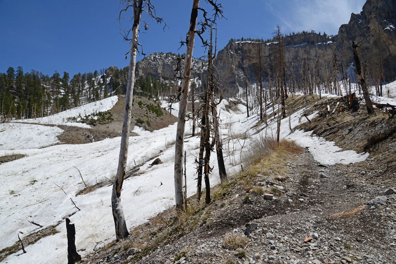 I thought I saw another trail fragment across and above the snowfield so I walked across and followed a faint trail up a hill, then aimed for a higher rock outcropping on the other side hoping for either an entry past the vertical rock walls that line the canyon floor or at least to gain a vantage point from which I could ascertain the actual route to Griffith. There were many trees and branches on the floor, obscuring any existing route and coupled with the snow, made finding any route akin to finding a needle in a haystack, so I just figured I'd make mental notes on the way and move landmark to landmark, marking a direction on my compass if the terrain became more complicated. Continuing to explore, after two more wrong turns and 90 minutes later, I was on top of the rocky perch, cliffed out on two sides, the wrong direction on the side I came and a long expanse to the southeast which led down to the floor and then up a distant peak. I figured downclimbing this and aiming southwest would give me a better shot at getting close to where I was aiming for, i.e. the route for the saddle for either summit, after which I could make my decision on which peak to go after if not both. To the west I saw a steep slope that looked like an older avalanche chute which seemed the only way to gain the upper reaches of the mountain.  The above shot shows the entire ravine which I opted to move up. Unfortunately, it took almost another hour to get to the bottom of that and at that point, I was realizing, it was getting too late to have a shot at climbing either peak today, so I figured I'd identify the route, or any route up see it in daylight, and then get comfortable that I'd be able to retrace it in dark in an alpine start the next morning. While steep and windy, it was pretty straightforward moving up, though I wouldn't want to be here after recent/fresh snow as it seemed to funnel debris and snow from the surrounding cliffs. The Climb The forecast was solid, and called for warmer weather and clear skies. Waiting paid off. Hitting the trail at 4:00AM, I figured that would allow me enough time to get to the steeper snow while it was still firm to make for better cramponing up and not too mushy for getting down. The below shot shows the break in the canyon walls just at sunrise, and was pretty much the only way through the rock guarding the upper mountain. 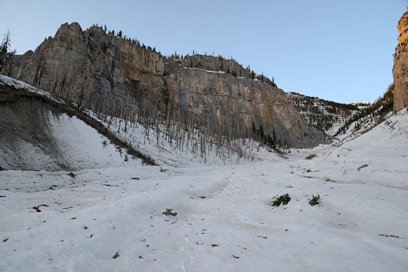 I completed the lower forested portion of the identifiable trail in the dark under light from my headlamp and by the time I got to the snowfield, it was light enough to moving up without a light, sunrise was 20 minutes away. Crampons went on once the slope started to increase, though I didn't feel I needed an axe yet. Slope was gentle, moving up to 20-25 degrees which given the firm snow needed traction (though wouldn't be needed on the descent later on as it warmed). A shot of the burned forest on a smaller peak east of Griffith:  There were three sections of this snowfield where the ravine turned, first left (south), then right (westerly) then south west again. With each turn it gained in steepness getting to around 40 degrees in spots, requiring me to get out my axe. 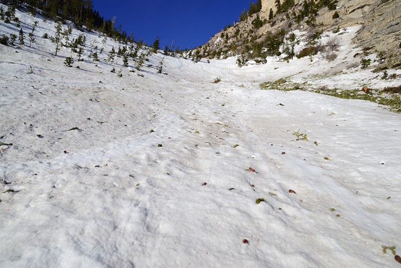 Pine cones would occasionally roll past me down the hill, gathering enough momentum to continue rolling well out of sight. Eerily reminded me of the rocks that rolled past on North Maroon Peak as I climbed up.   After steady rest stepping for an hour or so, I finally made it to the top of what I thought would be a ridge, but in reality turned out only to be another tier where an gently sloping open area appeared which then lead to a much steeper slope to what appeared to be another ridge.  At this altitude on the slope, the trees were all either bent over or twisted either from the harsh climate, recent avalanches or from being covered with heavy snow. Following much of the snow fall that the Sierras further west have seen this year, snowpack here was also above normal. The day before the Ranger in town said that current snow level was 180% last year which was itself a heavier snow year and I was told a recent storm a couple weeks ago put 3ft of snow lower down on the road at 7,000ft.   This area was stunning and was surrounded by a ridgeline on three sides, with the steep ravine behind all blanketed in white gently sloping upward with pattern lines on the snow outlining the landscape.  I took a break and pondered the surroundings and studied possible routes. I still saw no other footprints anywhere. While the terrain wasn't even, this would be a great place to camp if you could get a flatter place away from a slide path and brought your own water. Time to look for options. Straight up due west or northwest seemed rife with cliff bands, rock walls and steep unstable snow, with rocks tumbling down every few minutes. To climbers right (north/northwest) the terrain was equally unappealing with ground steep enough that snow wasn't sticking to it leading to cliff bands higher up. The only option seemed to the south/southwest where there was another twisting chute that I was hoping would be doable, so that's the way I headed up. The chute is left center in the photo below and starts off nice and gentle before steepening around the bend:  Mummy Mountain seen in the distance as the terrain angle steepens  The terrain here was gradual for the first quarter mile with a slope of maybe 25 degrees. It then turn up to 40-45 degrees in short order and kept this angle for maybe 500 more vertical feet. In spots it easily exceeded this depending on the direction and line you took to gain the ridge. 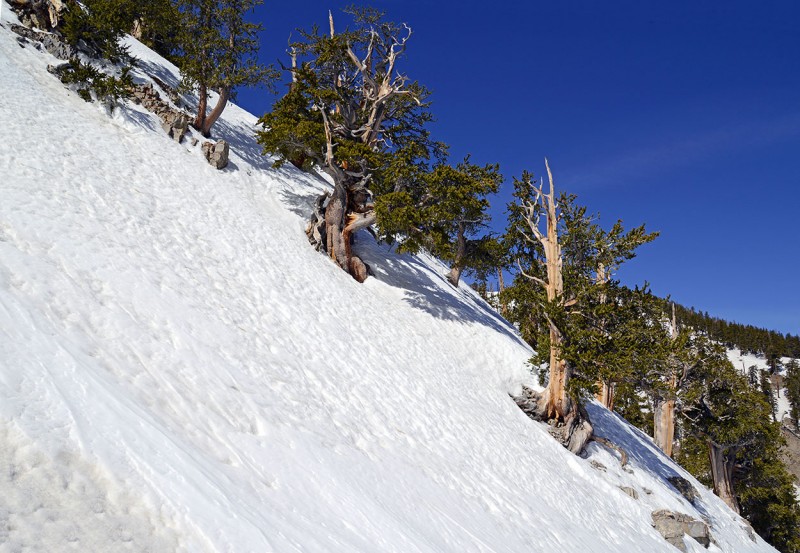 Looking closely you can see my tracks in the pic below, showing my wandering both trying to find a better route and also seeking a good perspective for a photo. The better route moves up to the far left up in the photo.  Looking up at two climbers further up the slope coming down (taken on the descent when the snow softened in the sun)  Trees were sparse at this point and what trees remained were gnarled and twisted ancient Bristlecone Pines, eking out a living in this harsh world. I love these trees, so unique and full of character and inherently full of history, many being over 2,000yrs old. The angle of the terrain was pretty steep so I didn't stop and take too many photos here...but had to get one or two as the gnarled trunks of the Bristlecones in snow against the blue sky looked pretty cool.  I had to be careful climbing in close proximity to any of the conifers, as spruce traps were prevalent around most trees. As I climbed higher up, the slope angle increased. Much of this climbing here was on all fours and I was regretting not bringing a shorter ice tool which comes in handy in spots like this as it does in the Adirondacks on the slides. As I climbed higher and the sun hit the slope, the snow was getting softer enabling each step to sink in a bit making the climbing seem a bit easier, despite the snow becoming more unstable and potential postholing. The climbing was testing my cardio and went on for another hour until my altimeter reached around 10,800ft. Looking back down into the upper basin with Mummy Mountain in the background again (as its named for a body in profile, it reminded me of Izta in Mexico from a distance).  Topping out this section was a relief, though I wasn't sure what to expect further on, and was hoping for a clean line to the summit, not another false summit or sub ridge. My elation felt upon getting onto the ridge was tempered by the fact that the peak was not where I was expecting it to be but was more to the right/northwest another quarter mile. Beautiful view of the surrounding terrain including Charleston Peak in the distance amid buried stunted trees on on upper reaches of Griffith's shoulder 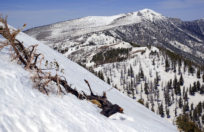 The surface of the snow formed a carpet of penitentes, resembling a combination of what I'd expect terrain on Mars to look like and the fur of a wet German Shepherd being out in the rain all day.  I moved slowly around the cornice guarding the ridge and the deeper snow behind it, being careful to steer clear from the edge, which felt unstable. I could also see broken remains of slabs that had slid down. There was a lot of deep snow up here  Topping out, I realized this was false summit, The false summit made me somewhat disenchanted though still excited that the summit was finally visible.  Continuing up above the false summit to the real summit was no more than a simple walk on gentle terrain, all the difficult sections were below the ridgeline. Blue bird skies in all directions. Great views all around.  Looking back east towards the desert 10,000ft below  Summit ammo can 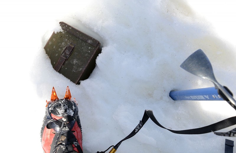 I finally summited Griffith Peak in the snow! For those in the area that are itching to get out into the mountains, I'd highly recommend doing Griffith Peak. I don't know what the hike is like in the summer, but can only imagine it's much more exciting, adventurous and picturesque in the Spring snow compared with a dry trail in summer heat. The distant Charleston Peak in the snow, remains my white whale, for now⦠Watch out for wild donkeys on the ride out 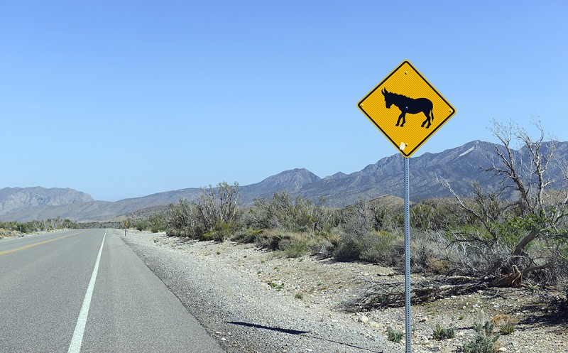 *************** Thumbnails for uploaded photos (click to open slideshow):
|
| Comments or Questions | |||||||||
|---|---|---|---|---|---|---|---|---|---|
|
Caution: The information contained in this report may not be accurate and should not be the only resource used in preparation for your climb. Failure to have the necessary experience, physical conditioning, supplies or equipment can result in injury or death. 14ers.com and the author(s) of this report provide no warranties, either express or implied, that the information provided is accurate or reliable. By using the information provided, you agree to indemnify and hold harmless 14ers.com and the report author(s) with respect to any claims and demands against them, including any attorney fees and expenses. Please read the 14ers.com Safety and Disclaimer pages for more information.
Please respect private property: 14ers.com supports the rights of private landowners to determine how and by whom their land will be used. In Colorado, it is your responsibility to determine if land is private and to obtain the appropriate permission before entering the property.


