Download Agreement, Release, and Acknowledgement of Risk:
You (the person requesting this file download) fully understand mountain climbing ("Activity") involves risks and dangers of serious bodily injury, including permanent disability, paralysis, and death ("Risks") and you fully accept and assume all such risks and all responsibility for losses, costs, and damages you incur as a result of your participation in this Activity.
You acknowledge that information in the file you have chosen to download may not be accurate and may contain errors. You agree to assume all risks when using this information and agree to release and discharge 14ers.com, 14ers Inc. and the author(s) of such information (collectively, the "Released Parties").
You hereby discharge the Released Parties from all damages, actions, claims and liabilities of any nature, specifically including, but not limited to, damages, actions, claims and liabilities arising from or related to the negligence of the Released Parties. You further agree to indemnify, hold harmless and defend 14ers.com, 14ers Inc. and each of the other Released Parties from and against any loss, damage, liability and expense, including costs and attorney fees, incurred by 14ers.com, 14ers Inc. or any of the other Released Parties as a result of you using information provided on the 14ers.com or 14ers Inc. websites.
You have read this agreement, fully understand its terms and intend it to be a complete and unconditional release of all liability to the greatest extent allowed by law and agree that if any portion of this agreement is held to be invalid the balance, notwithstanding, shall continue in full force and effect.
By clicking "OK" you agree to these terms. If you DO NOT agree, click "Cancel"...
Baldy Chato & Stewart Peak
Time...6am - 5pm
Distance...19.1 miles
Elevation Gain...5746 feet
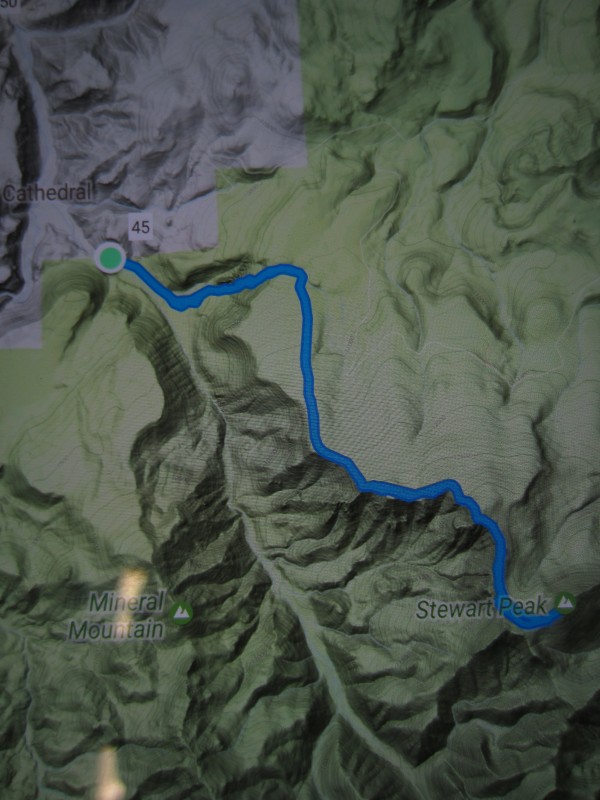
Starting Location...intersection of county roads 45 (788?) and 52, 1.25 miles SE of Cathedral
Route...Spring Creek to Cathedral Creek to NW Ridge
I had to give a nod to Sarah's report from last year on San Luis so I plagiarized her tr name... https://www.14ers.com/php14ers/tripreport.php?trip=16768
Without reading that report I never would have thought this route was possible. Who would have guessed that a "town" with a population of 14, in the middle of nowhere would be accessible in winter. Not only that, but the road to get there is one of the nicest dirt roads I've ever driven.
Getting There:
-turn south on 149 west of gunnison
-drive 17 miles south to powderhorn
-turn left onto county road 27/50
-drive 15 miles on a smooth dirt road to cathedral...this road is plowed in winter and is muddy in spots when it warms up
-turn left onto county road 788/52/45
-drive 1.25 miles to the intersection of a private ranch road (52) and Pinos Pass Road (45/788) and park here
That was the easy part. The hard part was getting permission from the land owner to walk through their property. I arrived at their gate at 9:30pm and didn't want to bother them that late. I started to drive up the Pinos Pass Road to see if I could find away around the east side of their property, but the snow got deep fast and I had to turn around. As soon as I turned around, a huge spot light hit me in the face. Uh oh. I tried to wave and say hello, but it was too far away. I drove down the road and the light followed me. Not good. When I got back down, I parked and thought about my next move. A few minutes later, a large pickup truck blasted out of the private property and fired passed me without even slowing down. It felt like a warning shot. Shit...this is bad. Luckily, it turned out my paranoia was for nothing. A few minutes later the truck came back and this time I was able to wave it down. The driver's name was Jeremy and he was great. I told him about my plans, he went and talked to his Dad and they gave me permission to walk through their property the next morning. On my way out the next day, I ran into another family member (Jeremy's Aunt?) who schooled me on the history of the ranch, remembered meeting Sarah and Dom last year and told me that next time I could drive all the way in and park in their driveway. So my advice to anyone else wanting to take this approach would be to get there in the daylight hours and go talk to the property owners. Besides a free-range cattle operation they also have a few cabins for rent and I'm sure they are more comfortable than the back of a vehicle.
This route is pretty straight forward...
-walk through the ranch...watch for barbed wire fences, I had to climb over a couple short ones
-climb up a small buttress in the middle of the bottom of Cathedral Creek...to avoid ranch buildings on either side
-make your way up the right side of Cathedral Creek...mix of open fields, tight trees and talus
-climb right out of cathedral creek
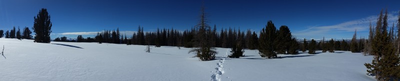
-hike through what feels like an endless stretch of trees
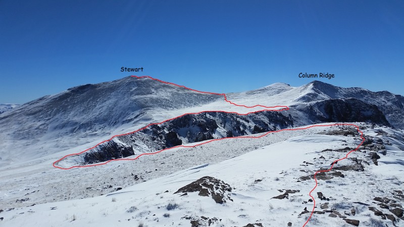
-continue along the ridge for a long time to the summit of Stewart
-turn around and retrace your steps...try not to think how far you have to go
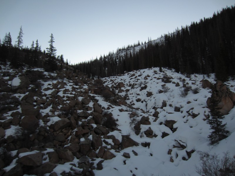
Boulder field in Cathedral Creek
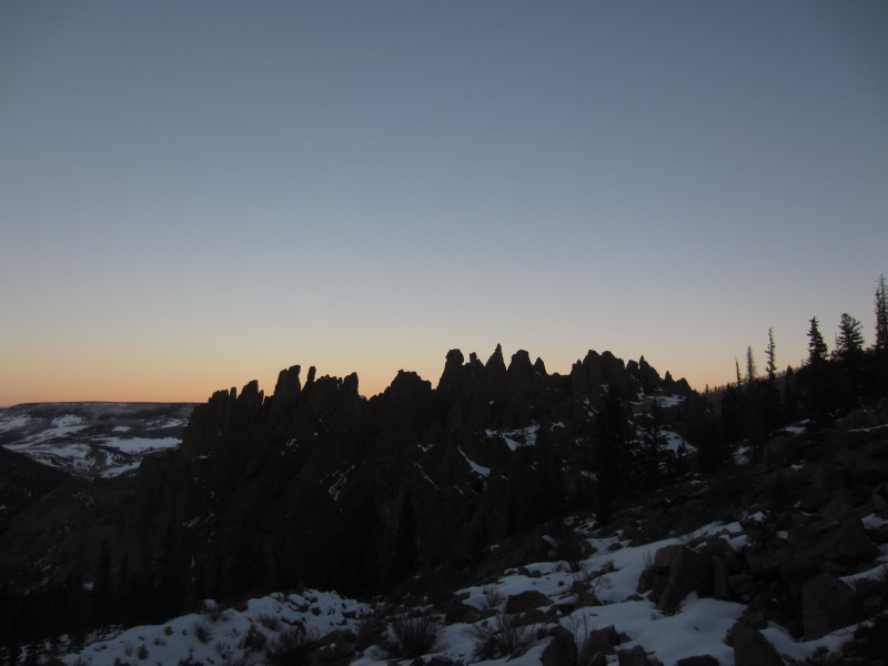
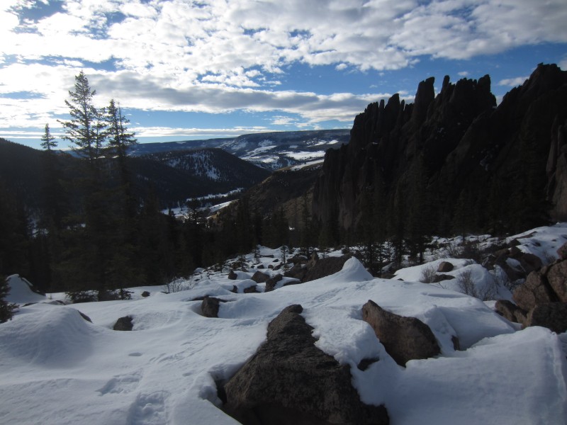
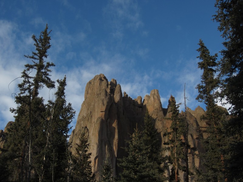
Cathedral Creek Hoodoos
Leaving the creek and heading into the trees
The elevation at the top of the creek was about 10,500'. Up to that point, the trail-breaking wasn't too bad and I was happy to only have 1500' to treeline. The problem with this ridge is that it is very low angle and those 1500' drag on forever. The trail-breaking in here was brutal and I was near tears when I finally broke out of the trees.
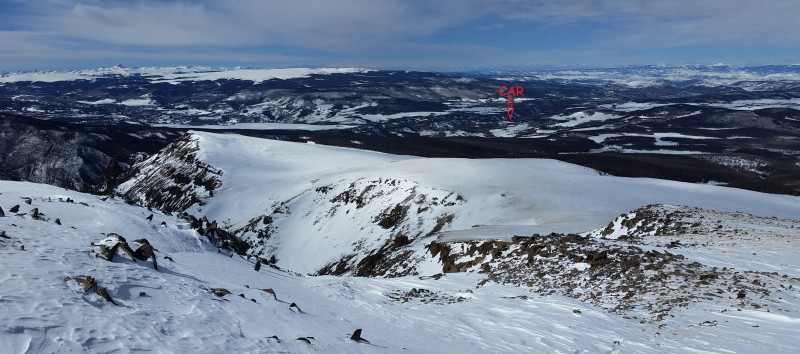
Looking up at the ridge with Spring Creek Valley to the right
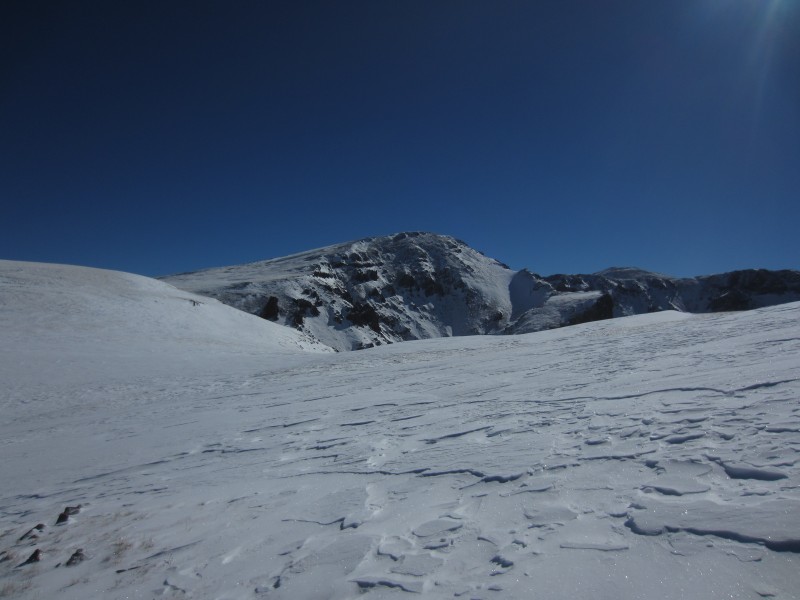
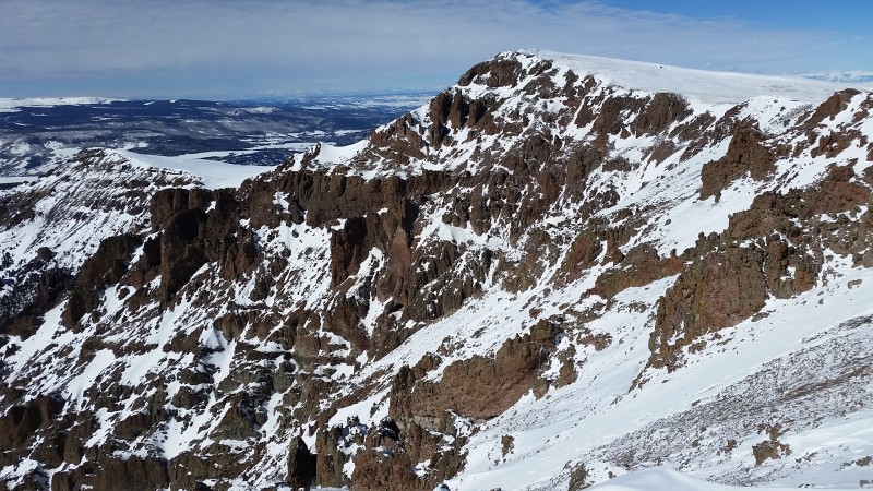
After a couple bumps, Baldy Chato comes into view.
Route to Stewart from Baldy Chato
Stewart might be the least attractive centennial peak, but what it lacks in appearance, it makes up for in remoteness. You have to work hard for this snowflake. I really wanted to relax and enjoy the hard-earned views from the summit, but the wind was picking up and I got cold fast.
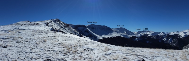
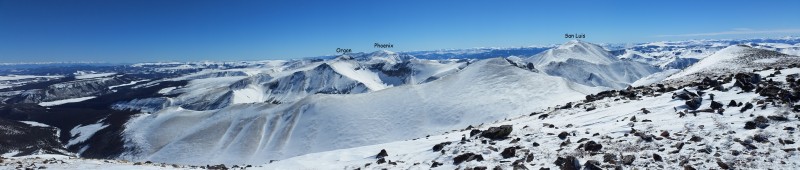
La Garitas from the summit of Stewart
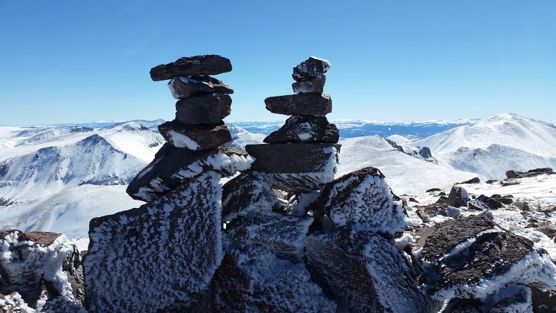
Brooke & Ben cairns
I pretty much retraced my steps on the way back, re-summiting Baldy Chato on the way. You can avoid some elevation gain by skirting high points on the east, but then you would risk having to take snowshoes on and off.
South side of Baldy Chato
Looking down on the ridge with Uncompahgre and Wetterhorn in the distance
Back into the trees for more snowshoe torture
Cathedral Creek
Spring Creek and the ranch...the rock buttress is just out of the picture on the right. I tried to be as inconspicuous as possible, but at some point you just have to get down in there with the cows and slop around in the dung.
I got back to my vehicle a little after 5pm and took this picture of Spring Creek and San Luis on the drive back towards Cathedral.
Strava map
Thumbnails for uploaded photos (click to open slideshow):
Don't see many winter trip reports from this area. 19 miles in winter would be brutal for a lot of us, but you crushed it! Keep posting these reports, like Jay, I also enjoy them!
Looks like a bit more snow on the peaks since we were on San Luis a few weeks ago. Your comment about remoteness of Stewart is spot on. It was one of the cruxes, if not the crux of the project for Centennial skiers as well and ended up being 30 mile RT for them. They did in in full Grand Traverse mode, i.e. ultralight. Congrats!
1.7 mph breaking trail in snow shoes, you're slipping...now your only twice as fast as the rest of us! I'm guessing you channeled your alter-ego Mad Mike to bust through treeline.
Keep cruising and keep sharing, you're an inspiration!
Druggie: [drugged, seeing the food alive] Mr. Sausage, when will it end?!
Beer Can: When will it end? When he stops drinking us!
Krinkler's Chips, Sandwich, Pop Tart, Tickilish Licorice: Yeah!
Cookies: And stops eating us!
Sandwich: Same here!
Pop Tart: Eff yeah!
Toilet Paper: And when he stops using us!
Krinkler's Chips: What did they do to you?
Toilet Paper: [nervously backs away] You don't wanna effin' know!
We are the druggies, the snow is the beer can, chips, cookies, sandwiches and pop tarts are our tools and the toilet paper is one of those things that we've learned to improvise if without. Wish I could be there, stomping the miles, cursing the snow and sharing summits. Alpinism is hours and hours of why, why, why followed by brief moments of, ah this is why. As always,thank you for sharing your moments of why.
Hilarious. Is that a direct quote from Sausage Fest or did you make that up?
Caution: The information contained in this report may not be accurate and should not be the only resource used in preparation for your climb. Failure to have the necessary experience, physical conditioning, supplies or equipment can result in injury or death. 14ers.com and the author(s) of this report provide no warranties, either express or implied, that the information provided is accurate or reliable. By using the information provided, you agree to indemnify and hold harmless 14ers.com and the report author(s) with respect to any claims and demands against them, including any attorney fees and expenses. Please read the 14ers.com Safety and Disclaimer pages for more information.
Please respect private property: 14ers.com supports the rights of private landowners to determine how and by whom their land will be used. In Colorado, it is your responsibility to determine if land is private and to obtain the appropriate permission before entering the property.


")


