Download Agreement, Release, and Acknowledgement of Risk:
You (the person requesting this file download) fully understand mountain climbing ("Activity") involves risks and dangers of serious bodily injury, including permanent disability, paralysis, and death ("Risks") and you fully accept and assume all such risks and all responsibility for losses, costs, and damages you incur as a result of your participation in this Activity.
You acknowledge that information in the file you have chosen to download may not be accurate and may contain errors. You agree to assume all risks when using this information and agree to release and discharge 14ers.com, 14ers Inc. and the author(s) of such information (collectively, the "Released Parties").
You hereby discharge the Released Parties from all damages, actions, claims and liabilities of any nature, specifically including, but not limited to, damages, actions, claims and liabilities arising from or related to the negligence of the Released Parties. You further agree to indemnify, hold harmless and defend 14ers.com, 14ers Inc. and each of the other Released Parties from and against any loss, damage, liability and expense, including costs and attorney fees, incurred by 14ers.com, 14ers Inc. or any of the other Released Parties as a result of you using information provided on the 14ers.com or 14ers Inc. websites.
You have read this agreement, fully understand its terms and intend it to be a complete and unconditional release of all liability to the greatest extent allowed by law and agree that if any portion of this agreement is held to be invalid the balance, notwithstanding, shall continue in full force and effect.
By clicking "OK" you agree to these terms. If you DO NOT agree, click "Cancel"...
Wilson Peak
February 4, 2017
+/- 10 miles RT, 5200' gain
From Rock of Ages TH
Participants: Jomah Fangonilo, Ryan Marsters, Danny Gilbert
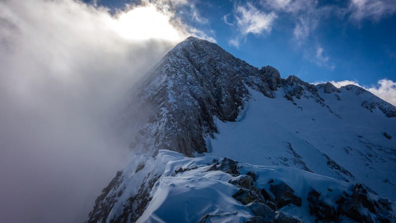
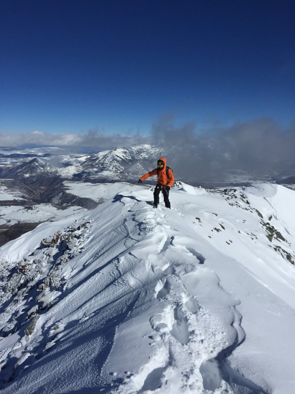
The Money Shot (JF)
The Most Beautiful Girl (In the Room)
The two main options for approaching Wilson Pk. are to come in from the South via Lizard Head pass, or to come in from the North via Rock of Ages. The stats are pretty similar from either side, but the South approach has been much more popular in recent years. Search for Winter trip reports on this site, and you will see that only Gladbach came in from the North and wrote about it.
Last year, about this time, Nate (TheGreatCamillo) and I headed to the RoA trailhead to take a crack at Wilson Peak. We opted for that approach because as mentioned above, the stats are similar but the North side is almost all on a road. We figured we could probably ski out, without dealing with a pesky re-ascent of LH pass. Also Gladbach did it that way ~ that's worth points to me.
We followed some skin tracks to the first junction, which I assumed at the time were from locals. I found out this weekend that it was actually Jomah and a partner on their way up to El Diente. Small world. Nate and I split from Jomah's tracks at the junction and headed for the standard route toward RoA. Long story short, we came as close as I ever care to come to being swept by an avalanche. I'll say only that we tried some other options, but this way was a dead end. We tucked tail and returned to the car. The one saving grace from the whole trip, was that I saw the silver pick basin in it's entirety, and it looked astoundingly safe. Every single avalanche slope had a reasonable bypass.
Approach Route Map (RM)
Dead End (RM)
Fast forward about a year, and I'm looking for partners to head up there again, this time by avoiding the "dead end" Nate and I discovered the year prior. I sent Ryan and a few others an email with a topo showing some options, Option A being the NW ridge. I didn't know anything about the ridge but on a map it is easily the most obvious line to the summit. Ryan countered with some beta he found on Summit Post which described the ridge as mostly class 4, with some low class 5 when staying ridge proper. No information around about this route having ever been done in winter. It was decided.
That's Why They Call it Business Socks
An early departure from work, and a minor snafu at Ryan's involving copious amounts of dog diarrhea and we're on our way west around 2:30 or so. Ryan informs me Jomah might come too, and would meet us at the trail head. Cool. I had met Jomah last year on Pyramid, he's solid and having a minority along was a comforting notion with things being as they are these days. Enter politically charged hashtag here: _______ . A pretty mundane drive, and we're all asleep in the back of our rides by 10ish. Not bad.
The alarm goes off at 3:30 and we're moving by around 4:15. Jomah on skis and Ryan and I on snowshoes. I marvel at Jomah's efficiency on the skis as we trudge up the road. I think I could match his pace, but I can see from his steps I would be redlining it if I tried. He settled into a conversational pace, if a little slower to keep from dropping us. This is the only time all day that I thought skis were smart.
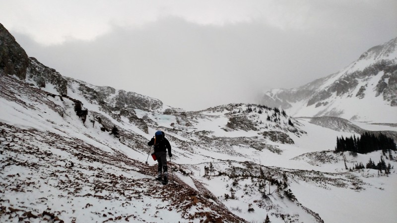
We wander up to an avy slope as we approach treeline. Jomah goes first, and at a reasonably safe place starts to dig down and look at the snow layers. I meander up to inspect this witchcraft and wonder if he is able to glean anything useful from the runes. Who knows? Unwilling to risk it, we backtrack and descend further into the basin to the next road down. That's the closest we come all day to avalanche terrain and we avoid it completely and with relative ease, like rock stars.
Through the trees and the basin takes shape with daylight. Much as I saw the year prior, this drainage is blown pretty clean of snow. Even this year, at something like 150% of our average snowpack you can see talus pathways all around. Talus gets broken by steep hard snow, and snowshoes are starting to outshine skis for the first time. Jomah ditches his sticks at the first section of talus. Ryan and I continued to the base of the ridge in snowshoes, while Jomah throws crampons over his ski boots.
Silverpick (RM)
Up and over a few contour lines we go. Ryan spies a chunk of ice and probably comments about how he could totally climb it or something. At the base of the ridge we ditch our snowshoes and poles. It's about a mile to the summit now, and a pretty straight shot.
Start of the Ridge (RM)
My shutterbug companions begin a routine of claiming that they just got the best picture of the day, and then repeating themselves only minutes later. I don't blame them, the views are unbelievable.
Ryan and I (JF)
Leggy Blonde
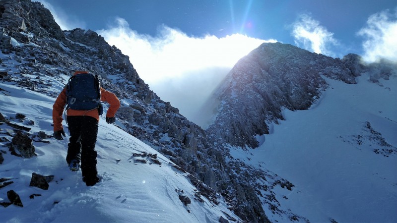
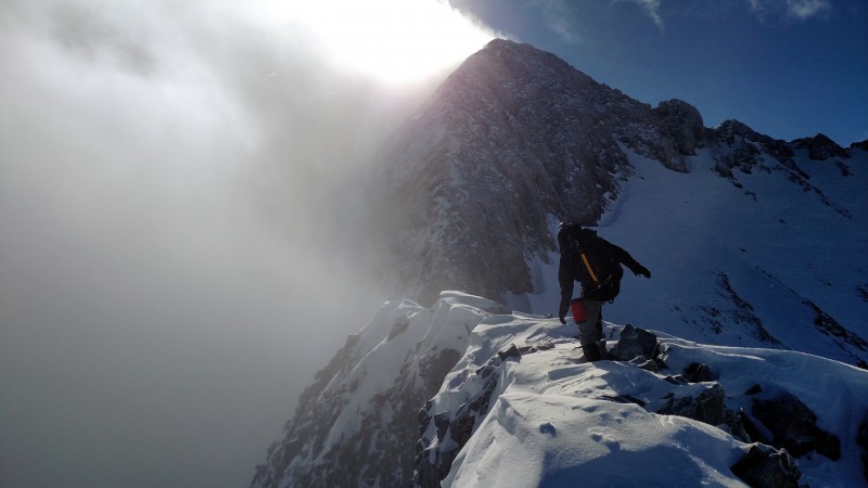
The ridge is best described in two parts. Part one, mostly heading East-West is probably class 2-3. A bit "gendarme-y" we opted to try our best to stay ridge proper, and had good success summiting every minor point along the way. This was aesthetic, but also the most obvious way through every time. Route finding was not an issue.
Early on the Ridge (JF)
(JF)
Group Photo (RM)
Jomah heading up (RM)
Fashion is Danger
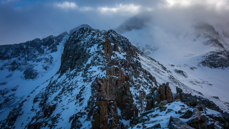
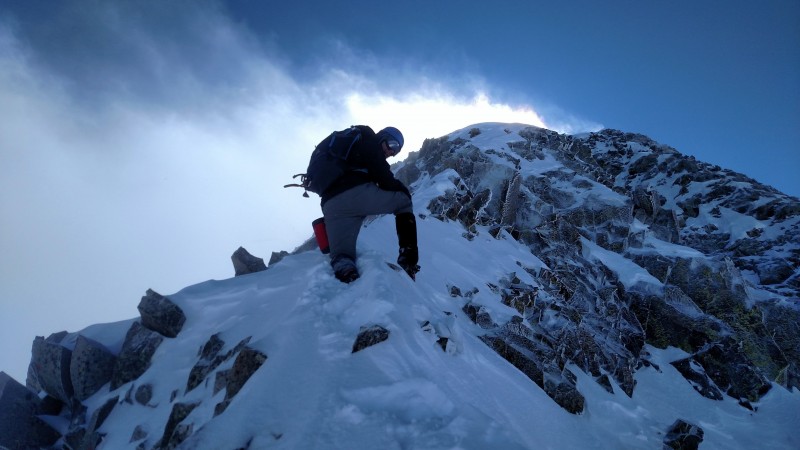
The second part of the ridge runs North-South and is probably class 3-4. The two parts are separated by a large notch, and the only real imperfection on this section of the ridge which is otherwise a very straight line. With no information available on a winter ascent, and some talk of class 5 sections we opted to carry a rope and light(er than the rope) rack. We stayed ridge proper all day, and although it was pretty sustained, and fairly loose none of us thought it was class 5. The rope and rack stayed in the pack, training weight I guess.
Me heading to the Notch (RM)
Jomah previewing some exposure (RM)
Ryan cruising some ridge, sideways for some reason
One of the steeper parts prior to the Notch
Route Map 1
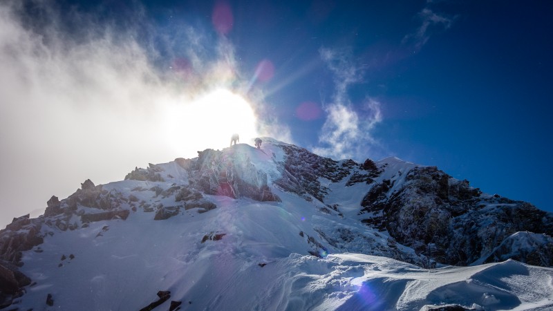
Nice shot of the upper end of the Ridge (RM)
Jomah (RM)
Last stretch (RM)
Ryan and I (JF)
Jomah (RM)
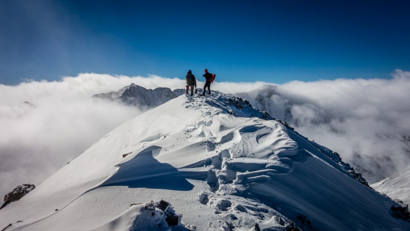
On the summit, the wind calmed to a complete stop. The sun shone, and the clouds buffered around the surrounding peaks. Views like those don't come around too often and we drank them in.
Ryan and I on the summit (JF)
(JF)
Ryan topping out
Jomah on top, sideways I guess...
(RM)
Lizard Head (RM)
Cheez-in it (JF)
Discussing various descent options we decided to try dropping into the basin at the first opportunity. On the way down though, with the sun in full force we called an audible. Nobody wanted anything to do with trying to post hole back to the snowshoe stash. Ridge proper we stayed again, all the way back down. Now and again we all took turns knocking stones down. Careful timing and patience were key and although some man-killers got let loose nobody was hurt. One spot in particular took some care because the whole section of ridge felt precariously balanced especially in the heat.
With some reflection, I can't think of a particularly good reason that this route isn't the standard way to do Wilson in the winter. It blows my mind that I can't find anything on it having been done in winter before. Yeah, maybe it is a little more exposed than the other options but we completely avoided avalanche terrain. That's a no-brainer if you ask me.
(RM)
Ryan also created a mountain project page for the route, for those interested: Wilson NW Ridge
Thumbnails for uploaded photos (click to open slideshow):
I learned two things: 1) it is good to have Jomah along on Denali in case any political complications ensue, and 2) check all available beer cans for beta on a route before asking for help. One thing I already knew is it's hard to keep up with Jomah when he's in front on his skis. Nice job fellas. Well done.
Nice job and great pics!
BTW, the non-rotated photos are uploaded that way because that's how they are actually stored on your computer. Using the "My Trip Reports" page, look for the "Rotate Pics" icon to the right of the trip report. That option will allow you to rotate individual pictures so they show up properly in the report. Once you do this, you'll have to refresh/reload your report when viewing, to update the browser image cache. If it appears that the rotation didn't take, don't do it again, it's probably just browser cache which needs to be reloaded.
If they still look messed up after rotation and browser refresh, clear your browser cache and they should look better.
I'm assuming the titles are musical references. As such, I don't understand them. Fun ridgeline - it is nice not to worry about avalanches every once in awhile.
Well done, white boys and Jomah. Spectacular pictures and scrambling all around. Some of the best winter pics with low lying clouds I have seen. How special to have been there in person.
Gilbert, can I borrow your calculator? Mine ran out of coal. Or was it steam. Dude, write more TR's. And these pictures. That ridge looks incredible. Oh and I don't have HBO. You don't need HBO for Ol Dirty Bastard and T Swift.
Ryan, I haven't seen you since 2015 and jokes about time stamps stopped being cool in 2012, so I've got nothing of any importance to say to you. I do still owe you 18 waters though.
Most good things occured in the 80's 2/8/2017 8:48am
Walk on ridge, hmmm?
Walk left side, unsafe. Walk right side, unsafe.
Walk anywhere other than the middle, sooner or later get squish just like grape.
Here, new NW ridge, same thing.
Either you choose ridge proper "yes" or perhaps "no."
But if you go ridge proper "guess so," squish just like grape. Understand?
Name that above movie. I may have made some stuff up.
Also, I think there's something missing in picture #8.
Musical reference: Flight of the Conchords. You wouldn't have gotten it even if it were the Beatles, Ryan.
Bill - thanks for the help with the pictures. Glad you liked the report.
Amy - you are the karate kid, and something is missing from the group shot.
Sarnelli - you are the king of inside jokes.
Jomah - Snowshoes > Skis in winter.
Way to crush! Did you see the Coors Light miners up there?
Caution: The information contained in this report may not be accurate and should not be the only resource used in preparation for your climb. Failure to have the necessary experience, physical conditioning, supplies or equipment can result in injury or death. 14ers.com and the author(s) of this report provide no warranties, either express or implied, that the information provided is accurate or reliable. By using the information provided, you agree to indemnify and hold harmless 14ers.com and the report author(s) with respect to any claims and demands against them, including any attorney fees and expenses. Please read the 14ers.com Safety and Disclaimer pages for more information.
Please respect private property: 14ers.com supports the rights of private landowners to determine how and by whom their land will be used. In Colorado, it is your responsibility to determine if land is private and to obtain the appropriate permission before entering the property.


 Dead End (RM)")
 Silverpick (RM)")
 Start of the Ridge (RM)")
 Early on the Ridge (JF)")
 Ryan and I (JF)")
 (JF)")
 Group Photo (RM)")
 Jomah heading up (RM)")
 Me heading to the Notch (RM)")
 Jomah previewing some exposure (RM)")
 Ryan cruising some ridge, sideways for some reason")
 One of the steeper parts prior to the Notch")
 Nice shot of the upper end of the Ridge (RM)")
 Jomah (RM)")
 Last stretch (RM)")
 Ryan and I (JF)")
 Jomah (RM)")
 Ryan and I on the summit (JF)")
 (JF)")
")
 Ryan topping out")
 Jomah on top, sideways I guess...")
 (RM)")
 Lizard Head (RM)")
 Cheez-in it (JF)")
 Route Map 1")
 (RM)")
 The Money Shot (JF)")
 Approach Route Map (RM)")


