| Report Type | Full |
| Peak(s) |
Mt. Princeton - 14,200 feet |
| Date Posted | 01/07/2017 |
| Modified | 12/08/2017 |
| Date Climbed | 08/30/2016 |
| Author | DeTour |
| Additional Members | CharmingCatastrophe, Lucky |
| Princeton in August snow |
|---|
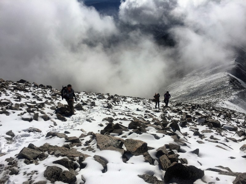 August of 2016 marked the tenth consecutive year that my brother Mark and I have trekked to Colorado to climb 14ers, joined every year but one by my daughter Maryjane. I think you could do it for 100 years and the mountains would still offer new and memorable experiences every year. Our 2016 experiences included climbing a snow-covered summit in August, and two memorable wildlife encounters. The first wildlife encounter actually came on our warmup hike, a climb of Bear Peak and South Boulder Peak with Mark's son Brian (Sikyou). It's a fun climb, actually comparable in distance and vertical gain to a modest 14er, with some neat views of flatirons and Longs Peak, and a nice little scramble at the summit of Bear Peak. But with a summit at only 8,500, it made for a good acclimation hike for two flatlanders on their first full day in Colorado. Brian, from nearby Westminster, had made "Bear-SoBo" his personal route, climbing it every calendar month in 2016. We took a loop route this day, starting from a residential street in Boulder and ascending Fern Canyon to the Bear Peak summit. After a short jaunt to the South Boulder Peak summit, we descended from the Bear-South Boulder saddle down Shadow Canyon, taking a lightly used side trail back north to our starting point. 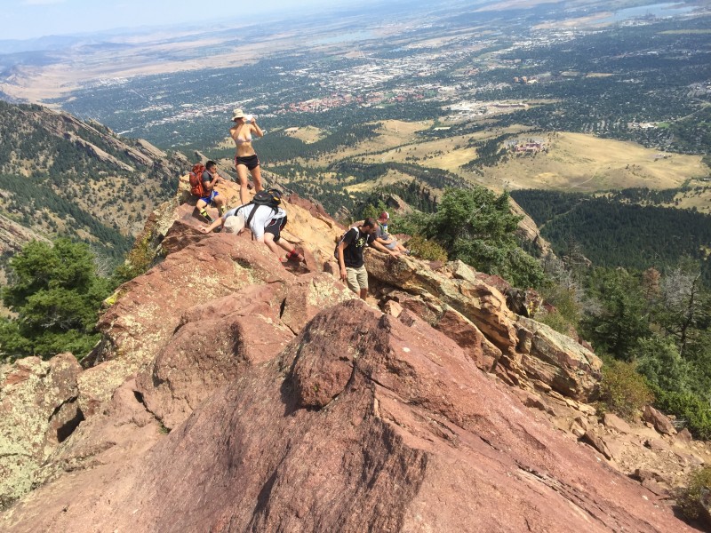 As we exited Shadow Canyon on the side trail, I was intrigued by a high-pitched buzzing sound emitting from alongside the trail. To my Midwest ears it sounded a lot like the noise grasshoppers or cicadas make rubbing their wings together. I paused and peered into the grassy slope beside the trail to see if I could locate whatever "insect" was making the noise. What I discovered was no insect, but rather a coiled-up rattlesnake. 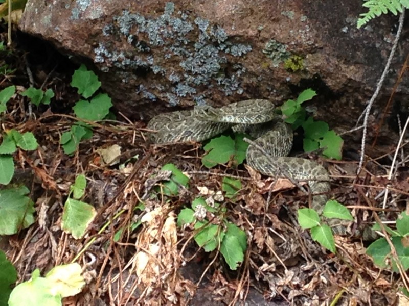 Mark, a few feet behind me, said my leap backward was the fastest he'd seen me move in several decades, accompanied by the spontaneous words of wisdom, "holy crap, it's a rattlesnake!" Bending over as I was, and looking in the weeds for a bug, I hadn't recognized the camouflaged snake until I was pretty close - I think about 30 inches, probably within striking distance. It did not strike, for which I will be forever thankful, because a rattlesnake bite to the face in that location would have been a serious matter. Not to mention I would have been in the news as a guy from Chicago who didn't know the difference in sound between a grasshopper and a rattlesnake. We warned off a couple behind us with a dog, who wisely decided to take a different trail. We briefly discussed whether we should take action to try to drive the snake away from the trail for the sake of any other hikers to follow us, but decided the wiser course would be to just leave the thing alone. With that experience behind us we set off for Princeton two days later. Our group consisted of Mark, me, Maryjane, and her now-fiance, Dennis. Dennis had proposed to Maryjane a few weeks earlier on the summit of Handies. He had totally nailed that process in my opinion, catching her completely unsuspecting with a classic proposal,. More importantly, he had properly preceded the proposal with a call to her father for his (my) permission. You young guys reading this - that's the way you do it. We always pick a relatively shot walkup for our first 14er of the year. This year, that strategy was complicated by a significant late August snowfall the preceding weekend. It had partially melted, but a blanket of several inches remained. on higher elevations all around the state, including Princeton's summit. What degree of difficulty it would add was an unknown to us. After a night at a cabin in Buena Vista, we planned to drive Mark's Rav4 up to some point near the radio towers at around 11,000'. That proved easy enough, after a moment's befuddlement about how to get onto the Mt. Princeton Road. After you turn off the paved CR321 road, you drive a short distance on the gravel CR322 road and come to the 2wd trailhead parking lot, marked with a wood fence and archway. We sat at that archway for a minute, thinking that's fine for the low 2wd parking, but where is the 4wd road that goes higher? Eventually we realized you drive right through the lower trailhead parking lot, and the CR322 road basically continues on out the back of that parking area. The several camping spots just above the towers looked pretty nice to me, other than lacking a water source. The sandy ridge appeared to provide good tent sites among elegant pine trees, with some views out over the Arkansas River valley. Were I to climb this peak again in summer, I would consider driving up with an ample water supply in my vehicle to camp on that stretch of ridge. We ended up driving a bit higher than the towers, parking at the first switchback above them, elevation about 11,250'. (3,000 foot rule? What's that?) The hike up the road made for a nice warmup and it didn't seem long at all until we saw the road ahead sweep up and to the left. Straight ahead of us stood the summit of the unranked 13er informally referred to as "Tigger Peak." We knew that was the cue to look for the trail leading up to the right, and sure enough, soon an obvious set of stone trail steps appeared. (We clarified on the descent that there are actually two sets of steps, the second set being in better condition. The two join to a single trail after a very short distance up.) Another short, easy stretch of trail crested the ridge at around 12,000', revealing a beautiful view of Princeton's summit, shrouded in snow. 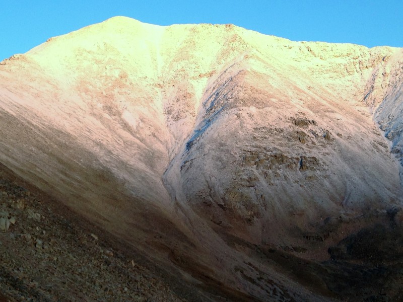 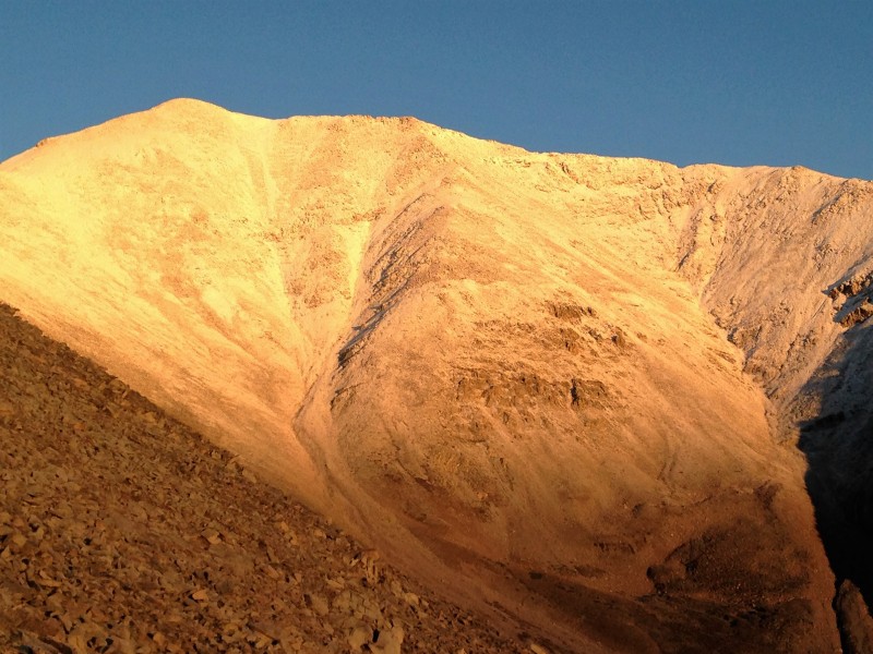 From the gentle ridge, a generally well-established trail winds through a talus slope with minimal elevation gain. If disappears in sections, due to rockslides per Bill Middlebrook's route description, only to re-appear soon afterward. It would typically be the easiest section of the route, but on this morning the north-facing slope sported a coat of verglas that made it slow and a bit treacherous. There is no exposure - the slope down to our right was gentle enough that an uncontrolled fall was no concern - but the kind of slip that could break a bone or tear up a limb was a real risk.  We picked our way along carefully. Somewhere around 12,600' to 12,800', we reached the beginning of the snow. We had harbored some concern about what the footing would be like in snow, but it turned out to improve when we reached that point, since the verglas dissipated. As we approached the saddle, some very welcome sunlight appeared. 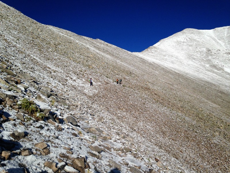 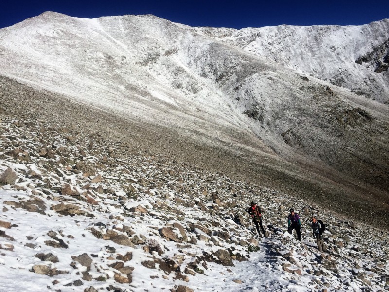 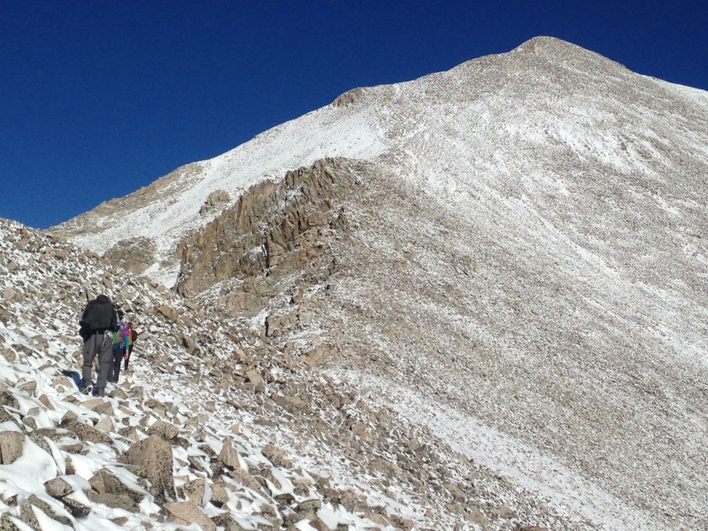 There was enough cloud activity to trigger our weather paranoia, which flares up at the slightest hint of potential trouble. But upon reaching the saddle with a long view west, the chance of precipitation seemed negligible. With cool temperatures minimizing the threat of convection-fired thunderstorms, the snow-capped Sawatch peaks spewed vapor aloft, creating some of the most picturesque rolling clouds that I have experienced.   The view was spectacular. The winds, clouds and snow only enhanced the beauty of the rugged wilderness stretching out for miles in three directions. It seems like every year there are a few special moments where I can pause to completely absorb the experience and remind myself, "this is why we do this." That view from the saddle, and continuing up the south ridge to Princeton's summit, was the first such moment for me this year. 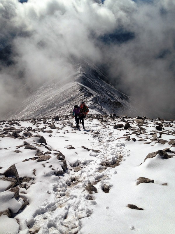 The snow deepened slightly as we ascended, but only exceeded a few inches in occasional drifts around boulders. The trail was a bit hard to follow at times, and steep scree slopes were indeed slick. But that was compensated by the fact that off-trail hiking seemed to me to be easier in a way due to the snow. The shape of the rocks below showed through, and I could pick secure foot placements with my steps landing softly in the snow. There was one tumble, when Dennis changed his planned foot placement in mid-step and landed his foot at an angle on a rock. He went down hard - hard enough to require a minute to sit and recover. But he suffered no apparent injury and, being a young guy, was soon up and on his way. I had a feeling if Mark or I had gone down like that, the effects would have lingered much longer. As we neared the summit we encountered this plaque, which I had not known of previously. As I read of it for the first time, tragedy it described sank deep into me, maybe because the age and character sketch of the young lady perfectly described Maryjane, standing beside me. We took a long silent pause, a time to appreciate the life God has given us. 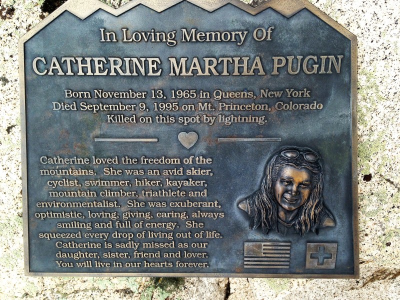 The first peak that looks like the summit from the ridge below turned out to be a false summit, which we have learned by now to expect. If I remember right there was a second false summit, but that one was only a short distance below the real one. Shortly after 10 a.m. we celebrated our tenth year of standing atop Colorado 14ers. We had the summit to ourselves. The weather remained essentially unchanged, affording a relatively leisurely summit stay. As we sat eating and chatting, someone hushed us to listen to a sound in the distance. To our north a cry arose which I thought for a moment to perhaps be a person whooping up a summit - but then quickly realized it was not human. After a few seconds it was identifiable: a pack of coyotes howling, presumably in celebration of a kill. It went on a long time, mournful extended wails, peaking and subsiding in the distance, new howls rising up to replace others trailing off. It was a haunting sound, a primitive song of life and death in the wilderness. And again I thought, this is why we do this. 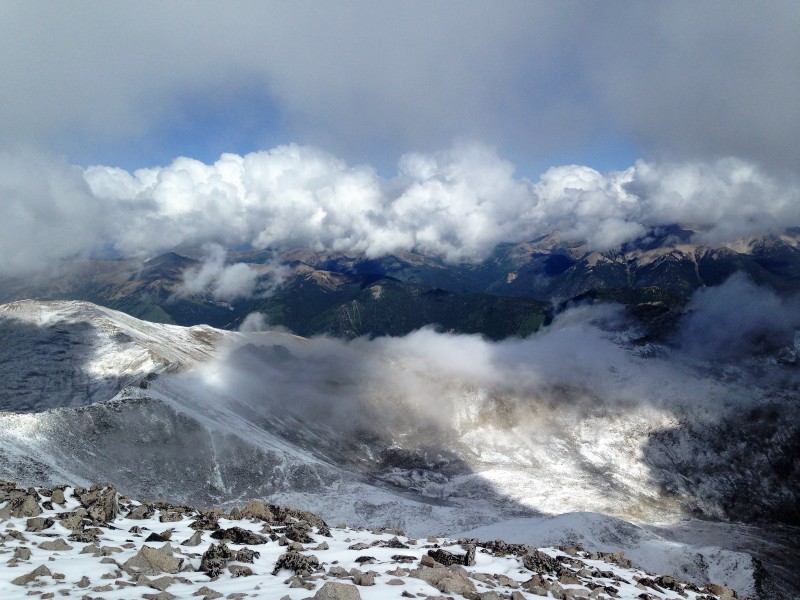 After our canine serenade concluded, we soon began a descent that proved to be blessedly uneventful. We encountered three or four other hiking parties on the mountain this Tuesday - a couple of solo hikers on our ascent, and one or two groups ascending as we descended. When we reached the talus traverse between the saddle and Tigger's west ridge, the ice glaze had long since melted off. 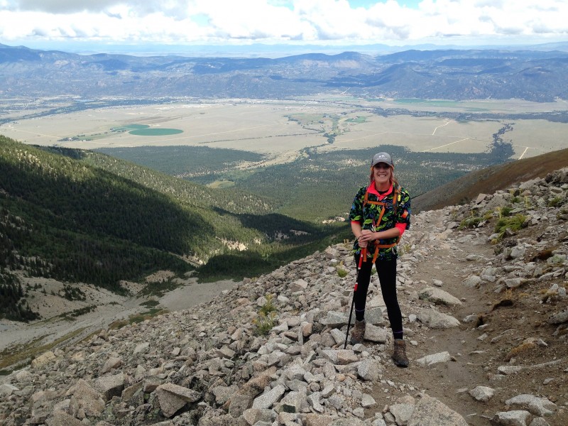 When we crested the ridge, we found a couple parties had parked their vehicles along the road where the foot trail leaves the road at about 11,850', and another vehicle was parked up at the mine all the way at the end of the road. Another SUV would pass us ascending as we walked down the road. It seemed to me that this road is a pretty easy drive about as high as you want to go, at least in dry conditions like we had. We capped off a great stay in Buena Vista with some whitewater rafting of the Arkansas River the next day (and yes, there was white water, the river still offering a pretty strong current for August in Colorado). Then we headed south to take a run at the Blanca Group.  Thumbnails for uploaded photos (click to open slideshow): ")
")
|
| Comments or Questions | |||
|---|---|---|---|
|
Caution: The information contained in this report may not be accurate and should not be the only resource used in preparation for your climb. Failure to have the necessary experience, physical conditioning, supplies or equipment can result in injury or death. 14ers.com and the author(s) of this report provide no warranties, either express or implied, that the information provided is accurate or reliable. By using the information provided, you agree to indemnify and hold harmless 14ers.com and the report author(s) with respect to any claims and demands against them, including any attorney fees and expenses. Please read the 14ers.com Safety and Disclaimer pages for more information.
Please respect private property: 14ers.com supports the rights of private landowners to determine how and by whom their land will be used. In Colorado, it is your responsibility to determine if land is private and to obtain the appropriate permission before entering the property.


