Download Agreement, Release, and Acknowledgement of Risk:
You (the person requesting this file download) fully understand mountain climbing ("Activity") involves risks and dangers of serious bodily injury, including permanent disability, paralysis, and death ("Risks") and you fully accept and assume all such risks and all responsibility for losses, costs, and damages you incur as a result of your participation in this Activity.
You acknowledge that information in the file you have chosen to download may not be accurate and may contain errors. You agree to assume all risks when using this information and agree to release and discharge 14ers.com, 14ers Inc. and the author(s) of such information (collectively, the "Released Parties").
You hereby discharge the Released Parties from all damages, actions, claims and liabilities of any nature, specifically including, but not limited to, damages, actions, claims and liabilities arising from or related to the negligence of the Released Parties. You further agree to indemnify, hold harmless and defend 14ers.com, 14ers Inc. and each of the other Released Parties from and against any loss, damage, liability and expense, including costs and attorney fees, incurred by 14ers.com, 14ers Inc. or any of the other Released Parties as a result of you using information provided on the 14ers.com or 14ers Inc. websites.
You have read this agreement, fully understand its terms and intend it to be a complete and unconditional release of all liability to the greatest extent allowed by law and agree that if any portion of this agreement is held to be invalid the balance, notwithstanding, shall continue in full force and effect.
By clicking "OK" you agree to these terms. If you DO NOT agree, click "Cancel"...
Rocky Peak was another mystery peak, a ranked 9er which was classified as 5th class in listsofjohn yet which had no logged ascents on that site nor any googleable beta about climbing it. The one bit of solid beta my research uncovered was a photo taken by a hiker which showed the summit area to be comprised of several large, granitic boulders. A hook or crook solo exploration and ascent seemed like a good way of distracting myself from my post-election malaise.
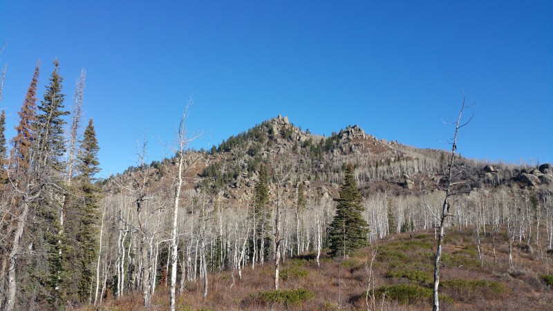
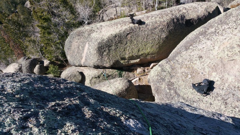
Rocky Peak from about 1000' below the summit
The first issue would be plowing through the 1.5 miles of scrub oak zone between the nearest road and the summit area. I parked in a pullout at the west end of a patch of public land, just east of Strawberry Park Hot Springs. I then walked back east on the road about 100 meters to where the vegetation looked thinner and then turned toward the peak. The bushwhacking wasn't terrible but the bow (brought in case I needed it to launch a line over the summit, preparatory to establishing a top rope) lashed to the outside of my pack repeatedly snagged on the scrub. After a few minutes of such thrashing, I stumbled upon a trail which was a real godsend, at least doubling my speed over ground and getting me to within about 1/3 of a mile from the summit. (I believe this unmarked trail intercepts the road around 40.5584,-106.8453.) I resumed bushwhacking which wasn't too bad until I hit some cliffs about .15 of a mile SE of the summit where progress slowed to almost nothing. I then flanked the cliffs to the east and found relatively easier ground which led without too much travail to the base of summit pinnacles. (Picture worth a 1000 words: look at my GPS track with satellite images.)
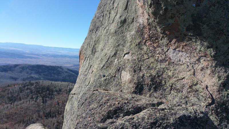
Once I'd wended my way to the west side of the summit area, I was encouraged by what I saw. The summit block was short enough that I should be able to get a line over it without resorting to the low-percentage bow and arrow. The summit pinnacle's east and south faces were about 50' high. The west side was about 30' high but had a long, flat 10' high boulder near its base. The most important revelation was the NE corner which featured a 10' offwidth crack ending at a good ledge; 6' above the ledge was a bolt of recent vintage and a foot above that was an old, suspect-looking bolt. Above the bolts, about 15' of slabby, unprotected climbing led to the top. It appeared that the program was to use the bolts to aid past an initial bulge and then run it out to the top.
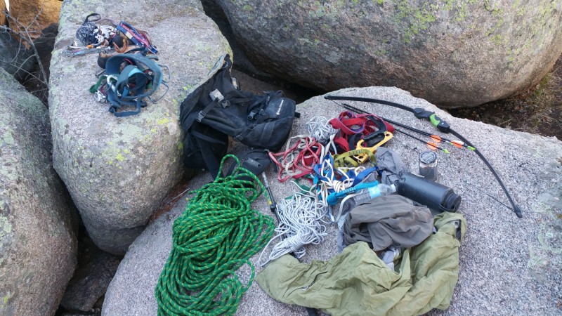
For a variety of reasons, all of which boiled down to self-preservation, I decided to try and rig a top rope over the pinnacle to allow me to self-belay an ascent of the NW side. From atop the flat rock on the west side (5.7 move), I duct taped a stone to some parachute cord and, after a few tries, managed to throw the stone over the top of the pillar and, with braking applied by the friction of the pcord over the summit, have it fortuitously come to rest within arms reach of the ledge below the bolt. I used the pcord to pull over a static rope which I anchored on the west side to the base of the flat boulder. When I returned to the east side, I didn't like that the rope was running over the shoulder of the summit spire instead of the center. I was concerned that if it were not centered, it might pop off the spire entirely when loaded so I returned to the west side and moved the anchor further south, better centering the rope.
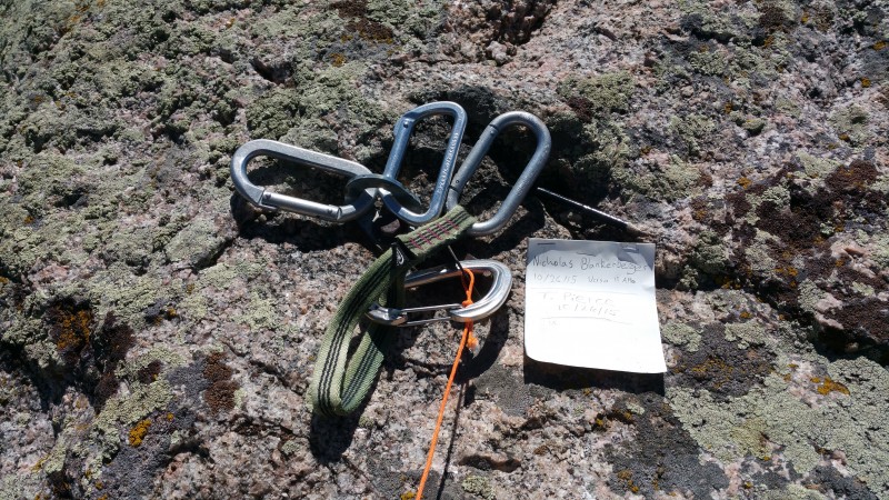
Once the rope was in a happy place, I returned to the bolt and climbed the NW face self belaying with a Grigri. I aided the first move crux using only the lower, good bolt. After the aid move was done, the climbing to the top was quite easy. On the summit there was a register apparently placed by Tom Pierce and partner a year earlier. I down climbed from the summit to the bolt and rapped the last move.
Quick beta on the NE face route:
Approach from the west via chimney / tunnel.
Start with north-facing 10' offwidth, ~5.3, which could be protected with a #4 Camalot.
From ledge atop offwidth, clip a solid bolt and aid awkwardly until standing on the ledge above the bolt. There is a manky bolt a foot or so above the good one which might help with the aid move. The aid move could probably be freed in the 5.10-5.11 range but it seemed to me that the good bolt was too low to safely belay the end of the sequence.
Once standing above the bolts, the climbing is 5.easy but was either mostly or entirely unprotected; one might get a dubious small nut in a horizontal, downward facing crack a body length above the bolt. Assuming no protection, a fall anywhere in the free section would be catastrophic.
Descent: there is one decent looking bolt on the summit. For some reason there were four carabiners keeping this bolt company.
The rock on the summit pinnacle is bomber granite. The west side of the south face seemed like it might have the makings of a good sport route.
Apologies for poor/incomplete photos.
Equippage Start of route. Rock on pcord in center of photo, just above the ledge. Bolt in shadow in upper right Monkey's Fist: rock duct taped to pcord Summit bolt/rap anchor and register. (Canister out of frame.) View from summit to the west. Pack is on rock from which tosses were made.
My GPS Tracks on Google Maps (made from a .GPX file upload):
Yep, that was my summit register. Fwiw, I use the same cerulean blue bottles whenever I place a register, I take some fish oil tablets and that's what they come in. I really like that shade of blue, beautiful.
And yes, there is a trail all the way to the summit from the road. It starts east of the Springs parking lot, there is a left spur up to Rocky right before the angle kicks up below the summit boulders. No need to bushwhack at all.
I placed the modern bolt last year. Ordinarily I'd have cleaned up the old hardware, but the existing stud proved surprisingly ductile, wouldn't snap and would barely bend despite many whacks with a yo-yo hammer. Did the best I could to make the new bolt unobtrusive, used a Metolius colored hanger, etc. And for those that care, this wasn't in a wilderness area and there had already been two previous bolts placed, but those were either broken or loose, rusty 1/4" death bolts (old Rawl stuff).
For those that want to free climb it, it's a pretty easy climb, maybe 5.8> from the pedestal dhgold mentions, which is accessed with a few 4th class moves. No 5.7 moves required. Enjoy!
Tom,
More details/specifics about the trail to the summit area would be appreciated. A better trail description would make future approaches easier and greatly reduce impact.
Also, the register on Rocky was damp. IME, repurposed plastic food containers, even if only the lid is plastic, inevitably fail. Usually animals destroy them, but even when animals can't get at them, the lid leaks. For a rarely visited peak, a glass jar with a metal lid (aka a Garrett register) works pretty well (if people put the lid back on snugly) though the lids often freeze shut on these. The only consistent effective register containers are ammo boxes but these are hard to come by and unwieldy to carry on technical peaks. Not sure what the ideal solution but reused plastic food containers is not it.
Caution: The information contained in this report may not be accurate and should not be the only resource used in preparation for your climb. Failure to have the necessary experience, physical conditioning, supplies or equipment can result in injury or death. 14ers.com and the author(s) of this report provide no warranties, either express or implied, that the information provided is accurate or reliable. By using the information provided, you agree to indemnify and hold harmless 14ers.com and the report author(s) with respect to any claims and demands against them, including any attorney fees and expenses. Please read the 14ers.com Safety and Disclaimer pages for more information.
Please respect private property: 14ers.com supports the rights of private landowners to determine how and by whom their land will be used. In Colorado, it is your responsibility to determine if land is private and to obtain the appropriate permission before entering the property.