| Report Type | Full |
| Peak(s) |
"North Traverse Peak" - 13,085 feet "Grand Traverse Peak" - 13,063 feet |
| Date Posted | 09/14/2016 |
| Modified | 09/15/2016 |
| Date Climbed | 08/19/2016 |
| Author | Tony1 |
| Additional Members | WillRobnett |
| The Grand Traverse |
|---|
The Grand TraverseNorth Traverse Peak (13,079 ft) Grand Traverse Peak (13,041 ft) Friday, 19 August 2016 Route: Ascend Bighorn Creek > Traverse North to Grand > Descend Deluge Creek Distance: ~10.2 miles R/T Gain: ~5100 feet Hikers: Tony and Will The Grand Traverse is a rugged ridgeline connecting two Gore Range 13er summits: North Traverse Peak and Grand Traverse Peak. The southern half of the Traverse is clearly visible from central Vail, including from I-70 eastbound as it parallels the golf course just east of the village. It is a Vail classic. Take a sip of wine here. Will and I decided to go for the Traverse on Friday, the 19th of August. We made a plan to complete the route as a loop and set up a car shuttle, leaving one vehicle at the Gore Creek / Deluge Creek trailhead, and the other at the Bighorn Creek trailhead. We met early in the morning at the Gore Creek / Deluge Creek trailhead, Will hopped in my car, and we drove a little over a mile down Bighorn Road to the Bighorn Creek trailhead. By 4:00 AM, we were heading up the trail. Before starting out, Will mentioned he was going to put on his rain gear. After looking at the grass, I decided he had the right idea and also put on my rain pants and jacket. The previous day was rather wet, and needless to say, the rain gear was a good idea. Specific information on the Bighorn Creek trail can be found with a quick Google search for the PDF info page and map from the USDA (the direct link doesn't work). We made quick time up the steep trail and arrived at the cabin a short time after it became light enough to turn off the headlamps.   We took a quick break and continued up the trail, now a climber's trail. It lasted until a large meadow containing a small creek, just below treeline. We followed it until it fizzled out and started to find our own way through the upper Bighorn Creek drainage. As we ascended through intermittent meadows and areas of scattered pine, there were plenty of areas where it was easy to tell the grass had been disturbed from previous hikers taking the same route.   After another break for food and water, we made our way farther up the drainage, this time following the interface between vegetated and rocky terrain. By this point, my feet were completely soaked, as I was wearing regular summer hiking boots. However, the rain pants and jacket kept the rest of me perfectly dry.  We began an ascending traverse along the lower northwest face of North Traverse Peak, with the intention of cutting straight up the face when the terrain above us became friendly enough. After that, we'd gain the north ridge of North Traverse Peak. There was lots of small talus hopping and scree, and much of this area was rather tedious progress. Soon enough, we located a higher rib located between two shallow gullies that lead up to grassy terrain on the upper face of the peak. After battling the dirt and scree, we made it to the steep grass.   Gaining the north ridge of North became instantly easier. It was chilly; the Sun had been up for a little while, but we'd had high terrain directly to our east since well before sunrise. Upon reaching the ridge, I basked in the glorious sunlight, and we sat down for one last breather before heading up to the summit of North. We gained the ridge at around 12,600'. 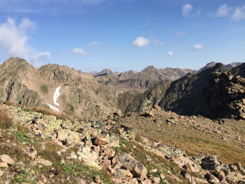 Until this point, I'd call the route class 2. From where we gained the ridge to the summit of North I would identify as class 2+. The rocks were bigger and there was some route finding, but nothing class 3 in my experience. If you are looking for something in the Gores and want more of just a hike, I would say that North Traverse Peak by itself fits the bill. The views are pretty outstanding, too.  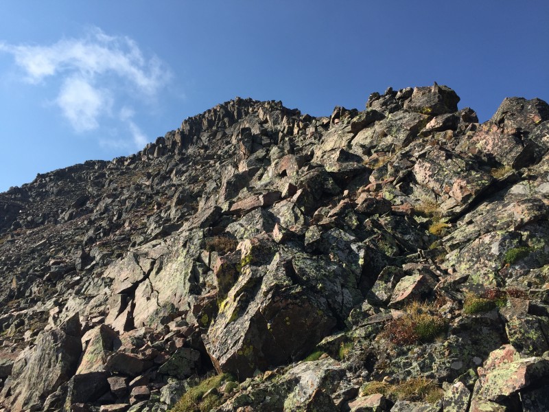 The summit arrived quickly, and speaking of outstanding views, you better believe we were enjoying those.   Looking northwest down the Gore Range.  The Grand Traverse. The weather looked like it was going to hold, so we made the final decision to move forward with the Traverse. As a side note, I estimated it'd take us about 1:30 hours at most. Spoiler alert: It took about 2:15 hours. We began the descent off the summit of North along the ridge. It was instantly fun. There was a small knife edge (walkable on the west side), and the route was somewhat narrow with big exposure, but easy to navigate. The west side of the ridge featured rugged terrain down to the valley floor, while the east side was more or less one smooth face of rock with a few large cracks crossing the entire vertical length.     We ascended to the top of the obvious point which marked about a third of the way across the Traverse. At this point when traversing from North to Grand, the terrain becomes more serious and demanding. We dropped off the summit as the ridge curved around to the southeast and negotiated the steep hike down to the mini-saddle with the next point, which was much more jagged.   One of the cool things about the Grand Traverse is that you can make it as difficult or easy (almost) as you want. If you don't mind the increase in total elevation gain and route finding, you could probably keep it somewhat simple by dropping west around each gendarme. On the other hand, you can make it India-spicy by staying directly on the ridge crest. We decided on a balance between the two. If I remember correctly, we decided to go around the first gendarme and climb the second one after reaching the ridge crest again. I went first, angling to the left and climbing up a shallow gully with a decent amount of exposure, as the gully we climbed emptied into a larger one that went down off the east side of the ridge.   Descending this gendarme almost gave us a problem. We originally explored our option to the west, only to find that it didn't exist. Well, perhaps it did, but I wasn't going to go down that rock face to the next little saddle. I made the short re-ascent back to the ridge crest to see if we had an eastern option. It checked out! We descended a series of small, grassy ledges on the east side of the gendarme/ridge crest and followed them around to the west side before descending the rest of the way to the next little saddle on blocky terrain.  With a combination of clouds having been rapidly building since we started the Traverse and just escaping the feeling of being trapped, I'd decided to be done with class 4 sections on the Traverse, and Will felt the same. We skirted the next gendarme and the next simply by following what we felt was the natural path of least resistance for the ridge as a whole, and soon enough found ourselves at one last gully to cross before making the climb to the top of Grand Traverse Peak.   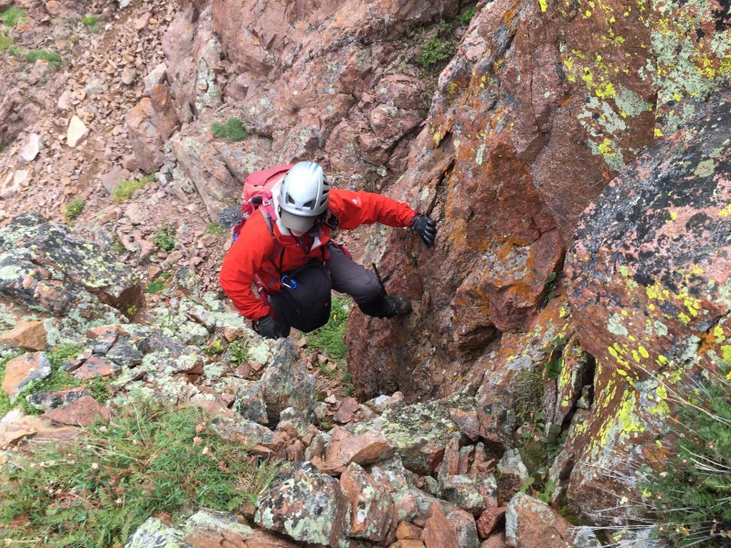 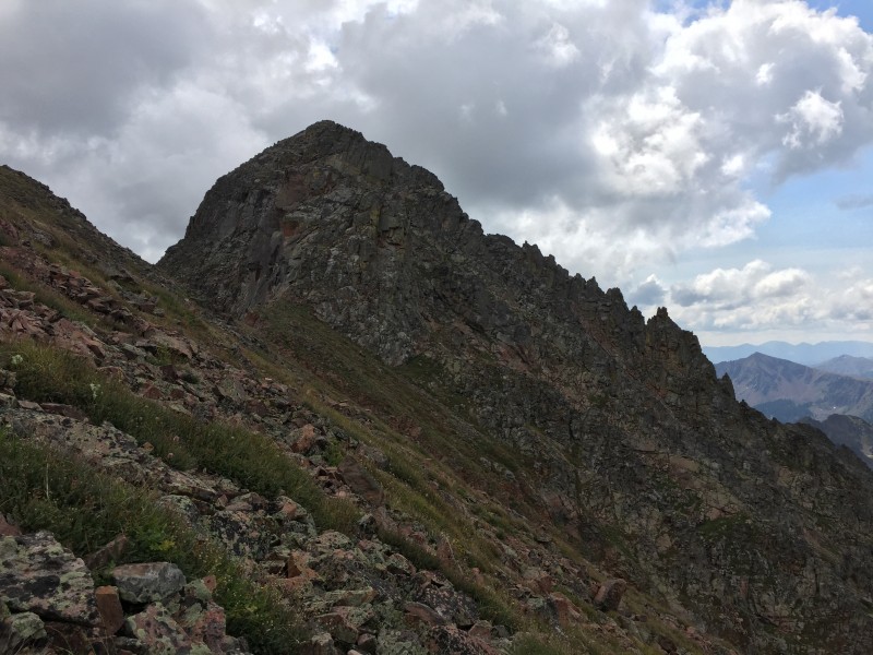 A bit of graupel fell on us as we crossed the gully a bit below the ridge crest and then made our way back up. I climbed up a tiny bit farther in the direction back toward North to get a better vantage point for a weather check. The graupel-producing cloud above us was about to blow over, and it was clear to the west and northwest behind it. Perfect. I re-joined Will at the last mini-saddle (higher than the real saddle) before our climb up Grand and scouted out an initial route. It looked fun, and it was. We found it to be continuous class 3 just about the whole way up, which wasn't very far. We split just before the summit to take slightly different routes; Will ended up with the more challenging one. He liked it, though.  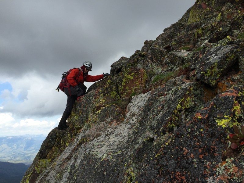 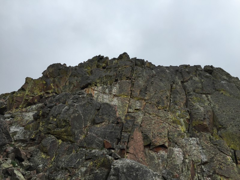  We gained the summit of 13,041' Grand Traverse Peak feeling fantastic. The weather was still holding over to the west of us and the views were incredible.   A wider shot of the view northwest from Grand Traverse Peak.  Deluge Lake and southern Gore 13ers: Valhalla, Silverthorne, Red, and Snow.  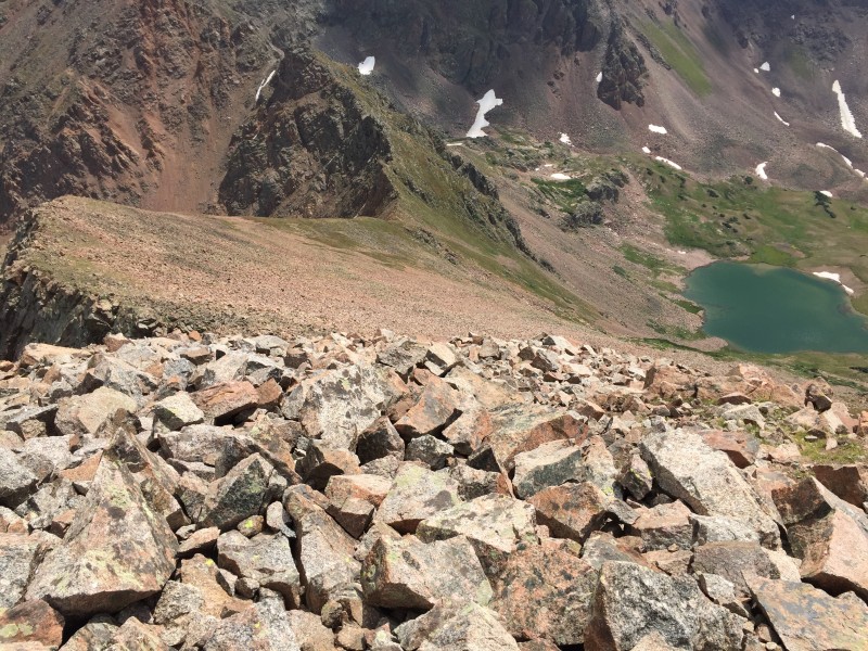 Both of us were pretty sure it would rain at some point, so we decided to get going and descend to Deluge Lake for a longer break there--if weather allowed--due to its proximity to the trees. We followed the east ridge down from the summit (only class 2 talus) down to a point where a grassy slope descended down toward the lake. We took the grassy slope which eventually steepened and turned into a somewhat brief section of dirt and scree - the type one can "scree ski" down. After that, we were basically at the lake and walked down the grass to a nice spot to take a break.     Deluge Lake view, with Mount Valhalla on the left and Snow Peak on the right. After a good rest, we began our descent down the Deluge Creek trail. The descent as a whole was rather uneventful, but the views of Snow Peak up high and the Gore Creek drainage down low were beautiful. We got rained on a little (no thunder though; woo!) and passed plenty of nice people hiking up the trail on our descent. One rather amusing encounter was with a couple of ladies who thought the "Grand Traverse" referred to the trail on Vail Mountain. Will and I shared a laugh over how we didn't know about that trail (even being locals who ski), and at the same time how the two ladies didn't know about the Grand Traverse in terms of the Gore Range peaks (even though they also seemed like locals).  Specific information on the Deluge Creek trail can also be found with a quick Google search. The USDA also has a PDF info page and map for that trail. We reached the Gore Creek / Deluge Creek trailhead around 3:30 PM, and Will drove me down to the Bighorn Creek trailhead to retrieve my car. Overall, the Grand Traverse was a blast. Being in the Gore Range, even if the distance isn't big, the elevation gain is, and the views and alpine experience are well worth the effort. Before committing to the Grand Traverse from either peak, check the weather and expect to take at least 2 hours, as it's rather time consuming for a short traverse (about 3/4 mile). Be safe and have fun with it; there is a decent amount of customization involved on this route. And as a side note, if you do have to bail, it's possible from a couple points to descend off the ridge to the southwest toward Vail. You can see this when looking at the route from Bighorn Creek. It may not be super fun, but the option is there if absolutely necessary. Also, a big thanks to Will for teaming up to tackle this route together! Thanks for reading. -Tony Thumbnails for uploaded photos (click to open slideshow):  The Traverse viewed from shortly before reaching the cabin.")
 The cabin.")
 Making our way into the upper portions of the Bighorn Creek drainage.")
 Looking back down the drainage.")
 Following the boundary between rock and grass.")
 Ascending up some somewhat tedious terrain.")
 The views started to open.")
 The view northwest along the Gore Range from where we gained the ridge.")
 Our initial climb up the ridge.")
 A bit farther up the ridge, closer to the summit of North Traverse Peak.")
 Looking southeast down the Gore Range from North's summit.")
 A mini knife edge feature.")
 Nice crack.")
 Making our way across the initial part of the Traverse, with the summit of North on the right.")
 The way to the prominent point partway through the Traverse.")
 Descending from the prominent point.")
 A natural window.")
 Someone's been here.")
 Will makes his way up.")
 Descending from our challenging gendarme.")
 A grassy ramp to use.")
 Traversing below the ridge crest.")
 Climbing out of a shallow gully.")
 The last shallow gully (barely visible) with the summit of Grand Traverse Peak rising above.")
 The first few moves of the climb up to the summit of Grand.")
 Making our way up the good rock.")
 Typical terrain on Grand's west ridge.")
 Will's route.")
 Summit view looking directly back on the Traverse.")
 Looking toward the HCW, as well as the town and slopes of Vail.")
 Our way to Deluge Lake from Grand's summit.")
 Descending from Grand Traverse Peak.")
 Looking back at Grand's summit from near the lake. The summit is on the left, and our descent route is visible on the ri")
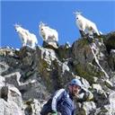
 A mountain goat near the lake.")
 Almost down.")
|
| Comments or Questions | |||||||||||||||
|---|---|---|---|---|---|---|---|---|---|---|---|---|---|---|---|
|
Caution: The information contained in this report may not be accurate and should not be the only resource used in preparation for your climb. Failure to have the necessary experience, physical conditioning, supplies or equipment can result in injury or death. 14ers.com and the author(s) of this report provide no warranties, either express or implied, that the information provided is accurate or reliable. By using the information provided, you agree to indemnify and hold harmless 14ers.com and the report author(s) with respect to any claims and demands against them, including any attorney fees and expenses. Please read the 14ers.com Safety and Disclaimer pages for more information.
Please respect private property: 14ers.com supports the rights of private landowners to determine how and by whom their land will be used. In Colorado, it is your responsibility to determine if land is private and to obtain the appropriate permission before entering the property.