| Report Type | Full |
| Peak(s) |
Taylor Peak - 13,157 feet Powell Peak - 13,195 feet McHenrys Peak - 13,330 feet |
| Date Posted | 09/13/2016 |
| Modified | 09/16/2016 |
| Date Climbed | 09/09/2016 |
| Author | C-Shepguy |
| A Mortal's Walk in the Park |
|---|
|
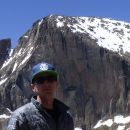
~16 miles (estimate based on other reports) ~5800 ft vertical (estimate based on topo maps) I owe this site at least one decent trip report, since I've done a lot of hiking around Colorado with the help of many of your reports, including this hike. I'll do my best to expand upon the already available information on this route. I love exploring in the National Park and collecting lots of high summits, and since this summer didn't allow me as many summits as I wanted, I was itching to get out there on a multi-peak route. I figured I would take a crack at this shortened version of the epic "Walk in the Park" (Hallet to Longs, Storm, etc) and get as many as I could. The main goal was McHenry's, with Chiefs Head being the "if I've still got gas in the tank" bonus option. Thursday evening I pulled into the Bear Lake parking lot around 9:30pm. I drove around looking for an open parking spot and was lucky enough to get one of the last 300 open spots. So far so good. Bed time in the car. Friday morning. 4:45am. Headed up the Flattop Mountain Trail. At the first overlook (Dream Lake overlook?) I saw the only other human I would be seeing for a long time; a guy doing some night photography. Coming up: 8.5 hours of solitude! (the exclamation point is just to emphasize how strange it is to be able to achieve this in the National Park, not because I'm that excited about being by myself. Better than crowds, though.) The Flattop trail is a very nice gradual trail which gets you up about 2800 feet, above tree line, to the "summit" of 12,324 ft Flattop "Mountain." It's not a mountain by any definition other than having a name on maps. In protest to it being called a mountain I have left it out of the official list of peaks in this trip report. Anyway, getting there is the largest single vertical push of the day and from this point you can see quite a bit of what's to come. I was reaching the top of this initial ascent just as the sun was coming up, which was pretty fantastic, with Longs already dominating the beautiful view to the Southeast, and the sun lighting up all this terrain to the northwest: 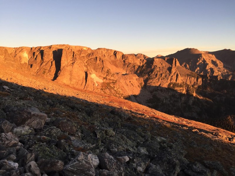 Wind was with me from this point on through most of the traverse, but never reached that point of making me question why I was up there. Hallet is right next to you once you get up Flattop. I skipped it, since I'd been up there not too long ago and was hoping to conserve enough energy that I might go for Chiefs Head later in the day. It was pretty easy to contour around Hallet toward Otis without extra vertical. It took me a little over 3 hours to get to Otis. From Flattop all the way through Otis, Taylor, and Powell is basically a tundra walk, with some light scrambling for the summit of Otis and nothing I can remember harder than Class 1 on Taylor or Powell. Otis sits pretty low compared to the other summits, so the push up to my 2nd peak, Taylor, is well over 1,000 feet at a sustained, moderate angle. Here's a view while descending Otis, looking up the long slope to Taylor on the right, with a nice angle of the Sharkstooth in the center, and of course Longs peeking out (pun?) over on the left: 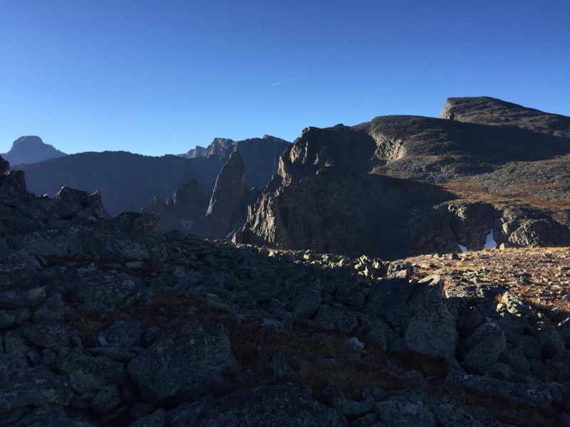 I say peeking out due to how this photo came out, but in reality Longs is a dominant presence during most of this hike. It really commands respect from this angle, as its prominence is obvious and it ends up being the main subject of most of your photos with the totally respectable 13ers you are working hard on just helping to frame it. Another note; due to the direction of this hike, you're walking toward the sun most of the morning, hence the less than perfect lighting in some of these photos trying to show the route. Hang in there, they get better! OK so about an hour and a half after leaving Otis I arrived at the summit of Taylor, which, while not being the main prize of the day, was probably my favorite summit to hang out and have a snack on. There is a perfect rock to sit on positioned next to the summit cairn to block the wind, with massive cliffs literally at your feet, and beautiful views down on the Sharkstooth and Sky Pond: 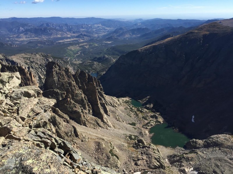 Turning to the South, you can view your path continuing along the ridge toward Powell, with Mount Alice in the background: 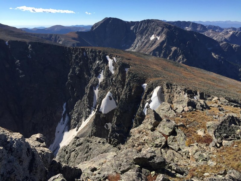 The Taylor to Powell traverse is pretty obvious...just following the ridge as it wraps around, contouring around an obvious sub-peak of maybe 100 feet of prominence. I took the path of least resistance to the summit which brought me up what I'll call the back side of Powell rather than the ridge proper. You could probably find more adventurous routes staying closer to the ridge. Powell's summit is somewhat forgettable due to what this hike becomes immediately after it. The view ahead: Longs Peak on the left, Chiefs Head on the right, and Mchenrys, dead center, probably only a couple hundred yards away but separated from Powell by the Notch. 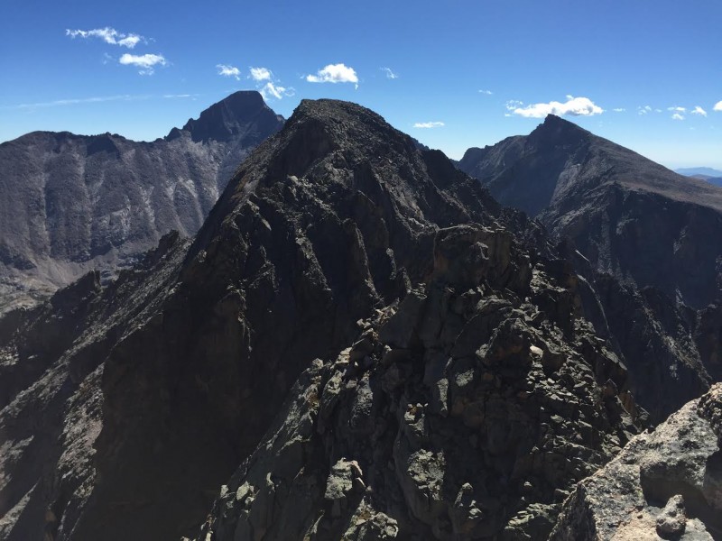 Others have described this part of the route pretty well so I will just add my perspective on a few things. The gully to descend toward McHenrys Notch is very close to the actual summit of Powell. Just continue along the ridge and you will see it drop down to your right. I originally thought I had to descend west a little bit to find it, but what I found over there was a larger gully which, even though it went to the same place, was full of snow. So I hiked back up and found the correct, slightly narrower, but snow-free gully with some clear signs of hiker use, and started down. As I knew to do from other reports, I kept an eye to my left for a cairn to exit the gully over toward the notch, and found it pretty easily. From gully to notch is actually a pretty cool traverse, probably 200 feet in distance, with some exposure but good solid places to step and a few more cairns along the way. McHenrys Notch is a very cool place. You can see it from a couple places very early on in this hike, and from many places in RMNP for that matter. It's such a deep cut in the ridge that without it, Powell wouldn't even be its own peak, and it just adds a bit of extra character to the RMNP horizon from many vantage points. Keeping in mind that now I haven't seen or heard another human in close to 7 hours, you can maybe get an idea of what it was like to stand there in that remote notch in the horizon. Here's the view to the Southwest, with Mount Alice above Lake Powell:  Climbing up out of the notch is rated at Class 4. It's sustained Class 4 for a couple hundred feet, so if you have any rock climbing experience at all and trust your hands, there isn't anything that difficult about it. I used to rock climb a lot so I really felt like there wouldn't be any excuse for not handling this section just fine. I did handle it fine, though it was a bit intimidating and I'm not sure I would recommend it to people with zero climbing experience. I say this mostly just because of the mental factor. You're up very high, it takes a long time to get there, and if you don't have a little bit of the rock-climbers confidence in your grip, I could see this being a pretty scary spot. Basically, if this wall was in your backyard, you would probably climb it before breakfast everyday with your Mom and your dog, but since it's sitting in the wind at over 13,000 feet after a long approach hike, it's a whole different feeling. The wind was definitely an extra mental factor for me. It wasn't crazy. Just enough to remind me that the mountain didn't care what happened to me. I made it up out of the notch in probably ten or fifteen minutes. When I got to the top of the Class 4 stuff, I was a little too far to the left, and realized I was topping out on a super exposed narrow ridge. I retreated back a bit, checked out things over on the right, and realized this was the easier way. (If you haven't had enough exposure at this point, by all means, go left). On the right, you can follow some fairly tame ledges along the back side of McHenrys until they yield a pretty easy route to the proper summit, a few hundred feet from the notch. Done! (not really) McHenrys was my main goal for the day and I was happy to not only get a little peak-bagging out of my system, but to stand on one of the more difficult summits in the National Park (hardest 13er in the park?). It's right next to Longs Peak and I think it would have to be ranked as more difficult than Longs...partly because of the Notch protecting one side, and partly because the way I was about to descend did not seem like something I would ever want to come up. Oh, almost forgot, better pictures. 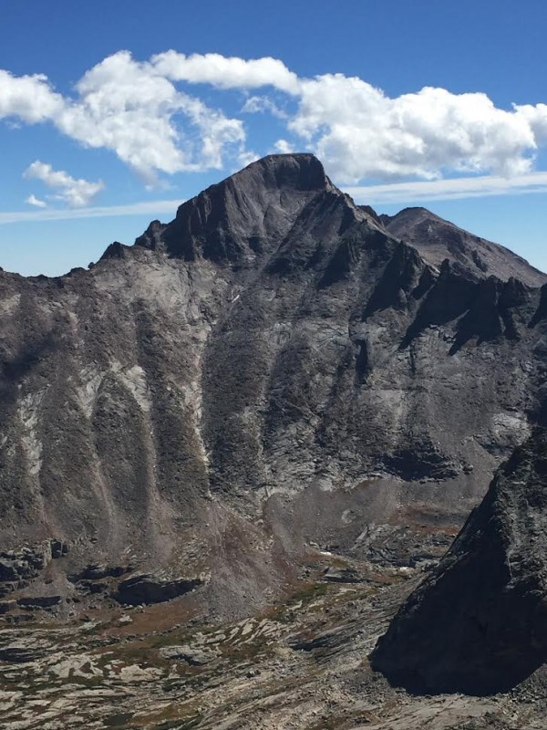 Longs! Looking as massive as ever from over here on McHenrys. Hard to believe there are non-technical routes to the top when you look at it from this vantage. 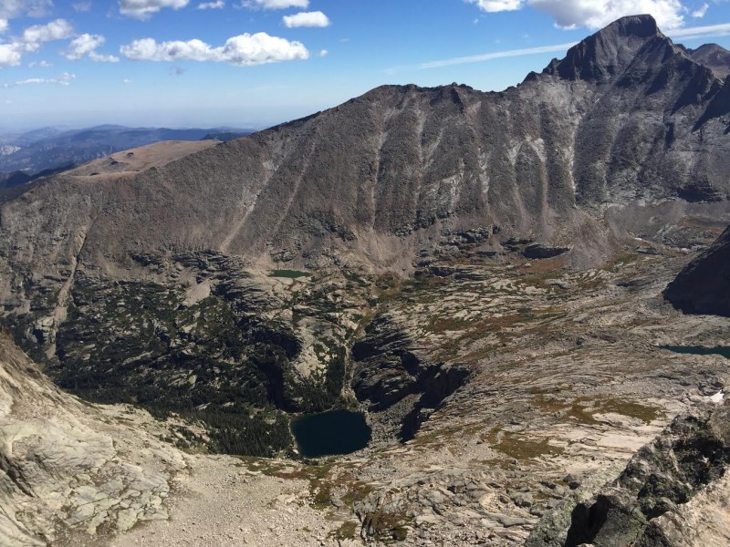 The above photo is the view of Glacier Gorge from McHenrys. I think it's an important one to study because it shows Black Lake, which was now my destination, so I could get back on a real trail and follow it back down the gorge to the trailheads. See that gully on the opposite side of the lake which runs from the Longs side down to the shore? As far as I know, that's the only reasonable way down to the lake, and the rest of it is basically surrounded by huge cliffs. I'm not a runner, but I walk down mountains pretty fast, and it still took me 4 hours to get from the summit of McHenrys back to the Bear Lake TH. Cairns lead the way through Class 2 and possibly Class 3 terrain down the back side of Mchenrys Peak to Stone Man Pass. I always thought that if a place was officially named a pass, it had some sort of trail through it, at least enough to make it passable for more than just 6 legged creatures. Not necessarily the case with Stone Man Pass. The first few hundred feet below the "Pass" pretty much sucked. Steep, loose rocks and dirt. I found hugging the left side, against the cliff walls, at least put me on some larger rocks eventually, and then I had to traverse all the way across the basin to be positioned to get down to the lake. This basin is huge, and beautiful, but I'm pretty sure whoever built cairns in it was drunk at the time, and it takes some work to get across it. I lost the cairn trail multiple times, tried to find some shortcuts down to the lake, got cliffed out 2 or 3 times, and eventually found a real trail in that gully down to the lake. If you want to get down as easily as possible, either reach the same level of intoxication as the cairn builder so you can follow his cairns, or just aim for Longs until you've lost enough altitude that the lake gully will be easy to walk to. Don't bee-line it toward the lake. Thanks. How about Longs and the Spearhead with some Fall colors: 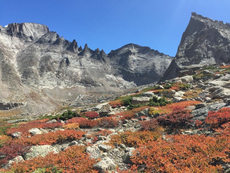 And Arrowhead above Black Lake: 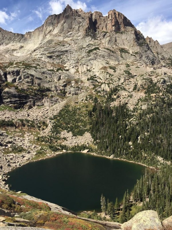 Once I was back near Black Lake, I found some humans again. From there, it's an easy trail stroll 4 or 5 miles down to the Glacier Gorge TH, which has a pretty quick spur back up to the Bear Lake TH, and the day was complete! 4:45am Bear Lake TH 8:00am Otis Peak 9:40am Taylor Peak 10:50am Powell Peak 11:40am Mchenrys Peak 1:30pm Black Lake 3:30pm Bear Lake TH 10.75 hrs. Closing thoughts. I just realized I never mentioned Chiefs Head again, soooo I'll just do that here. Looking up at Chiefs Head from Stone Man Pass, as expected, I didn't have it in me. I would say that this point in the hike is where the normal folk are weeded out from the mountain rock stars. It's about another 1,000 foot gain, looks a little ugly on the lower portion, and Mchenrys kind of makes you feel like you've done enough for one day. Next time, Chiefs Head. Today I only wanted the peaks with the boring white guy names anyway. Thanks again to everyone who already posted information on these peaks and all the other lesser-known but fantastic mountains in Colorado. Having the information did not take away from the adventure. It just allowed me to begin the adventure in more far-flung places. Thanks for reading! Thumbnails for uploaded photos (click to open slideshow):
|
| Comments or Questions | ||||||||||||
|---|---|---|---|---|---|---|---|---|---|---|---|---|
|
Caution: The information contained in this report may not be accurate and should not be the only resource used in preparation for your climb. Failure to have the necessary experience, physical conditioning, supplies or equipment can result in injury or death. 14ers.com and the author(s) of this report provide no warranties, either express or implied, that the information provided is accurate or reliable. By using the information provided, you agree to indemnify and hold harmless 14ers.com and the report author(s) with respect to any claims and demands against them, including any attorney fees and expenses. Please read the 14ers.com Safety and Disclaimer pages for more information.
Please respect private property: 14ers.com supports the rights of private landowners to determine how and by whom their land will be used. In Colorado, it is your responsibility to determine if land is private and to obtain the appropriate permission before entering the property.