| Report Type | Full |
| Peak(s) |
Mount Winchell - 13775 |
| Date Posted | 09/07/2016 |
| Modified | 09/10/2016 |
| Date Climbed | 09/02/2016 |
| Author | dhgold |
| The long day wanes on the West Ridge |
|---|
|
Since I recaught the peakbagging bug about seven years ago, I'd only climbed a handful of high California peaks but each of them had been among the most enjoyable and satisfying of the around 3000 (get a life!) summits I'd reached in those years. I hankered to return to the Sierra's reliably sunny weather, long steep alpine faces and its more "mountainy" peaks but circumstances had intervened. I'd long since targeted Mt Winchell's West Ridge as a prime objective as Winchell was one of the highest peaks in the lower 48 that I hadn't climbed while the route itself, according to the scant information I could find on it, sounded like a moderate alpine rock climbing classic with a first ascent by a pair of legends, Galen Rowell and Warren Harding. However, as the years went by and my rock climbing hours, fitness and mojo shriveled, the West Arete's rating of IV, 5.8/5.9 PG13 seemed like less of a casual romp and more of a serious undertaking. As concrete plans finally materialized, I did something to my left bicep which had it feeling continually pumped. Meanwhile, my partner for Winchell, Randy, barely rock climbs at all anymore, so infirmities and self-doubt notwithstanding, I'd have to be the rope gun. Comparisons with the Beckey-Chouinard route on South Howser Tower in the Bugaboos, which Randy and I had climbed up in '92, kept coming to mind; a friend had recently asked if we'd needed to bivvy while climbing its 2000' of 5.10 -- heck no! we'd blasted up it in 9 hours and were cragging at Squamish the next day. But time closes all, and now the 1100' of Winchell's West Arete loomed as large the Beckey-Chouinard had BITD. Our trip did not get off to an auspicious start. We'd gone back and forth about whether to meet in Vegas or LA, with the former being a little closer to the Sierra but much more prone to beyond-our-control snafus. We opted for LA where a major snafu engulfed each of our separate flights which both landed around 930 PM; a (false) report of a "live shooting" caused the airport to be closed and evacuated. When we showed up 3.5 hours late to get our rental car, the reservation had been canceled and the high clearance SUV which I'd reserved was no longer available. Our plan had been to "warm up" on the east ridge of Mt Humphreys the approach to which starts with six miles of high clearance road. On the drive from LA to Bishop we tested the rental's rough road capabilities and found them completely lacking as the vehicle became mired in such an innocuous stretch that we both wondered if it had come out of gear. So the idea of taking it up six miles of much rougher road was a non-starter and given that the temperatures in Bishop were pushing 100 degrees and that we had no appetite for adding twelve miles of shadeless inferno-trudging to the already full day that Humphreys would have been, we improvised a plan b. Randy wanted to minimize the altitude factor on Winchell so we decided to do the class 1 hike up the 14er White Mountain as our warmup. So that and a few of its satellite peaks replaced Humphreys. The most noteworthy thing about White was how much cooler it was, three layers for much of the day, than it was in Bishop 10000' below and the metal foot locker at the summit, filled with what seemed to be decades worth of registers; I wondered if I dug through them if I'd find my entry from 1984 but I didn't make the effort. 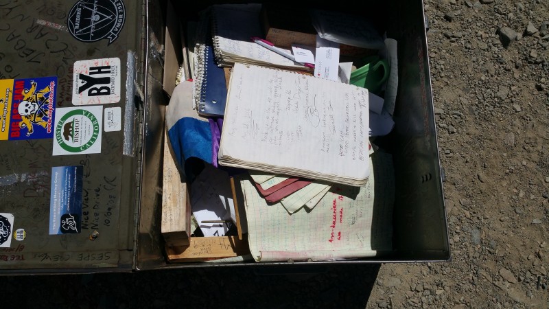 We spent the next day vegging out in Bishop and acquiring food and permits. Note that the permit I reserved (unused, non-refundable) through recreation.gov cost $16 but the permit I obtained for Winchell/Bishop Pass/Dusy Basin from the ranger station in Bishop was free. Availablity of walk-in permits is limited; the trick is to get there when they open at 0800 and put your name on a list though the permits aren't actually issued until 11. The next morning found us at South Lake, around 9700', each slowly cramming and lashing 60 liters of gear into and onto 40 liter packs. 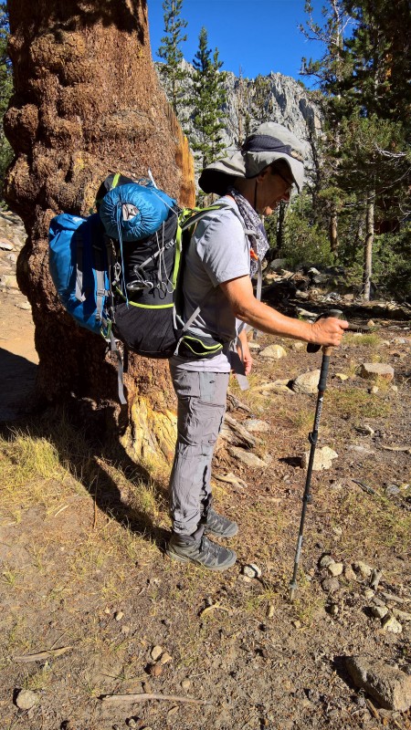 Anything remotely scented that didn't go with us went into a bear locker; one of the downsides of climbing in the Sierra is the local bears who to paraphrase SuperTopo, are "smarter, stronger, hungrier and more determined than you". (No time for them here, but I've got some stories.) Then it was onto the Bishop Pass Trail which I had not trod since a nine-day backpacking trip a full 36 years ago (ahem). I'd completely forgotten what a fabulous trail it is with a succession of charming lakes and jagged peaks -- IMO, the only thing in CO that comes close is Ice Lakes basin. At the pass we had lunch and I tromped up Mt Aggasiz (13,892') while Randy conserved his energies for the next day's main event. Norman Clyde's old school (teacher) rating of class two for Aggasiz's NW slopes once again had me pondering how tough the ratings are in the Sierra. 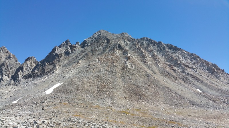  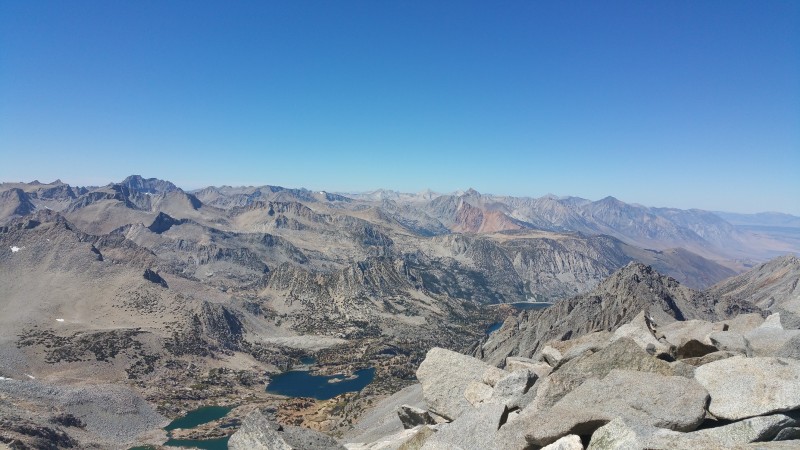 After Agassiz, we headed cross-country for about a mile and set up camp at a small pond at 11,600' about a kilometer WSW of Winchell's summit.  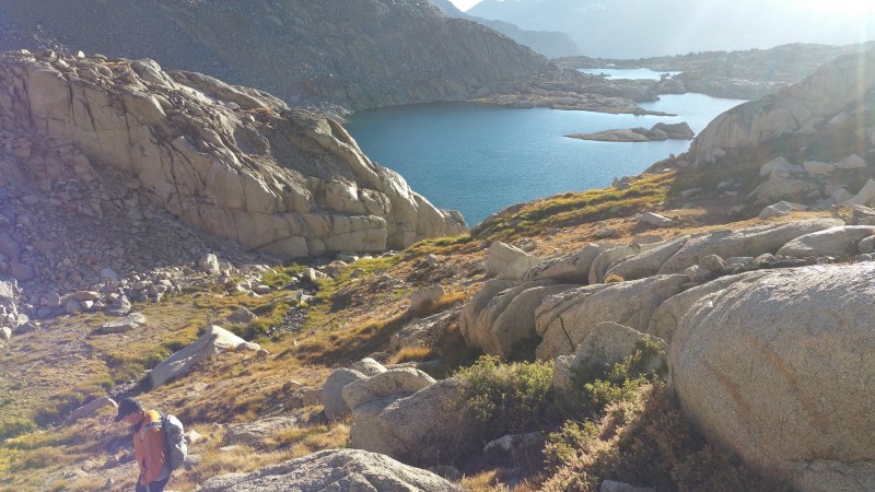 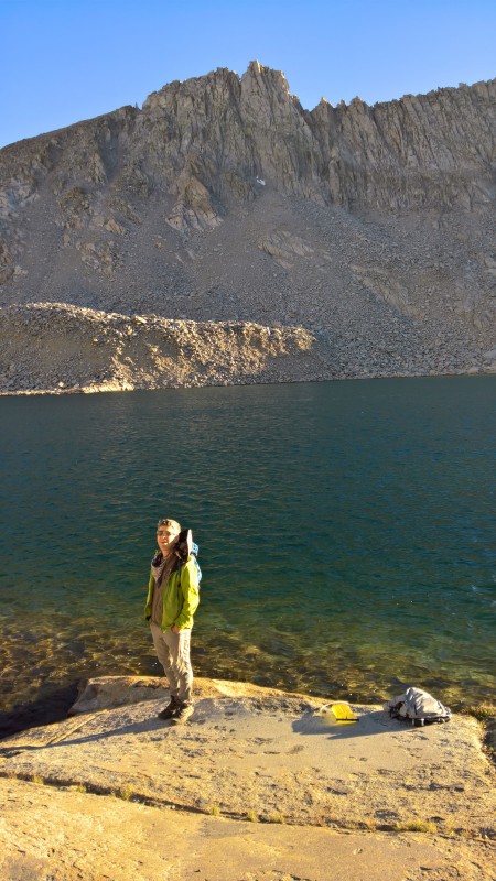 At this point we spent a while looking at the complex terrain of Winchell's west face which contained three west facing aretes. I had not thought we'd have any difficulty identifying our intended arete, particularly since we had photos from two different sources with the route marked on them. Close inspection, though, revealed that the photos did not agree about which arete we were supposed to climb. Turns out the "West Arete" marked in Secor's book is not the one the route is on; we were happy to reach this conclusion since the feature Secor named looked quite ferocious for the grade. In general, Secor's description would have been useless. The only good source of beta we found for the route was by Misha Logvinov and posted on both Mountainproject and Summitpost; his account provides partially accurate beta for the approach, good beta for the descent but deliberately preserves the mystery of the route itself as something for climbers to uncover for themselves. 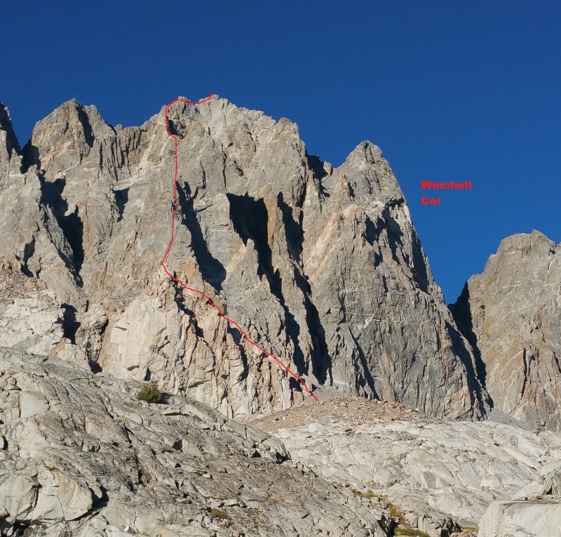 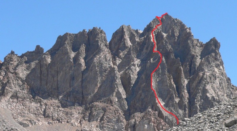 We dallied somewhat the next morning, hoping it would warm up a little and didn't leave camp until 0640. We tried to follow Logvinov's directions to the start but after a while, things didn't match up and we were on our own. Just north of the base of the northernmost west arete (the one the route is on), there are some very distinct white cliffs at least 100' high. Following Logvinov's directions, we traversed along the bottom of these until they ended at a chute of talus, scree and dirt. We went up this chute at class two and reached a small saddle. At this point, the only way up was to the right/south on 5th class ground. According to Logvinov's directions, we were supposed to climb to the left/north; a picture of the start of the climbing didn't match up with anything so we decided to work with what we had, climbing up a north face on the west ridge to gain the ridge line. To make Logvinov's directions work, we would have had to descend to the base of the gully and traverse further south to the next gully and gain the ridge from the south. Pitch 1 was about 60 meters of moderate, slabby 5th class. 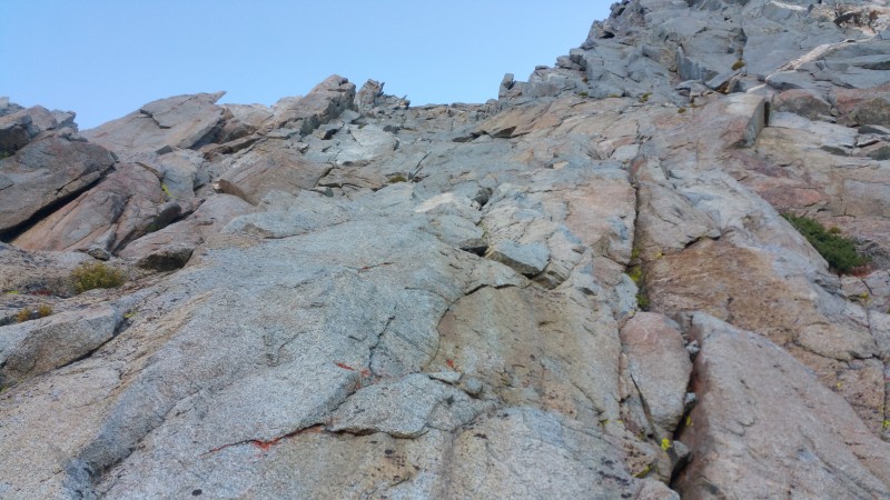 Pitch 2 was a little easier and around 40 meters; we'd hoped it would get us to the arete but what we thought was the arete was only a spur off the main arete. 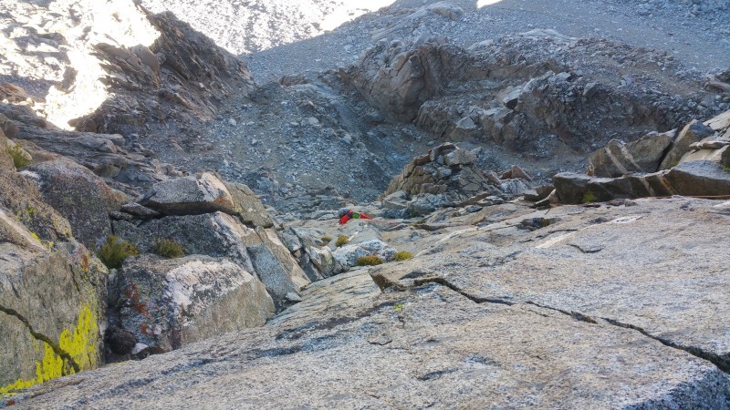 Pitch 3 offered distinct left, right and straight up options; we chose to go left which turned out to be the crux of the climb. The technical crux was a blankish corner protected by small cams; on lead, I french freed one move but Randy followed it clean. The business was a mantel onto a ledge completely covered in loose rocks and dirt -- it didn't seem like it had ever been climbed before. I unhappily contemplated this move for a few moments until I realized I could make a high placement with our one micro nut and suddenly the move seemed much less imposing. Overall the protection of this climb was very good with an obvious placement almost anywhere one was desired. Pitch three, shorter than P1 and longer than P2 ended at a little notch on the arete proper. We were psyched as it seemed like we'd overcome route finding difficulties, a lot of progress had been made quickly and the climbing had felt easier than the route description had led up to expect. Also, we were in the sun for the first time all day, a big morale booster.  At this point, the climbing went on and on with the summit remaining stubbornly far away. A somewhat unique feature of this climb is how much of it is horizontal with the arete proceeding in stairstep fashion. The horizontal stretches prevented using our 70-meter rope to full advantage with full-length pitches since when the rope ran horizontally it was not possible to keep a close, safe belay. 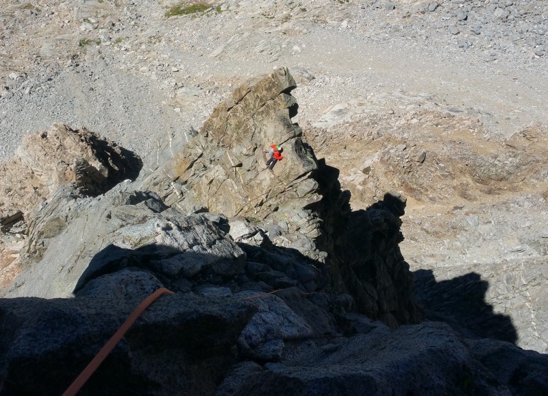 Around pitch six we passed a gendarme easily on the right. A couple of pitches later we encountered a second gendarme, the one which had made a big impression on Logvinov and which he implied was the psychological crux of the climb at runout 5.8+. We went left around this gendarme, as he had, but must have found a better line as the climbing seemed easier than he'd described while the protection was everything you could ask for; the climbing was quite enjoyable to boot.  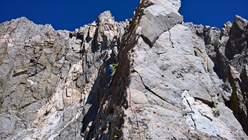 Higher up our lack of rock climbing fitness started to tell with bonking, muscle cramping and general tiredness setting in. Even though we felt that we'd been moving well, time was still of the essence so there was nothing for it but to eat a bar while belaying and keep going. Another interesting development was that grinding through some chimney section had worn several substantial holes in my pack; at first I thought "what are you going to do" but then I realized my hiking boots were in the pack and that if they were to fall out and disappear into the void, I would be way up the creek; so the boots were transferred to Randy's pack. The last two pitches featured some easier than it looked chimneying and a nice change of pace tunnel section. The route kept going to the very end with the final belay about 5' below the summit. 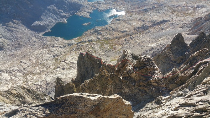  Overall we found the climb to be easier than Logvinov had indicated but just as committing (after about four pitches, retreat would be unfeasible) and time-consuming with just the roped climbing taking around ten hours. The roped climbing was 15 pitches which except for two short 3rd class horizontal transitions, were all more than 100' long with four in the 200' range. The route finding is less straightforward than Logvinov implies it is. Protection was good and the climbing friendly -- almost every time one was wanted, a good jam, jug or foothold appeared. Even though the underlying rock was bomber by alpine standards, loose rocks were a constant. Logvinov's rack recommendation was appropriate except that we brought and used more runners; we also found TriCams to be very handy. This route has as much horizontal as vertical climbing. We brought a 70 meter rope instead of the recommended 60 because my 60 and 70 weighed the same; the extra 10 meters did not appear to buy us much but did cost something in having to pull up and stack an extra 10 meters at the end of every pitch. (By the end of the climb the pinch muscles in my hands were completely blown.) A major theme of both Logvinov's route description and a TR on Summitpost was "leave room for dessert". The descent is long, complicated and, at points, harrowing. Logvinov's descent directions are quite good. From the summit back to camp took us about three hours. If there is no snow, as was the case for us, from the base of the east ridge to the north end of Winchell Col is ten minutes of straightforward class two. The descent of the gully below Winchell Col blows with much opportunity to knock rocks on each other and a couple 5th class downclimbs; you really don't want to do this part in the dark. The rap anchor at the bottom of the gully as of this writing is bomber but it is not easy to spot -- it is at skier's left, about 10' higher than you'd expect. This climb is a full-value Grade IV. From camp to camp we covered about 1.5 miles with 2200' vertical and needed 14 hours. Though much is taken, much abides. Thumbnails for uploaded photos (click to open slideshow):
 Our approximate route marked in red")
")
 Pitch 3, our crux")
 View N from Agassiz. Highpoints are Darwin, Humphreys and Tom")
|
| Comments or Questions | ||||||||||||
|---|---|---|---|---|---|---|---|---|---|---|---|---|
|
Caution: The information contained in this report may not be accurate and should not be the only resource used in preparation for your climb. Failure to have the necessary experience, physical conditioning, supplies or equipment can result in injury or death. 14ers.com and the author(s) of this report provide no warranties, either express or implied, that the information provided is accurate or reliable. By using the information provided, you agree to indemnify and hold harmless 14ers.com and the report author(s) with respect to any claims and demands against them, including any attorney fees and expenses. Please read the 14ers.com Safety and Disclaimer pages for more information.
Please respect private property: 14ers.com supports the rights of private landowners to determine how and by whom their land will be used. In Colorado, it is your responsibility to determine if land is private and to obtain the appropriate permission before entering the property.


