| Report Type | Full |
| Peak(s) |
Longs Peak - 14,259 feet |
| Date Posted | 08/28/2016 |
| Date Climbed | 08/14/2016 |
| Author | jfm3 |
| Summer Outings in Rocky Mountain National Park |
|---|
|
Ruminations in Rocky Mountain National Park May 29, August 14 and August 20, 2016 I've been to Rocky Mountain National Park three times so far this year- once in May with Corey and twice in August- first with Laura and Tayler to do Longs Peak, the second as a solo outing in Glacier Gorge. This is a compilation of various experiences and thoughts from all three of these trips. Corey and I went to RMNP on the Sunday of Memorial Day weekend. We didn't realize until we were sitting in a half mile-long line of traffic that we picked probably the busiest day of the busiest weekend of the entire year. Whoops. These thoughts quickly evaporated as we sped past everyone and went through the NPS annual pass lane and then had only open road ahead of us. We spent the morning hiking to Dream and Bierstadt Lakes. Aside from dealing with all the people on the trails, I spent most of the time looking at Longs Peak. Despite the calendar reading May 29, winter was still in full force above about 11,000 feet. The snow started abruptly at the treeline and the upper reaches of all the peaks around Glacier Gorge were still buried and icy. Sitting at Bierstadt Lake, I realized for the first time just how dominant Longs is as the centerpiece of the park. I could see the Boulderfield below the north face, and I wondered what it would be like to look down on the park from that lofty shelf on the mountain. 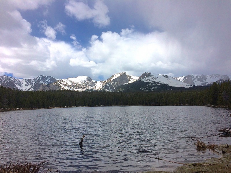 Corey and I hopped out to a rock near the shore of the lake and sat there for about 45 minutes, watching the sky roil and boil above us. A dark band of clouds moved in over Hallet Peak and Flattop Mountain. After a few minutes of scrutiny, we could see two tiny dots moving across the huge snowfield. One skier was descending, silently carving turns as he dropped toward the treeline. The other skier was positively flying up the hill- he ascended quickly toward the summit, where we eventually lost sight of him amongst the rocks. To the east, a wispy cloud quickly formed into a snow squall and engulfed the top of Longs. If anyone was on top that day, it probably looked like the middle of January up there. 15 minutes later the cloud was gone, the only trace of its passing a few more inches of snow. The oft-repeated warning of Longs creating its own weather was certainly true. On the trail to Dream Lake I could see the western side of the Longs summit block, where I knew the Ledges and Trough marked the first parts of the ascent beyond the Keyhole. Looking up at the snow-covered route, I had a moment of hesitation about my plan to summit Longs later in the summer. Yes, the snow would be gone, but the west face looked immensely steep. How tenuously did the route cling to the side of the rock? This view of the steep, rugged nature of the peak was much different than the Meeker-obscured vantage of the flat summit that I so often saw from Boulder. Ah well. I'll figure it out in the summer. We drove up Trail Ridge Road in the afternoon. This road is my new favorite alpine highway in Colorado. What a place. We went straight to the visitor's center on the west side of the plateau and spent a few minutes looking at the enormous snowdrifts in the parking lot. I also looked at the very top part of the Old Fall River Road. Now there's a major plowing operation. Holy smokes. No wonder it's only open for 3 months each year.  The drive back to the east side of the park was easily the best part of the day. There was a large storm moving east over the plains, another band of clouds to the west and completely clear skies right over the park. It was about 5 pm and the sun was my favorite color of light- soft gold, bright enough to softly illuminate everything but dark enough and just low enough in the sky to cast some shadows.   We stopped at several turnouts to take pictures along with what seemed like everyone else in the park. I often have a slight level of...not disdain, more like sorrow or empathy for the proverbial "tourist"- one who simply drives from point to point around the park, never getting out on their own two legs. Or the person who joins the multitudes and "hikes" the one mile of paved, flat trail from the Bear Lake parking lot to Dream Lake. Obviously not everyone is capable (or, indeed, willing/appreciative of self-caused suffering) of spending 8 hours in the mountains or running 20 miles just because it's a decent way to spend a Saturday, but there is so much more to see and experience than just a mile out-and-back on a pavement trail! These thoughts all passed through my mind as I watched a family take several pictures of themselves all posing in front of their car. I wanted to approach them and say something like "Look! Look around you! There is world-class alpine scenery literally right behind you, turn around and appreciate it!" But, clad as I was in shorts, sandals and a light jacket, I realized I looked no more the outdoorsman or athlete than anyone else running around in the snow. 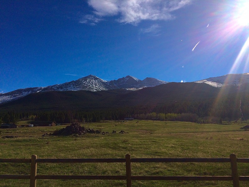 My second trip to RMNP came via my first ascent of Longs Peak (17th 14er overall). I went with Laura and Tayler. Laura and I had been planning to do this since I found out she was coming to CU for grad school in April, and when I mentioned to Tayler that I was doing Longs she asked if she could tag along. I knew our group would be similar in terms of fitness- Laura is training for a marathon, Tayler has been diligently rehabbing since ACL surgery and has climbed Capitol and Pyramid, and is planning to do the Bells Traverse next month. While I could probably hike the fastest, I definitely had the least amount of experience on class 3 terrain. However, with my recent experiences in the Indian Peaks and Tenmile Range, I figured I'd handle it just fine. We did Longs on the 14th. I ran a half marathon on the ski trails in Frisco and rollerskied up to Copper and back on the 13th, so I didn't do much that evening beyond eat, unpack, repack, watch the Olympics and sleep for about 3 hours. 12:30 came with aggressively indecent haste. I've been doing at least one early morning/alpine start each weekend since the middle of May but anything 4 am or earlier is still damn early. The hardest part is waking up. Slowly being roused from sleep by the buzzing of the alarm on my phone, realizing it's time to get up, looking outside to see that it's very dark, feeling the exertions from the previous day and thinking, just for a moment, "ah screw it, maybe 10 more minutes" all make the first 5 minutes of being awake the hardest part. But, once I'm on my feet, packing the gear and eating I feel at least decent enough to be up, and then once I start driving I am always excited for the day ahead. Laura was driving for this trip so I sat in front and facilitated conversation among the three of us. Laura and Tayler got along very well all day. I figured they would. This made the hike much more enjoyable. By the time we reached the Boulderfield the two of them were conversing for 10 minutes and I wasn't saying anything at all. Mostly I was trying not to trip and thinking about how all I needed to do was drain the lizard, and how freaking difficult this would be with a nonstop line of people advancing up the trail. We started up the trail at 3 am. This was by far the earliest I've ever started a 14er. The only reason we started this early was so we could park reasonably close to the trailhead. The actual parking lot was full but the shoulder just around the corner was open. I would easily be comfortable starting Longs at 5 or 6- if I ran the approach to the Keyhole and then ran from the Keyhole back to the car after summitting I could easily do the whole trip in under 6 hours elapsed time. But, today we joined the headlamp brigade. 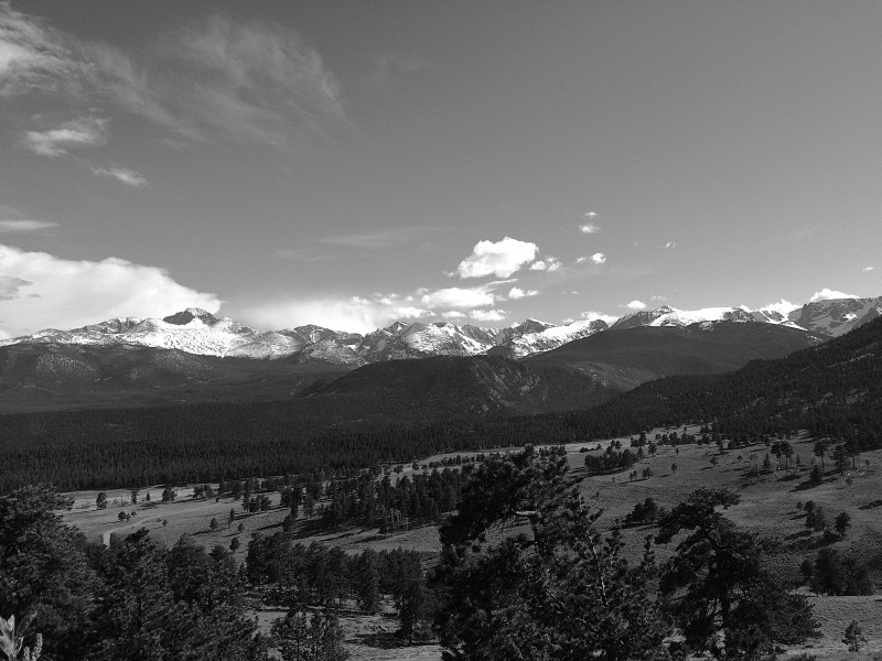 The best part of the hike up to the Keyhole in the dark was seeing all the stars outshine the lights of Longmont, Boulder and Denver 5,000 feet below. The galactic disk wasn't up high enough to see, but more stars than are ever visible from Boulder were up. Tayler and I compared our favorite constellations/areas in the sky (my favorite constellation is Orion- lots of good stuff happening with Betelgeuse and in the nebula in the belt) and told Laura a few tidbits about red supergiants and bright stars. Once we broke the treeline the headlamps on the lone, long switchback up to Granite Pass were surreal. Somehow the sky dotted with stars, the nondescript black mass of Mt. Lady Washington and the lamps slowly drifting up the trail compressed the distance among all three- it looked like the horizon was right on top of us. The hour it took us to go from the treeline to the Boulderfield was the most unique experience I've had on a 14er. Being in alpine environments is immensely more enjoyable when there is no wind. I've come to associate wind with a generally shitty experience in the outdoors-growing up in Wyoming, when the wind comes up it isn't a nice little breeze, it's a gale that just makes everything miserable. I was well aware of Longs' reputation as the state's highest wind tunnel, so I was immensely surprised (and relieved!) when we got to the Boulderfield, and then the Keyhole, and not a single breath of wind stirred the air. When we crossed through the Keyhole it was even calmer on the other side.   The Keyhole and beyond was not at all what I was expecting. My worries from May were unfounded and I felt a bit foolish for spending so much time reading trip reports and thinking "Hmmm, I hope I don't lose my mind on the Narrows." I cautiously led our group across the Ledges. We hit every route marker and the traversing was mostly class 2- the summit slabs on Bear Peak are harder than most of the moves on this section (although this could be due solely to Bear Peak being an absolute madhouse of people every time I'm on it. I once saw, in 40 degrees and socked in fog, a guy stagger up the last few slabs with an enormous backpack on, stop, take it off and proceed to pour about a gallon and a half of perfectly good water out of a container and onto the rock below. Without a doubt the strangest scene I have ever witnessed on a summit anywhere.). The exposure is definitely present, and moving too quickly or slipping on some scree would result in a tumble, but it would actually take some effort to simply fall off the mountain. The Trough was even easier. Despite the smooth rock and exposure to our backs, all three of us just humped right up the center of it and never had any problems. It's steep, but not much worse than anything else I've done. Tayler moved very quickly through here and left Laura and me a few tens of feet below.  I got to the top of the Trough, took a left and was confronted with a vertical block of rock. I didn't see Tayler but I figured she was nearby, waiting for us to catch up. A quick call out and she responded, just out of sight around the corner. I jumped up to the top of the block, hiked over to a ledge right next to the wall and stood next to her, looking out at the immense void in front of us. Now this is some exposure. The Narrows are indeed narrow. Wild Basin unfolded 2,500 feet below, the Indian Peaks jutted up to the south and, way in the distance, we could see Grays, Torreys, Evans and Bierstadt. There was still no wind at all.  Laura soon joined us, and we took a few moments to drink, rest and discuss the next section. Tayler said she didn't want to lead it, so I did. By now I was very comfortable with the rock and had no issue just dashing along on the edge of the ledges. I found that staying right (on the way up) was better footing because we weren't dealing with the awkward dirt path between ankle-level slabs, and we didn't have to duck around the over-sloping slabs right next to us. The far ledges certainly upped the exposure, but I kept a sure pace and always made sure Tayler and Laura were aware of any odd rocks or steps. A short push up the Homestretch and we were on top. I didn't realize the top of the Homestretch was so close to the southeastern corner of the summit- I thought it came up the back, or closer to the southwest side. Not so. We popped out on top, took a few steps forward and realized that continuing straight would lead us through a notch, into the air and swiftly down the southern side of the Diamond. Hey, that rock looks good! Let's sit there. We spent almost 30 minutes on top, by far the longest I've stayed on top of a 14er. It was still completely calm and the views were tremendous.  As it turns out, I didn't make it over to the very western or northern edges of the summit. I'll have to do that the next time I'm up here- I want to see what Glacier Gorge looks like from this vantage point and I want to see what the top of the Cables route looks like on the north face. Ah well. More incentive to come back to the summit, hopefully by a different route! We split the Keyhole to the summit in about an hour flat, and took 1:20 or so going back down. The Homestretch was a combination of steep 3-point hiking and a few crab-walk moves over the slickest parts of the rock. The Narrows went quickly and we soon found ourselves at the top of the Trough, eyeing the many (many) people now on their way up. I again led this part, and it took a fair amount of time to get down to the bottom. I elected to stay to the right (north-northeast) side of the gully to avoid moving any rocks down onto the people coming up the center-southwest side of the Trough. We slowly picked our way down from ledge to ledge, occasionally backtracking or pausing to search for a suitable route. Laura and Tayler diverged slightly from me at times to find downclimbs or hops that were a little shorter, since they're not quite as tall as me. Once we reached the bottom it was just an easy traverse across the Ledges back to the Keyhole, where we stopped once again. I think the hardest part of the descent may have been the tedious boulder hopping down from the Keyhole- I kept drifting off to the right and the damn trail never got any closer. The rest of the hike down to the car wasn't quite the "death march" that it's usually characterized as, but it was certainly long. Longs is long. This is where running the trail would help greatly. This is one of the only 14ers I'd like to repeat in the near future- La Plata is probably the only other one I'd like to redo right now. Longs has far too many routes, or combinations of routes, to just do the Keyhole route and call it good. I am far away from being able to do anything on the Diamond or channel my inner Anton Krupicka and climb 5.not-so-easy on Kiener's or the Cables in running shoes, but I'd like to slowly gain some more skill and experience on more vertical rock. It was a great outing on a great mountain. 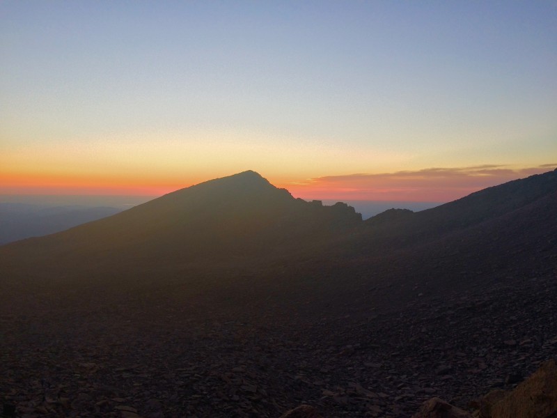 Two days after summitting Longs, as I was planning out the next weekend's outing, I decided I wanted to do it again. This time I would run between the trailhead and the Keyhole and perhaps move a bit quicker on the upper reaches of the peak. However, my plan ultimately failed to materialize. The weather was fairly damp and cold all week, and reports of snow on the upper route were popping up on the online forums. Hmm. Cold and wind I could handle, snow and ice not so much. By Thursday the 18th I had to make a call, so I decided to forego Longs and instead do an enormous run in Glacier Gorge that was essentially running to every reasonably accessible lake in the entire gorge by linking them up with every trail in the gorge. A few visits to the internet, a few perusals of various trip reports (including another by Anton, this time of the Glacier Gorge traverse- not helpful for my tamer plan to stay on the valley floor, but an engaging read anyway. This guy moves with a speed and level of confidence that is just astounding) and I was convinced this would be a good substitute for getting back up Longs. I made a GPS track on my Suunto training log- it said about 19 miles and over a vertical mile of elevation gain. Yikes. 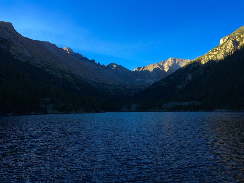 This was my 4th really long mountain run of the summer. I did the High Lonesome Loop twice and a link-up of Pawnee Pass, Pawnee Peak and Mt. Toll, all of which were a few miles shorter than this outing. The primary thought I had after doing my loop of Glacier Gorge was this: high alpine lakes are hard to get to because they are way the hell up and back in the middle of nowhere. Mills, Jewel and Black Lakes appeared in short order but Frozen Lake was a completely different affair. The ascent from Black Lake was naturally separated into two parts- a steep rock staircase next to a waterfall above Black Lake and an off-trail traverse/ascent of the tundra and rock slabs below Frozen Lake. The trail disappeared fairly quickly and I hopped from rock to rock, heading up towards the slabs below the Spearhead. I eventually found myself a bit too far to the northwest of the optimal route up the slabs. No worries, I can just traverse across them. I did this, and realized that the slabs were actually steeper than I thought. I had to climb up a 15-foot crack at one point. At the top of this slab, I was met with....more slabs. Hmmm. Where the hell is this lake? I was now on the west side of the Spearhead and all I could see was more rock unfolding ahead of me. I checked my watch and saw that the waypoint marking the lake on my route navigation was right ahead. Okay, if the GPS says so. I crested another rock and there was the lake, about 50 feet below. After a few more hops from rock to rock I was at the lake. Descending from Frozen Lake was just as much of a project as getting to it. I picked a better line through the first set of slabs but then ended up "cliffed" out (really more like ledged out, about 20 feet above the next area of flat boulders and tundra) and had to do downclimb a thin crack on one of the slabs. A few wrong turns into some willows, some scouting for cairns and I was soon back on the actual trail headed down to Black Lake. 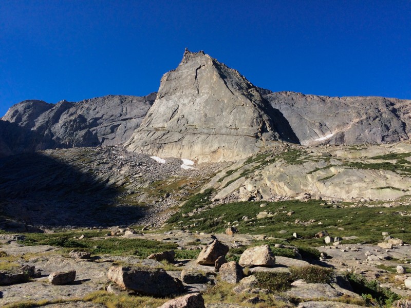 About 5 miles and over an hour later, I was trudging up the trail from The Loch to the Lake of Glass, thinking much the same thing about how hidden and inaccessible these lakes are. I came around a corner and saw the trail ended abruptly at a creek cascading down some large boulders. Where now? A quick glance to the right revealed the trail in fact did not end, just turned and headed straight up a set of ledges/steps that were part of a waterfall. Given the steepness of the rock and the fair amount of water running down the center of it, this was certainly a class 3 section. I had to wait a few moments for a hiker in front of me to get up to the top while trying to wield his trekking poles. As one might expect, he was making an absolute mess of the ascent, poles skittering all over the place and feet slipping constantly. I am not sure why he insisted on using the poles- a much better idea would have been to throw them up to the top of the shelf, javelin-style, and then retrieve them when he got up there. I climbed the section quickly and staggered onward to the Lake of Glass. By this point, 14 miles and 4 hours into my run, my legs were starting to hurt and I was really hoping the remaining 4 lakes in my loop were not quite as isolated as this one. 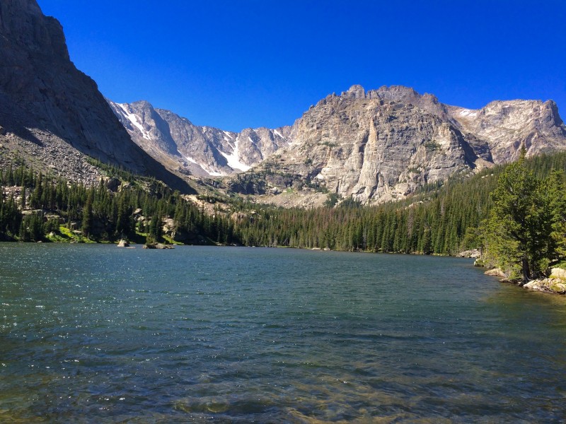  Fortunately, the remaining spurs to Lake Haiyaha, Dream Lake, Emerald Lake and Nymph Lake were the easiest trails of the day (apart from the crowds of people) and I was able to end the day with some actual running instead of hiking or boulder hopping. My actual totals ended up at 19.6 miles and about 4,800 feet of elevation gain. I may not make it back to RMNP before the snow falls this year. I would like to summit Longs one more time in September, but early snow/ice or other hikes/runs/rollerskis may push it to next year. I would also like to eventually make it back to Glacier Gorge, hopefully when I have some of the skill and experience needed to start getting up on the spires and ridges rather than just looking up at them. Regardless of how the fall schedule ends up, I'm satisfied with my summer outings in the park. Thumbnails for uploaded photos (click to open slideshow):
|
| Comments or Questions |
|---|
|
|
Caution: The information contained in this report may not be accurate and should not be the only resource used in preparation for your climb. Failure to have the necessary experience, physical conditioning, supplies or equipment can result in injury or death. 14ers.com and the author(s) of this report provide no warranties, either express or implied, that the information provided is accurate or reliable. By using the information provided, you agree to indemnify and hold harmless 14ers.com and the report author(s) with respect to any claims and demands against them, including any attorney fees and expenses. Please read the 14ers.com Safety and Disclaimer pages for more information.
Please respect private property: 14ers.com supports the rights of private landowners to determine how and by whom their land will be used. In Colorado, it is your responsibility to determine if land is private and to obtain the appropriate permission before entering the property.


