| Report Type | Full |
| Peak(s) |
Mt. Stuart - 9415 Dragontail Peak - 8842 |
| Date Posted | 08/30/2016 |
| Modified | 08/31/2016 |
| Date Climbed | 08/13/2016 |
| Author | scramble |
| A Week in the Enchantments, Central Cascades, WA |
|---|
Mt. Stuart: Direct North Ridge w/ Great Gendarme (IV, 5.9, 3000', lost count of pitches)Partner: Brian O'Callahan Ground support crew: Jan & Tom O'Callahan (does this change the grade to A0??) Beta: Selected Climbs in the Cascades Vol. I, Nelson & Potterfield; Cascade Alpine Guide Vol. I, Beckey; Steph Abegg's website (this is my third trip to the Cascades where this website has been an invaluable resource... I don't know you Steph, but THANK YOU!) We had spent the past month debating logistics and whether or not we were up for the route, one of the 50 Classic Climbs of North America. The upper north ridge is already listed at 18 pitches and 2000' of climbing. However, accessing the upper north ridge requires glacier travel and carrying crampons and ice axes. The full north ridge adds another 1000 feet of climbing with additional 5.8/5.8/5.9+ pitches, but you don't have to carry snow gear. It seemed unlikely that we could do either option as a day trip at our pace. Additionally, the easiest/most-straightforward descent down the Cascadian Couloir drops you off on the opposite side of the mountain range and at a different trailhead. There is no non-technical descent that returns you to the base of the route, so you have to carry all of your bivy gear over. In April my grandmother died, then 3 days later my dad was suddenly dead too, at age 53. It was a difficult spring, exacerbated by some dramatic characters and the stress of my brother and me (both in our mid-twenties) now being responsible for 3 properties and a business. Between flights to the east coast, psychological fallout, and both trying to finish our Ph.D.s in physics, Brian and I had still managed to squeeze in a couple of alpine climbs. I was psyched out, frequently pictured dying in graphic detail, and had acquired a new fear of exposure. Still, I remembered that hiking out after we did the Saber was the first time I had felt normal in months. Before everything happened, Brian and I had been planning on a summer rock climbing trip, and had settled on the Cascades so we could stay with his parents near Seattle. I decided we should still go, but I thought that we agreed that Stuart was too much, and there were plenty of other rocks we could climb. The week we were supposed to leave, I had just returned from a particularly disheartening trip where I had to stay alone in the house my dad died in, frantically completing yard work and home repairs so we could sell the house. I had painful tendonitis in both wrists, probably from swinging a mallet poorly, trying to compact asphalt to repair the driveway. A few days before the trip, I picked up a grapefruit in the grocery store and pain shot down both wrists.   Of course then Brian said, "I've been looking at Stuart some more. I think we should do it. The full north ridge." I said I would try, then quickly got excited about how light we could go and how much pizza we could bring. We decided to sleep on top of the rope, under a single light sleeping bag, with an emergency blanket on top. I modified the emergency blanket packaging to make it more accurate. Our last night in Boulder before the trip, I decided to go to the climbing gym and see how it felt. My wrists felt ok, but I was falling off everything, and not feeling great about climbing. Meanwhile, Brian was trying to convince me to move the climb up a day because of weather. I was like no way am I going to fly into Seattle at 10 pm tomorrow, go straight to the trailhead, climb on no sleep, get no sleep on our shiver bivy, then climb 2000 more feet. We sat in the BRC lobby and checked the forecast one more time. Indeed, a storm system was going to come in and stay around for 3-4 days. Soon we were on the phone with Southwest, pushed our flight up to the morning, and both rushed home to finish packing, because suddenly we were leaving in 10 hours! We texted our buddy, "whoops, can we actually borrow your #6 like, uh, now?" Due to the last-minute change, we actually flew to Seattle through Sacremento. The flight from Sacremento to Seattle passed by all the famous volcanic features (you want to sit on the right hand side of the plane): Crater Lake, North and South Sister, Hood, Adams, and finally Rainier, which always looks huge. Then we crammed into rush hour public transportation and arrived at Brian's childhood home in Mercer Island, just across a bridge from Seattle. I was disappointed not to find any Nickelback posters in his old room. We had enough time to grocery shop, borrow some gear from Brian's parents, have a nice family dinner, and get to bed by a reasonable hour. So much easier to do everything when you get to stay in a super nice house! Brian also convinced his parents to move the car we were borrowing from our starting trailhead Mountaineer Creek/Stuart Lake/Colchuck Lake to our ending trailhead Teanaway Road/Lake Ingalls/Longs Pass. This was awesome and saved us having to circumnavigate the mountain to get back to the car. We left Mercer Island around 5, picked up a couple of Enchantments through-hikers who needed a ride between trailheads, and started hiking at 8 am, which felt kind of late. We followed the approach beta from Nelson & Potterfield, which was perfect. At "the first switchback" they mention, the main trail switchbacks to the right, and there is a cairn which points to a climber's trail to the left. The terrain was tedious at times, with trees and boulder-hopping. When N&P say "traverse across benches," we think they mean "the trail disappears; wander through logs until you pick it up again. It was hot, so we each went through 2L of water pretty fast and stopped to refill twice. The last running water was just at treeline, when you can see the remaining approach over talus/scree to the ridge. We tried to drink as much water as possible, because we were planning on starting the climb with 2 L of water each, and we were a little nervous, having never before done an overnight trip on limited water.  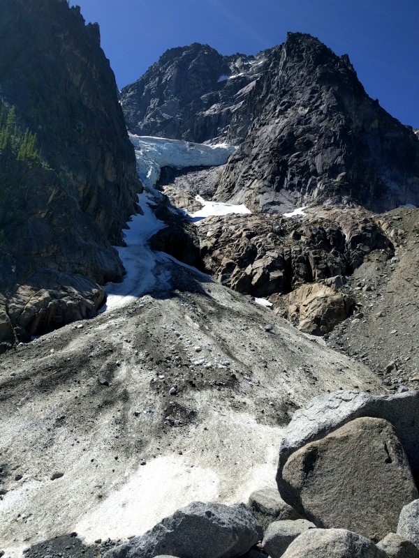 Gear: - 60m 9.5 rope - 16 alpine draws - C4/X4 camalots #0.1 to #4 (oooo offwidth!), doubles of 0.3-0.75. In retrospect, ditching the extra #1 and #2 was kinda silly. - Each carried 2L water and our own food, with a leader pack and follower pack, own mid-weight puffies and hardshells - Leader pack had extra: personal locator beacon, light sleeping bag, space blanket, my cap-4 long underwear bottoms because I was worried I would sleep cold (was a good idea), both pairs of trailrunners - Brian wished he brought a t-shirt. I liked my new zip-off pants. - Iodine tablets, headlamps, climbing tape, etc - Sleeping mask and earplugs... the Ice Cliff Glacier often made explosion sounds With the extra water (and poop) stops, it took us 5 hours to reach the base of the climb, somewhat longer than expected. (I'm not the fastest hiker.) The route looked a bit intimidating. It was to be our first time lead climbing with packs and our first time sleeping on the route. Many questions floated in our heads. Did we bring enough food? We do like our snacks. Are we going to be able to sleep at all? I thought of the hardest sandbagged Layton Kor FA "5.9+" routes and wondered if I could lead the p3 9+ pitch with an additional 10 lbs on my back. The photos here http://www.stephabegg.com/home/tripreports/washington/northcascades/stuart were useful for locating the start of the lower north ridge, and we broke up the pitches the same way (not how mountain project says). We racked up before the class 3 scramble, followed the party ahead of us, decided they were off route, then I started up pitch 1, the "awkward 5.8 slot, harder with pack." We both had slings pre-attached so we could drag the packs behind us just in case. That ended up being pretty useful. I had never lead climbed dragging a pack before, but it actually worked out ok. I found the 5.7 bit before the slot a bit harder, or maybe I was just shaky starting out, but it felt a bit balancy to me. Once I got to the "belay nook" as Beckey calls it, I wished I had brought an extra #1 and #2 for the anchor, but I overcammed a #3 and found some other stuff. Brian took the next pitch of fun 5.7 face climbing. Finally, since I have small hands, I did the 5.9+ small hands/lieback pitch, which was as beautiful as any crack I've seen, occasionally pumpy and occasionally technical, but really not too bad and super fun crack climbing! I continued after that until rope drag stopped me, and I was hoping we could get to the "5.6 and easier" simulclimbing part. We folded the rope in half, because rope drag is always bad on a low-angle ridge and it seemed like a good way to shorten the rope without having to carry the unused bit. Unfortunately, we had to do a bit more of what felt like 5.7-5.8 climbing until we got to easier terrain, resulting in some extra belays. Not a lot of beta for that part, so unclear if there was an easier way, or if what feels like 5.6 to some, feels a bit harder to us. Eventually, we found some 4th and low-5th class terrain and started moving more quickly. We had only ever done ~400 ft of simulclimbing together, approaching the base of a climb once, where the beta was plentiful and the routefinding easy. Most of my simulclimbing experience has been on glaciers/snow, where it makes sense to put the heavier person in front on the uphill (if there is a big weight difference), so I suggested that Brian go first. In retrospect, the rope drag was generally kind of bad, and the beta slim/nonexistent for parts, so although the second has to be more worried about the consequences of a fall, the leader must deal with all of the rope drag and route-finding - something I hadn't considered from my limited experience. Brian did a heroic job, though this additional burden wore on him a bit. With the 2 pm climbing start and taking time for routefinding and extra belays, I began to worry that everything was going to take longer than expected that day, and we really should have started earlier. However, at 7:05 pm, the terrain flattened and we reached two good bivy sites, right next to each other. 7 pm was our goal since the sun set at 8, so we were pretty psyched to be on schedule! We read in a trip report that the notch (where the 4th class ramp system from the glacier if doing the upper ridge meets the direct ridge) was the location of the last "good" bivy sites, so we stopped there. We had also read of a less desireable bivy site at the bottom of the Great Gendarme, but we wanted the best chance of sleeping and didn't want to climb that far anyway. In fact, the next day we found other good bivy sites at another flat place a few hundred feet of 4th to low-5th climbing away from the first two bivy sites. We couldn't see a full 4th-class route from the glacier from either of these locations, and it was unclear which was actually "THE notch." I carefully laid out the rope, zig-zagging it back and forth, to make a two-person sleeping pad. Brian was skeptical at first, but I insisted that it worked well when my weight-conscious partner did it last summer on another technical carry-over, Ptarmigan Ridge on Rainier. I think he is a believer now! Then we unzipped the sleeping bag and put it over the two of us, put the space blanket on top of that, and kind of tucked it in underneath us on the sides. Brian was smart to put rocks on his side of the space blanket. I should have done that too, because it kept blowing over during the night, and I kept waking up cold and fixing it temporarily, too groggy to realize that I should put rocks on my side too. We sat in bed, eating dinner, two fatties contemplating our dwindling pizza supplies. Given weight considerations, we didn't bring as much food as we wanted to. We were like "drinking a lot of water is a good way to feel more full, oh waaaait....." Nevertheless, a couple pieces of pizza and a bunch of fritos seemed to be sufficient, though not the huge hamburgers and beer I felt we deserved! We enjoyed the sunset and views all the way to Glacier Peak and beyond to the pointy North Cascades, and got to bed around 8:30, with the alarm set for 5:30. When the blanket wasn't blowing off, we were reasonably warm (it was supposed to be a low in the 40's), and I believe we got some sleep. It was surprising that our legs/feet were what was most uncomfortable... something about having to keep them too straight without a sleeping pad. We also kept playing footsie for the bottom part of the unzipped mummy bag. Overall, I think we chose the right system for the occasion. We saw others with much larger packs. It was simpler to go light and not have to haul on the harder pitches.    There was plenty of light by 5:30. We could have started earlier I guess, but we lazy and my fingies get cold sometimes. Around 6:30 we were off simulclimbing up 4th and easy-5th class terrain for a while. Brian did a great job routefinding despite the limited beta (no detailed topos like we are used to!). Then the terrain got steeper and more exposed. I think N&P call some of this part "mid-5th" and some parts were difficult enough to warrant belays. We mostly stayed close to the ridge proper, a few times dropping to ledge systems to the left to avoid some harder 5th class terrain. It all blended together and went on for a while, until we came to the unmistakeable "slab with crack" pitch, which was easily simulclimbed. Brian ran out of gear just after this and belayed. Then we belayed one long 60 m + (a bit of simulclimbing on some exposed but easy traversing) pitch to reach the base of the Great Gendarme. 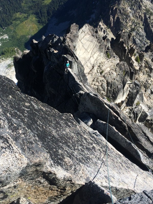 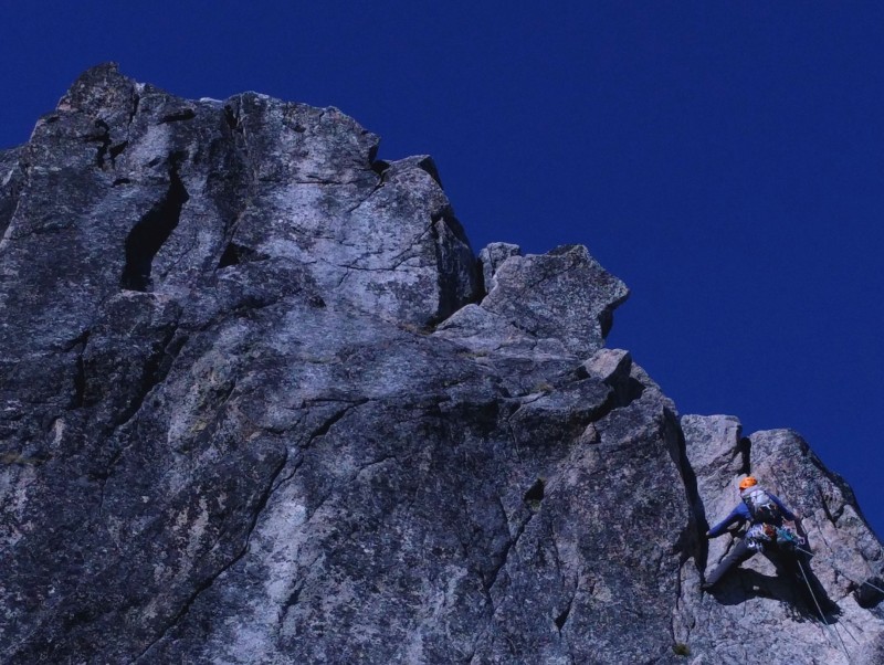   Here, two really nice guys from Minnesota who were doing the upper North Ridge (with two huge packs with crampons, ice axes, probably full bivy gear, which they had to haul) let us pass. I wondered if doing the full North Ridge was really any harder than having to carry the extra gear. I got P1 of the Great Gendarme, a 5.9 fingers to small-hands lieback, which looked like a granite Wavy Gravy. Another perfect crack pitch! It was steep at times, but the face was quite featured, with ample feet. Apparently you can do the whole thing with a 60 m, but with a perfect belay ledge in the middle, most parties seem to split it in two. Brian got the 5.9 offwidth, which I found to be burly. There is a fixed #4 that seemed to be re-slung (??), but it is nice to bring your own #4 and walk it up. There are decent fists in the back, though I had to really stick out my thumb knuckle and make my #1-sized hands as big as they could get! From that belay, I led off, trying to find "easy 5th-class, on or right of the ridge proper" that was supposed to lead to a "5.7-5.8 hand crack." I went for a while on the ridge, but found lots of rope drag and something that looked harder than easy-5th. I eventually backtracked, then down-climbed a 4th to low-5th dirty lichen ledge system to a dirty rocky gully that led to a pretty fun hand crack. I don't know if that was right. There were a couple of rap anchors from the ridge proper down into the gully I downclimbed into, so it seemed that other people also found the ridge proper too difficult and rapped down to the crack I found. Again, not sure if that was right, didn't have photos or detailed topo of that part. It worked, but oh god the rope drag. I belayed at the top of the crack. It took all 60 m. Brian then led off. We simulclimbed with 60 m between us until Brian reached the top of the difficulties and belayed me up. This worked out well, because I got to be on belay for a few moves that felt 5.7-5.8 to me. From here, it was a short walk to the summit, which we reached at 3:30 pm. With all of our fears and unknowns, we were stoked to be there! We could actually sleep on a route, take two packs, and make it to the top!  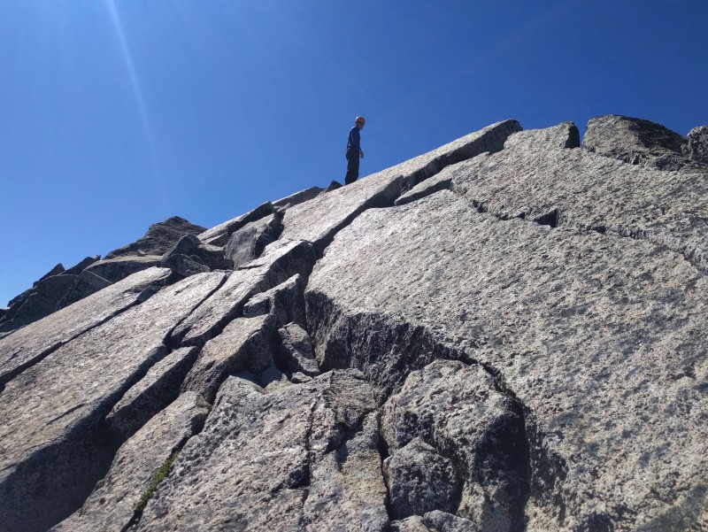 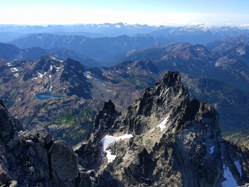 Here, Beckey's pictures of the south side of the mountain were particularly helpful for visualizing the descent route. I love books from the Mountaineers because you can also get a PDF which is really convenient for printing pages. We did not follow N&P's descent beta which called for downclimbing a 5.0 step. Instead, we followed the well-cairned 3rd-class traverse over to the false summit. From here, the route down to the Cascadian Couloir is pretty obvious, with a bit of a trail and cairns. There was a ~20 ft bit of snow to downclimb, but there were good steps already kicked, so with a sharp rock used as an ice axe and some careful stepping, it was manageable. For the part of the descent that was above treeline, the terrain was loose but not terrible, though it was difficult not to knock rocks on parties below. Below treeline, we kept losing the trail, went down a completely loose dusty wash, and eventually gave up and started bushwacking straight downhill, because we knew we would intersect a trail at the bottom of the valley. We had met a group of women near the summit who were clean, happy, and chipper. We kept asking, "Where is the trail that they took up?? The bushwacking seemed to go on forever, and it was a huge relief to finally reach a trail! We turned right, and after a bit, ran into a group of West Ridge climbers we had met at the summit, and again some other climbers. "Aw man, we really screwed up the descent, totally lost the trail," we said. The other climbers informed us that around treeline, the clear trail splits off into many trails, all terrible. "I've taken a different trail every time," one climber said. Odd, because our beta didn't mention the chaos below treeline. Perhaps being concerned that you are off-route on the descent is a Stuart first-timer hazing ritual. The not-dusty-stinky-scratched-and-filthy group of women must have just been a bunch of badasses. We enjoyed the camaraderie of fellow climbers, all also super tired. A couple other West Ridge folks asked us about the North Ridge, and we told them about the excellent crack climbing pitches. They asked, "how did you do on food?" I replied triumphantly that I had brought exactly the right amount, as I had just run out. The last part of our journey would require ascending ~1000 ft from the valley over Longs Pass before descending to the trailhead. The two guys replied, "Well, we have these summer sausage and cheese wraps that we really don't want to carry over Longs Pass... would you be interested in taking a load off?" FUCK YEAH. It was dinner time and it was so excellent to not hike up the pass on a growling stomach. One of them even offered us some hot miso soup, which I now believe to be the Elixir of Life. We hopped on the Longs Pass trail. After two days of routefinding and climbers' trails, I was very pleased that we were on an actual trail with an actual sign. We had achieved our goal of being on a legit trail by dark! I was real slow going up the pass, just steadily, slowly, putting one foot in front of the other. The two guys who fed us passed us, then waited for us at the top, which was really nice of them. It was pretty easy to stay on the trail, though. After descending the other side for a bit, you arrive at a junction with the trail that goes to Lake Ingalls, and you must take a left to return to the car. This map was useful: http://images.summitpost.org/original/864234.jpg. Finally at 11 pm, we saw some shiny-looking man-made objects in the glow of our headlamps... CARS!!! Even better, we found our car! Brian's parents had moved it to the same place where we ended! It felt magical, like in the Apollo 13 movie when they describe the difficulty of space missions as something like trying to hit a softball with a golfball. Even better, they left us fresh pretzels from a German bakery in Leavenworth, a ridiculous old mining town that was reborn into Disney-like fake Bavaria. Unlimited pretzels, sausage, and beer in the closest town to the Stuart-Enchantments area? I'm ok with it! After the steep 7000 ft descent, we got right into the car without stretching and sat for 2 hours. With a few exceptions, we had spent the previous fall/winter/spring doing a lot of sport climbing and other things with short approaches. So... we couldn't walk for the next 3 days Snow Creek Wall: Outer Space (III, 5.9, 500', 6 pitches)Partner: Brian Beta: Mountain Project was sufficient and better than the "Leavenworth Rock" guidebook On the last of our "rest" days before the next big climb, we woke up early to arrive at the Leavenworth Ranger Station at 7 am, when we thought it opened. There you could enter the daily 7:45 am lottery for a backcountry permit in the Enchantment Permit Area. We were really hoping to score a permit for Colchuck Lake for our climb of Dragontail Peak, which would split our climb up into a chill 3 day backpack where we would camp in a luxurious TENT! None of the employees showed up until around 7:45, but I was still glad we were able to arrive early to mill around, gain the sympathies of the other permit-seekers, and tell them how we flew ALL the way from Colorado to do this one dream climb, and we soooo dreamed of a permit for Colchuck Lake. Well, actually I was trying to strategically make alliances so we could maybe group together on the same permit if we lost the lottery, but the ranger later said that starting this year, they no longer allow this. However, it was still fortunate that we conversed with others, because when the ranger went around and made every party declare which zone they would like to enter the lottery for, everyone else kindly opted NOT to choose Colchuck Lake (including one super nice couple who maybe wanted to go there!) . They give one permit per zone per day, so we were thrilled to be the only ones entering the lottery for one of the most popular destinations! You must get (and pay for) a permit for N days, starting on the day when you show up in person. We paid for an extra day, intending to do the approach tomorrow. (We later learned from rangers at the lake that this technically is not allowed. You're actually supposed to enter on the day your permit says you enter. Oops. They weren't too concerned. But yes the rangers DO check permits.)   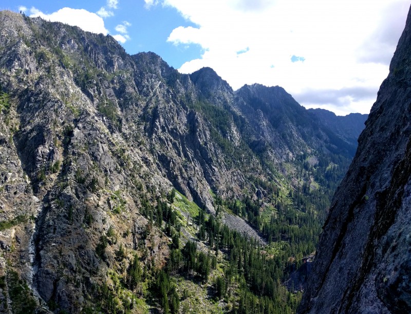 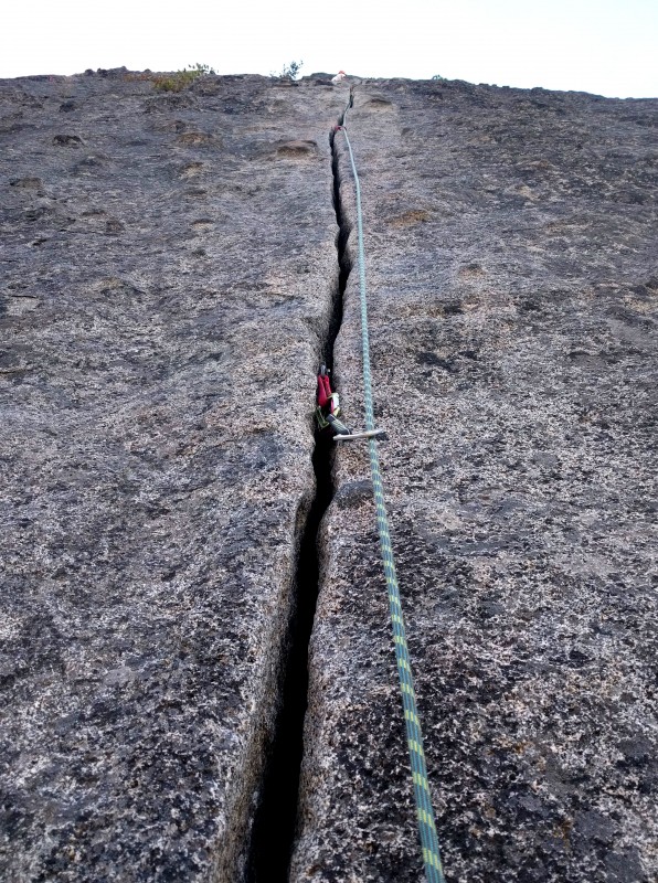 We then got a nice breakfast at one of the many Leavenworth Waffle Hauses. (For the rest of this trip report, "w" is now pronounced "v," and liberal use of umlauts should be assümed.) Browsing through the guidebook and mountain project over breakfast, we cajoled each other into climbing the super-classic Outer Space on Snow Creek Wall. Mountain project says to park at the "Snow Creek Wall" parking lot and take the "Snow Creek Trail," but I think it's actually the "Snow Lake Trailhead" and the "Snow Lake Trail." Easy enough to figure out. The approach took 1-1.5 hours or so? It was easy to find the log crossing. After the first two pitches, which we simulclimbed in one pitch, the next 4 pitches were stellar and packed a little of everything that is fun to climb: cranking on steep jugs, stemming in dihedrals, jamming splitter handcracks, and face climbing on huge chickenheads. No wonder it's a classic! Because it's so classic, it's also pretty crowded, even on a weekday. We got stuck behind a slow party and had to wait a full hour on one of the belay ledges. We played car games to pass the time. I'm going on a trip, and I'm going to bring: apples, Brian, cookies, dicks, eggs, french fries, gummy bears, Hannah (the dog!), ice cream, juice, kangaroos, llamas, money, Oops! All Berries Captain Crunch, pens, the queen, rabbits, Sara, tangerines, umbrellas, vendettas, walruses, x, yams, zephyrs. Yes we got to "z." I can't remember "x" anymore, but it was probably xylophones. We figured oh we'll do it fast and have a late lunch in town after, so I only brought 1 thing of Shot Bloks. Given the crowds, I would recommend bringing a backpack with a nice lunch packed in it, and then you can have a picnic and not be grumpy. Afterwards, we slammed down lunch at the car, then immediately went out for dinner in Leavenworth. Pretzels, sausages, and 1 liter of bier each! We car-camped at the Eightmile Campground (Forest Service, $20) which had drinking water and toilets and things.  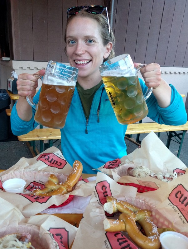 Dragontail Peak: Backbone Ridge With Fin Direct (IV+, 5.9, 2000', 15 pitches)Partner: Brian Beta: Selected Climbs in the Cascades Vol. I, Nelson & Potterfield; Cascade Alpine Guide Vol. I, Beckey; Summitpost The guidebook was a bit more intimidating for this one: "A fair amount of 5.8 and 5.9 climbing, combined with a whole lot of 4th-class and low-5th-class climbing, requires that those who choose to do this route have a high standard of free-climbing proficiency and a superior fitness level." The previous days we had wavered on whether or not we ought to do this route. Ok Brian trail runs, but I certainly do not have a "superior fitness level"!!! Also I read a trip report about somebody's partner having to build a 3:1 and haul them up the 5.9 offwidth pitch Gear: - 60m 9.5 rope - 16 alpine draws - C4/X4 camalots #0.1 to #3, #6 (a big offwidth this time!), doubles of #0.3-#2. - One 30L climbing pack. Perfect forecast, so we left our hardshells at camp, opting to just bring an emergency blanket. 3L water total for the climb. - 2 pairs microspikes, trailrunners - Iodine tablets, headlamps, climbing tape, BUG SPRAY, PLB, etc - Still love my sleeping mask and earplugs! - Big comfy tent, sleeping bags, pads, yay! - Mad food, dinner for 2 nights - Ursack and a bear canister (Little mouse friend and big goat friend at camp. The goat loved licking our pee. I guess you're supposed to pee on rocks, but then the pee runs off the rocks into the dirt and the goat digs at the dirt anyway so I dunno.) The next morning, we slept in at the campground, then went out to breakfast at Louie's Cafe in Leavenworth. Eggs benedict with tomato and avocado, so fucking good. I set a lure there and caught many Pokemon. After a stop at Safeway, we arrived at the trailhead (the same as for Mt. Stuart) and packed our things. We started up the trail and Brian realized he wanted toilet paper, so he had to run back. Maybe around 20 minutes later, Brian realized (thank goodness!) we had also forgotten our smaller climbing pack. It is good that he is a trail runner. Funny I had a gear checklist on my phone that we didn't even check. The trail felt steep with the heavy pack. Around 3 hours later, we arrived at the clear turquoise water of Colchuck Lake where we could see... gasp!... our route. Hoping to learn some lessons from Mt. Stuart, we stretched our legs, then jumped in the lake to ice them. The lake was warmer than some other alpine lakes, so I lasted a bit before my toes went numb! It felt so good to rinse off and change into clean clothes after 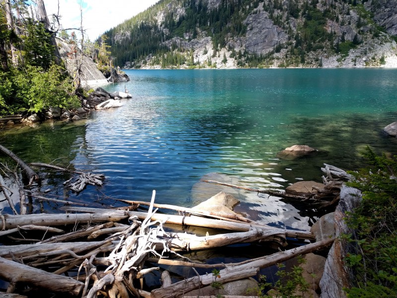  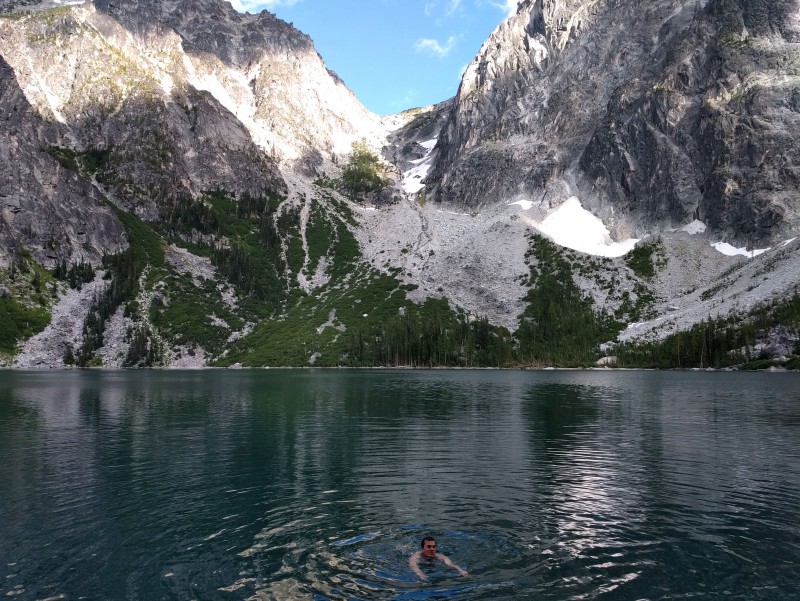 According to Nelson and Potterfield, 'When camping by the lake, it is enjoyable to sit back and watch the dramatic evening light on the big face - followed by brilliant alpenglow, a few streamers of cloud racing across the "dragontail" summit ridge of gendarmes.'    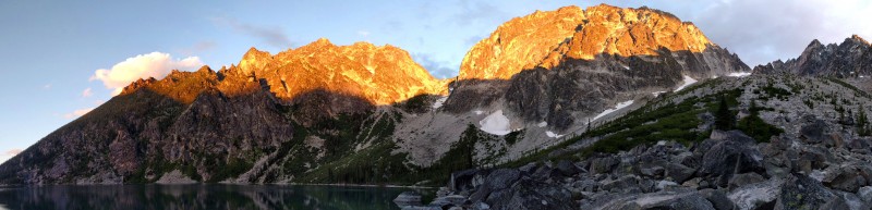 The next morning, we woke up at 3:30 and left camp at 4:50. We continued on the trail across the lake until we were staring at the big talus/scree slope that led the entrance of the ridge. this picture was particularly useful for locating the start of the ridge and following the 4th class scramble. Basically you follow the white-colored rock to the left and back to the right. Unsure of how much snow we would have to cross, the day before, we had scouted the route from the lake, and determined that we would pretty much have to cross the strip of snow at its widest point, so we each brought a pair of microspikes for the climb. We ended up putting on the microspikes and opting for the edge of the snow even before the crossing when the scree became unbearably loose. After some slogging, we saw the entrance ledge and where we needed to traverse the snow. It got a bit steep, but the suncups were convenient footholds. I used a nut tool as an ice axe and it worked nicely in the firm snow.    I always get frustrated by the variability of "4th-class" in climbing route descriptions (yelled "not 4th class!!!" down the entire East Slabs descent in Eldo...). This particular 4th-class was mellow though, and we were able to keep our trail runners on. We didn't have a photo of the first pitch, and Brian went up a chimney that seemed more ~5.8 instead of 5.6, but he soon made it to easier ground and found the base of P2, the offwidth. For this reason especially, we just brought one follower pack. We each carried wider nylon shoulder-length sling to rack on, because I'm a baby and thought Dyneema would cut into my neck too much. I felt ok without a #5 (had debated bringing it). Was able to walk the #6 up most of the way and sling a chockstone in the middle. We both climbed it clean, so perhaps lessons from our Memorial Day weekend Vedauwoo struggles came in handy. It felt easier than the 5.9 offwidths closer to home. A lot of trip reports mentioned getting off-route on the next pitches. The Summitpost description was my favorite and we generally stayed on-route. We pitched everything out, except for Summitpost's P6-10, which we simuled. We ended up doing an extra pitch for the P11-14 part. Summitpost's pitch lengths might be a bit off, because we tried to use the rope length to pick our belays, and ended up needing an extra pitch to get to the "foot shuffle crack." After that, I wandered along the ridge proper for one pitch, then Brian did a traverse to a fun dihedral for the last pitch. This deposited us just below the summit, so we apparently missed the "400 feet of loose 4th class," which was actually nice. After 15 pitches, we summited at 5 pm. I was just psyched to avoid a bivy on the route!    From the summit, we enjoyed views of Mt. Stuart, the Enchantment Lakes, Rainier, Adams, Baker, and the North Cascades. We had the mountain to ourselves all day. We followed the standard route to descend, first down a worn trail on the SW side of the mountain, then at the saddle we wrapped around skier's left and traversed NE across well-worn steps in snow slope. We were ok with just microspikes, but we were definitely extra careful not to fall, because the slope steepened just below us. Then it was much rock hopping to Aasgard Pass (labeled "Colchuck Pass" on some maps). Brian had climbed Colchuck Peak back when he lived in WA, so it was convenient to have a local expert point the way to the pass. It is good to study the map and note that the trail goes over a bit of the hill before descending. Don't turn skier's left too early. It was great to finally intersect the hiking trail. We still had a fair amount of daylight, so we enjoyed looking at water falls and goats on our way down Aasgard Pass. We reached the lake around dusk and enjoyed another dip in the water. 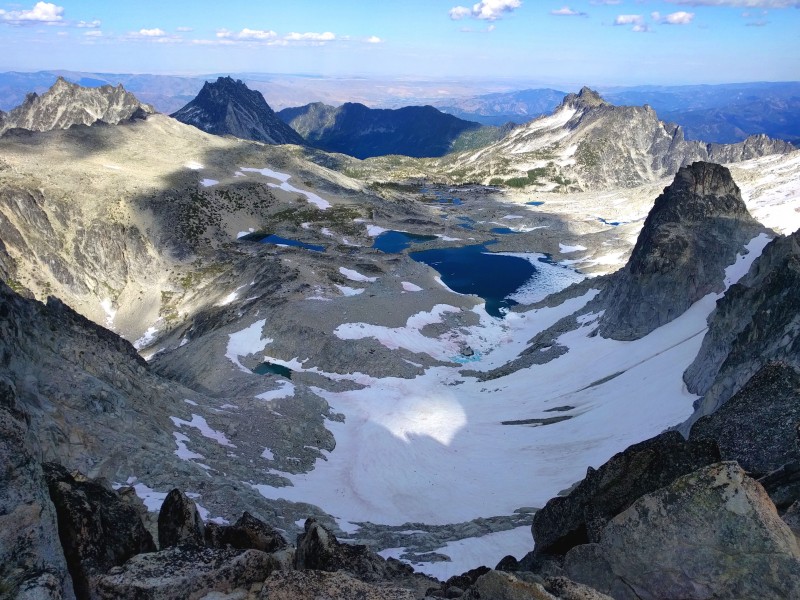   Back at camp, we devoured some freeze-dried lasagna (one of the better ones, for sure), turned of our headlamps, and watched the Perseid meteor shower. We saw one every few minutes. An awesome thick, orange one burned across the sky. With that, we settled in to bed and hiked out the next morning, after a nice sleep. ConclusionThe next day was my birthday, and I enjoyed sour beer, shrimp, steak, cake and port wine out of fancy crystal glasses with the O'Callahan family. Pretty sweet! Then I finished up this Washington trip with a solo trip to the beach. The Cascades are probably my favorite mountain range. It was my 5th summer in a row going there, and it was cool to try a more rock-focused trip for once. We were really happy with how everything went on the longest routes we have ever done. Thanks to my friends, cat, dog, ever-supportive boyfriend, and great climbing partners like Brian for getting me through a difficult time, and pushing me to succeed on routes I was scared to try.  Thumbnails for uploaded photos (click to open slideshow): ")
 Sunrise on Ice Cliff glacier")
 Looking back at me on the ridge")
 Stuart North Ridge from Dragontail summit")
 Ocean mist in the forest")
 Summit selfie")
 Brian on the ridge, with the Fin above")
 Pacific Ocean")
 Views on the approach (Stuart on right, behind pyramid-shaped hills)")
 Ice Cliff glacier moraine")
 Mountaineering is serious business. Like the internet.")
 Sunset from the bivy, featuring Glacier Peak")
 MTV Cribs: Mt. Stuart North Ridge")
 One of those surprise not-so-low-5th sections on the ridge")
 Foot traverse on the Fin")
 Pitch 15 of 15!")
 Endless simulclimbing")
 Pitch 1 of the Great Gendarme")
 Summit")
 Isabel Lake and beyond, from the summit")
 Good night mountains")
 Lakes in the enchantments")
")
 Stoked to get an Enchantments permit!!!!")
 Hills poking through clouds on the approach to Snow Creek Wall")
")
 Belay ledge views")
 The Money Pitch")
 Zwei liter bier!!!")
 I love Leavenworth.")
 Colchuck Lake is turquoise")
 View of Dragontail from Aasgard Pass")
 Peak next to Dragontail reflected in Colchuck Lake")
 Going for a swim!")
")
 A strip of sunset between clouds and ridge")
 Great campsite")
 Watching the sun race across the dragon's tail")
 Approaching, with alpenglow on Colchuck Peak")
 Colchuck Peak sunrise")
|
| Comments or Questions | |||||||||||||||
|---|---|---|---|---|---|---|---|---|---|---|---|---|---|---|---|
|
Caution: The information contained in this report may not be accurate and should not be the only resource used in preparation for your climb. Failure to have the necessary experience, physical conditioning, supplies or equipment can result in injury or death. 14ers.com and the author(s) of this report provide no warranties, either express or implied, that the information provided is accurate or reliable. By using the information provided, you agree to indemnify and hold harmless 14ers.com and the report author(s) with respect to any claims and demands against them, including any attorney fees and expenses. Please read the 14ers.com Safety and Disclaimer pages for more information.
Please respect private property: 14ers.com supports the rights of private landowners to determine how and by whom their land will be used. In Colorado, it is your responsibility to determine if land is private and to obtain the appropriate permission before entering the property.


