| Report Type | Full |
| Peak(s) |
"Crestolita" - 13,264 feet |
| Date Posted | 07/17/2016 |
| Date Climbed | 07/13/2016 |
| Author | jdorje |
| Crestolita Southwest Ridge |
|---|
As far as I can tell, there's nothing on the internet about this ridge, so I'll break tradition and jump right to the beta.
Distance: 10.1 miles Elevation gain: 4720 feet Original BetaI first conceived of hiking this route some time ago, while walking up to Cottonwood Lake. For some reason I detoured around the waterfall cliff to the left/west, all the way to the top and some hundred feet above the trail, finding myself looking back down at the cliff face at the end of the Crestolita SW ridge. From here it looked like this ledge was a fairly easy ascent to gain the ridge. I took several pictures but none really did it justice. Some quick internet searching turned up no information about the ridge. I ran the idea past a couple of Crestone locals, but didn't really get anywhere. Finally one day I made up an approximate route on Hillmap, and one morning deciding that I wanted to get out and do some running I just went off to scout it out.   Cottonwood TrailThe mosquitoes in Crestone have been bad, but are mostly past; I was not expecting much problem with them. While I did bring head netting and long pants, I only had one long sleeve undershirt and rain gear. I knew it would be hot but no rain was forecast. Not really anticipating going all the way to the top, I did this as an afternoon hike. From the start, Cottonwood had more mosquitoes than I expected. I started off in shorts and short sleeves running up the trail, but was quickly forced to convert and put on long sleeves and pants. This made it too hot to run and my progress was slowed, but I still flew up the early portions of the trail. Entering the higher section of the valley, the mosquito situation changed dramatically. Perhaps because it was now mid-afternoon, they were out in bulk and two shirts were not cutting it. I put on full hazmat suit in the form of my non-breathable lightweight raincoat to make it through the swampy portions above around 11000'. I crossed paths with the sole hiker I met on this day, a fellow descending from Crestone Peak who also expressed angst at the mosquito situation. I got lost less than I usually do on the Cottonwood trail, this time only losing my way once when I lost my confidence in my memory of the trail. Around the area where the Cottonwood and Milwaukee trails split off, the USGS topo map of the trail is inaccurate - it shows the trails separating quite a bit earlier than they actually do. But since the trail peters out around this point and you are simply following one cairn to the next, once I lost track of the cairns I found myself miserable and alone in a veritable cloud of mosquitoes. Desperate to escape the torment, I simply bushwhacked my way uphill until I met up with the trail switching back. From the point of the split up to the waterfall, things only become more miserable and impossible to follow - essentially bushwhacking from one cairn to the next. I climbed up the central gully of the waterfall, the first time I've ever remembered to find this "standard" route from below. To get here you have to walk up almost underneath the waterfall, and then follow a steep and narrow gully straight up to the rocks above the falls. It was here that I thankfully left behind the mosquitoes, and shed my hazmat suit as I headed up into the tundra. Crestolita LaneThe SW ridge of Crestolita terminates in a several hundred foot high vertical-to-overhanging cliff. This cliff is visible from below, and when lost (as I was) on the trail is the main landmark to work around. From the side it's even more impressive, making the ridge look inaccessible. But a small ledge leads from directly above the waterfall straight across to the bottom of the ridge, just above the cliff. From above the waterfall I stopped to eye the route, and it remained promising looking. I neglected to take any pictures however, as that would have required exposing my hands to the mosquitoes. The entry to the ledge is the main choke point, and is clearly visible from the waterfall. This was the point I made for, hiking up steep grass or tundra (this is just below 12000') to get there. The ledge itself is of modest width, but not exactly flat; though most or all of it would be called class 2, below it is a cliff. I'd consider the whole stretch to be a no-fall zone. It wasn't hard terrain at all, but I was very cautious and precise as I made my way across it. It was not long.  Just before the last section, I left the ledge. Rather than wrap around and follow the last section of the ledge - not visible from where I was - I decided to exit up a steep class 3+ gully. It was a solid climb, but quite steep for a few feet and still in the no-fall area. In hindsight this wasn't really a smart choice, and I'm not sure what made me think it was a good idea at the time. SW RidgeExiting the Lane, I was now on the ridge. It was 4 pm, I still had well over 1000 feet to the summit, and I was down to just a few ounces of water left - but all the mosquito agony was rewarded. Ascending the ridge was easy and the views were increasingly fantastic. A smokey haze in the distance from the Hayden Pass Fire blocked views of any other mountain ranges, but the adjacent Sangres were in beautiful summer glory. While on the top of the ridge, I was looking right at Crestone Peak and Needle while working my way up the hill. However a series of numerous false summits lead me to detour to the right (east) around them. Behind me and to my right was the Cottonwood/Milwaukee basin; looking at the ridge to the south mainly made me think these peaks were best climbed from the south. The wildflowers were excellent, and I took my time. 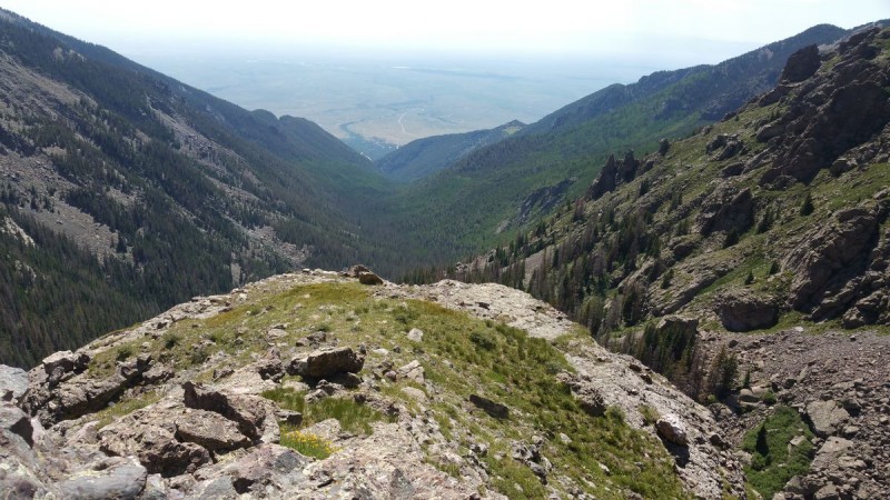      The last of the false summits looked exceedingly like an actual summit. I was convinced I was there, but on checking my GPS realized there must be another ridge behind it. So this one, too, I looped to the right on, though there was still a little scrambling as I was passing right below the (false) summit block. Pretty much all of the rock - along the ridge and summit block and even down below - was good conglomerate, so the scrambling options were good. Staying sufficiently below the ridge would avoid them completely, however. Coming around this final false summit, the true summit block was finally in view. I was focused on gaining elevation at this point, and again neglected to stop for pictures. The summit was easily recognizable because the ridge leading off to the eastern summit was finally in view. The ridge funneled up into a gully that looked like it didn't go all the way to the top of the summit block, so I detoured to the right across tundra and talus to gain the eastern ridge. From here I followed what I assume was the standard route to the summit, looping almost all the way around to scramble up the final few feet from the north. Sounds long, but the summit block was so thin that the elevation gain was more work than the horizontal distance. CrestolitaThere's not much to say about the summit except for the pictures. Nice views.    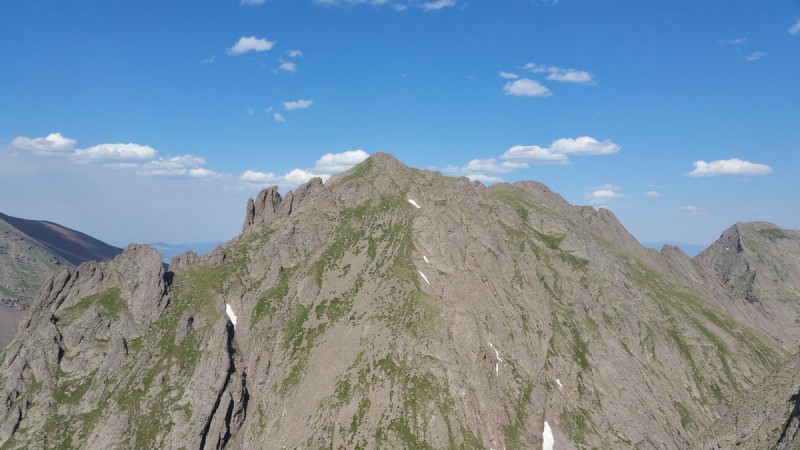  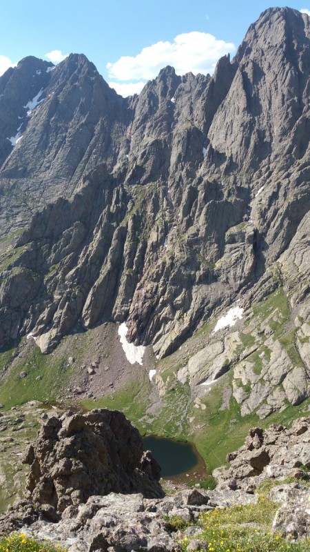 DescentFrom the summit, I could see the descent directly back to the ridge was an easy walk-down after all, so I went straight down to the south rather than descending to the north.  I followed the ridge all the way down to the top of the cliff. I knew I needed to follow the ledge precisely to get back down - or return to the summit and take the standard gully - and I didn't want to repeat the scramble I'd followed on the way up. I'd seen the entry to the ledge from here on the way up, and it was easy to find as expected. Right near the top though, there was a strange rock formation: a 5-foot descent where I needed to scramble around, under, or over a human-sized overhanging rock. It didn't look entirely stable, so I gave it a couple kicks. It immediately tumbled off, down the sloping ledge, and over the cliff to join the pile of talus a hundred feet below. This was pretty disturbing - I mindlessly screamed "rock" though I was fairly sure there was nobody else in this basin, and certainly not climbing in the talus pile below. After a few seconds of consideration I realized that pushing the rock out of the way had been the right move, and with it gone this was now an easy descent. Only a few minutes later did I realize that had I ascended that way (rather than exiting the ledge early), this same rock would have been above my head and not easy at all to get around. Still later it occurred to me that probably nobody has traveled this ledge any time recently; that rock had to have been there ready to fall for quite a while. Unfortunately with the end of the ledge came the return to misery. Rather than return to the top of the waterfall, I took the shorter direct route straight into the basin below (down from climbers right/east of the waterfall). This route would have worked fine on the ascent too, but wouldn't have given the opportunity to scout the route from a distance. So I headed straight down into the willows, hazmat suit on, and was immediately swarmed with mosquitoes. The next two hours were hell, as I alternated simply trying to stay on the cairned semi-trail while wearing full mosquito protection, then running down the trail while the mosquitoes followed, swarming. I didn't bring my water filter, and though I filled up my bottle from the creek, it didn't look great to drink. So I toughed it out to the bottom. Clearly I should have taken more water, but I didn't really expect to make it all the way to the top, nor to have to wear a non-breathable rain coat the whole way to avoid being eaten alive in 85 degree sun while doing it. But as always with dehydration, the delicious taste of water at the end made it all worth it. So it was with the mosquitoes. Though I found myself hating the Cottonwood trail yet again, the ridge route was pretty marvelously worth it. Thumbnails for uploaded photos (click to open slideshow):  Planned route: 4.45 miles, 4743-16 feet one way")
 View from across the valley of the ledge")
 Crestolita Lane - view from the top")
 Looking over the cliff back at Cottonwood Creek")
 Pt 12751 (?) and the ridge to the South")
 Upper Milwaukee Basin with Pico Aslado and (?) UN13020")
 Some Crestones")
 Looking up the ridge")
 More ridge")
 Crestones")
 Humboldt, Colony Baldy, and the Hayden fire")
 Crestone Peak and its south ridge")
 Broken Hand Peak")
 Crestolita's eastern summit, Milwaukee Peak, Pico Aislado, and more Sangres")
 Cottonwood Lake and Crestones")
 Gully & ridge to the SW")
|
| Comments or Questions | |||
|---|---|---|---|
|
Caution: The information contained in this report may not be accurate and should not be the only resource used in preparation for your climb. Failure to have the necessary experience, physical conditioning, supplies or equipment can result in injury or death. 14ers.com and the author(s) of this report provide no warranties, either express or implied, that the information provided is accurate or reliable. By using the information provided, you agree to indemnify and hold harmless 14ers.com and the report author(s) with respect to any claims and demands against them, including any attorney fees and expenses. Please read the 14ers.com Safety and Disclaimer pages for more information.
Please respect private property: 14ers.com supports the rights of private landowners to determine how and by whom their land will be used. In Colorado, it is your responsibility to determine if land is private and to obtain the appropriate permission before entering the property.


