Download Agreement, Release, and Acknowledgement of Risk:
You (the person requesting this file download) fully understand mountain climbing ("Activity") involves risks and dangers of serious bodily injury, including permanent disability, paralysis, and death ("Risks") and you fully accept and assume all such risks and all responsibility for losses, costs, and damages you incur as a result of your participation in this Activity.
You acknowledge that information in the file you have chosen to download may not be accurate and may contain errors. You agree to assume all risks when using this information and agree to release and discharge 14ers.com, 14ers Inc. and the author(s) of such information (collectively, the "Released Parties").
You hereby discharge the Released Parties from all damages, actions, claims and liabilities of any nature, specifically including, but not limited to, damages, actions, claims and liabilities arising from or related to the negligence of the Released Parties. You further agree to indemnify, hold harmless and defend 14ers.com, 14ers Inc. and each of the other Released Parties from and against any loss, damage, liability and expense, including costs and attorney fees, incurred by 14ers.com, 14ers Inc. or any of the other Released Parties as a result of you using information provided on the 14ers.com or 14ers Inc. websites.
You have read this agreement, fully understand its terms and intend it to be a complete and unconditional release of all liability to the greatest extent allowed by law and agree that if any portion of this agreement is held to be invalid the balance, notwithstanding, shall continue in full force and effect.
By clicking "OK" you agree to these terms. If you DO NOT agree, click "Cancel"...
Summary:
Min Elevation: 10,413'
Max Elevation: 13,213'
Elevation gain: 2,920'
Time to Summit: 3:36
Round Trip Time: 6:30 (including an extensive search for my boots)
Round Trip Distance: 11 miles
Ski Quality:
Approach/Egress:
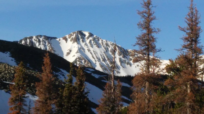
Being a ski mountaineer is like having multiple personality disorder. There is the mountaineer personality that had me climb 5,000' vert and 14 miles for a mediocre ski descent of Electric Peak, just because of the elevation of its summit. And then the next day, my other personality, the skier, says "let's go ski that sick line with the easy approach on that obscure, unranked peak that no one has heard about." Thirsty Peak accommodates my skier alter ego.
I first caught a glimpse of its glorious north face on a ski tour of nearby Cottonwood Peak the previous fall (check out the report http://14ers.com/php14ers/tripreport.php?trip=16704&cpgm=tripmine for more info on the approach). It was looking good in November, so I figured it must be good at the peak of the spring ski season.
I drove the rough road up towards Cloverdale basin, and by the time I was getting close to the lake, my nerves were getting fried. The rougher the road got and the more snow I encountered, the more I began to imagine getting stuck and having to drive backwards to a turn around point. I got to the lake as the sun was setting and said "f' it! I'm sleeping here."
The next morning, I started hiking as the sun started rising (I was thinking a 10-11 a.m. descent time would be ideal for a north face). As I hiked, all I could think about was how I could have driven what I was hiking. It seriously weighed on my mind. "God, I hope I come to an impassible snow bank, or a downed tree, or a rocky section my X-Terra couldn't handle, to justify starting the hike where I did."
After 1.2 miles (just beyond the first cabin), I came to the first snow bank that would have stopped my vehicle. I was incredibly relieved to know that I only lost about 20 minutes by not driving the road. I could finally relax and feel vindicated about my decision to park where I did. Needless to say, my jubilation was short lived as I pressed on, post holing through the unfrozen snow banks.
Now that my mind wasn't obsessively focused on the extra mileage I caused by not driving further, my thoughts turned to whether I was making good progress and if I would make the summit by 9 to 10. I also wondered if 9 to 10 was the right time to descend. I knew from the previous day's experience that this would be plenty early enough for a north face, but I began to wonder if the entire line was north facing. It appeared that way from the map and from my experience in the fall, but it occurred to me that the sun is much lower in November than it is in June and the face may not be shaded now like it was then.
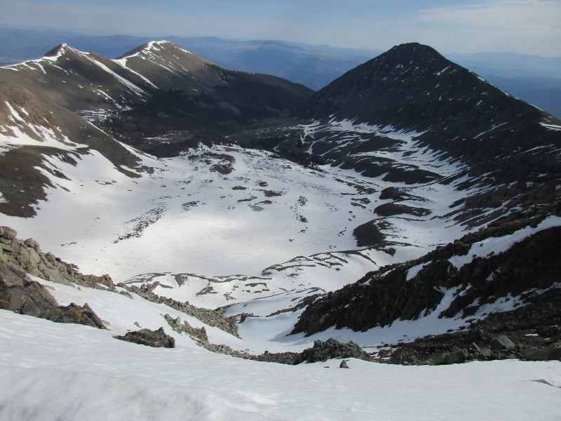
By the time I got to the cabins, around 11,000', the line came into view.
"$%&@! The entrance of the line is east facing! And it's steep!"
I knew I'd be much too late to ski a steep east facing entrance. I decided that this would have to be a beta mission, and I'd have to come back the next day earlier in the morning. I'd have to ski the entrance at a reasonable time and then ski the north face on ice. That didn't sound very good either. I pressed on.
Around 11,200', above the cabins, I encountered continuous snow and ditched my hiking boots in a tree and donned my ski boots. I made a mental note of the elevation and stuck a dead tree in the snow in the middle of the trail to make retrieval of my boots obvious.
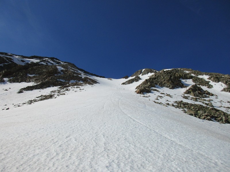
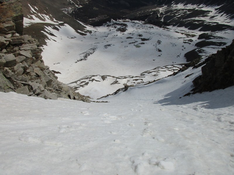
At the base of the face, I switched to crampons and booted up the couloir lookers left of the summit to the ridge. From the top of the couloir, it was an easy stroll on snow and grass to the summit.
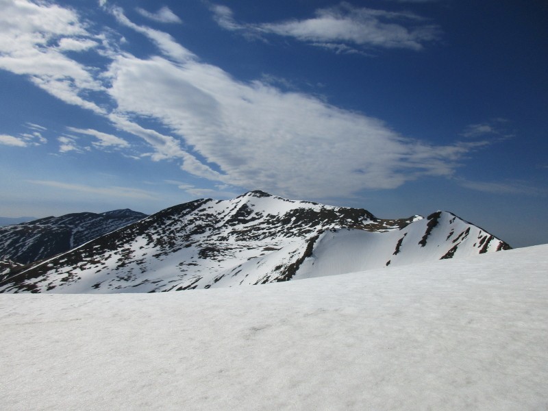
On the ridge, looking towards summit
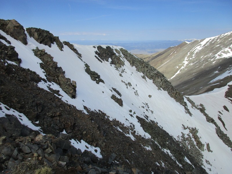
Looking south towards Lake Peak
I made the summit around 9:30 a.m., about three and a half hours from the start of the hike. After viewing the entrance of the line and testing the softness of some east facing snow on the ridge to the summit, I decided that I would drop in. I figured if I was patient and utilized all my sloughing and avy managment skill, I could make it down and across the short east facing summit to the safety of the north facing couloir.
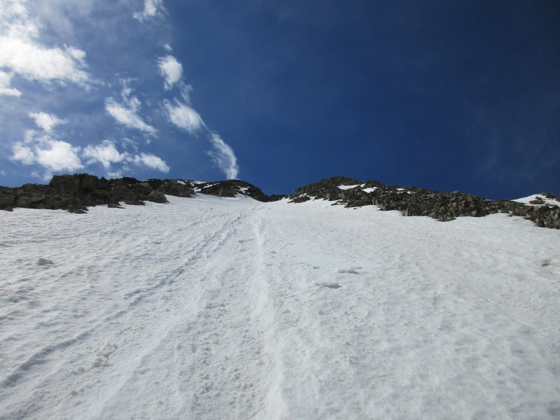
I clicked into my skis about ten feet down from the summit, at the top of the entrance seen in the previous photo. The snow was firm at the top and I was able to make a few genuine jump turns without fear of releasing a slide. After just a couple turns on this steep section, it was time to do a descending traverse to skiers left to get around the rocks. I side slipped forward and down as cautiously as I could. I intentionally put pressure on the slope to slough it out. Near the rocks, I was releasing small wet slabs that went down to the rocks below. I intentionally did this so I could edge on the rocks beneath. With a bit of patience, I was able to confidently and safely get passed the rocks and ski down into the north facing couloir.
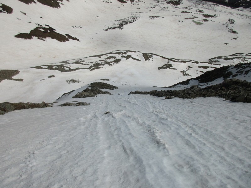
From here, I felt home free. Well, nearly home free. The snow was just starting to soften up and was perfect skiing! Thank you skier personality!
As I hiked out, I kept an eye out for the log in the snow that marked the place I stashed my boots. I also turned on the GPS and payed extra attention when I came within a hundred vertical feet of the elevation I noted (since sometimes it's off). When I reached 11,256', the elevation I noted when I left my boots, it was clear that this was not where I left them.
"That's ok" I thought to myself, "I was sure it would be off by a little bit. My boots must be lower. Could I have passed it? No, I'm sure I couldn't have missed a giant log sticking straight out of the snow. It's definitely lower."
So, I kept going down. After descending to 11,000' I knew my gps couldn't have been off by that much.
"I must have passed it. I'm not sure how I could have missed a log in the trail, but I must have passed it. Maybe I wandered off trail and around the log marker."
I ditched my pack and headed back up the trail. No sign of the boots. I kept going until I was above 11,300'. At this point, I came to a large patch of snow that I knew I wouldn't have crossed with my hiking boots.
"The boots must be lower. Maybe I just remembered the elevation incorrectly."
So, I headed back down. I kept going and going without any trace of them. I examined the up hill foot prints in the snow and tried to determine if they were ski boots or hiking boots. It was hard to tell because of the melting snow, but my best guess was they were ski boots and my hiking boots were lower.
Eventually it became obvious I had descended too low. My next plan was to get to the car, drive as high as possible, knock off that 1.2 miles, and head up the trail in my trail runners.
The only possibility I could think of is that they were higher than the high point when I retraced my steps. Perhaps I did not cross that snow patch that I assumed I did not cross, but instead went around it on a bare patch in the woods. So, I hiked up to the previous high point, only to discover my gps was now reading lower than 11,200' (lower than the stash point). I discovered a bare patch in the woods, as I predicted, and followed it. I only had to hike an additional 20 feet to notice my log marker. I couldn't believe I had given up, just twenty feet from seeing the marker.
Out of curiosity, I went above the log marker and turned towards it to see what I would have seen on the hike down, in an attempt to understand how I could have missed it. Looking at it from that perspective, it became obvious how I missed it. I immediately remembered having seen it on the way down, but didn't recognize it as the marker because there were downed trees beyond it, and I just assumed the log marker was apart of that mess.
I was glad to have retrieved my boots, but needless to say, I was feeling pretty damn special at that point. Sometimes I really amaze myself with my stupidity. As I hiked down, all I could think was "I can't wait to see what stupid thing I'll do next. Maybe I'll walk right past my car. I wonder how far below my car I will get before I notice."
Thumbnails for uploaded photos (click to open slideshow):
I didn't think i'd ever see a TR for that peak, we did the a descent of that peak back in 1998, that brought back some memories, keep up the good work!
I can't remember the route that we did, and we have no pictures or anything from that, we were camping down in that area and rafted the royal gorge the next day, the only reason I remember the peak is because we probably said "skiing thirsty peak makes you thirsty" 400 times while drinking beer afterwards.
a really gravelly side hill road, a hillbilly that emerged from the woods that said "if y'all get stuck don't come running for me", and there was a droid and like 8 cases of beer, and possibly a yeti sighting. 1998 was a long time ago, I'm surprised I remember that much.
Caution: The information contained in this report may not be accurate and should not be the only resource used in preparation for your climb. Failure to have the necessary experience, physical conditioning, supplies or equipment can result in injury or death. 14ers.com and the author(s) of this report provide no warranties, either express or implied, that the information provided is accurate or reliable. By using the information provided, you agree to indemnify and hold harmless 14ers.com and the report author(s) with respect to any claims and demands against them, including any attorney fees and expenses. Please read the 14ers.com Safety and Disclaimer pages for more information.
Please respect private property: 14ers.com supports the rights of private landowners to determine how and by whom their land will be used. In Colorado, it is your responsibility to determine if land is private and to obtain the appropriate permission before entering the property.