Download Agreement, Release, and Acknowledgement of Risk:
You (the person requesting this file download) fully understand mountain climbing ("Activity") involves risks and dangers of serious bodily injury, including permanent disability, paralysis, and death ("Risks") and you fully accept and assume all such risks and all responsibility for losses, costs, and damages you incur as a result of your participation in this Activity.
You acknowledge that information in the file you have chosen to download may not be accurate and may contain errors. You agree to assume all risks when using this information and agree to release and discharge 14ers.com, 14ers Inc. and the author(s) of such information (collectively, the "Released Parties").
You hereby discharge the Released Parties from all damages, actions, claims and liabilities of any nature, specifically including, but not limited to, damages, actions, claims and liabilities arising from or related to the negligence of the Released Parties. You further agree to indemnify, hold harmless and defend 14ers.com, 14ers Inc. and each of the other Released Parties from and against any loss, damage, liability and expense, including costs and attorney fees, incurred by 14ers.com, 14ers Inc. or any of the other Released Parties as a result of you using information provided on the 14ers.com or 14ers Inc. websites.
You have read this agreement, fully understand its terms and intend it to be a complete and unconditional release of all liability to the greatest extent allowed by law and agree that if any portion of this agreement is held to be invalid the balance, notwithstanding, shall continue in full force and effect.
By clicking "OK" you agree to these terms. If you DO NOT agree, click "Cancel"...
The idea started just like every other mountaineering trip starts, just two guys sitting around throwing around ideas and mountaineering goals until you both just look at each other with that look of "why not? Lets do it!". A few months ago my friend and I, Bobalob, decided that a new challenge was in order. Last summer he completed all the Colorado 14ers and I was through 34 so we decided to think outside the great state of Colorado, the first peak that popped into our minds was Denali. But after some realization that starting with that peak as our first glacier experience probably wasn't the greatest idea so we took it down a notch and started looking at routes on Mt. Rainier. Similar to our peak selection we started off by looking at our max skill level and started training for Liberty Ridge, but we realized we needed to get some additional ice climbing experience before breaking off that big of a bite. So we set our sights on the Emmons/Winthrop glacier, the biggest glacier in the continental US, and started training. Anyone who is looking to get into glacier travel, Loveland Valley is great place to practice crevasse rescue when the slopes are closed!
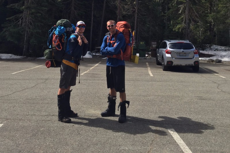
Time flew and before we knew it we were on a plane heading towards Seattle. We learned that packing for trips outside of Colorado is a lot more difficult than just throwing a bunch of stuff in your trunk and heading out. We landed in Seattle Friday night about 1230 and luckily had a place to stay and a car to use thanks to a mutual connection in Seattle. We left for the mountain in the morning, trying to get to the Ranger station early enough to leave no doubt about obtaining a climbing permit. If you are lucky enough to have clear weather heading to the park you will have some breathtaking views of Mt. Rainier and get a sense of how it just towers over the surrounding area, sadly we were not this lucky on the way in. We got our climbing permit with no questions asked and plenty of availability remaining and set out on the trail about 1030 Starting off with plenty of excitement.
The hike into our high camp, Camp Schurman 9,400ft, was only 6 miles but had an elevation gain of 5,000 ft. The first 3 miles were on easy dirt trail and some snow covered trail with minimal elevation gain. Along this trail you get some glimpses of the upper mountain and they are incredible, they were truly picturesque. Couldn't have imagined a more impressive view from the trees
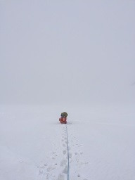
We reached treeline and the end of the trail feeling great about ourselves and thinking we could make it to Camp Schurman by 2 or 2:30 without a problem. Boy were we wrong! The clouds had settled over the valley so we couldn't really see the extent of the "hill" that were about to go up.
It would not end
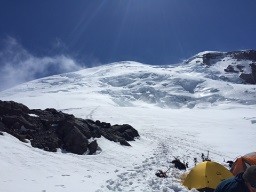
We caught up with some groups ahead of us on the interglacier and started following them up until we all gained the ridge and realized we had overshot the correct route by a good half mile to the right. Looking back at the maps, our route took us up to St. Elmos pass and then we traversed the ridgeline back to the center and correct area of the interglacier. From here it was one of the longest slogs up a slope I have ever endured in my life. It was later in the afternoon and even with the cloud cover the snow was very soft and I ended up setting the boot pack for my partner and the rest of the teams behind us...have never been more frustrated! We finally rallied into Camp Schurman around 4:30 and quickly set up our snow platform so we could sneak some zzz's in the tent before dinner. Camp Schurman and what looks like a quick easy route to the Summit...it's not
The weather had never looked good for Saturday and Sunday and after speaking with the Rangers at Camp Schurman, shout out to Rangers Cam and Scotty for being awesome, we quickly decided to take a day to rest and not try and summit with 40 mph winds on the upper mountain and 60's on the summit. If you decide to tackle Rainier I would highly suggest planning on taking a day at high camp and just enjoying the atmosphere and the views that this amazing mountain has to offer. We just hung around camp on Sunday and took a quick walk to stretch the legs getting about 1,200ft above camp. We spoke with the Rangers later on Sunday and decided that with the early season temps and the winds that we didn't have to worry too much about the snow conditions and decided sleep in compared to most other groups and head out around 5am.
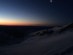
I was like a kid on Christmas morning the next day just waiting for my alarm to go off to signal the start of summit day! After a quick apple and crunchy granola bar my partner and I were roped up and heading out of camp. The creeping first light
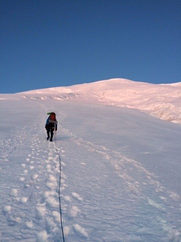
There were a number of groups ahead of us, which made for a pretty cool sight of little lights heading up the mountain as the sun poked its head up. We made pretty good time heading up the mountain, the route description calls for a max of 30-35 degree slope and by that they mean a constant 30-35 degree slope, get your calves ready for a LONG day! How many steps to get up 5,000ft? A lot
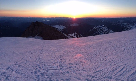
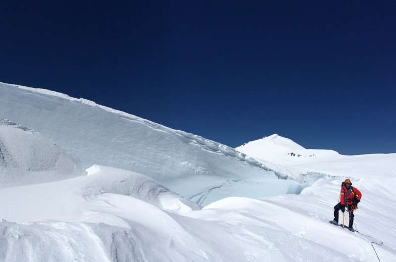
We came across our first crevasse a little up the mountain, it was only a foot or so wide but stepping across it and looking down to a dark abyss was definitely a wake up call that this mountain was different than we had ever done before. Sunrise from the glacierThe lower mountain was pretty straightforward with little crevasse hoppings and easy snow bridges. Once we passed the final group and became the lead group of the remaining mountain was when the real experience started. We had to navigate a large Bergschrund at the top which consisted of scaling a 45-50 degree snow bridge and then side stepping another larger crevasse at the top of the bridge. The Bergschrund and deep crevasses
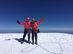
After that it was just a heads down hike up the remaining 500-750ft or so of elevation. Similar to the previous days the summit was quite a spectacle of wind so we only ended up staying for 5-10 minutes, our phones froze and shut off within minutes due to the windchill. Overall the ascent only took us approx. 5hrs. It was quite a cold summit
Once we got out of the wind a little below the summit we jet boiled up some water and had some down right delicious hot chocolate, I cannot think of a better summit drink! Obligatory Hot Chocolate picture
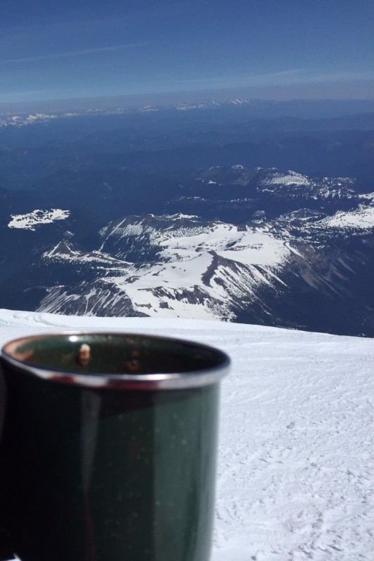
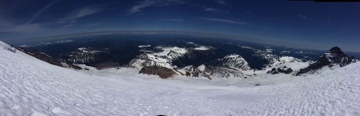
Heading down the mountain is where you get a sense of just how steep, prolonged and massive the route actually was. The route gains 5,000ft in a little over 3 miles so it is definitely a sustained slope. But the views all the way down are breathtaking, it seems like you can see the entire west coast from the top of this peak.View of the whole world from the Glacier
On the way down we had our first and only fatality of the trip...Bobs mitten. While putting his summit mittens back on his harness a mitten slipped off the biner and fell onto the slope. We both have never felt more helpless just watching as the glove slowly picked up speed down the slope before disappearing into the blue abyss that are these crevasses. It was funny to look back on but also served as a reminder how little control that you have on a mountain like this.
After a long descent of side stepping and plunge stepping we made it back to camp a little before 2 and we began to revel in the experience that we just had. Although this mountain is no bigger than those we have here in Colorado it definitely is a whole new animal and a great stepping stone in my mountaineering career. We stayed the night at Camp Schurman before heading out the following morning. The "hill" that I had cursed over and over on the ascent on Saturday was the same one I couldn't stop smiling on as we were able to glissade a good 1-1.5 miles and descend at least 2,500ft. The descent from Camp Schurman took us a little under 3 hours and just like that we were back in the car heading to Seattle, taking a whole new respect for mountains with us.
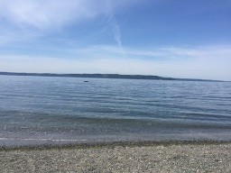
After reading some other trip reports we had to make the trip straight to the ocean to take a quick dip. Nothing like going from 14,400 ft to -1 ft in under a day! A nice refreshing, quite cold, dip
Thumbnails for uploaded photos (click to open slideshow):
Excellent trip report and pictures. Congratulations on summiting! Also thanks for the beta, my team will be climbing the Emmons route in early July and it's good to get an idea of the conditions this year.
Awesome report. We summited via the DC on 6/3 a few days after you. Amazing mountain.
Caution: The information contained in this report may not be accurate and should not be the only resource used in preparation for your climb. Failure to have the necessary experience, physical conditioning, supplies or equipment can result in injury or death. 14ers.com and the author(s) of this report provide no warranties, either express or implied, that the information provided is accurate or reliable. By using the information provided, you agree to indemnify and hold harmless 14ers.com and the report author(s) with respect to any claims and demands against them, including any attorney fees and expenses. Please read the 14ers.com Safety and Disclaimer pages for more information.
Please respect private property: 14ers.com supports the rights of private landowners to determine how and by whom their land will be used. In Colorado, it is your responsibility to determine if land is private and to obtain the appropriate permission before entering the property.

 Little Tahoma Peak just hanging out")