Download Agreement, Release, and Acknowledgement of Risk:
You (the person requesting this file download) fully understand mountain climbing ("Activity") involves risks and dangers of serious bodily injury, including permanent disability, paralysis, and death ("Risks") and you fully accept and assume all such risks and all responsibility for losses, costs, and damages you incur as a result of your participation in this Activity.
You acknowledge that information in the file you have chosen to download may not be accurate and may contain errors. You agree to assume all risks when using this information and agree to release and discharge 14ers.com, 14ers Inc. and the author(s) of such information (collectively, the "Released Parties").
You hereby discharge the Released Parties from all damages, actions, claims and liabilities of any nature, specifically including, but not limited to, damages, actions, claims and liabilities arising from or related to the negligence of the Released Parties. You further agree to indemnify, hold harmless and defend 14ers.com, 14ers Inc. and each of the other Released Parties from and against any loss, damage, liability and expense, including costs and attorney fees, incurred by 14ers.com, 14ers Inc. or any of the other Released Parties as a result of you using information provided on the 14ers.com or 14ers Inc. websites.
You have read this agreement, fully understand its terms and intend it to be a complete and unconditional release of all liability to the greatest extent allowed by law and agree that if any portion of this agreement is held to be invalid the balance, notwithstanding, shall continue in full force and effect.
By clicking "OK" you agree to these terms. If you DO NOT agree, click "Cancel"...
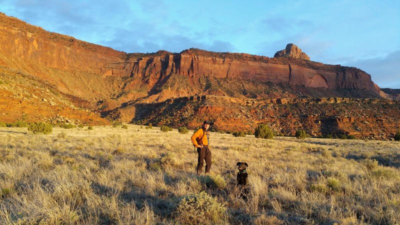
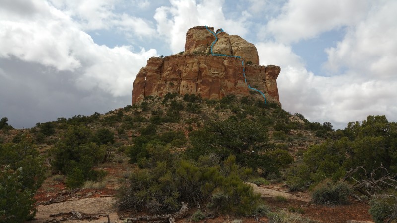
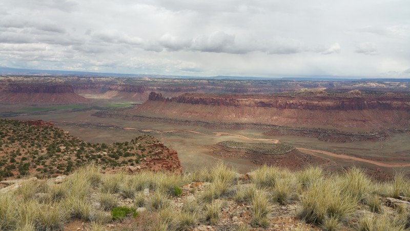
Lavender Butte at sunset. Almost the entire route is visible. We started left of series of outside corners.
In March of 2014, my friend Randy I and made a peakbagging outing to the Canyonlands. High on our ticklist was Lavender Butte (aka Lavender 2 Benchmark). In the decades we'd been climbing in Indian Creek, we'd spent much time around the impressive Lavender formation, a four mile long mesa with 400' Wingate cliffs below the mesa and a summit tower that was at least 200' high, but it was terra incognito as far climbing was concerned, unmentioned in any of the guides we used or by habitues of the area, so we joined everyone else in ignoring it. Now that our primary objective was summiting and not cragging, as the highest and most prominent peak in the area, Lavender became a must do. In our preparations, we had found no beta on climbing it or even records of ascents. Maps and satellite photos showed no obvious non-technical way to the summit, but since it had a USGS benchmark on top, we assumed there had to be one. Randy and I ended up spending the better part of a day driving the rough roads that parallel both sides of the mesa but found no weakness through the Wingate layer that wouldn't entail three to four pitches of Indian Creek style crack climbing while the summit tower remained a mystery (though its white Navajo sandstone promised a choss fest.) Conceding that ropes and a serious rack would be required, two areas offered the most hope for relatively easy passage. The NE end had stepped cliffs which might provide a series of short pitches if each cliff had a climbable crack through it; this approach, fraught with potential show stoppers, had the additional disadvantage that it would leave us two miles from the summit. The other feasible option was a basin on the west side, only half a mile from the top, containing a series of tree-covered ramps could likely be connected with a couple of 50' 5.9ish pitches. Having anticipated a 3rd class romp, we were mentally unprepared for the amount of effort required to get to the summit, so we put Lavender on the "future considerations" list and ended up salvaging the day by doing the first ascent of the smaller formation to Lavender's west which we dubbed "Consolation Butte." Subsequent internet research revealed that the USGS the party that placed the benchmark had reached the summit by helicopter. This lead to the exciting conclusion that the most significant summit in the premier crack climbing destination in the world was possibly unclimbed. Lavender thus became a compelling rock climbing objective that we kept to ourselves lest some more motivated (and better) rock climbers beat us to the FA.
In March of this year, I happened to have dinner at the home of Ralph and Eve, a Moab couple who have ascended more than 550 and 350 5th class Canyonlands towers respectively. We compared notes on various obscurities but I was most curious to see what they had to say about Lavender. It turned out that Ralph had climbed it twice, once getting onto the mesa by a 4 pitch 5.11 route on the east side and once via a 5.9 line up the west side weakness Randy and I had identified. Both times he had climbed the summit tower from the north side via surprisingly moderate climbing. He provided me a topo of the summit tower and the south side start, but no specifics about the north side start. While some might have been disappointed at missing out on a first ascent, I was glad to have some beta and to know that a bolt kit and an enormous rack would not be required.
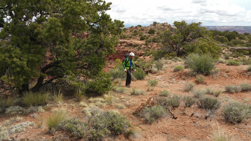
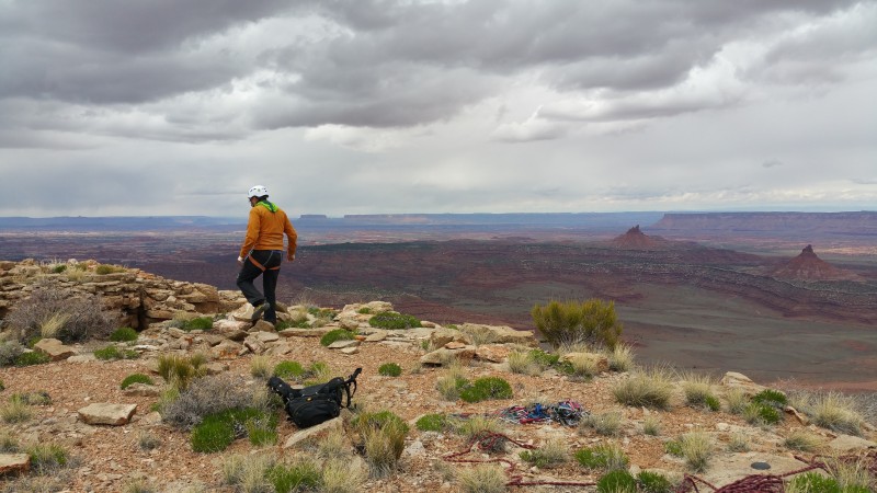
In late April of this year, Randy and I once again found ourselves on another adventure trip on the Colorado Plateau. After some fun outings, we ended up in Cortez on a Monday, waiting out some weather. While the forecast for Indian Creek was generally unfavorable, with rain Tuesday and Thursday, Wednesday looked OK. Tuesday morning we drove from Cortez to IC, encountering intermittent rain and occasional snow. Once in IC, we took the surprisingly good road up that runs south down Davis Canyon and parked about 2 miles N of Lavender's summit amid intermittent rain showers. Our plan was to carry gear up to the base and maybe make an armed reconnaissance of the 5th class climbing if conditions permitted. After a couple of hours of waiting for showers to pass, sitting in the truck and eating potato chips, we had descended sufficiently far into lethargy that the idea of putting together a rack, much less slogging it up the rugged escarpment seemed too much to contemplate so when it finally stopped raining it was all we could do to start walking toward the base armed with only binoculars. After half a mile, it resumed raining hard enough that we went back to the car. After that squall passed we set up camp and put together a rack. By about six, the skies were clear enough and we were bored enough that that we rallied for the haul to the base. The approach took about an hour and the going wasn't too bad except for some side hilling on steep, wet Bentonic mudstone.
On the approach
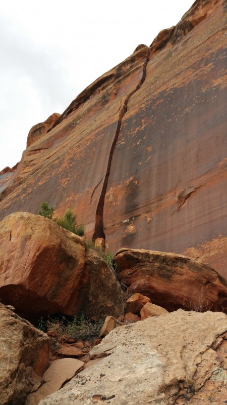
As we got close enough to discern individual features, it became apparent that the there were many climbable lines through the Wingate layer. Most of these were on the steep walls adjacent to our destination weakness, but one ran right up the middle of it. We hoped against hope that this 90' crack would turn out to be hand sized -- easy and fun -- and not something wider requiring lots of wide, heavy gear and slow exhausting climbing. It turned out to be some of both, the first third was tantalizing hands but from there it widened until by the top it appeared to be in the wide offwidth to squeeze chimney range. Though this crack was quite aesthetic and promised a high-quality climbing experience, it seemed like it would get us off to a slow start and require hauling a lot more gear to the base, so we punted and traversed the base looking for a more expeditious line. We soon encountered what was likely the most splitter chimney I'd ever seen, clean sided and very parallel but at three feet wide with no visible protection, the experience it promised seemed too exhilarating by half. We kept traversing passing by progressively less mega 5th class options until we came to a broken-up indirect weakness with no inherent appeal except for ease of passage. So, full of its-the-smart-thing-to-do rationalizations, we bypassed all the high-quality options and decided we would start the ascent with a chossy scrambling line.
The start of the route with the 2nd pitch foreshortened Direct start splitter, avoided by us
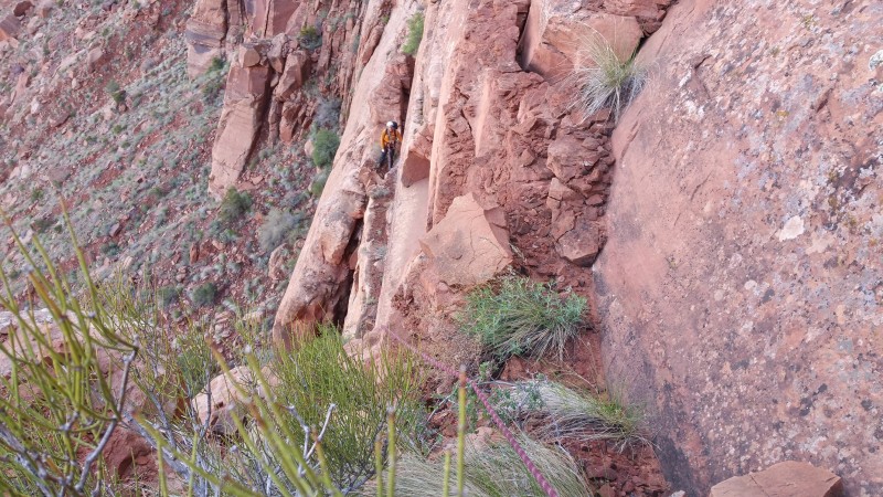
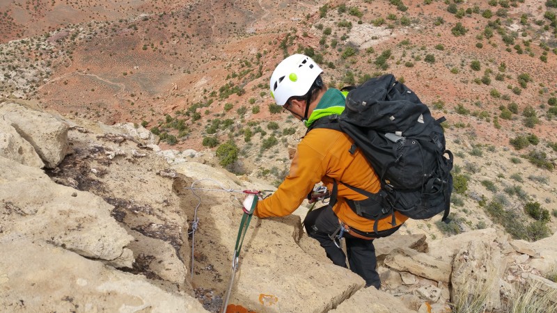
Pitch 1: ~30' class 2 traverse right. ~40' up and left on class 3 and 4 and easy 5th with a couple of pieces of pro. 40'class 3 traverse straight right with a piece about 1/3 of the through to protect the second. ~30' of low angle, 5-6" crack, low 5th class. For its last 5', this crack steepens and a crux is encountered exiting the crack. When we did it, the crack was topped by two chockstones. The first one didn't seem to be attached by much but felt solid. The second was very loose. I used the lower chockstone for pro and handholds and it stayed put. Getting around the chockstones with wet, slippery, lichen-covered and muddy footholds felt about 5.8. The exit handhold above the crux was very loose. I belayed soon after the crux, near the left end of a long ledge, using dubious hand sized cams in a dirt-filled slot. When Randy followed the pitch the lower crux chockstone came loose and it was all he could do to keep it from falling on him. The exit handhold broke off entirely. The crux felt about 5.8 to me but the rating is likely to change since two of the key holds are either gone or unusable; on the other hand, drier rock should improve the footing.
Pitch 1
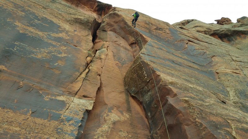
We had hoped to continue straight up just to the right of the belay through a broken-up, roofy looking area but this section seemed to have no protection so we traversed right, perhaps 100' to the end of the ledge where there were some cracks. We decided to have a go at the left most crack, a heavily lichened low-angle hand and finger crack up a ramp.
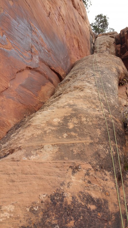
Pitch 2: This pitch would be a very popular easy pitch if it were on one of the more accessible IC crags. Consistent, easy crack climbing on solid rock, it was really the only climbing on the route that would conform to normal rock climbing standards of quality. After about 80' there is a tree with a rap sling and 'biner. After the tree about 100' of class 3 leads to a ledge where we belayed. The pitch was about 5.7 and 180'.
Most of pitch 2
A the belay, we unroped and changed back into approach shoes. About 5 minutes of class 2 with a couple of 3rd class moves got us onto the mesa whence it was a pleasant half mile walk across a land that time forgot to the base of the summit tower.
Action photo: walking across the mesa North side of summit tower
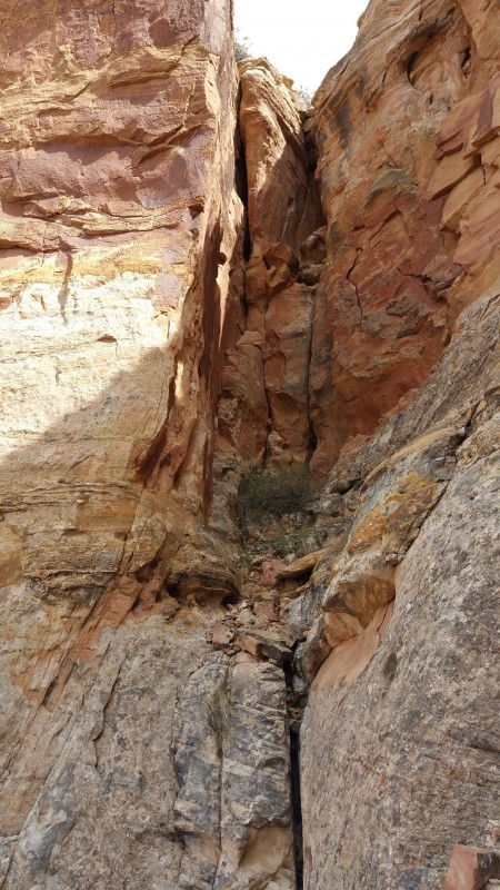
The summit tower started with about 50' of class 4 scrambling up to a ledge. From the left side of the ledge, inset behind a pillar, we climbed a 20', 5.8ish hand crack, followed by some easier ground and then a 15', too-narrow-for-helmets chimney. This pitch had questionable rock (par for the course) but good gear wherever it was wanted. The pitch ended on a gravelly ledge with no placements for gear. I walked to the far (east) side of the ledge, sat down and made a body weight belay with the rope running over a slight rise between my position and the end of the pitch. Randy followed the chimney by removing the pack and attaching it to a couple of full-length runners which were chained to his harness.
There was a tree with a rap anchor on the other side of the chimney from my belay.
Squeeze chimney and preceding crack
From the belay we walked left/SW to the base of a gully.
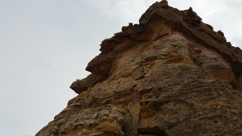
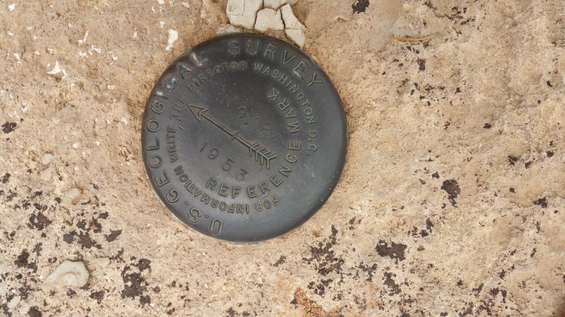
The gully was about 50' of class 3 to the notch between the two summits which contained some USGS survey detritus. We didn't know which summit was higher so I headed toward the south/left one on easy ground and poor rock. About 2/3 of the way to the top, after a #1 (red) Tricam placement, the climbing seemed harder, runout friction climbing with too much damp lichen on the foot smears for my tastes. I downclimbed to the Tricam while Randy moved the belay up to the notch. I traversed left a few feet from the Tricam and then went up more comfortably to the cap rock. The cap rock layer, possibly limestone, was the best on the route, hard and very prickly. After a couple of moves, I was on the top. ~50', 5.4R.
Most of the last pitch
We spent some time enjoying the summit views -- it's not too often one looks down on the Sixshooters. We found no anchor, so we tied a strand of 5mm perlon around some unattached blocks and rappeled from it. After a single rap, the cord was alarmingly abraded where it had rubbed against the rough rock. The next party to use this anchor should plan on replacing it or at least backing it up for which about 20' of cord or webbing would be required.
A 50' rap put us back at the notch. The scramble to the north summit has one CL 4 move. The two summits are very close in height and we couldn't determine which was higher. There are benchmarks on both.
From the north summit, we down climbed and walked to the anchor tree at the top of the squeeze chimney. From this anchor, a 100' rap and a few feet of downclimbing put us back in walking territory.
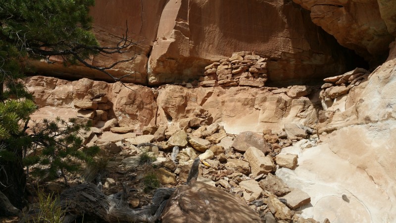
With a fair amount of time left in the day, we decided to explore the west end of the tower and some of that side of the mesa. As Ralph had intimated, there are some ruins, presumably Anasazi, on the west side of the summit tower. One wonders how its constructors got on the mesa, how they subsisted up there and why. If we'd had more time we would have walked all the way to the west end of the mesa, but wanted to leave plenty of time for the descent and its unknowns.
South side of summit tower Ruins at the base of the south side of summit tower Training for Lavender Butte?
The descent went as smoothly as could be hoped for. From the end of the last pitch below the mesa, we downclimbed to the tree with the rap anchor. From here it was about 70' down to the big ledge. At the ledge, we rigged an anchor from which it was 95' to the ground. You could probably make it to the ground from the tree anchor with a 200' rap; breaking this up into two raps gave two very clean rope pulls. For reference sake, our lowest rap anchor is about 50' to climber's right of the top of the nice looking splitter / direct start.
Car to car the climb took about eleven hours. For me, it felt more like mountaineering than rock climbing as the climb consisted mostly of class two, three and four interspersed with class five pitches. One would definitely add some quality by doing the direct start.
Randy on the east summit with the Sixshooters in the background Benchmark on east summit Bridge Jack from the summit, with Fin, Cat and Reservoir walls in the background Summit rap Final rap
Gear: We had a double set of Camalots from .3 to #3, 1 #4 Camalot, 2 #5 Camalots, 1 #6 Camalot; 1 #3 Big Bro; 1 set Tri Cams from .5 to #3; a single set of Wild Country Rocks from #1 to # 8. We could have made do without the following: the nuts, though I placed the 2 smallest exiting the squeeze chimney; the Tri Cams except for the #1; the second #5 Camalot.
We had two 60 meter ropes though one stayed in the pack until the last rappel where it turned out it was not needed.
For the direct start, without having climbed it or having had a definitive view of the upper 60', I would want at least the following: Camalots: 2 x #1, 2 x #2, 4 x #3, 2 x #4, 2 x #5, 2 x #6. 1 #3 Big Bro.
YMMV. This is an adventurous route that covers a lot of ground and had a lot of poor rock. The two key holds of what was for us the crux are gone.
Partial GPS track. Through some combination of Android, Samsung and/or Backcountry Navigator glitches, BCN repeatedly shut down without saving the track.
My GPS Tracks on Google Maps (made from a .GPX file upload):
Really enjoyed this report, Dave, looks like it was a fun puzzle to solve. Interesting that there were ruins up that high, very impressive that they could climb up there without Stealth rubber! :lol: I'm certainly not an expert on that era, but I think (?) I vaguely recall a theory that the Anasazi out-migration may have been caused, at least in part, by external factors. Maybe those ruins were part of a watchtower system. Anyway, great report, congrats.
Looks like your cup of tea! Chossy adventuring. Very interesting about the ruins up high. I feel like I read a report about some high up moki steps in the Grand Canyon that were a sort of mystery as to how they got up there. Maybe some leather on your climbing shoes is the way to go?
Perhaps those ruins were a sort of Vision Quest because the solo to and from alone and alive would most certainly be a rite of passage. However, this may be a more suitable modern day undertaking http://www.mountainproject.com/v/vision-quest/105717655
Hi and good report. Lavender Mesa is one of many isolated buttes and mesas on the Colorado Plateau that are undisturbed by most human activities, like livestock grazing, logging, and other impacts. They are nearly pristine with interesting, perhaps unique, ecological characteristics. Some mesas--including Lavender Mesa are BLM Areas of Critical Environmental Concern. With the dramatic interest in sandstone climbing we need to tread carefully on these sites and avoid walking on the soil crust, introducing seeds of invasive species, and otherwise impacting the natural communities.
Here is a link to several research articles that examine the ecological characteristics of isolated buttes and mesas and their importance: https://sites.google.com/site/johnsonecology/national-geographic-research
David Johnson
PS: Here is one example of ridiculous abuse of one of these natural areas (Priest and Nuns in Castle Valley): https://www.youtube.com/watch?v=MfmYCM4CS8o
Caution: The information contained in this report may not be accurate and should not be the only resource used in preparation for your climb. Failure to have the necessary experience, physical conditioning, supplies or equipment can result in injury or death. 14ers.com and the author(s) of this report provide no warranties, either express or implied, that the information provided is accurate or reliable. By using the information provided, you agree to indemnify and hold harmless 14ers.com and the report author(s) with respect to any claims and demands against them, including any attorney fees and expenses. Please read the 14ers.com Safety and Disclaimer pages for more information.
Please respect private property: 14ers.com supports the rights of private landowners to determine how and by whom their land will be used. In Colorado, it is your responsibility to determine if land is private and to obtain the appropriate permission before entering the property.