Download Agreement, Release, and Acknowledgement of Risk:
You (the person requesting this file download) fully understand mountain climbing ("Activity") involves risks and dangers of serious bodily injury, including permanent disability, paralysis, and death ("Risks") and you fully accept and assume all such risks and all responsibility for losses, costs, and damages you incur as a result of your participation in this Activity.
You acknowledge that information in the file you have chosen to download may not be accurate and may contain errors. You agree to assume all risks when using this information and agree to release and discharge 14ers.com, 14ers Inc. and the author(s) of such information (collectively, the "Released Parties").
You hereby discharge the Released Parties from all damages, actions, claims and liabilities of any nature, specifically including, but not limited to, damages, actions, claims and liabilities arising from or related to the negligence of the Released Parties. You further agree to indemnify, hold harmless and defend 14ers.com, 14ers Inc. and each of the other Released Parties from and against any loss, damage, liability and expense, including costs and attorney fees, incurred by 14ers.com, 14ers Inc. or any of the other Released Parties as a result of you using information provided on the 14ers.com or 14ers Inc. websites.
You have read this agreement, fully understand its terms and intend it to be a complete and unconditional release of all liability to the greatest extent allowed by law and agree that if any portion of this agreement is held to be invalid the balance, notwithstanding, shall continue in full force and effect.
By clicking "OK" you agree to these terms. If you DO NOT agree, click "Cancel"...
Savage Peak Northeast Ridge
Summit: 13,139 feet
Trialhead: ~10,000 feet
Elevation gain: ~3200 feet
Distance: ~8.0 miles RT
Hikers: Yours truly, plus co-workers Jordan and Melanie
Every once in a while in the summer, I'd take a look at the 13ers map to see what peaks were nearby, what sort of routes they have, etc. Savage Peak stuck out as a low 13er, standing relatively alone in the northern Sawatch between the 14ers Mount Massive and Mount of the Holy Cross. I put it on the "peaks I'd like to hike on a weekday morning before work" list and eventually planned to hike it on the morning of September 17. I invited two of my co-workers along, Melanie (from Michigan) and Jordan (from Ontario, eh?), who have both gone head-first into living the active Colorado lifestyle since coming over to Eagle County.
We set off to the trailhead from Avon at around dark o'clock in the morning, and turned onto Homestake Road from Highway 24. Homestake Road reminded me of Chaffee County 390. If you've been on that one, you understand the absolutely deplorable road quality for what should be nice dirt roads. We turned off of Homestake Road and up the other road, then turned onto the final road (you can see actual trailhead directions in the link below) for just a little bit before parking.
Savage Peak does have a route description on this site; see here.
We started off a bit lost. We weren't quite sure if we parked in the right spot, so instead of crossing the creek where we parked, we hiked up the road for about 10 minutes before determining we should have crossed the creek right away.
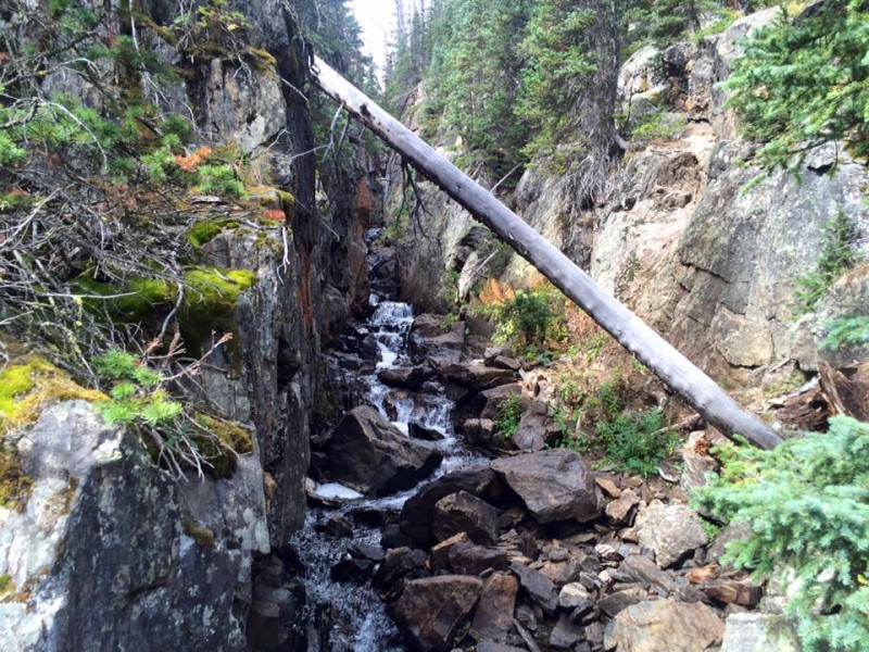
We went back down the road and crossed the creek. We then started up the hill and immediately joined up with the trail, which starts lower from the parking lot mentioned in the trailhead directions in the link above. We continued on the trail, which is actually an old road, up through the trees and to the wilderness boundary. Here, the path shrinks and becomes a normal trail. Farther up we went, and before long we got to the bridge. The bridge crossed just below what looked like a miniature canyon carved by the creek, which was a very cool thing to see.
The mini-canyon.
As the sun rose, we got closer to the Missouri Lakes area, below Savage and the other peaks to its north. The northern Sawatch is some seriously underrated terrain.
A morning view of the area.
We decided to cross the relatively flat glade at a point between two tall trees, framing Savage quite nicely. There was no social trail, so we simply walked across the grass. This was only a couple minutes' walk below the first lake, which sits at the base of Savage's north ridge.
This is the point where we began to cut across the glade toward the peak.
After crossing a couple of tiny steams and walking around isolated trees through the grass, then uphill a bit, we came to the steep slope at the base of the northeast ridge of Savage Peak. The slope was mostly grass with scattered scree, but it had quite an incline. We suffered up the slope, opting to scramble up some easy rocks at the very top toward the right (to the left, you can continue on mostly grass).
Looking north toward the upper several lakes, which are scattered in the trees and along the slope bases.
Looking northwest from near the base of the slope leading to the ridge. You can see the first lake, just left and below of ce
Savage Peak from the base of the steep slope leading up a section of its northeast ridge.
Approaching the ridge crest.
The top of the ridge at this point is still pretty far below the summit. We began to hike toward it, through grass heavily dotted with small talus. The terrain got progressively more rocky, until it was completely small talus. It wasn't too loose, though. This section of ridge is almost flat.
Interesting rock patterns here.
The upper reaches of Savage Peak from a small bump on the ridge.
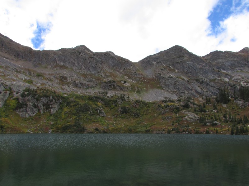
As the ridge got steeper, the terrain changed back to the grass-scree mixture. We reached a point where one can see both the lake below and a sheer wall on the north side of the ridge, and it was a beautiful sight. I especially enjoyed seeing what looked like a rock glacier crumpling into the lake.
Missouri Lakes.
Don't get too close
We continued up as the ridge got even steeper (but still very manageable), and shortly topped out at the summit. Because Savage Peak is relatively isolated, the views are outstanding, even at "only" 13,139 feet. We could see all the Elk 14ers, each covered in a light dusting of snow. Of course, viewing from the northeast meant that the Bells wore it the best. Mount Massive also had just a touch of new snow.
Topping out.
The drop off the summit, Missouri Lakes, and the Holy Cross area.
Better than work, eh? Yeah, better than work.
What a savage...
The Bells.
Capitol and Daly.
A full view to the south.
A full view to the west.
The weather was nice, but breezy and chilly, like any normal morning in the later half of September. To our north, low clouds were dancing among the summits of Holy Cross and Mount Jackson, making for a pretty sight.
The northern Sawatch and dancing low clouds.
To warm up, we decided to take our summit break just slightly back down the ridge, out of the wind and in the sun (whenever the clouds would move).
After a short while, we packed up and began the descent. We did it slightly differently than the ascent in two spots.
When it came time to get off the ridge and back to the valley, we left the ridge at a point slightly lower than where we got to it. The slope here wasn't quite as steep and had less scree. It is also possible to take the ridge almost the entire way down to have a very short, mellow descent into the valley. However, the walk back to the trail from that point would be through a more dense and rugged forest, unless you looped around back toward the lake. It could be quite a little bushwhack.
Speaking of the lake, we decided to give it a visit. We hugged the base of the slope leading to the northeast ridge all the way to the lake, over easy terrain. After resting at the lake for a bit, we immediately found the main trail and used it for the rest of our descent. I'd actually recommend ascending this way, since the point where we left the trail to cut across the glade was only a couple of minutes down from the lake, if that. Plus, going all the way to the lake before hugging the slope will save some grass from getting trampled.
The wall to the west of the lake.
Looking back up at Savage Peak from the lake.
The rest of the descent and drive back into town went smoothly, and we got to do some leaf-peeping on the way.
The wall to the west of the lake.
Looking back up at Savage Peak from the lake.
I'll be back in the area, for sure. I hear there are some "fancy" things around here. I highly recommend Savage Peak, a very fun outing in a beautiful area!
~Tony
Thumbnails for uploaded photos (click to open slideshow):
Comments or Questions
Caution: The information contained in this report may not be accurate and should not be the only resource used in preparation for your climb. Failure to have the necessary experience, physical conditioning, supplies or equipment can result in injury or death. 14ers.com and the author(s) of this report provide no warranties, either express or implied, that the information provided is accurate or reliable. By using the information provided, you agree to indemnify and hold harmless 14ers.com and the report author(s) with respect to any claims and demands against them, including any attorney fees and expenses. Please read the 14ers.com Safety and Disclaimer pages for more information.
Please respect private property: 14ers.com supports the rights of private landowners to determine how and by whom their land will be used. In Colorado, it is your responsibility to determine if land is private and to obtain the appropriate permission before entering the property.


 A morning view of the area.")
 This is the point where we began to cut across the glade toward the peak.")
 The mini-canyon.")
 Looking north toward the upper several lakes, which are scattered in the trees and along the slope bases.")
 Looking northwest from near the base of the slope leading to the ridge. You can see the first lake, just left and below of ce")
 Savage Peak from the base of the steep slope leading up a section of its northeast ridge.")
 Approaching the ridge crest.")
 Interesting rock patterns here.")
 The upper reaches of Savage Peak from a small bump on the ridge.")
 Missouri Lakes.")
 Don't get too close")
 Topping out.")
 The drop off the summit, Missouri Lakes, and the Holy Cross area.")
 Better than work, eh? Yeah, better than work.")
 What a savage...")
 The Bells.")
 Capitol and Daly.")
 A full view to the south.")
 A full view to the west.")
 The northern Sawatch and dancing low clouds.")
 The wall to the west of the lake.")
 Looking back up at Savage Peak from the lake.")
 The wall to the west of the lake.")
 Looking back up at Savage Peak from the lake.")
 Bonus: fish! We spotted them (heh) in a small pond below the lake.")
 Extra bonus: Changing colors of the forest undergrowth.")


