| Report Type | Full |
| Peak(s) |
Pyramid Peak - 14,029 feet |
| Date Posted | 11/22/2015 |
| Modified | 11/30/2015 |
| Date Climbed | 08/20/2015 |
| Author | DeTour |
| Additional Members | CharmingCatastrophe, Lucky |
| Pyramid success, with escort |
|---|
 We approached Pyramid in August with probably a greater sense of respect, determination, and frankly concern than any of our 30 previous 14ers. We had tried to climb Pyramid the year before, and for the first time after seven years of remarkable fortune, turned around without summiting. Despite ample experience, we found ourselves unprepared for the difficulties we encountered that day. After that, Mark talked more seriously than ever about retiring from 14ers, but the rest of our group convinced him to take another run at it this year. We decided to approach the peak from a campsite this year, primarily to help ensure a very early start, but also because we've come to love a limited amount of back country camping. That became a challenge in itself when the Forest Service closed Crater Lake to camping due to bear activity. Some intense research uncovered FS-recognized campsites beyond Crater Lake, either up Minnehaha Gulch or south of the lake. But both were a fair distance from the Pyramid trail, really no closer than the Maroon Lake parking lot. Mark remembered seeing some spots along the Pyramid trail last year that he thought could accommodate tents. We confirmed that this vicinity sat outside the FS no-camping zone, barely, and set off with that as our plan, not knowing exactly what we would find. And then there was the parking situation - or I should say, the &*$*@#$ parking situation. When can you drive up the road, would there be a parking spot, what was legal, what gets ticketed - all the BS that you go to the back country to escape. I know, Maroon Lake is NOT back country. But that magnificant, monstrous peak called. We left our motel in Basalt with a plan to get to the lake as early as the FS would let us, and figure out the parking from there. We timed it for a midafternoon arrival at the gate, knowing the official rules would state that we couldn't drive our vehicle up until 5, but hoping there would be some pragmatic flexibility on that point. 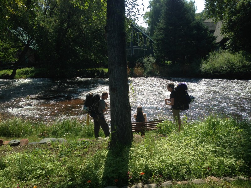 We arrived at the gate around 3:30 p.m. to see a discouraging sign posted: "Overnight lot full." But the ranger at the gate cheerfully announced, "I have good news for you. I just got back from up there and there are spots available." He beamed with pleasure at the cheer that burst forth spontaneously from our foursome in response. And he topped it off by waving us through. When we got to the overnight lot, we found seven vehicles parked in a lot that holds more than 30. Our conclusion: the FS is putting out some serious BS when it comes to parking at Maroon Lake. But hey, we were just glad to be past that logistical hurdle. After a ridiculously long preparation session in the lot allocating food and finishing the arranging of our packs, we set off into a blazing late afternoon sun. We packed enough food to camp up to three nights. If we succeeded on Pyramid, we hoped to take a rest day and then a run at North Maroon. Or, if we didn't summit Pyramid on our first attempt this year, maybe we'd try again.  Traffic on the trail was mostly tourists, but one descending climber took note of the microspikes dangling from our packs and asked where we were headed. When we said Pyramid he laughed and shook his head. "You won't need those. I was just up there last week." I didn't appreciate his unsolicited advice. We knew full well the snowfield in the basin could be bypassed, but not having ever used traction before, we wanted to take the opportunity to try them out. And, we were planning to follow a tip in an informative TR by Emcee Smith: use traction in the steep, often loose 1,000-foot gully leading up from the basin. 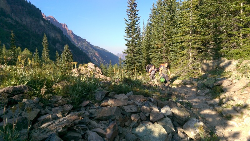  We turned off the Crater Lake trail onto the Pyramid trail and began scanning the terrain for potential campsites. About a quarter-mile in, the spots that Mark had remembered appeared in a stand of mixed pine and aspen directly adjacent to the trail. Sure enough, two nice tent sites, and the added bonus of a cozy fire pit. It was perfect for our group of four, not far from where the trail begins ascending up a steep slope leading to the amphitheater. An outcropping of rocks nearby provided a perfect spot to stash two bear canisters.   One thing the site lacked was water, so Mark and I headed off to Crater Lake. It's not far, I think about a half-mile, although it seemed much further the first time as Mark grumbled that we should have carried more water in so we wouldn't have to filter, which he had done, and he would have certainly told the rest of us to do if only we had possessed the sense to ask him. Personally, I kind of wanted to see this notable lake anyway - but when we arrived it was pretty disappointing. It might be called a lake in Colorado, but in Michigan we would call that a pond at best, or, if we were feeling a little snooty, a puddle. It was low and stagnant, surrounded by a shoreline of smelly mud, notably lacking in rocks to walk out on to get away from the mud. I ended up walking a log dozens of times in the days we were there to get water - learning in the process that our Sawyer bag filter system, which works great in a running stream, is not as well suited to a stagnant puddle. Excuse me, pond. Or lake, whatever.  Nevertheless, the challenges were minor, and the campsite was glorious, with stunning star-filled night skies, magnificent daytime views including the Maroon Bells framed in gorgeous aspen, and that addicting internal churn that comes from the knowledge that, tomorrow we climb.   We set our alarms for 4 a.m. and hit the trail at 4:48. It took us just about an hour to ascend the first steep slope and reach the mega-cairns that mark the beginning of the amphitheater. We paused to put on the spikes and walk up a snowfield that was quite a bit smaller than I had expected. I was glad to get the feel of walking on the packed snow in spikes. It was probably a bit faster than talus-hopping, and easier on the knees, although the snowfield had melted down to the point that neither made much difference in the big picture. I convinced myself the time gained on the snow at least washed with the time to put on the microspikes. We took another hour-plus to negotiate the amphitheater, and began ascending the steep 1,000-foot gully around 6:55. After clearing the initial talus at the base of the gully, we put the spikes back on for the steep scree that comprises most of the rest of that gully. I did indeed feel they were quite helpful on that stuff, in fact making the ascent safer. There are a few spots where the steepness of the slope presents a genuine hazard. Though it is clearly class two hiking, a slip on the scree is a real possibility, and the runout is serious. One spot where this is the case is about a third of the way up where one of the trail options skirts along some large fractured rocks on climber's left. There are other options further right which I would consider safer, especially if one is not equipped with traction aid. Our thanks go to Brian (SikYou) for loaning us his microspikes - he couldn't join us for this adventure, but his microspikes did!   Mark and I reached the 13,000 foot saddle around 8:10-8:15, a few minutes behind Maryjane and Dennis. A small cadre of goats appeared to greet us there. One in particular seemed especially fond of Maryjane, and would shadow us from there all the way to the summit. While others have told of problems with goats that stayed above them and presented rockfall hazards, our escort didn't seem to be a problem. He was indeed higher than us most of the time, but general lingered a bit behind our course, and I don't believe we encountered any rockfall from him. Looking at the photos afterward, it was amusing, if perhaps a bit creepy, to see how consistently that goat appeared in the background. Some were intentional goat-human "ussies," but many others were just photobombs.   We didn't stay long at the saddle. Last year, we had looked up from there at a peak that seemed impossibly forbidding, shrouded in rain clouds, with us lacking in energy and running late in the morning. This year everything was better. The weather was beautiful, we were earlier in the day, and our energy level and state of mind were much better. The peak still looked intimidating, but we were ready to take it one section at a time.  After a short traverse along the right side of the ridge past a second saddle, we soon faced a routefinding decision. Last year, we had gotten off-route not far from this point, ending up on a steep takus slope with no discernable way forward. At that point we had made the decision to turn around. I had concluded on the way back that we had crossed over to the left side of the ridge too early, below the crossover point clearly identified in Bill Middlebrook's route description (photo 17). I was obsessed with staying on the right side of the ridge until we knew we were at that "correct" crossover point. This year, as we negotiated the ridge, we found a clear cairned trail leading left, different from where we had crossed over last year, but definitely not the crossover point shown in the route description. I was concerned that we were repeating the previous year's mistake, but there was no path to the right here, and the trail and cairns to the left looked clear. As we picked our way along, I became more and more agitated that we had made the same mistake. But cairns and trail segments continued to provide a relatively stable course forward and up. After what seemed like a long time, but in fact was only about a half-hour, Mark, in the lead, called back to me to come join him on a small rise. There before us stretched a beautiful sight: the unmistakeable ledge traverse, clear confirmation that we were on-route. Relieved, we took a break there, around 9 a.m., accompanied by a goat. Then we enjoyed the two features on this mountain that get so much attention for so little real difficulty: the "leap of faith" and the ledge traverse.   The ledge traverse is every bit as easy as Middlebrook describes, with one section that is indeed narrow, but with ample holds for stability as you pass. The exposure here is a pretty much sheer drop that I guessed to be about 25 feet to a rubble field below - not dizzying, but plenty far enough to potentially kill you if you did fall.   That milestone was followed by a relatively short stretch of traversing Pyramid's rubble-strewn southeast slope to reach the iconic "green wall." There wasn't much elevation gain in this stretch, but we knew that would change when we reached that green rock.  We stood at the base of the "green wall" at 9:25 a.m. and commenced up it without a pause. I had always thought the many photos I've seen of this feature suggest that "wall" is a bit of an inflated term, and personal experience confirmed that. It's a steep, rocky feature, but it's a slope, not a wall. However, there was some serious exposure on much of it, especially the initial sections. The most exposed sections are pretty solidr by Elks standards. The rock has lots of fractures which help for holds, although the fractures generally run vertical, so taking advantage of them requires a bit of climbing technique. Overall, I would say this stretch offered some of the most exposed and challenging, and quite enjoyable, climbing I have been on. Mark took the lead on the scrambling, as he often does in our group. The rest followed pretty close behind, taking a variety of routes, as the rock offered many options. We had talked beforehand about precautions against rockfall, and our variety of routes provided some protection in that regard. Bringing up the rear, I made conscious decisions at times, where the rock seemed to present the option, to go a direction that kept me from being directly below others. But all in all, we experienced no rockfall issues on our ascent that I know of. Photos showed plenty of the infamous Pyramid "rubble-strewn ledges", but it just didn't seem to be a problem for us.  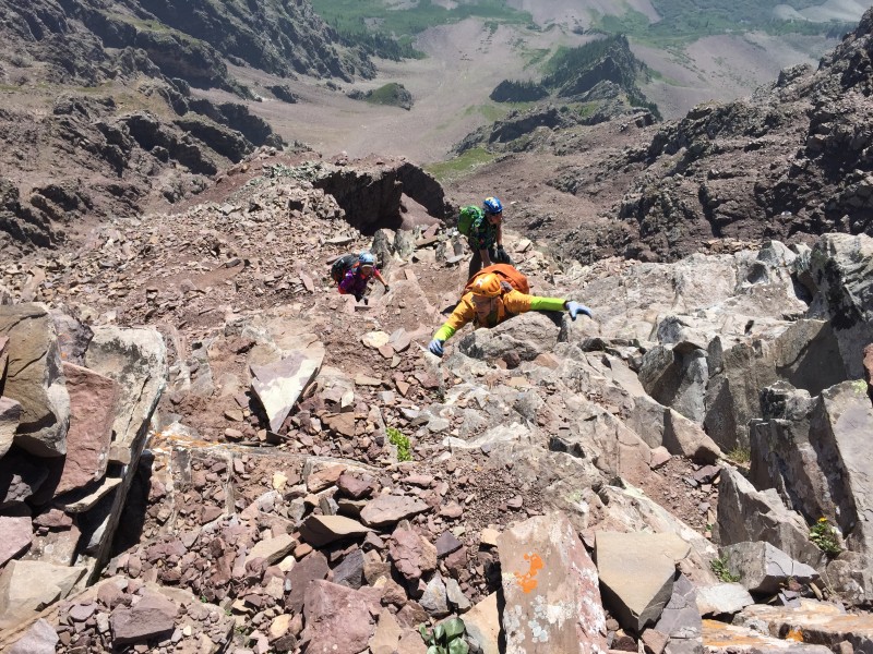 After maybe 10-15 minutes of climbing, a nice outcropping provided a good spot to regroup and pause. Someone noticed that a trail lay below us and to climbers' left, winding through rubble. Nobody expressed any regret about not using that trail. We were enjoying the climb and making decent time, and the trail at that point appeared to offer an abundance of unappealing loose scree. We began working left on our ascent from there, and soon found cairns that led us left off of the green rock. I had read of others finding multiple options to exit the green wall. I don't doubt the accuracy of that, but we spotted one trail of cairns, followed it, and it went fine for us. The terrain beyond the green wall was actually less challenging than I had expected. Someone compared this stretch to the summit pitch on Eolus, with switchbacking ledgy trails alternating with short steep climbs from one ledge to the next. I would agree with that assessment, although there is probably more hazard from loose rock on Pyramid. There was certainly more class two trail than I expected through here. We had been concerned about routefinding through this area. I had studied dozens of trip reports and checked other sources, but the terrain is such that details are hard to come by. This TR will be no exception to that rule. There simply aren't any outstanding features to describe. But Mark kept us spot on course all the way up, patiently spotting cairns and following what seemed to us to be a pretty clear, well-established route. Not that there weren't other options, but the way we went got us up the hill without drama. I will say Mark made a point of not blindly following ledges, especially those leading left, as we knew from research that some of those would abruptly end in hazardous cliffy terrain. He kept looking up - that is the objective, after all - and finding climber-friendly cairned paths to the next ledge.  We had only one scare with loose rock, but it was memorable. The trail led off to our right and then switchbacked left, about 20' above us. The terrain offered what looked like a good scrambling option to go straight up to that next ledge, bypassing the long switchback. Mark scrambled up, and Maryjane followed not far behind, with Dennis and me directly behind her. A solid-looking stack of several fractured dark grey blocks sat to Maryjane's right, above Dennis and me. Together they were about picnic-table size, sitting at a down slope that I would guess at maybe 20 degrees. (Knowing most people overestimate slope angle, I'm trying to be conservative there.) As she went by, Maryjane pushed off a little on that stack of blocks to her right - and gasped in horror when it slid downward several inches toward Dennis and me. She shouted at us to get out of there as fast as we could, which we did. She backed down herself without touching that booby-trapped block again and followed us on the trail. If you happen to be up there and see a stack of blocks that fits that description, I strongly advise avoiding that shortcut, or at least staying away from that stack. Eventually we reached a point where I found myself thinking, we might be getting close to the summit. I pushed the thought down, because I usually start thinking that way prematurely. But this time, moments later someone called down from above and, responding to Mark's question, told us he was on the summit. We looked around to realize we were at the spot captured in photo 34 of the route description. The options from there are either scrambling straight up a steep slope to the summit, or walking right and going up a summit ridge that arcs back to the left to the summit. Mark went straight up. Even though we had been opting for the scramble all morning, I chose the ridge walk. I wanted to savor the moment, and it was satisfying indeed. After turning back last year, every step along that ridge this day was buoyed by elation. The view opened up majestically to the Maroon Bells and other Elk monarchs to the west. The weather remained perfect. It was 10:20 a.m.  We shared the summit with a young solo climber and an older couple from Austria who had spent some time in the Alps. After the typical congratulations, admiring of views, and a little chatting, we each took our turn posing on the famous summit "diving board" rock.   I was the last of our group to visit the diving board - a visit which came to an abrupt end when the goat who had followed us up from the saddle decided to join us at the summit. He seemed to be coming straight for me on that diving board. I quickly concluded two things: there was not room for both of us on that rock, I was not interested in engaging the goat in a contest of wills for possession of that piece of ground. I vacated the rock, and sure enough, the goat marched right out on it and turned around as if preening for the cameras. And you can bet the cameras were out. The humans on Pyramid's summit turned into a bunch of paparazzi as the summit air was filled with the synthetic click-clack-click of cell phone cameras. 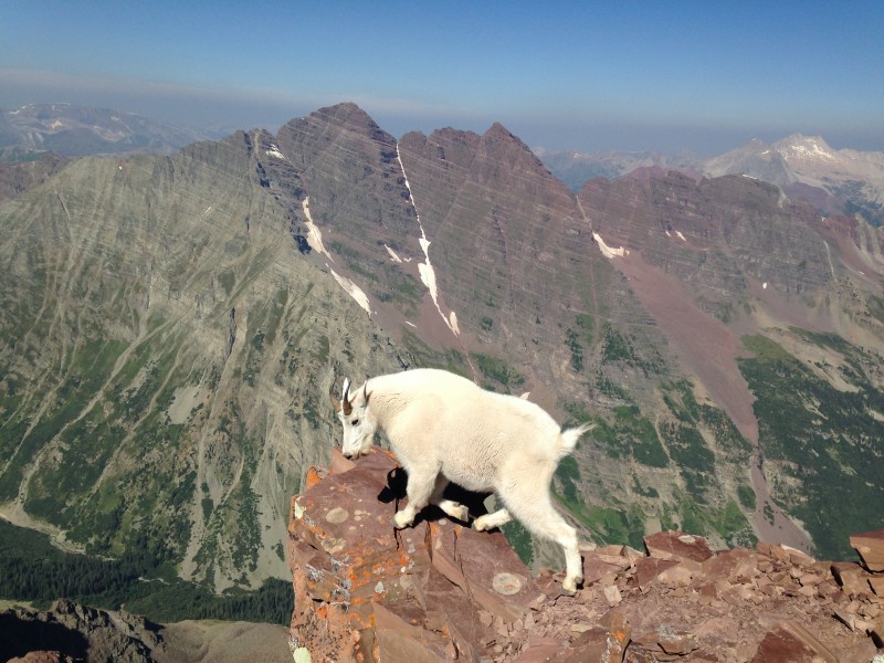 It didn't take long for the novelty to wear off and the cameras to go silent. The goat left his perch on the diving board and started just hanging out on the summit with the rest of us, no doubt watching to see if anyone would decide this was a good place and time to pee. (Nobody did.) Not long afterward, the goat made a return visit to the diving board, only to be ignored by the paparazzi this time. I thought he looked disappointed.  We headed down after about a half-hour on the summit. Routefinding was just as easy on the descent as on the way up. Some of the short steep downclimbs were challenging, the kind you have to take facing in and can't see what's below very well. Maryjane spotted me a couple times, and you could do a lot more of that than we did if necessary.  The only falling rock issue we had all day was one I kicked loose on the descent, a pure fatigue error of dragging a back foot instead of lifting. It was small, maybe plum-sized, and looked like it wouldn't go far. I said "sorry" with no tone of urgency to Maryjane a few feet below me as it skipped in front of her. Mark, maybe 40-50' below, watched casually for a moment as it looked like it would either stop or pass by quite some distance from him. Then he snapped to attention as he realized it was gaining velocity and then caromed off a rock at a crazy angle that sent it way too close to him for comfort. It whizzed by him and kept on going many hundreds of feet down the slope. Thankfully, there were no people down the direction it went, and it never sent any other rocks flying. But it was a stark reminder that even a seemingly trivial incident can turn dangerous in a heartbeat on these mountains.  It took us just over an hour to descend from the summit to the base of the green wall, and another 35 minutes to reach the saddle at 13,000 feet. On the way we finally passed the "Middlebrook crossover" that I had been so concerned with on the way up. It was not far above the point where we had crossed over the ridge on the ascent. 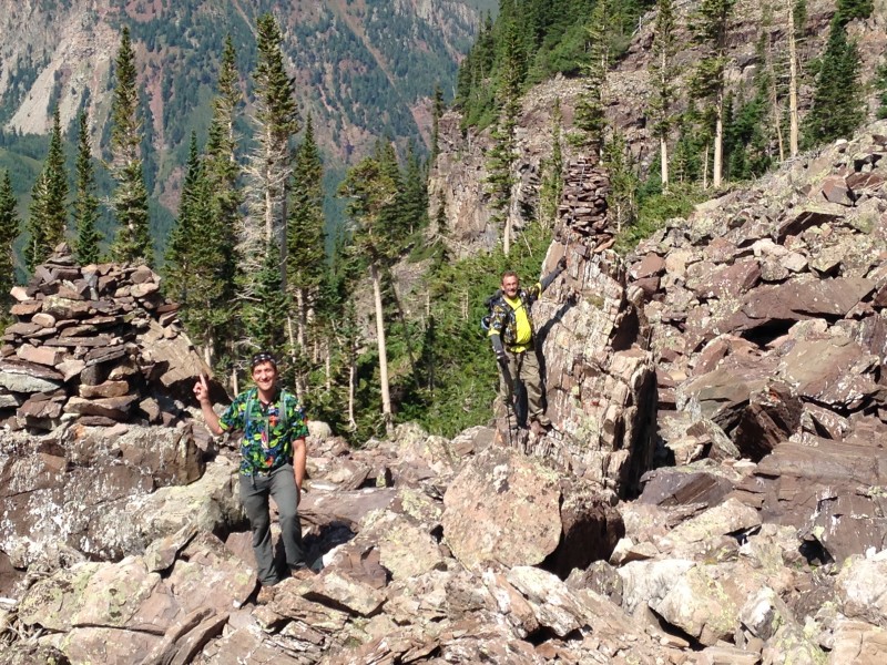 With bluebird weather holding, we took a long, satisfying break at the saddle. With no particular sense of urgency for the descent, it took us basically one hour to descend the gully, another to reach the huge cairns at the entrance to the amphitheater, and one more hour to descend the lower slope to our camp in the Maroon Creek basin. Along the way we found the snowfield in the amphitheater to be suitable for some slow-motion glissading.  Descending this mountain in good weather, with the glow of a successful summit, was a real treat. The views of the Bells and Maroon Lake were stunning, bathed in brilliant sunshine.   We had hiked in planning on camping up to three nights, to allow for this day's climb, a rest day, and another climb, of North Maroon. But we decided against trying North Maroon this year, in part due to challenging post-climb logistics as far as getting back to our jobs in Illinois, and in part to simply relax and enjoy the satisfaction of our great experience on Pyramid.  Thumbnails for uploaded photos (click to open slideshow):  Red carpet, Elks style.")
 First few steps on the trail always bring a rush of adrenaline, along with thoughts like,")
 Hiking in during daylight is a pleasure.")
 Great view from Crater Lake trail across the basin to our destination.")
 We arrived to find one campsite perfectly suited to our needs.")
 Great views of the Bells on the way in.")
 Best raspberries I've ever tasted")
 Watering hole.")
 View from gully - Bells, Snowmass, Capitol.")
")
 Scrambling with supervisor")
 Start of the really fun stuff - and the routefinding challenges")
 Looks kind of impressive here, right?")
 Yeah, maybe not all that hard")
")
 Ledge traverse.")
 Typical exposure on the upper 1,000 feet of this peak")
 Chillaxin' with the humans on the summit.")
 Steep terrain along the green rock. The rubble looks bad here, but we seemed to avoid most of it.")
 Dennis and me coming up the summit ridge.")
 Dear Daughter on the diving board.")
 Happy crew on the summit!")
")
 Playing in the snow on the descent")
 Here's some fairly intense downclimbing on the green rock - but MJ finds time for some posing.")
 Beautiful Maroon Lakes views from the lower Pyramid trail.")
 Next year's destination perhaps?")
")
")
")
 Goodbye to a hard-won summit.")
 Typical terrain between the ridge and the green wall.")
 Narrow but easy cross.")
 Part of the anticipation: pre-loading packs at our motel in Basalt.")
")
 How 'bout those cairns?")
 Two tents tucked tightly in the trees")
|
| Comments or Questions | ||||||||||||||||||||||||
|---|---|---|---|---|---|---|---|---|---|---|---|---|---|---|---|---|---|---|---|---|---|---|---|---|
|
Caution: The information contained in this report may not be accurate and should not be the only resource used in preparation for your climb. Failure to have the necessary experience, physical conditioning, supplies or equipment can result in injury or death. 14ers.com and the author(s) of this report provide no warranties, either express or implied, that the information provided is accurate or reliable. By using the information provided, you agree to indemnify and hold harmless 14ers.com and the report author(s) with respect to any claims and demands against them, including any attorney fees and expenses. Please read the 14ers.com Safety and Disclaimer pages for more information.
Please respect private property: 14ers.com supports the rights of private landowners to determine how and by whom their land will be used. In Colorado, it is your responsibility to determine if land is private and to obtain the appropriate permission before entering the property.


