| Report Type | Full |
| Peak(s) |
Crestone Needle - 14,196 feet Crestone Peak - 14,299 feet |
| Date Posted | 01/10/2016 |
| Date Climbed | 08/15/2015 |
| Author | Lville |
| The Needle and the Peakage DONE! |
|---|
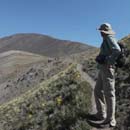
  New Year's Resolutions: Thrive on a steady diet of 14ers. Resolve to complete unfinished trip reports before a year or more has elapsed. Trim them down just a bit. Exercise greater restraint in inclusion of detail ... unless it's a landmark peak for me, in which case I may continue to overindulge ... IntroductionMagnifique!, I would have thought to myself if I thought to myself in French. Sadly, "Magnificent" seems more likely, if less worthy. It was a year earlier in 2014 on my descent from Humboldt Peak - my 15th 14er - and I had just found an accommodating rock on which to perch where I stopped to admire the grand panorama before me. To the southwest were the Crestones; the Needle and the Peak were standing guard over South Colony Lakes 2000 feet below. Usually, I find myself rushing down from most high mountains in an attempt to outrun inclement weather. But on this day, with dark clouds only just beginning to gather behind me, I lingered to appreciate the "bat wings" across the way and envision myself on the respective pinnacles of this dynamic duo. I knew I would be back. (Note: I guess the name "Crestones" also includes at least Kit Carson and Humboldt, but I use it here to refer solely to the 14ers that bear the name - Crestone Needle and Crestone Peak). Fast forward to 2015. Now at 28 peaks, I was just shy of the halfway mark on the list, with the lion's share of them coming in the last three summers. My Class 3 14er resume, modest but not insubstantial, was represented by Longs Peak (twice), Wetterhorn, and Kelso Ridge. But this summer, I had mostly been knocking out some of the remaining Sawatch peaks and running out of the "walk-ups". It was time to expand my playlist and claim my backstage pass to see the 'stones. I had recently been buying up gear in the expectation that I would *have* to pack in to check off the Crestones, along with Chicago Basin, Kit Carson and the like, and I was excited about the prospect of a backpacking weekend and summiting two spectacular peaks. To be sure, I was a tad apprehensive, though the steep Peak and Needle did not intimidate me as much as some of their Class 3 brethren that remained, I think because of the solid rock. I had one problem however - I had never before done any backpacking and I'm no Spring Chicken. Just walking around REI w/ 35 lbs of bean bags stuffed inside a backpack messed with my equilibrium. I wondered if my first overnighter should be something less enterprising like Harvard/Columbia or Holy Cross. This would be an ambitious undertaking for me. But I had expected to get the Crestones in 2014, and now 2015 was winding down. I would be extremely disappointed if I didn't capture these two and prove something to myself this year. If I couldn't do this in 2015, then I probably had no business thinking about Chicago Basin or any other "top tens" next year. I'm not ready to boldly state that I'll attempt all 58, but I spend plenty of time thinking about it. StatsTrailhead (Friday 8/14/15): South Colony (9930') Left 4wd parking at 4:27p Old 4wd parking lot at 6:09p Camping spot 7'ish (2 hr 30 min) (11,600') (gain 1700') start Peak (Saturday): 5:25a Bh pass: 6:32a Cottonwood lake: 7:10a summit: 9:40a (4 hr 15 min) start down 10:10a Cottonwood lake 12:35p Bh pass: 1:05p camp: 2:35p (4 hr 25 min) total RT: 9hrs 10 mins gain: approx 4000' start Needle (Sunday): 5:38a Bh pass: 6:58a Dihedral: 8:25a summit: 9:24a (3 hr 46 min) start down: 9:40a Dihedral: 10:24a Bh pass: 11:30a camp: 12:53p (3 hrs 13 min) total RT: 7 hr 15 min gain: approx. 2800' Leave camp (Sunday): 1:39p Old 4wd: 2:26p 4wd parking lot trailhead: 3:42p (2 hr 15 min) PreparationPhysically, I felt that I was in decent shape having maintained a fairly regular exercise regimen since 2013 which was motivated in large part by my first ascent of Longs Peak in August of that year. And in addition to a flurry of 14ers in '14 and some forays into the Flatirons, I had grabbed six more 'teeners since late June, including the two-fer of Castle & Conundrum the previous weekend. To improve my chances of meeting my mid-life peak-bagging goals, I had decided to pay a few extra clams for some relatively lightweight gear - with some strategic use of my REI 20% off coupons. According to my bathroom scale, my base weight was under 30 lbs. Adding consumables of about 5 lbs, my pack weight was maybe a max of 33-35 lbs. I was feeling pretty good about that number as it compared favorably with my companions' cargo. I hoped I wasn't missing some important items. Some of my gear (easy enough to bypass this section, but I'm always curious so I suspect a few others are as well - weights are approximate): -Big Agnes Copper Spur UL 2 (UL 1 was simply too small) w/ floor mat. 3 lbs? -Thermarest NeoAir Xlite large. 16 oz. The crinkliness is not an issue. -Mont-bell Down Hugger 800 Long. 2.5 lbs? Not ultra-lite by any means, but good mix of comfort/weight. -Osprey 60L Aether w/ raincover. 5 lbs (see below) -Peak Bag REI Flash 18. 1 lb -REI blue pillow. 9 oz. -Sawyer water filter. 8 oz? new experience for me. Will use again! -Jetboil. 1 lb. Too much fun. -First aid kit/basic toiletries, sunscreen -Helmet - don't think twice about this. Wear one on Class 3. -trekking poles. They go where I go. -A few lightweight sacks for organization and bear bag. -Iphone charger for pix, texts, weather updates, sports scores. I had reception most of the time. -Some more misc stuff that I won't try to list. Clothes: -long hiking pants -two polyester T-shirts -one polyester baselayer tops/bottoms (only used for sleeping warmth) -down vest -extra socks (sleep in the "clean" ones, hike in the other, and ya got 'em if ya need 'em) -windbreaker -did *not* bring nor did I need microspikes or ice axe in mid-Aug Food: -Two Mountain House freeze-dried meals, 3 PBJ's, two hard-boiled eggs, and an assortment of protein/granola bars. Enough water to get me to the campsite where I could filter more. Wished I had brought: -Gatorade mix (if not full-on Gatorade - ultralight be damned) -more breakfast: e.g. maybe bagels, banana, oatmeal packets, freeze-dried scrambled eggs (sounds gross but who knows?) The Aether 60 is maybe too heavy at 5 lbs, but I liked the support it offered. Choosing a backpack was a laborious process and I knew no matter how many packs I tried on, I would never determine which pack was ideal w/o actually using them in the field. The Aether worked out OK. Almost just as important to me was my choice of a "peak bag". I wished to avoid the additional weight of my regular 3 lb daypack and I wanted to be able to carry it in my overnight pack. The Flash 18 I think fits the bill. Pretty minimalist w/ no structure (so I could fold it), but it holds a camelback, very basic first aid/food/clothes, and my poles. Now, if I had my own Sangre de Cristo Sherpa, I would have included at least two oversized comfortable pillows as well, but of course this was not a viable option and would not be very sporting. So I grabbed the mid-size blue suede pillow thing from REI that I imagine to be stuffed w/ some lightweight foam. I figured out later that cramming my down vest and a couple of extra clothing items into a stuff sack might accomplish the same thing, and no doubt I would have survived w/ one or the other, but the two items taken together provided some extra neck support and made for a quite comfortable nights rest without a significant weight penalty. Part of the complexity of my trip planning was in finding partners which was a priority since I knew that these mountains were less traveled and would provide stiffer resistance than a number of the others. It's often a challenge to plan even a one day 14er trip - much less a three day weekend - very far in advance given all the variables involved like weather, last minute schedule changes, and general readiness. I did not wish to commit to anyone else or vice versa much in advance, and then have to back out at the last minute. But in this case, things came together nicely. I had been watching forum posts, uncertain of what the weekend might hold, when a friend of a friend, mspalding (Mike) showed up on the forum on a wed nite looking for partners to get numbers 56 & 57. I contacted Mike and we made plans for the weekend. He was picking up an additional two hikers from Golden so there would be four total in our party which was ideal. Fri 8/14/15 - The Drive to Westcliffe and the Backpack InI finished final packing and was on the road from Louisville by 11:15am. Traffic was good midday and I was looking forward to retracing my steps to Westcliffe from 2014's Humboldt visit. Mike and I synced up perfectly as we arrived at the 2wd trailhead within minutes of each other around 3pm and began the transfer of packs and people from his vehicle to mine, and off we went up the road to the 4wd lot. The road had not been a big problem the previous year but I was a little concerned from recent reports that suggested that it had since grown worse. We were pleasantly surprised however to see evidence of recent (perhaps that day) road grading activity. Still a few rough spots, but nothing that a 4wd w/ decent clearance couldn't handle - and pretty much zero exposure on this road.  Upon arrival at the 4wd lot and probably much to the dismay of my good-natured passengers, I announced that I was trying something new to ward off critters and attendant chewed brake lines, fuel lines, odometers etc. I had recently purchased wire fencing to separate my truck from the wild and, today, I intended to deploy it for the first time. A few thoughts here. I debated between chicken wire and a stronger fencing that was a step up from the chicken wire and I opted for the stronger stuff. Pros: stronger/stiffer, smaller holes Cons: heavier/larger, more expensive, less pliable, sharper edges. Generally more cumbersome and time consuming to put up and take down. Had to use two rolls which meant wiring the rolls together. In the future, I'll have the connecting wires already in place and have an extra pair or two of gloves handy for any helpers. There has been much debate on the 14er forums about what works best and I suppose the jury is still out. Perhaps moth balls, coyote urine, strobe lights, or hope-n-pray would be simpler, but as long as I have a flat surface on which to park, I think any vermin with designs on my salty engine will move on to the next vehicle. In retrospect, I might just go w/ the chicken wire, and I probably wouldn't bother on a day hike. But for an overnighter (or two nights in this case), I'm glad I did it as the peace of mind was substantial and the potential penalty significant. I had to attempt sleep in my truck at the Wetterhorn trailhead last year while listening to some kind of creature bump around in my engine all night. Not fun. My fortress in place, our party started up the trail at 4:30pm. Possibly a little later than ideal but at least it allowed us to avoid the wicked storm that was hitting our campground during the drive in. I knew I was up to the task and I may have had the lightest pack in my group, but it still seemed obscenely heavy as I hoisted it up on my shoulders and set out for South Colony Lakes.  I liked that I was a member of this foursome as we were all of similar age and I, even at 28 peaks checked off, was I think the least experienced of the group. In the blue hat, Neil, whom I called Eric for some reason for the first 24 hours and then on and off again after that, carried a heavy camera around his neck snapping pictures every so often but still covered ground faster than I. Wearing a white safari hat was Mike. I felt particularly fortunate to be hiking with Mike, as he looked out for everyone - especially me - over the next two days. And I know what you're thinking about Andrew. That he dabbles in wizardry or lords over the Middle Earth or some such. But I'm not sure that's fair. He was a very peaceable fellow and any magic that he may have been practicing was of the good sort as we made it up the trail in decent time w/ no problems. Good hiking companions these three. At 6:10p, we paused for debate at the "old" 4wd trailhead to decide whether to take the longer, supposedly more straightforward route that contoured to the left and crossed the stream immediately over a nice footbridge, or the shorter but possibly more complex route to the right towards Humboldt, postponing the stream crossing until later. We ended up on the circuitous route to the left for which I had lobbied but I might now opt for the shorter path. At this late hour with more hiking and selection of campsites still to come, I wanted the "sure thing". I had read about bushwhacking and lost trails on the "shortcut", but my recollection was that the Humboldt trail which took me pretty close to the right side of the creek probably *was* the shortcut, and one needed only to then cross over the creek to get to the Needle side. My only concern was in finding a viable place to cross over. Turns out (from taking the shortcut on the way out on Sunday) that there are at least a couple of places to cross and the bushwhacking and route-finding seemed minimal, though parts of the trail were quite wet and muddy near the creek. Our choice to go left wasn't way out of line however as we reached the campsite areas around 7:10p and probably didn't add more than 15-20 mins to the total hike time. Campsites were not plentiful on a Friday night at 7pm and we lost additional time wandering around in fading light in an attempt to find a decent spot that would hold all four tents. Just about the time that we were ready to split up the team, Neil found a nice area that accommodated the entire group, sort of. We set up tents, filtered some water, hung bear bags in the dark (OK - Mike hung mine), and went to bed with the plan to hit the trail for the Peak at 5:15a. 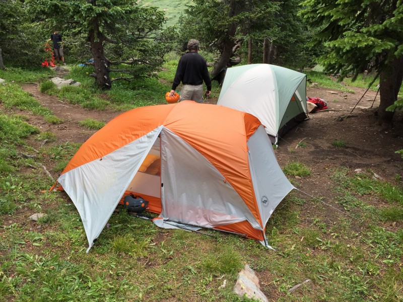 Sat 8/15/15 - Crestone PeakMy wake up time of 4:40a came too quickly. My air mattress won't be mistaken for the accommodations at a five-star hotel as I found myself rotating 90 degrees throughout the night - rotisserie style - to remain comfortable, but I slept surprisingly well at 11,600 ft in temps that probably never dipped below 40 degrees. Getting organized in the dark and cold in a small space was challenging and time-consuming, but I managed. Then I wolfed down the first of my two hard-boiled eggs along w/ my three Advil and we hit the trail at 5:25a. 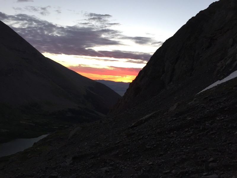 The hike up to Broken Hand pass was everything I hoped it wouldn't be. One hour plus of sometimes tough and slippery incline, but no snowfield worries in mid-August. The headlamps bobbing in the distance reminded me of Longs Peak. There was some moderate scrambling required, but nothing too demanding or dangerous. Near the top, I absolutely was happy to have my helmet on as we passed beneath some tall rock structures that could potentially rain some wayward debris down on us, but it seemed unlikely. Our timing was about right as our arrival at the steeper, rockier portions near the top of the pass coincided with the sun's appearance behind us. To me, the sunrise is always a welcome gift providing relief from the dark mysteries of the night, and it was exceptional this morning as we kept turning to snap pictures. As would be the case the next day when we repeated this routine, the ascent to the pass was an early test on the lungs and legs, but was over relatively quickly.   While it's not a stretch to construe the finger picture as a "Broken Hand", I believe that the Broken Hand is actually a mitten-like structure up along the ridge to Broken Hand Peak to climber's left. I think I have a pic of it in my Humboldt trip report.  At the top of the pass at 12,800, we were rewarded with an impressive view of the Needle up to our right and Cottonwood Lake in front of us down below at 12,000 which would be our next destination. The sometimes steep walk down to this lake would be a welcome change from what we had just endured, but it was a mixed bag as every step down represented an elevation loss that would have to be reclaimed - twice. It was already decided that we would attempt the Peak first followed by the Needle on day two, but I couldn't help but wonder if we should just grab the Needle first as it was so much closer - only 1400 feet up from where we stood as opposed to dropping 800 feet followed by a 2300 foot climb, not to mention having to re-ascend BHP from the Cottonwood side after a long, hard day of climbing. Best to get the longer hike out of the way on day one we figured.  I was looking forward to getting my first live view of the infamous "Red Gully" that granted passage to the summit of the Peak. We were also treated to some wonderful wildflowers around Cottonwood Lake and I could understand the allure of an approach and camp from this side of the pass. 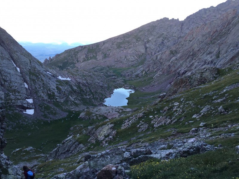 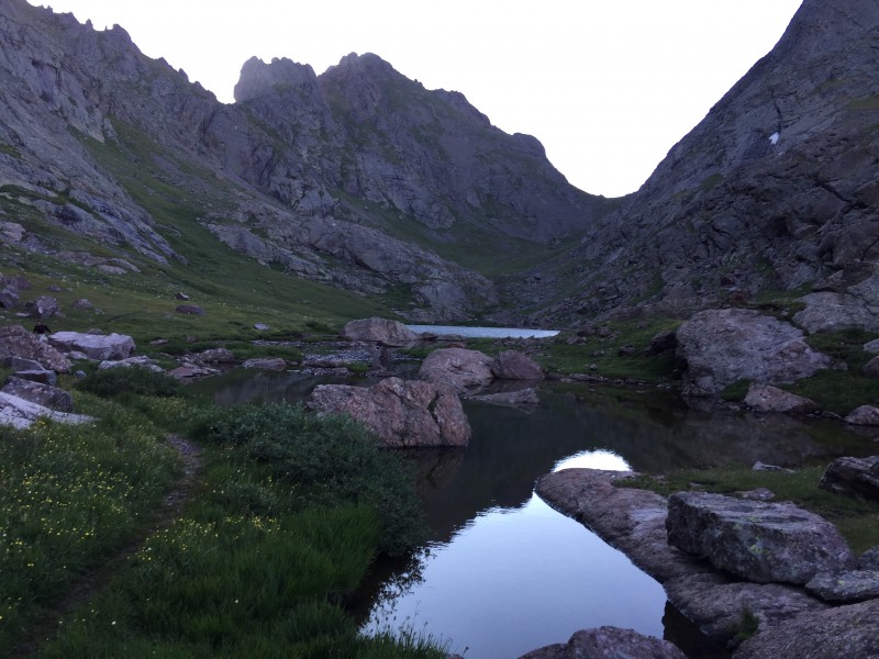  The trek from the lake to the Red Gully was farther than I expected. You must go up and to the right to circumvent the steep wall at the base of the gully before cutting sharply back left to gain entry. A well-defined trail leads the way but on the way back down, we momentarily forgot this detail and got a little off route. This is something you need to think about upon your return. The Red Gully itself reminded me somewhat of the Trough on Longs. Similar in steepness, it was more solid, but was also a bit wet in places where more care was required as there is significant drainage here. Clearly some Class 3, but quite doable I felt. I marveled at the mosaic of wonderfully juggy, multi-colored conglomerate rock and tried to avoid too many stops for rest and pictures. The one aspect of the climb that made me the most nervous was the prospect of foul weather. I calculated that we would be hitting BHP near 13K feet on the way back at around 1 PM which I was dreading, but the sky was perfectly blue and almost cloudless for now. I figured that worst-case, we could hunker down near Cottonwood Lake if storms threatened and then go over the pass after any storms had moved on.    A Billion Years Collapsed into Two Minutes Part of the package for me in appreciating the mountains is to understand a little bit about their origins and evolution - the sequence of events that occurred prior to my chance meeting with them at this point in time. In addition to providing visual appeal and great hand holds, the Crestone conglomerates are also compelling because they can speak to us in terms of ongoing processes that we can observe today, yet they seem so out of place at 14,000 feet. The literature on the geology of the Rockies and its individual ranges is plentiful, but I'll attempt a short summary here. The individual clasts of this assemblage, some of them predating a billion years, tumbled down from the Ancestral Rockies about 300 million years ago as present day Colorado lay near the equator, and before mammals or dinosaurs were around to witness the event. You can perhaps imagine rocks crashing down from cliffs above composed of various rock types, shattering into smaller chunks and continuing steeply downstream aided by water and gravity on a journey that terminated in their current jumbled configuration. The constituent particles are of greatly varying sizes - an indication that they were deposited in a high energy environment near their source, not unlike what you might see today in a swiftly moving mountain stream. The sedimentary rocks of the Maroon Bells and the Flatirons were similarly also a product of erosion of the same ancient range, albeit farther from their source as their smaller and better sorted particle sizes would attest. The Ancestral Rockies have long since disappeared, a victim of steady decay, but massive volumes of the detritus were dumped near where the Sangre de Cristos currently reside. Beginning about 70 million years ago and continuing today, tectonic forces lifted the "modern" Rockies to their current dizzying heights above the surrounding valleys. Glaciation, occurring in cycles and as recent as twelve thousand years ago, then carved up the Crestones to give them their current rugged character. Glacial striations, generally parallel lines scratched into the rock as glaciers scrape their way forward, can be seen in places along the hike from the parking lot to the lakes. Viewing the recent widespread catastrophic destruction near Mt Lindsey and Grand Mesa, and the damage inflicted by the 2013 flooding in and around Boulder, it's not hard to envision how freeze/thaw cycles, great torrents of water, and an earthquake here and there can bring down a mountain range over time, perhaps recycling the rocks to begin the process anew. In any case, I hoped that a rock wouldn't land on my noggin and deprive me of the remainder of my miniscule slice of the pie.  If memory serves, one could see the top of the gully from quite a ways down, but then I was dismayed to find that we had to hang a left at the saddle and scramble a bit more to gain the actual summit. Not too bad really and kind of fun, it's just that I was tired and ready to be at the top!  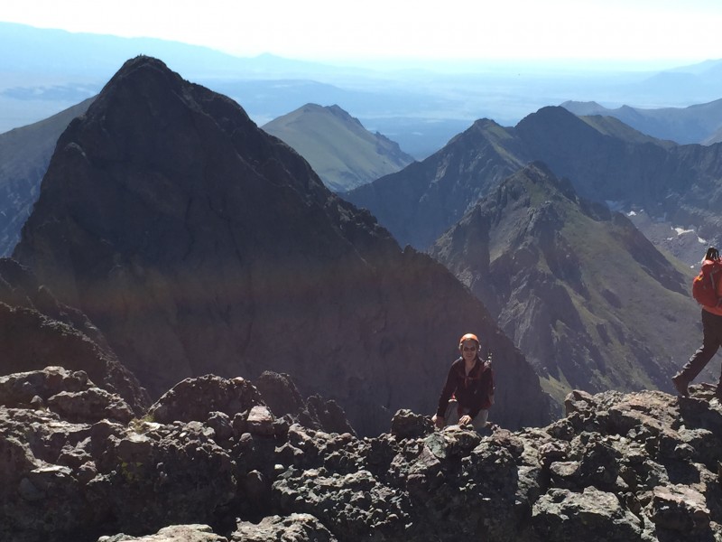 We hung out a bit, snapping pics and having lunch, but I was anxious to get down as wonder gave way to worry about the weather two or three hours hence. 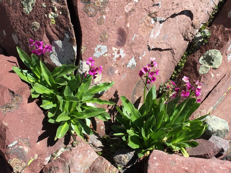  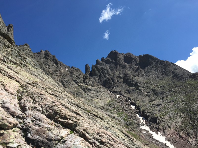 We made it back to Cottonwood Lake w/o incident other than the misstep at the gully base that cost us approx 15-20 minutes, but the long slog back up to BHP was inglorious. I started promising myself rests at 100 steps but then would go an extra 25 as a bonus before stopping. Eventually we hit the pass and *finally* were able to start moving toward safety as the sky darkened and we heard a few rumblings. I had held my own throughout the hike, but rock-hopping downhill is where I struggle the most and BHP was no exception. I think that due to knees that have seen better days, I simply can't keep up. I told everyone to go on ahead, except that Mike insisted on accompanying me to the finish line, repeating the mantra of "safety first" which I appreciated. It's a long haul down this side of the pass and a twisted or broken ankle is not out of the question. I think someone w/ an ankle or leg injury was actually airlifted from Cottonwood Lake earlier in the day after having to spend the night outside. I was looking forward to a restful afternoon of perhaps a nice nap followed by plenty of daylight in which to filter water, cook dinner, get better organized, and then spend some time rehashing our exploits, but it was not to be. No sooner had I settled in for the nap part, than a terrific thunderstorm hit which lasted the rest of the afternoon. I stretched out on my pad w/ my bag thrown lightly over me, enjoying a divine combination of restfulness and accomplishment as a light rain began to fall. It soon gained in intensity and I started wishing that I had chosen a site w/ some tree shelter. Suddenly the precip turned into more of a popping sound and I realized that hail was probably pelting the rain fly on my lightweight tent. This was confirmed when I peeked out into the vestibule and saw hail between the size of a pea and a grape bouncing up under the fly which continued for 30 mins or more. Meanwhile, the sky was being ripped open by numerous lightning bolts and attendant roars of thunder that raced across the sky, bouncing off the surrounding mountainsides for several seconds before dissipating. From flash-bang counting, I guessed that the lightning was within a half-mile, which put it on the ridges directly above me. I crawled farther into my bag. I hoped that my rain fly was strong enough to withstand the pounding of the hail stones as I knew that everything in my tent would get completely soaked in a matter of seconds and it would be game over for my weekend if the fly did not hold. Reasoning that Big Agnes thinks about such things when they design this stuff, I lay there just savoring the clarity of the sound outside while huddled within the relative safety of my little tent.  Several hours elapsed before the rain subsided, allowing folks to re-emerge from their various shelters to survey our surroundings. The thick layer of hail on the landscape belied the tranquility of the clear skies that now prevailed as the sun reappeared, illuminating brilliantly the top of one of the mountainsides (missed this pic, darn!). Now behind schedule with the sun due to set shortly, I picked my way carefully through the mud down to the creek to filter water for my jetboiled dinner. All things considered, this not-unusual, late-afternoon alpine weather episode was one of the best parts of my weekend, and I reflected on the fact that we were fortunate to have it happen on Saturday rather than during the hike in or hike out on Fri/Sun. Around 10pm, I drifted off to sleep, dreading another cold, dark, early morning wakeup call - a little tense about what lay ahead, but thrilled to be going after the Needle. Sun 8/16/15 - Crestone NeedleThe Needle is reportedly the last of the Colorado 14ers to be "officially" summited, in 1916 (though I'm sure the coolest Native Americans would have gone up there well prior to that date). Today, almost 100 years later, Mike and I would be taking our shot at it. We decided on a slightly later 5:30am start time in order to give the mountain a few extra minutes to dry out before hosting our next event. Back up BHP I went, this time not properly fortified w/ a decent breakfast. Soon enough however, we were at the pass and looking up at the "East Gully" of the Needle with a crisp bluebird backdrop. But like the Peak, there was a little meandering that had to be done before entering the East Gully.  I had read enough accounts of others' adventures climbing the Needle that I had a pretty clear mental picture of the upper parts of the route within the East/West gullies, but I was inadequately prepared for the portion between BHP and the start of the East Gully. The path is actually well established as it winds around a bit, but when we reached a little rise in the rocks and looked down for the trail, all I saw was a down climb that looked riskier than anything I was expecting and I thought we had gotten off-route. I yelled back to Mike that there must be a turn off that we'd missed since I felt certain that this particular part of the climb would have been a point of emphasis in others' trip reports and it would have stood out to me. Mike and I then switched places as I backtracked and he took a look at what I was seeing. I saw no good alternatives and went back up to join Mike. We were a bit perplexed as we gazed down below at a crag that would require some goat-stepping around to the right and then what appeared to be a "jump" over onto the prominence below, which itself looked quite steep from my viewpoint. Good thing I was hiking w/ Mike as I might have just turned back, convinced that if this was the correct way, I would have known about it. Mike decided to be the guinea pig as he carefully picked his way down to the right and successfully navigated across the little "jump" onto the other rock. No problem. I followed, cautiously facing in as I let Mike direct my foot placement across the gap. Then to my amazement I found that the destination outcrop was not steep at all - a simple class 2 walk-down that put us back on the defined path to the East Gully. I silently cursed all previous Needle-Trip-Report-Writers for not having brought this little move to my attention and I fretted over having to repeat it in reverse on the way back - until I returned four hours later and realized there was not much to it and I was the only one who had seemed fazed by it. And of course I revisited some trip reports only to find that it had been mentioned in a number of cases and I just missed it. In retrospect, it wasn't a big deal, it just weirded me out initially for some reason. I guess because I wasn't expecting it. Similar to, say, the Trough Chockstone. Just be aware of it. On to the East Gully. 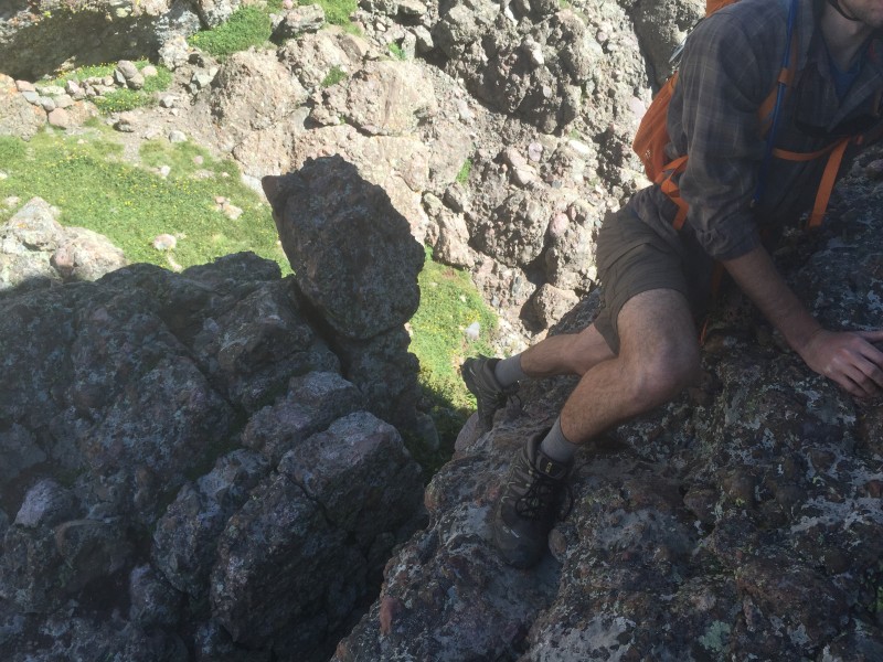 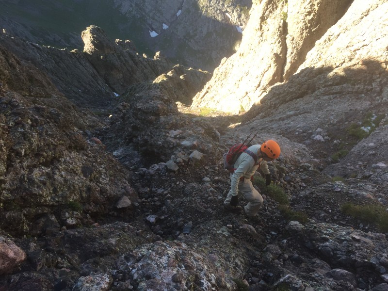 Several other 14er meet-up folks and a CMC group had arrived over the weekend and "Mikel" (pronounced "Michael" - not sure I captured the spelling correctly but close I think) who had joined us on the down climb of the Peak, caught up w/ us in the East Gully and the three of us climbed together for the rest of the day. I was pleased to be hiking w/ the two of them as they were both obviously more comfortable w/ the conditions than I was. Like Mike, Mikel was experienced, helpful, and another great hiking partner - though given to bouts of running off to explore alternate trails. The East Gully was pretty much what I was expecting and I looked forward to my first meeting w/ the crossover to the West Gully which I had memorized. Granted, there were times when I wanted silence from Mike and Mikel who were carrying on amiably the whole way up as I muttered things like "this is *not* Class 3, this *has* to be Class 4". Well, it's not. Mostly. No doubt you can *choose* some Class 4 if you wish and there were a few moves that I might always do "face-in" upon descent, perhaps qualifying for Class 4, but it truly is Class 3 - until "The Dihedral". The Dihedral and the Crossover to the West GullyWe were finally at the part that I was most anticipating. This was like "The Slab" and "Staircase" on Wetterhorn, the "mini knife-edge" on Kelso Ridge, or the "Keyhole" (and everything after) on Longs. And finally *I* got to be the expert as Mike/Mikel speculated all the way up on whether we were at the crossover or not. I knew exactly what I was looking for. I think at this juncture our band expanded from a power trio to a quintet as we were joined by the "Nashville Cats" - two friendly young fellas whose names I've forgotten but at least one of them was from Nashville.   My confidence growing as it felt like the end was in sight and the sky was looking great, I made quick work of the Dihedral and was happy to lead our group up and over into the West Gully. I didn't stop for many pictures on my way up as I wanted to keep moving in the interests of time and I was eager to scramble up a ways to get my first peek into the West Gully, but I'll include some shots here taken on the descent w/ one of the gents demonstrating the foot placement back across the Dihedral. This was the one move where I didn't find a juggy hold but it wasn't too bad on dry rock. The potential fall was maybe only six to eight feet with a degree of difficulty not much higher than navigating through Costco on a Saturday afternoon, but it was just hairy enough that if this section had been on a cliff w/ a significant drop, I might have turned around and gone home.    The ascent up to the rib or "shark fin" between the gullies can look intimidating, especially in some of the pictures I've seen, but it really wasn't difficult as long as care is taken. It's not even close to vertical, and it has no shortage of great holds for both hands and feet. I suppose that if the drop was 1000 feet, it might have caused me some fright, but even though falling here may have had the same consequences, it's mentally much easier for me when the rock is at an angle and maybe 20 or 30 feet. Just lean into the rock, be careful, and go. More risky if slippery.  After the initial ascent to the shark fin, another short, less steep climb follows before dropping into the West Gully. I was now beginning to relax as I got to sit atop the second rib while I waited for the others to appear. I made a point to look all around me so that I would recognize this crossover on the way back down - even though I was reasonably sure that the green hanky that had been left there as a marker by someone else would still be present upon our return.  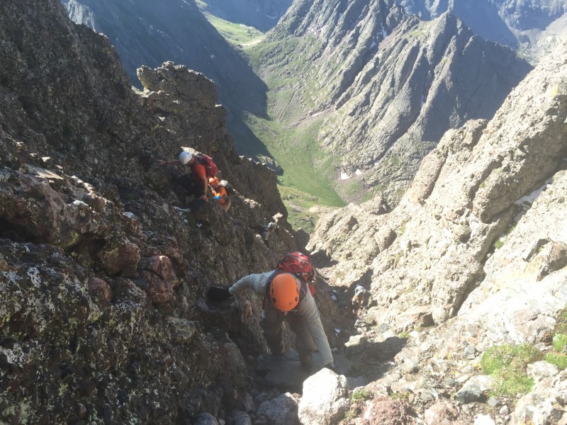 From this point at approx 13,600, it was just more of the same for the remainder of the climb. At the top, I felt exultant but, per usual, I was unable to allow myself too much time for relaxation and exploration as I knew that it would take a while to get back down to BHP and even then we still wouldn't be home free. But it was nice to have a bite to eat, take some pix, and celebrate w/ the others.   My preferred method of descent for much of the return trip was to drop down on my butt and crabwalk using lots of arms. A nice little triceps workout. Some of this may have even gone quicker than going up since you could see where you were going very clearly and gravity was now an ally. As a cautionary tale, I was scooting down face-out on all fours and I think my butt dislodged a baseball-sized rock. At first I thought it might slow to a stop, but it did not and continued to gain speed as it headed in the general direction of one of the Nashville Cats. I started yelling "ROCK" as a safety precaution even though it wasn't headed straight at him. Suddenly it bounced and was redirected as if it had eyes and bad intentions. I don't even know if it made a big impression on him, but it certainly would have, had it not missed his head by just a few feet. It was kind of unsettling as I watched the situation unfold. It goes without saying to proceed w/ extreme care, yell "ROCK" as loud as you can for as long as you need to, and if you're down below, react quickly and hunker down. After crossing back into the East Gully and descending a ways, there was some confusion as we couldn't remember how far down to go before hanging a left back onto the trail. There was a well-defined path to the left at one point that Mikel decided to check out but he soon returned and we resumed our descent. I didn't get good photos here, so just pay close attention on your way up. There is probably more than one way to do this. When we returned to the "gap" described earlier within a stone's throw or two of BHP, I was relieved to find that the stepover and upclimb was mostly straightforward and the last primary obstacle was to beat the weather back to camp. 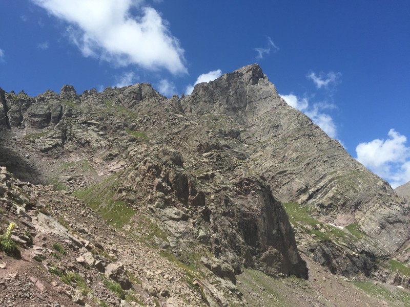 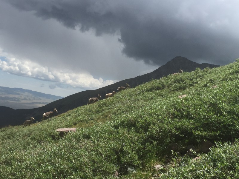 The Hike OutI would have been happy to climb into my tent for a rest, but there was still work to do. The clouds were threatening and we had to pack up and get moving on the long hike back to the truck. And there was still just a little route-finding remaining as we had debated Friday on the merits of various "shortcuts". This time we chose to cross the creek to the Humboldt side immediately to shorten the hike. Most of us headed in a northerly direction for the crossing - a little out of the way but along a clear path. Andrew opted for a slightly more direct route and was waiting for us as we reunited farther along the route. From here, after surviving three days of tough hiking/climbing, the remainder of the hike should have been easy. Uh-uh. I found myself rushing just a bit to keep up w/ the others when one boot hit a root. Even as I lurched forward, I fully expected to regain my balance except that my 30+ lb backpack had a mind of its own. Torque took over, and down I went, @ss over appetite, the fall exacerbated by a man-made step over which I tumbled and twisted, landing on my backpack w/ my feet positioned in the air on the step above me. How did I just do that? I lay there in a bit of a pickle, unable to immediately right myself before the others who had heard some of my choice words came back to investigate. The indignity. I took a second or two to make sure everything was still in working order and continued on, slightly banged up, but mostly just feeling stupid. However, I had just learned a valuable lesson in backpack physics. The return hike of course seemed about twice as far as the walk up two days previous and we probably were within a mile or so of the truck when the rain started. Mikel, who was not with us on Friday, reported that he had noticed a truck in the lot with a fence around it. "Mikel", I replied, "if you're hoping for a ride to the 2WD lot, you'll have to help remove said fence!" At the outset of the trip during initial fence set-up, everyone had kept a safe distance, seemingly regarding me and my strange contraption w/ a curious skepticism. Now, w/ an intensifying afternoon deluge a great motivator, everyone pitched in to pull out, unhook, disengage, decouple, take down, and roll up my dumb fence. I think the sharp edges may have drawn some blood here and there. We threw it and as many packs as possible into the bed, organization playing second fiddle to speed, and five wet guys packed into my truck for the final leg. Due to space constraints, Mike, riding shotgun, held my small cooler w/ water and ice jostling about on the rough road and I challenged him to balance it so as to minimize the sloshing sounds, which led to speculation about his ability to circumcise a baby under similar conditions. We were probably feeling a bit slap happy at this point.   I'm All About that Burger, 'bout that Burger, 'bout that BurgerMy primary motivation for climbing these rugged and treacherous behemoths is so I can fantasize about what I'm going to eat when I get back to civilization. And I think about it *alot*. It was especially difficult on this outing having to endure four hikes and two nights before I could gorge myself on a grotey cheeseburger and fries. This time, I needed to consume a Carl's Junior burger in Florence before thoughts of same consumed me. When I passed Carl's on the way down on Friday, I looked forward to returning there in 48 hours or so, all safe and sound, mission accomplished, to commune w/ my greaseburger. Florence was a good hour away, so the first gas station in Westcliffe would have to hold me over 'til then. There I nabbed a Gatorade, chips, and snickers bar which I finished off in short order, and continued on in great anticipation of my arrival in Florence and the fine feast that awaited me there. At long last, licking my chops like my dog when he sees me reaching into the box of Greenies, I pulled into the suspiciously near-empty parking lot. There on the drive-thru kiosk was verbiage on a handmade sign - and confirmed by a voice over the intercom - indicating that Carl's Junior was CLOSED. The electricity had just gone out on the entire street. It was gone from me as well. Tragically, there would be no burgers in Florence on this day. Knowing that my culinary cravings would go unfulfilled until at least the outskirts of Colorado Springs, I was forced to suffer another hour of psychological torture. Eventually however, I was sitting down to dine at The Best Burger King in the World reveling in a BK Whopper w/ cheese, upsized fry, and Coke. There may have been some onion rings. Thank goodness for life's simple pleasures and the simple people who enjoy them. Comparison TimeThe Needle vs The Peak The Peak was mostly straightforward in terms of route-finding. The biggest danger I think is in returning back over Broken Hand Pass before lightning hits. The Needle is steeper, with the Dihedral providing the greatest test, and of course you have to find the West to East Gully crossover point on the descent in order to avoid some very dangerous terrain. Also straightforward - as long as you take a good mental snapshot of the crossover on your way up, and clouds don't obstruct your vision on the way down. The Needle is perhaps the more dramatic of the two and it was a relief to only have to ascend Broken-Hand Pass once - which rendered the Peak more exhausting. If I was just doing one of them, I would choose the Needle - but both were spectacular. Wear a helmet in either case and go with a partner or two. The Needle/Peak vs other Class 3 (and 4) Everyone of course reacts differently to a given route, and my own response to steepness and exposure has changed w/ experience. My first trip up through the Keyhole on Longs overwhelmed me a bit as that route is so varied and it gave me my first taste of real exposure. But on my second attempt a year later, it was much easier. I might compare the Peak to a more solid Longs' Trough, and the Needle to Longs' Homestretch - if slightly steeper but with more and better holds. After Longs and a sampling of some technical climbing, Kelso Ridge and Wetterhorn really didn't bother me too much, though I remember feeling tense on Kelso Ridge because I didn't know what to expect and there was no turning back. Wetterhorn was just a good time. The Needle/Peak are maybe a step up in terms of steepness (though Kelso Ridge had its moments), but I thought there was less exposure than on Longs, and the Crestone hikes are shorter than Longs provided you choose to camp at the lake and do the two separately. That said, I still had a moderate case of the willies as I contemplated the climb of the Peak and especially the Needle, but I think I owe that primarily to a fear of the unknown, and the vagaries of the ever-changing and unpredictable high mountain weather. I feel like if the weather gods could *guarantee* that the day would remain perfect, then these and a lot of other 14ers would simply be a long exhausting hike - a fun quest with only a minimal intimidation factor. My other big fear besides the weather is rockfall as it's a challenge to manage this objective hazard. All of the climbs mentioned above feature pretty solid rock on their steeper sections, but I would remain on extra high alert on the Peak and Needle simply because of the verticality which is more sustained than the others. Sure, it's pretty solid, but it's all going to come down eventually. Finally, as one more frame of reference for those familiar w/ the Flatirons, I started seeking out some Class 3 and 4 climbs around Boulder to prep for the tougher 14ers and found the Second Flatiron an engaging and valuable training ground. It's most basic route is considered Class 4 or even very low 5 but has almost no danger of rockfall, has only a few hundred feet of elevation gain between 6-7K, and thus weather is essentially a non-issue (though I would never do it wet or icy). As feature-rich as the Second is, I think the climbing is a good notch above the Crestones in terms of difficulty and exposure. I did the Second unroped as most folks tend to do, so it prepared me well from a climbing standpoint. If you've done the Second, the Crestone climbing should come easily. If you haven't, check it out - with someone who knows the route as it's not trivial. For most peakbaggers, I recommend working your way up to these mountains through a progression of easier peaks first as you *might* be in for a shock if you jump too far ahead. But if you've checked off Longs, Kelso Ridge, Wetterhorn, or are just a well-prepared hardy soul, then you'll likely be fine on these two. Really, if you're acclimatized, reasonably fit, know the route, and have favorable conditions, the rest is mostly psychological. On Backpacking and What's Next?I've decided I like backpacking and I lament the fact that I waited this long to figure that out. The idea of efficiently packing everything you need into as small a bundle as possible and transporting it on your back has a certain appeal. I learned to hang a bear bag, filtering water was almost entertaining, and heating the water in the small jetboil for some delicious dehydrated delicacy was delightful. I envy the enterprising folks who can plan and execute a four course meal in the backcountry. I've been reading various trail travelogues (and seeing the movies) w/ great interest, but I don't think I'll ever be a PCT/AT/CT hiker and will just continue to live vicariously through others' accounts. However, while I backpacked in this instance in order to nab a peak, I *might* consider doing it again just for the sake of backpacking - to wake up in a beautiful, remote location (w/o a 4 AM wakeup time), and just chill. Read, explore, whatever. As it is, I'll continue to do it out of necessity as I entertain thoughts of Chicago Basin next summer, and I'm now better prepared after my Crestone experience. I know that the images conjured up in my mind are far more romantic than the more realistic "what was I thinking?" that is surely guaranteed if/when I get there. But still. I can already taste the Burger and Beer that await me on the Durango-Silverton narrow gauge upon my return. I can hardly wait. Thumbnails for uploaded photos (click to open slideshow):  The Crestone Needle and Peak")
 Broken Hand Pass (right of center) and South Colony Lakes. Taken from Humboldt 7/4/14.")
 2:36p. The drive into Westcliffe on Friday w/ an ominous storm brewing. Beautiful really.")
 4:27p. The other three in our fearsome foursome and my incarcerated truck.")
 Beware of bare ground as that's where the water goes. And the trees like to give off sap.")
 6:11a. Sunrise from the approach to Broken Hand Pass.")
 6:12a. Early morning glow cast upon BHP.")
 6:29a. The middle finger on Broken Hand Pass seems to be fully functioning as it concedes round one.")
 6:35a. On BHP. This one reminds me of the")
 6:37a. My first good look inside the south side of the Needle. Exhilarating! Will attempt the next day.")
 6:40a. Cottonwood Lake at the base of the Red Gully which rises up to the right.")
 7:15a. From Cottonwood Lake looking back up to BHP in the notch upper left.")
 7:21a. Quilted wildflowers near the lake.")
 7:21a. The Red Gully rising up in the middle. My spirits were elevated as I gazed upon this feature for the first time. Here")
 7:59a. Up close and personal in the Red Gully.")
 8:03a. Conglomeratic mosaic. Some component parts over a billion years old. Assembled 300 million years ago. Now, once again,")
 9:31a. Almost there. The Great Sand Dunes upper right. The Blanca massif and 3 more 14ers in back.")
 9:51a. On the Peak. Me w/ KC and a Band of Sunshine. (KC = Kit Carson 14er off left ear).")
 10:02a. Mike getting number 56! And tiny people on the Needle upper left.")
 10:30a. Don't forget the small stuff. Hoping my wife will paint this one for me. Or I'll enlarge it and hang on my wall.")
 11:34a. Neil getting just the right angle on his photograph looking up the gully.")
 11:49a. The Peak to Needle traverse is up there somewhere. I could prolly do it. Good thing it scares me.")
 5:41p. Slushes anyone?")
 7:21a. The shadow of the Roman soldier (just left of center) in the East Gully.")
 11:02a. (on way back). The gap. Looks worse in the picture than it is but it caught me by surprise.")
 8:07a. Mike heading up the East Gully.")
 8:29a. Mike at the Dihedral w/ a Nashville Cat contemplating the jaw-dropping cross over.")
 10:15a. (on way down). The others in our climbing quintet. Cats, Mike, Mikel.")
 10:27a. (on way down). Mike pointing out the best footholds.")
 10:27a. (on way down). The Cat's left foot on the best step, just a whisker from a hop to safety w/ the right.")
 10:24a. (on way down). Mike coming down from the fin that separates East/West Gully.")
 8:38a. Man is small. The mountains are big.")
 The green hanky (middle) was a timely discovery for my allergies. I pocketed it for later use. Not really. I didn't really")
 9:03a. Mikel/Mike in a representative shot of the climb up the West Gully.")
 9:25a. Take a peek at my peak shot on the Needle with the Peak in the background ... if your interest is piqued.")
 Majestic Humboldt 14er that I nabbed in 2014. Such a clean profile relative to the Crestones.")
 12:14p. Under the watchful eye of The Needle ... under sunny skies ...")
 12:35p. ... and 20 mins later, the goats (or big horn sheep I guess) heading off to seek cover from impending storm.")
 4:43p. Mikel evidently stayed in a Holiday Inn last night!")
 4:29p. A rainbow. A fitting finish to my adventure weekend!")
|
| Comments or Questions | |||||||||||||||||||||
|---|---|---|---|---|---|---|---|---|---|---|---|---|---|---|---|---|---|---|---|---|---|
|
Caution: The information contained in this report may not be accurate and should not be the only resource used in preparation for your climb. Failure to have the necessary experience, physical conditioning, supplies or equipment can result in injury or death. 14ers.com and the author(s) of this report provide no warranties, either express or implied, that the information provided is accurate or reliable. By using the information provided, you agree to indemnify and hold harmless 14ers.com and the report author(s) with respect to any claims and demands against them, including any attorney fees and expenses. Please read the 14ers.com Safety and Disclaimer pages for more information.
Please respect private property: 14ers.com supports the rights of private landowners to determine how and by whom their land will be used. In Colorado, it is your responsibility to determine if land is private and to obtain the appropriate permission before entering the property.