| Report Type | Full |
| Peak(s) |
Kun - 23218 Stok Kangri - 20182 Nanga Sago - 18950 |
| Date Posted | 11/15/2015 |
| Modified | 11/03/2019 |
| Date Climbed | 09/07/2015 |
| Author | astrobassman |
| Indian Himalayas (Kashmir and Ladakh) 2015 |
|---|
 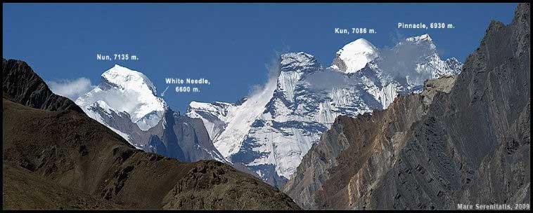 When I hear the word Kashmir I picture an exotic land filled with tension, mountains, and mysticism; that and the riff from the Led Zep song. So certainly the idea of going to this place and climbing some mountains seemed like a good idea. My original plan this year was to go to Tibet with some friends to climb Cho Oyu. The devastating earthquake in Nepal in April ended those plans. Having the time off already approved I explored other destinations, and not being able to recruit anyone to join me for a backup trip I decided to go to India by myself to explore Ladakh and Kashmir. India was dirt cheap compared to what Nepal offered, and the mountains and culture seemed just as appealing. I booked a flight to India for a month, the plan being to explore Ladakh for the first week while acclimating on easy lower peaks by myself, and then join an Indian expedition the last few weeks to 7086m Mt. Kun of the NunKun massif of the Zaskar Himalayas in Kashmir. Today Kashmir includes the Indian administered territories of Jammu and Kashmir (which consists of Jammu, the Kashmir Valley, and Ladakh), the Pakistan administered territories of Kashmir and Gilgit-Baltistan, and the Chinese-administered regions of Aksai Chin. Much less known to me was Ladakh, which means "the land of high passes". Ladakh is a region in eastern Jammu and Kashmir that extends from the Kuen Lun mountain range to the main Great Himalayas to the south. Ladakh is bordered with Tibet and as such the majority of the inhabitants are people of Tibetan heritage. Ladakh is a Buddhist land. 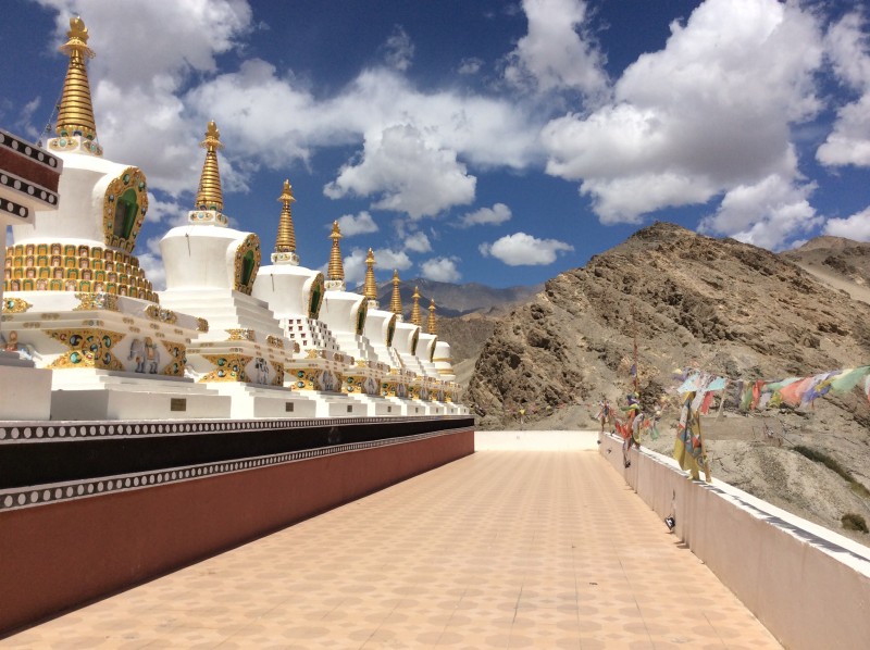 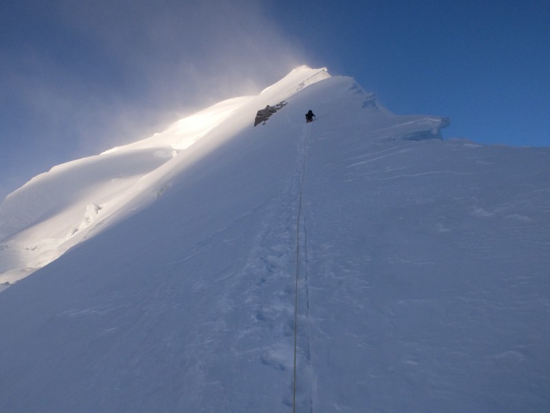 I left Denver on August 12. The Newark-Delhi flight that night was cancelled after sitting on the runway for 5 hours. After exploring NYC the next day, I made the flight to Delhi the next night. Unfortunately United lost one of my bags in the process. Also being delayed a day really put a kink in my plan. India operates a very formal approach to climbing their mountains, especially if you are a foreigner. Foreigners climbing 7000m peaks require a briefing in Delhi with the India Mountaineering Federation (IMF) and also require an IMF supplied Liaison Officer to participate in the expedition. With my flight being delayed I missed the briefing with the IMF. Then the day I did get to Delhi it was the India Independence Day, and then a weekend followed, so I would not be able to meet with the IMF for 3 more days. My flight to Leh in Ladakh was the next morning. I did not want to sit in Delhi for 3 days, so I decided to maintain my schedule, fly to Leh, and then fly back to Delhi a week later for one afternoon to meet with the IMF before I joined the expedition to Mt. Kun. The modified plan worked, but cost me another $500 and needless travel. Lesson learned is to not have such an inflexible itinerary, especially if you are flying United. My bag being lost was the other big problem. I would not be in Delhi to easily get the bag once United finally got it there. The Delhi airport told me it would be put on a flight to Leh when it came, but I was skeptical. Getting the bag proved to be the most difficult part of the trip. Every morning and night the first week in Leh I had to find an internet shop that had a phone and call the Delhi airport and United to figure out where my bag was, and some days take a taxi to the Leh airport to see if the bag was there. On a given day one person would tell me the bag was still in the USA, another would say its in Delhi, and a third would say the bag flew to Leh. The missing bag had most of the gear I needed for Kun. I figured I could get by on the first two peaks in Ladakh with replacement gear found in Leh, but if the bag did not come before Kun I would go home. The flight from Delhi to Leh only took an hour and had amazing views of the Himalayas. I had a window seat and picked out two high 7000m peaks - Kemet and Nanda Devi towering over a sea of lower mountains. Leh is a high-desert city known for its Buddhist sites surrounded by the Himalayas. Leh felt much more Tibetan than Indian. Massive 17th-century Leh Palace, modeled on the Dalai Lama's former home (Tibet's Potala Palace), overlooks the old town's bazaar and mazelike lanes. Leh sits at 10,500 feet so it is a great place to acclimate before heading to the high mountains. The first day in Leh I walked around and explored the city and the palace, and also a Buddhist shrine called Shanti Stupa. Scenes of Leh   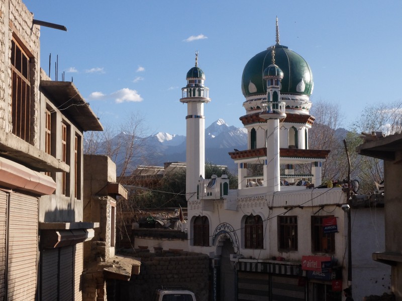  Stairs to Shanti Stupa  Shanti Stupa   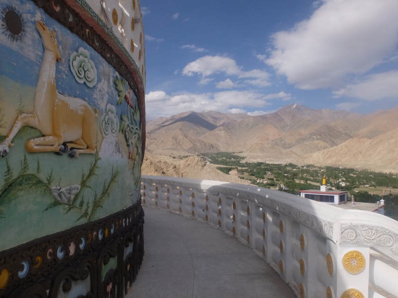  The second day in Leh I explored access to my first mountain objective, a 5,776m (18,950') peak above Leh called Nanga Sago. Nanga Sago is not the most impressive mountain or the most pleasant to ascend - think the Sawatch of the Himalayas. But it turned out to be a great peak to acclimate on. Nanga Sago is best accessed from the road that goes to the Khardung-La pass (one of the highest paved passes in the world at 17,582'). On this day I took a taxi and stopped when I saw a nice valley I could hike up that would give me access to a subsidiary ridge that I could take to the main ridge and follow that to the summit. I estimated where I started at on the side of the road was about 14,000', so it would be a stiff 5,000' ascent to the top. That first day I hiked up to around 16,000 feet in my city clothes to explore the route. I ended up getting blisters but it felt good to stretch my legs after all the traveling. City hiking gear  After I got back to the road I hitched a ride back to town with a truck that was decorated with Buddhist art and pictures of the Dalai Lama. The driver dropped me at the Tibetan market, where I shopped for items I was missing due to the lost bag to support my ascent of Nanga Sago the next morning. To my surprise I found an amazing pair of boots, sized EU 47 (my size - which is rare to find in Asia). I tried them on and they fit well. The cost was equivalent to $7. I continued wearing these boots after my bags were found and they are now my favorite hiking boots. I also picked up an old down jacket for $10, some 50 cent gloves, and a few pairs of 25 cent "Everest" socks and a free hat. With this I had enough gear to stay warm and comfortable for the Ladakh peaks. On August 17 I got up at 4am and after a large breakfast of eggs and bread my pre-arranged taxi took me to the side of the road that I had scoped out the day prior. I started hiking and quickly got to the previous day's high point. After this I slowed down a bit as the talus got steeper and looser and more annoying. The last thousand feet I slowed even more as the lack of oxygen started getting to me. The weather was holding, albeit windy and a little cold. My cheap gear kept me warm enough though. Towards the top of the ridge there was some scrambling on large lose rocks on top of snow. I topped out in the early afternoon where I finally had a view to the north, where I was hoping to see the see the giants of the Karakorum. I couldn't see anything obvious but I did pick out a pyramid on the horizon, thinking maybe it was K2. K2 was only about 100 miles away. K2 or not the views were amazing and it felt good to reach the summit of Nanga Sago. After a few minutes I started the decent. First windy and cold, then in the afternoon sun at lower elevations extremely hot and dry. After preserving my water I got back to the side of the road and after 15 minutes a group of bikers came by and one of them picked me up. The 45 minute ride down the windy mountain road on the back of the motorbike was a perfect way to end the day. After the guy dropped me off he said "welcome to India". Back in town I had Kashmiri naan and tea as an appetizer and then beer and pizza on a roof top terrace restaurant. Nanga Sago Terrain    Nanga Sago Summit  The following day I took a rest day, exploring some of the other monasteries in the area including Hemis, Shey, and Thuksey. These places were extremely powerful and peaceful. The chanting monks at Hemis monastery were a site to behold. Hemis Monastery     While walking besides a stream behind the Hemis monastery I felt fully relaxed for the first time on this trip, the stress of tracking my bag escaped me and I decided whether my bags came and I climbed Kun or not it would be good.  There are myths, probably blasphemes about Jesus visiting Kashmir and the Hemis monestary during the period of his life between ages 12 to 28 where there is not much record of what he did. The connection of Jesus to Kashmir was found by the Russian Traveller Nicolas Notovich who stumbled on a Tibetan Scroll in the Hemis Monastery in 1887. Monks described Buddha Isha who preached the holy doctrine in India and Israel. Shey Monastery   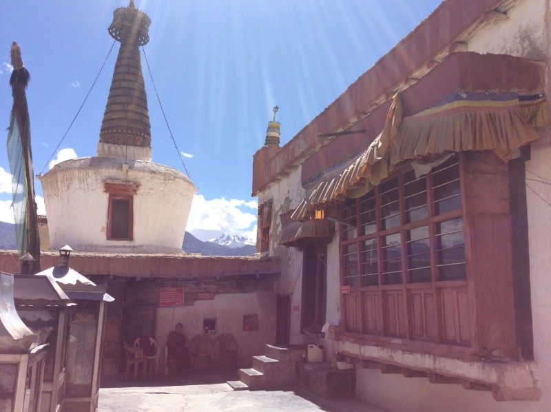 After returning to Leh I went back to the one mountaineering shop I had found that had plastic boots in my size. These were terrible old boots but I thought they would be preferred over the hiking boots on Stok Kangri. I also rented an ice axe and some snow pants. Most people trek Stok Kangri in 4 or 5 days. I felt fairly acclimated so my plan was to do it in 2. The people in the mountaineering shop said it was not possible to hike from the trailhead (the village of Stok) to the high camp in a day. It was too long. When I got to Stok the next morning the person collecting fees to climb the mountain said the same thing. I started around noon and reached high camp by 6pm. Living in Colorado really toughens you up when compared to the average trekker visiting Ladakh I suppose. The hike in was other-world terrain of desert and mountains. I passed two camps along the way which I considered staying at. But high camp at 16,000+ feet was the goal. About an hour before high camp I came upon a horse driver heading up, so I decided to throw my bag on the horse for a small fee. My bag was not too heavy but not trivial either, so this saved some energy for the summit climb later that night. My plan was to get dinner at the "teahouse" at high camp, and sleep under the stars unless a tent was available to rent for the night. Luckily I arrived in time for dinner and they had a big tent I could sleep in. I met some friendly people in the teahouse who were also going for the summit that night. Stok Kangri is a popular trekking peak for people with not much mountaineering experience, as it is advertized as one of the easiest 6000m peaks in the world. The hike in to Stok Kangi    Stok Kangri High Camp  I didn't sleep too well that night as this was the first time sleeping higher than Leh. I heard most of the groups leave around midnight. I got going around 2am. It was a little lonely wandering up the mountain alone in the middle of the night. After an hour I crossed a pass and headed down towards the glacier. I passed a few people and started walking up the glacier, which did not have any significant crevasses. It eventually got steeper but there was a well defined path in the snow. Around sunrise I found myself in the company of the group from the previous night. Inge from Holland, Aleister from Canada, and Israel from Israel. I climbed with them for a while until we got to a high col. All the groups were roping up for the final ridge to the summit. They asked me if I wanted to rope in with them and I said sure, although in hindsight I'm not sure if it was a good decision because if someone fell I was not confident in our ability to arrest. But I had a great time with this group the next few days which was nice since I had been by myself most of the trip so far. Sunrise  Summit Ridge  Inge and Aleister at the col  The final ridge to the summit was easy - a little easy class 3 with moderate snow climbing and some moderate exposure. Something that would be soloed without much thought in Colorado. We were one of the first groups on top. Large prayer flags adorned the summit. It was a perfect clear morning without much wind. Another group approaching the summit   Me on the summit  We took in the views and stayed up top for a half an hour before quickly descending. I got a nice long glissade in below the col. Back at high camp before noon my original plan was to hike out and head back to Leh that day, but I was so relaxed in the mountains and enjoying the company of my newfound friends, that and they sold beer in the high camp cook tent, so I decided to stay another night. It was a good decision. The next morning I hiked down the trail and got back to the trailhead around noon, making for a 48 hour roundtrip. Upon returning to Leh I heard from 3 sources (Delhi airport, United, and Air India) that my bag was in Leh. This seemed positive. The next morning I went to the cargo truck at the airport and sure enough the bag was there. So I could go to Kun after all. I flew back to Delhi that morning for the IMF briefing. Before the briefing I went on a tour of Delhi. I saw some of the highlights of the city - a rickshaw ride through old Delhi, the red fort, Gandhi's grave, the government seat, etc. I then went to the IMF, where I met my liaison officer Nizam. Based on the books I have read I expected the liaison officer to be someone who would sit in base camp all expedition with no interest in mountaineering. Contrary to this Nizam had extensive climbing experience, having climbed several Indian 7000m peaks, including Kamet (7756m) three times. He had climbed Nun twice but never Kun so he was excited to give it a go. After filling out lots of paperwork with a low level IMF official we met with a senior IMF official where we discussed the specifics of the exhibition and contingency situations. After the meeting I went to the Imperial Palace hotel where I enjoyed Gin and Tonics all afternoon and then fish and chips. It was old world British Imperial style. This place is a 5 star hotel and at only a little more than $100 a night if felt like a deal. Delhi (rickshaw ride, government seat, Gandhi's grave)    IMF    The next day, August 23 turned out to be a marathon travel day. I ended up going from Delhi all the way to the road stop where you start hiking to Kun base camp in Kashmir. Early in the morning I caught the flight back to Leh. By then I was used to the Delhi-Leh flight routine. After landing I met the taxi driver Ali that I got to know the previous week. He had brought his son along for the journey as well. After loading up my gear and picking up a few odds and ends we started the 6 hour drive from Leh to Kargil. The high altitude desert terrain along the Indus River was mesmerizing.     We crossed a few high passes along the way. After the last pass all the monasteries and prayer flags gave way to Mosques and signs were now written in Urdu (official language of Pakistan). We had left Buddhist Ladakh and were entering Muslim Kashmir. Every hour or so there would be a checkpoint where I had to show the Army my papers and passport. There were signs along the way that said things like "Time is money but life is precious" in order to get people to not speed on this treacherous road. We arrived in Kargil mid afternoon. Kargil is very close to Pakistan. There was a war here in the 90's between Pakistan and India. Kargil was not a pleasant town. I heard that old Buddhist monks in Ladakh wished upon their worst enemies to be reborn in Kargil in their next life. In Kargil I met up with the expedition. They had come from Srinagar in Kashmir the day prior. Everyone wanted to get on with it, so after a few hours in Kargil we loaded up our gear onto the top of a van and started the 5 hour drive up the Suru valley to the village of Shafat where the hike to Kun base camp begins. The distance was only 50 miles or so but the road was so bad that the driver could not go faster than a few miles per hour. Along the way we got our first view of Nun and Kun at sunset. Nun (center), with Kun on the left  We arrived in the village of Shafat late at night. The village is only inhabited in the summer, and consists of just a few houses and a police station. Some tents were already set up by the 3 Sherpas who had gotten there earlier that day. After some noodles I got in my sleeping bag and went to sleep. The first real day of the expedition, August 24th, was a rest day. I was acclimated and rested and would have preferred to aggressively climb Kun in a week if possible, but I was along for the ride at this point as I could not go off and climb Kun by myself like I did on the easier mountains in Ladakh. I got to know my expedition teammates better this first day. The expedition was organized by a group out of Delhi called Alpine Wanderers. We were part of an expedition with the Indian Navy that were to be a few days behind us. They provided transportation to/from the mountain, all food, tents, group climbing equipment, and 3 Sherpas who did the heavy lifting. The three Sherpas were all from Darjeeling India. Nima Sherpa, the lead Sherpa, had climbed Everest 8 times by 3 different routes is what I think he said (I did not catch what the third route was), and was the only one of the group who had climbed on Kun before. Thumba Sherpa was the old sage Sherpa who had climbed extensively in the India Himalayas. Pemba Sherpa, only 25, was trying to prove himself and had climbed Nun in July. He invariably got assigned all the grunt Sherpa work. Nizam the Liaison Officer, who is in his 50's and is in the Indian Air Force when not in the mountains. There was Roushin, late 20's, a software engineer from Delhi. I really enjoyed Roushin's company. There were two other guys Kavin and James, from Delhi and Mumbai, and there was a lady climber everyone called "madam". There were also lots of cooks and other helpers that went to base camp. There was a representative from Alpine Wanderers who was responsible for the logistics of the expedition. There was varying degrees of experience, from multiple 7k and 8k meter summits to barely being above 5000m on non-technical trekking peaks. Everyone got along well enough and it was nice to get to know all these interesting people from India. At lunch that day I thought the food was pretty bland, so someone offered me some chili sauce, but warned me to only use a little. I had a little taste and thought it was weak sauce, nothing compared to stuff I've had back home. So I doused my plate with it. It tasted fine going down. No less than 5 minutes later I became ill. I spent the afternoon getting sick. I wondered off at one point sick of lying in the tent, and some local shepherds came up to me. One spoke some English and we talked about our backgrounds and he told me how lucky he felt to live in this remote valley in the mountains of Kashmir. He was genuinely concerned about me being sick and offered some medicine. It was a nice gesture. I went to bed that first night of the expedition feeling terrible with the chills, and missing home and the wife terribly. Thankfully my health and spirits were improved the next morning. Shafat (the village where the walk to Kun base camp begins)   The second day we packed everything up and moved camp an hour up the valley. It was ridiculous in my opinion to only move camp one hour, but all the locals who owned the horses that carried our gear to base camp refused to go any further as the route from there to base camp was through rough moraine and they didn't want to go that far in one day (although it would have been pretty doable in my opinion). For snack that afternoon they fried up potatoes which I ate as many as I could. That night there was singing after dinner which was nice. Walking up the valley towards Kun basecamp   Valley Camp   The 5000m craggy peaks above us were intimidating  The third day we marched on to base camp at around 14,000 feet. The terrain up to base camp through the moraine was rugged. Along the way we made cairns as the trail was not obvious.  Approaching and setting up base camp. Avalanches roared down some of the nearby peaks on the way in.     Base camp was a very comfortable camp. Warm, with water running nearby. There was also a German expedition camped a few hundred feet away, but all the climbers were high on the mountain when we got there. Other than that we had the place to ourselves. I was lucky enough to get my own tent. Base Camp   A room with a view  Every afternoon in base camp I would lounge around reading books and listening to music. Before dinner I'd have a little happy hour with the bottle of fine Scotch I brought all the way from USA (Talisker). I read 3 books on this expedition. One of my favorite parts about expeditions is the down time where I get to read, as I don't get much of that at home. That first night in base camp at dinner everyone tried to teach me basic Hindi words and phrases. It was hilarious to them to hear me try to pronounce the words. The next day (day 4 - August 27) we made a carry to camp 1. Camp 1 was at around 16,000 feet. Being acclimated it was a pretty easy day for me, arriving in a little more than 2 hours right behind the Sherpas, several hours ahead of the rest. To climb Kun you first have to get to a high plateau at 20,000 feet. Getting up to the plateau is probably the crux of climbing Kun. There are a few ways to get there. The traditional way has camp 1 on the glacier at around 17,000 feet right below the 2,000 foot 50 degree face, camp 2 at the top of the headwall, and camp 3 at 21,000 feet at the far end of the plateau. This approach makes for a long day from base camp to camp 1 that requires glacier travel, but makes it much easier getting up the crux headwall. Our camp 1 was on rocks above the glacier yet several hours from the bottom of the headwall. The advantage of placing camp 1 here was it was just mostly walking on talus to camp 1 and there was running water at the camp 1. The downside was that it was too far to get to the traditional camp 2 from this camp 1 in one day. Base Camp to Camp 1   Camera acting up and changing settings on me. My new camera did this often. All the black and white photos were not intentional, but they came out OK.  Getting used to the diet was one of the the more challenging parts of the expedition. All Indian food, and specifically all vegetarian every day. The food was pretty good, just different. The conversations at meals were always fun and lively. It was very different than all the off-color humor when on trips to the mountains with my friends in Colorado. Day 5 was a rest day at base camp where we organized gear and relaxed in the sun. The base camp cook Tiger was a friendly and funny guy from Manali. Every morning in base camp he served tea while we woke up in our tents. I have not experienced such luxury on expeditions, but I got used to it quickly. That night at dinner I was very firm in that we needed to place wands on the route from camp 2 to camp 3. The route is across the big plateau above 20,000 feet, where it would be impossible to not get lost in a whiteout without wands (no one had a GPS either). Thankfully everyone agreed and we found some material to make some wands the next day. Tiger with his tea kettle  On day 6, August 29 most wanted a rest day. I was feeling pretty good and wanted to stretch my legs so I carried a load with the Sherpas. I kept up with them for the most part and Pemba Sherpa complimented me and said I was very fast, again another benefit of living and training in Colorado is a Sherpa saying you are fast (I am average speed at best amongst my friends). That night the Sherpas stayed in camp 1 while I headed back down to base camp. After returning to base camp it was very warm and sunny and everyone was really upbeat. I took an alpine bath in the nearby stream and relaxed all afternoon. On day 7 we moved to camp 1. I did not sleep well the night before (kept losing my breath and waking up) and woke up with stomach problems. I had promised madam that I would go with her and help her across the snow on the way to camp 1. It was nice going at this relaxed pace especially because I was not on my A game that day. James and Roushin were a bit behind and at one point James' sleeping bag fell off his pack into the stream but thankfully Roushin noticed this and retrieved it for him. After arriving at camp 1 it was very windy and we quickly set up the tents. Camp 1 on a different day with better weather  Day 8 the weather was really bad and we could not do a load carry as planned, so we rested, spending most of the day in the tents. I had again slept terribly the night before and was cold, had stomach pains and shortness of breath. The day after the Sherpas carried a load up to camp 2. I wanted to join them but instead decided to stay at camp 1 to help with climbing skills with my teammates. Right above camp 1 is a 45 degree ice slope. Climbing on this type of terrain was new to some so we spent the day starting with basic crampon techniques and then moving on to ascending and rappelling the fixed ropes. On day 10, September 2nd we got up early with the intention of moving to camp 2. Typically before I move to a higher camp I like to carry a load there first if possible, so I was not sure how this day would go for everyone. This day proved to be the most challenging of the expedition except for summit day. After ascending 100m of the ice slope above camp 1 the route traversed across a mostly level glacier with big open crevasses. The view of Nun along the way was imposing. Camp 1 to Camp 2   After the glacier traverse the route dropped down to the basin below the headwall. There was no tying in here as the large crevasses were big and obvious and easy to get around. Basin in between Camp 1 and Camp 2. The headwall to the plateau is seen on the right with Nun looming over in the center.  The higher we got the better the views became  The problem was when we reached this basin it was around noon and it was unbearably hot. We had been going for 4 or 5 hours already, and then we had to start the crux of the climb, the 50 degree snow/ice headwall in the early afternoon. It would have been nicer to start earlier in the day when better rested. I was behind the Sherpas by an hour or so but ahead of everyone else by a good bit. I started up the headwall, first in heat and then an hour later windy and cold. My pack was pretty heavy so it was challenging. Towards the top the slope was hundreds of feet of 50 degree ice, which really took it out of me (much harder than the equally steep but mostly snow lower on the face). After 1000 feet of climbing the face I reached the ridge where modified camp 2 was placed at ~19,000 feet. I was pretty exhausted at this point. As I unpacked my gear Thumba Sherpa went down to go see if he could help the rest of the climbers. He came back carrying madam's pack, and an hour or so later Roushin and Nizam came up (carrying their own packs). I took madam's crampons off for her and helped her unpack as she was pretty wasted. We were all tired. Unfortunately James had turned around at the start of the ice headwall above camp 1 and Kavin had turned around in the large basin below the headwall to camp 2. While climbing the headwall I saw Kavin sitting in the basin for hours. Apparently someone promised they would go with him back to camp 1, but that never happened and he ended up going back alone. Later in the expedition the cooks told me how Kavin had told them how scared he was in his comical way traversing the glacier and descending back to camp 1 alone. Approaching Camp 2   Day 11 at camp 2 the weather was terrible so no one was moving. A rest day sounded good to me so I was happy with that. Camp 2 was somewhat of an exposed camp. Right behind our tent was a 1000 foot drop-off to a glacier behind the face. Out the front of our tent a fixed rope went by ascending the flattest part of the face. The tent I was in was separated from the tent with the stove, so I had to put crampons on to go the 20 feet between tents. We had amazing views of the mountains to the south, where I was told most were untouched (these peaks in Kashmir have been off limits to climbers). Weather day at camp 2  Roushin staying warm while Thumba Sherpa pokes his head out to check the weather. The steep slope above is the start of the route to camp 3.  Camp 2 in better weather   Camp 2 view out front of tent and back of tent   One of the cooks, Ali was really strong and went up to camp 2. Here he is doing an amazing job melting snow for everyone.  We decided to go directly to camp 3 at 21,000 feet the next day (day 13). The final 1000 feet of the face directly above camp 2 went much easier than before after the rest. Climbing the face above camp 2    Climbing up one of the little ice steps  Roushin enjoying himself  Once on top of the face we finally got our first close up view of the mountain we came to climb. Kun (7086m) is on the left and Pinnacle Peak (6930m) is on the right. The route to the Kun summit goes to the col between the two peaks and then turns left ascending the ridge to the summit.  Between us and the Kun was the large plateau that slowly rose from 20 to 21,000 feet over the course of a few miles. The plateau was an amazing place; miles of snow in every direction with craggy peaks above and clouds and other mountains poking above the horizon off in the distance. It reminded me of a beefed up version of the snowy mesa in winter in southwest Colorado.     After the long walk with a few ups and downs I arrived at camp 3 where I felt surprisingly good. It was the same routine, the Sherpas had gotten to camp by at least an hour before me. Some drama came here when half a mile out of camp 3 madam got tired and started screaming at the top of her lungs. Pemba Sherpa took off like a man possessed to go help. She was just tired, and Pemba came back looking frustrated while carrying her pack. That evening it lightly snowed while I focused on the vision of climbing to the summit of Kun. My preference was to go for the summit the next day and climb alpine style. But since the Navy expedition was coming behind us the Sherpas wanted to fix the route above camp to the col between Kun and Pinnacle Peak (6930m). So the next day, day 14 was a rest day for me. It was for the best because bad weather came in early that day. The Sherpas were only able to fix 200m or so above the camp. I did not think I would rest well or gain much strength at this height, but it turned out to be not that bad. We were all hoping for good weather the next day. Camp 3 (Nun in the background)  The following day, Day 15, September 7 was the summit day. The plan was for a 2am start. As such we got up at 1230am. I generally gauge how cold it is on a mountain by how painful it is to put on boots and crampons early in the morning (ie how numb my fingers get). This was painful on Kun, but not as bad as Pik Lenin last year or Denali or even the coldest winter days I've had in Colorado. I was out of the tent and ready to go at 2am, but unfortunately I was the only one. I stood around stomping in the snow trying to stay warm. After half an hour one of the Sherpas was ready to go so the two of us headed off together. It had snowed the night before so the tracks from the previous day were covered. We reached the start of the fixed ropes, clipped in and started climbing. There were some steep sections approaching 60 degrees not long after leaving camp and it felt good to be tied in here. After a few hours of steep climbing I reached the saddle, not far behind Nima and Thumba Sherpas, where we re-grouped. They wanted to go ahead and fix ropes up the traversing 45 degree snow/ice face. I did not object. I had not stopped to drink or eat anything since leaving camp so I ate a candy bar and drank some water and sat behind a rock outcropping out of the wind. The sun was starting to rise, and until this point I had all my layers on including down pants and parka, balanclava, and goggles. I had not gotten too hot climbing with all this so it must have been fairly cold. I had hoped to climb to the summit with Roushin and Nizam but they had not caught up to me yet, and I was getting cold, so I pressed on. Climbing up the traversing face was much more difficult and I slowed down accordingly. There was a few inches of snow on top of ice. The previous climbing had been very steep snow, but just snow. The good news was the slope was pretty stable and there were no avalanche concerns here. I slowly followed Nima and Thumba up the mountain, staying about 100 feet behind them.  Climbing the face with Pinnacle Peak (6930m) behind  Approaching the false summit  After a couple of hours on the traversing face we reached a false summit, at I'm guessing around 22,600 feet. Here I stopped and rested for another 20 minutes. At this point some of the others caught up to us. It was Pemba Sherpa and madam. Roushin and Nizam had turned around due to Roushin not being able to feel his fingers and fearing frostbite, and Nizam's boots were jacked up so his feat got too cold. I had to give it to madam; she was not the one I expected to still be climbing. I noticed Pemba Sherpa was pulling her up the mountain at times, which was very admirable of him. We pressed on making slow progress in the worsening weather. The views were closing off and we became engulfed in snow. Visibility was less than 100 feet, bad but not terrible by any means. The ice had transitioned to deep unconsolidated snow after the false summit. After traversing some level terrain we came upon a steep section that I was concerned with about snow stability, but Nima Sherpa was more confident in it than me so he led on and crested the steep slope without incident.  Once up that slope it was a short ways to the summit, probably 200 feet or less. But that 200 feet took us almost 2 hours. The snow was deep and we all moved very slowly. Nima Sherpa was in the lead, and after a while he came to a stop towards the top of a slope. It was hard to tell if this was the summit from where I was since visibility so low. He signaled for the rest of us to come up so we slowly did. We reached him and noticed we were at what appeared to be the top, well technically a few meters below the very top, but a large cornice threatened the true summit so we called it good there. It was 230pm. We had been moving for 12 hours. We were exhausted and it was good to rest for a few minutes. Once there was a slight break in the weather and I could see across to Pinnacle Peak (6930m), and we were far above its summit, which made me feel much better about being on the true summit. I had heard one can see Nanga Parbat from the summit of Nun/Kun, but the views today did not allow it. Last few meters  Nima Sherpa and Thumba Sherpa on the summit  Madam was really wasted and the Sherpas slowly helped her down the mountain. I was pretty tired too. I slowly rappelled the traversing face, which was awkward compared to a straight rappel. In some sections the rope was too tight to rappel so I very slowly down climbed, which took a lot of energy. Once back at the col the going became much easier as it was straight rappels all the way back to the level plateau. It was getting dark at this time. Two of the three Sherpas were taking rotations getting madam down the mountain. Once back on the plateau it was a few hundred meters of level terrain back to camp. The problem was it was pitch dark and all the tracks from early in the morning were covered in fresh snow. I was with Thumba at this point and we had a general idea on where to go so we marched off. We would stop every now and then to make sure we were not about to walk into a large crevasse. After wondering around for a bit, I decided to start calling out to camp 3. After a few loud calls a light came on off in the distance, and we could then see where to go. We got back to camp at 830pm, making for an 18 hour day. After topping off some water I went straight to my sleeping bag as I was pretty exhausted. Madam and Pemba and Nima Sherpas came back a few hours later. I slept well that night. My plan was to get all the way back to base camp the next day if I was strong enough. I got up at 7am and slowly packed all my ice covered gear. At 10am I was the only one ready so I started off. It had snowed a lot and I had to break trail, so I moved very slowly. I was not looking forward to breaking trail by myself for 2 miles across the plateau at 21,000 feet with a heavy pack after an 18 hour summit push the day before. Thankfully after an hour I saw someone coming behind me. It turned out to be Pemba Sherpa. He was going back to Camp 2. Pemba and I traded off breaking trail across the plateau. The wands did come in handy up here as they allowed us to stay away from crevassed areas. When we got towards the other end of the plateau the Navy team had just crested the face. They were very nice guys. At the edge of the plateau Pemba said he was going to wait for the others, so we said our goodbyes. I told him the spare crampons I had left at base camp were his and he was very happy about that. Packing up at camp 3  Breaking trail back across plateau  I quickly rappelled the upper part of the face and arrived at camp 2 where I collected some of the gear I had stashed and had a cup of tea and a Snickers bar. The weather looked like it was coming in so I pressed on as fast as I could and started the long rap down the lower part of the face. There were two Navy climbers coming up and we met in the middle of the face at an anchor station. They didn't speak much English but they sure wanted to talk. It was a funny situation, the three of us hanging there and trying to talk to each other. I was very happy they were coming up that day though because they put fresh tracks through the snow in the basin below the face, which was very helpful because there are some crevasses in that area that need to be avoided. After the last rappel off the face I started the walk through the basin. My knee slid in a covered up crevasse at one point, but I was able to quickly push myself out. After crossing the basin I slowly traversed the upper glacier and felt better as I was fixed into a rope at this point, but again sank into a crevasse and yanked on the rope and eased myself on. It was a bit unnerving. I reached the top of the ice slope above camp 1 and the rope was stuck in the ice. It was very difficult to get it free so I down climbed this section, bypassing sections I couldn't free. Towards the bottom I was able to free the rope and rappel the steepest part and then reached the safe ground of the rocks and walked for 20 minutes to camp 1. At camp 1 the cook Surge was very happy to see me and he cooked me up a big hot steaming plate of Indian food, which tasted amazing that late afternoon. Surge at camp 1  I collected the gear I had stashed at camp 1 and hung it lazily off my pack, which was enormous and monstrously heavy at this point. I slowly walked down to base camp. I slipped on a wet rock and fell in a stream in the lower basin at one point. I got soaked but I didn't care. I stumbled into base camp at sunset where I ate more Indian food which never tasted better and then fell to sleep. The next morning the base camp cook was frying up some donut type things and I ate 5 of them. He just kept offering them and I couldn't say no. I then took an alpine bath in the stream and relaxed and drank tea and talked with the two Indian Navy climbers who were stuck at base camp due to injuries/illnesses. One of the guys had climbed Everest a few years ago so he was pretty surprised he had gotten altitude sickness on this trip. Around noon Roushin, Nizam, and madam came into base camp. They had spent the previous night higher on the mountain. They were eager to head all the way out to the road that day. I was planning on relaxing in base camp that afternoon, but they talked me into heading out with them. We would have to hitch a ride back to Kargil. The walk out was pretty painful. There were no horses to carry our gear, but there were two porters at base camp, so we hired them. The problem was there were 3 big bags of ours for them to carry in addition to the heavy bags we were carrying. They weren't really able to carry all three so I took a lot of weight out of one of them and carried it, which made my pack monstrous again. It was a brutal hike out as my body was hurting. Roushin and I had some great conversations which helped pass the time though. At one point we heard madam screaming in the moraine. She wanted some help but we just sat there knowing that Nizam was behind and would get her going again. We finally reached the road at sunset. Not many vehicles passed by on this lonely Kashmiri road. The first one that came was an Indian Army jeep. The occupants looked very intimidating. No one except madam was very eager to catch this ride. Waiting for a bigger truck seemed like a better idea. There was room for one more though so I squished in. And I mean squished. I could not move my legs and my shoulders were pressed together so I didn't push the soldier next to me too hard. It was a terribly bumpy road and the drive totally sucked. After a few hours it became apparent that we were lost. We were high on some 4wd dirt road that seemed to be leading nowhere in the middle of the night. After backtracking and asking for directions in the one hut we came upon that had a light on, at around 3am we finally made it to some sort of Army barracks in a small village where there were dozens of other soldiers sleeping. They let us sleep in an extra room that had green goat shit on the carpet. As uncomfortable as it was I was thankful for the graciousness of the Indian Army to pick us up and let us stay there. Early the next morning we paid a local with a car to take us the rest of the way to Kargil. In Kargil we found Roushin and Nizam waiting for us. Not long after the Army jeep picked us up the previous evening they were picked up in a luxurious truck (as they described it compared to our jeep) that allowed them to spread out and it drove them all the way to Kargil the night prior. After a shower, Roushin, Nizam, and I hired a car and set out for Srinagar, the capitol of Kashmir. On the drive to Srinagar there was a lot of military activity. Along the way we passed the high altitude warfare center, the Camp Hale of India I suppose.  I was hesitant about Srinagar as I had read on the US State Department website to avoid this city at all costs, as there are regular terrorist attacks here. It emphasized grenade attacks, which sounded terrifying. But this was the nearest city with an airport. We ended up not having to spend the night here as we made it to the airport just in time to catch the last flight to Delhi. On the one hour flight back to Delhi the three of us discussed returning to the mountains of Northern India next year for an attempt on 7756m Kamet. It was really tempting to stay in Delhi a few more days and take Roushin up on his offer of showing me around more. But I missed home and missed the wife and the dog so I decided to fly back to the USA that night if I could. I changed my flight and soon enough I was on my way to Newark. I arrived home 2 days earlier than planned on Friday September 10. Going from the summit of Kun in the remote mountains of Kashmir to Denver Colorado in 3 days was quite a travel experience, and of course United lost my bags on the way home again. It was great to be home where I watched football and ate all weekend before heading back to work on Monday. Climbing with Sherpas was a really cool experience that I'm happy to have done. Even though they were expected to carry all group equipment and fix all ropes I felt I should have contributed with this hard work, and as such I would have liked to have carried more loads with the Sherpas than what I did. As I had heard many times before, I found the Sherpas to be amazing people, equally strong, empathetic, and friendly. Without them it would have been exponentially more difficult to climb Kun. I also truly enjoyed the company of my newfound Indian friends. I have never met an Indian I didn't like at home and this proved to be true in India as well. Some friends and I are already in discussions of a joint American-Indian expedition to Kamet next year, assuming we don't go to Pakistan for Gasherbrum II as previously planned. 7000m peaks in India are much cheeper than an 8000m peak and are definitely unique. As Robert Plant said of the song Kashmir: "the whole deal of the song is... not grandiose, but powerful: it required some kind of epithet, or abstract lyrical setting about the whole idea of life being an adventure and being a series of illuminated moments." Kashmir lived up to the imagination I had of it, illuminating and expanding, it was a great adventure. Thumbnails for uploaded photos (click to open slideshow):
|
| Comments or Questions | |||||||||||||||||||||||||||||||||||||||
|---|---|---|---|---|---|---|---|---|---|---|---|---|---|---|---|---|---|---|---|---|---|---|---|---|---|---|---|---|---|---|---|---|---|---|---|---|---|---|---|
|
Caution: The information contained in this report may not be accurate and should not be the only resource used in preparation for your climb. Failure to have the necessary experience, physical conditioning, supplies or equipment can result in injury or death. 14ers.com and the author(s) of this report provide no warranties, either express or implied, that the information provided is accurate or reliable. By using the information provided, you agree to indemnify and hold harmless 14ers.com and the report author(s) with respect to any claims and demands against them, including any attorney fees and expenses. Please read the 14ers.com Safety and Disclaimer pages for more information.
Please respect private property: 14ers.com supports the rights of private landowners to determine how and by whom their land will be used. In Colorado, it is your responsibility to determine if land is private and to obtain the appropriate permission before entering the property.