| Report Type | Full |
| Peak(s) |
Uncompahgre Peak - 14,318 feet |
| Date Posted | 09/11/2015 |
| Date Climbed | 09/04/2015 |
| Author | summit2sea |
| Uncompahgre in the Mist |
|---|
Another birthday, another great climb to mark the occasion. We left Denver Thursday morning in order to avoid any Labor Day traffic and were rewarded by an uneventful 6 hour drive. A lot of rain leading up to getting to Lake City, but upon arrival to the small Texas town (seriously, what's with all the Texans?), the rain let up and the sun came out. The drive up to Nellie Creek TH was no issue with my stock 4Runner, and the water level of all creek crossings was pretty low. The large rock that seems to be in most warnings for the first crossing was exposed and easily avoidable. Eventually we got to the TH and explored the area, and just to stretch our legs, walked up the trail a mile and back. Beautiful views of the Uncompahgre as soon as you hit treeline. It has been a long time since I have been almost buzzing with excitement about a mountain. I have climbed in the Front Range, Mosquitos, Sangre's, and Sawatch, but this was my first San Juan mountain and I think I have a bit of a crush on this three tiered, stand alone peak. Camp was set a little below the TH for a bit of a restless sleep in the back of the 4Runner, two people and a snoring 50 lb Vizsla pushed the limit of its capacity for being comfortable. None the less, we woke about 5am and with two other 4wd vehicles at the TH got on the trail while the weather couldn't decided if it was going to rain, sleet, or just mist. Within the first mile you could tell that either spring run off or some storm really washed out a portion of the trail. I briefly looked in the prior reports and couldn't see any mention of this so I do so here. The trail eventually merged with the Blue Creek Trail which coincided with Uncompahgre appearing from the clouds for the first time that morning.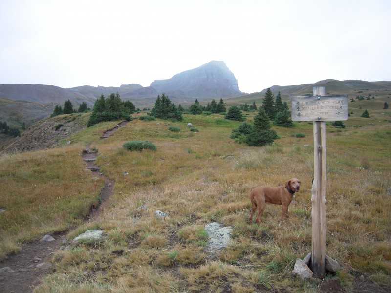 As we ascended higher, the mountain became more and more visible and I began to believe that we may luck out and have a clear peak. 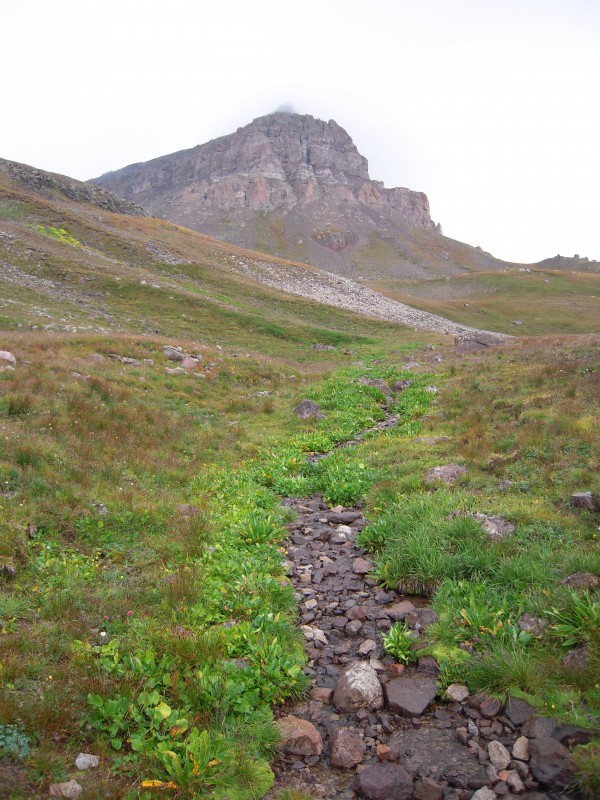 Then we ran into one of the groups ahead of us that had turned around after reaching the saddle. The mother/daughter team said there were some pretty dark clouds looming in the West and they were going to try to attempt the mountain the following day instead. Having been caught in high country storms where my carabiners are humming with electricity, I really am not one to mess with dark clouds. But what I was seeing at that point was more moisture than electrical storms. With the agreement that we turn around at the first flash and/or boom, we pressed on. We reached the saddle and overtook the other group that departed before us. A great group of four retirees (at least three of them were retired) from Arizona and Vermont. They apologized for their speed, and I could only hope that I'd still be climbing as well as them by that birthday. A blast of wind greeted us as we took in the view from the saddle. We were able to see what weather we might have in store, and while there were clouds, none looked like a deal breaker. Wetterhorn Peak was obscured by low grey and white clouds that spread out over the entire range. A quick pause to throw on our coats and down some GORP and we began to make our way up the switchbacks as the weather rolled in. 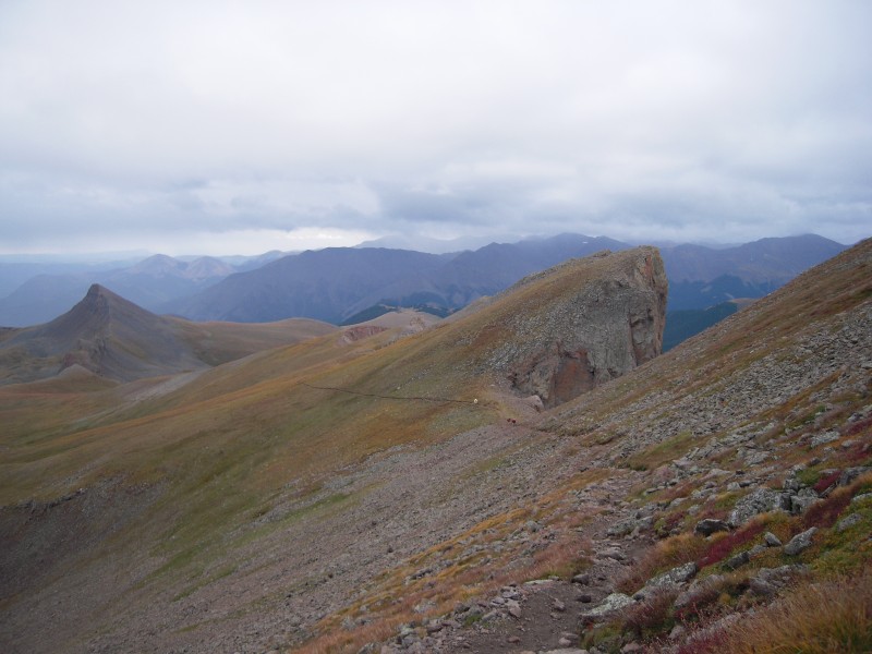 This is where a little more prep work would have paid off. At the top of the switchbacks, low clouds enveloped us as we made our way to the crux. I had originally planned to climb Shavano/Tabegauche this weekend and studied that route front and back, but with a late change of plans Uncompahgre was now the intended peak. I did a quick route recce and read some TRs, but missed the gotcha on the crux. When coming up to the base of the second tier of Uncompahgre, you are greeted with several steep slopes with loose rock. Bill (and others) recommend going left (north) of the needle like rock at the base  to us, the route looked more obvious to the right of the needle. Not a huge deal, we were capable, but the weather was getting thick, visibility was reduced and I was already worrying about getting my 11 year old pup (Bing) down said slope. Sure she can climb like a champ, but she's a lot less capable on the downclimb. 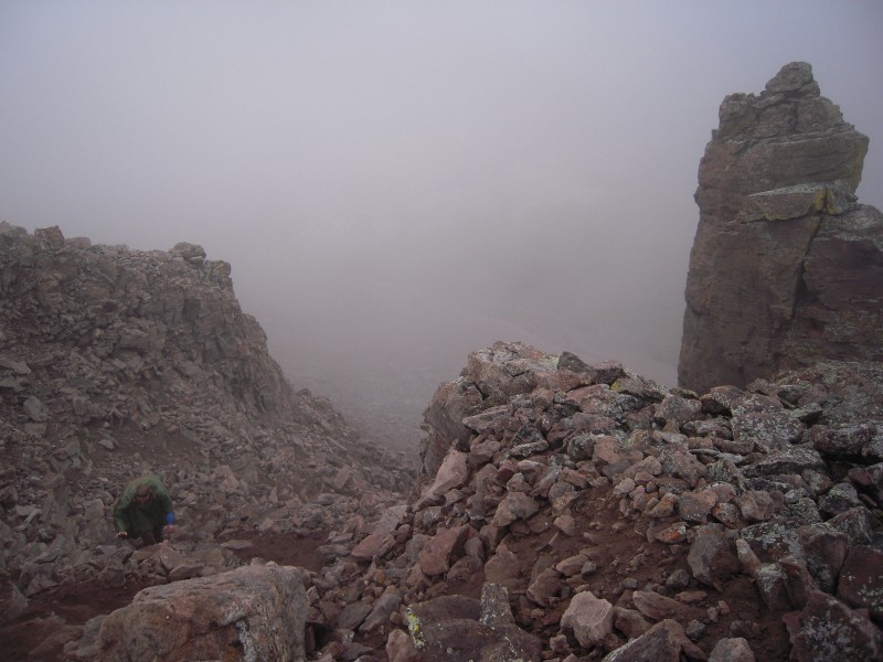 Luckly, when we topped out, we saw the err of our ways and there was a much nicer route to the north of the needle. So with clouds descending, we turned towards the summit. 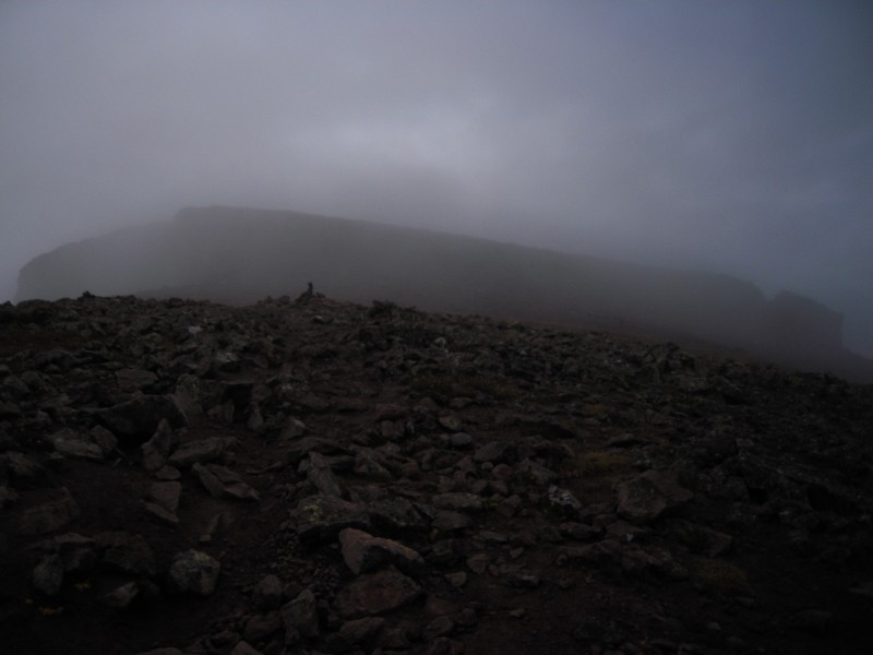 The final push was uneventful except that snow started to fall (graupel, then the fluffy stuff), first snow of the season! We reached the summit about two and a half hours after departing the TH. Uncompahgre's summit was ours alone, climbing in the weather, on a weekday, away from Denver metro has its perks. The great views that one expects from the top, were not there due to the weather, and I have to say that those cliffs are more unnerving when there is nothing below you but a drop and clouds. 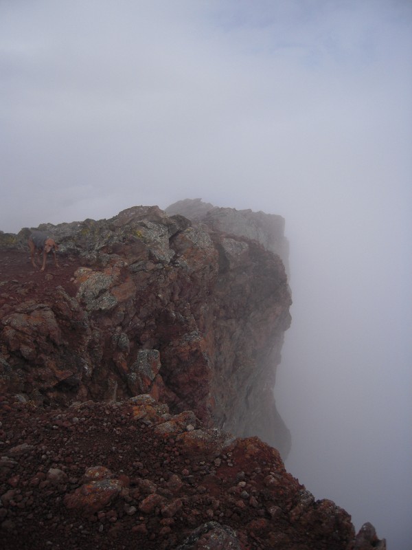  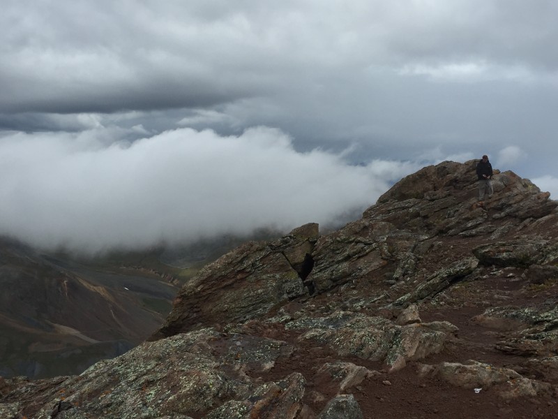 Because of the weather, we kept our stay on the summit brief and the snow had really started to fall as we began our descent. We chose the north side of the needle to get down the crux and while it was easier, there is still a lot of loose rock to keep you on your toes. 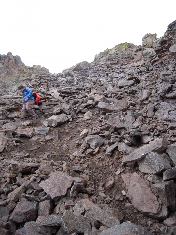 As we got to lower elevations, the snow changed to sleet, and changed to rain and we were awarded wonderful views of the basin below as the clouds rolled through.  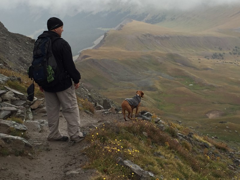 Cold and wet, we eventually reached the TH as the sun popped out from behind the clouds (of course). Even with the less than ideal weather, Uncompahgre Peak has now earned a spot in one of my all time favorite mountains. It's a gorgeous mountain, a great hike and is one that I would climb again in a heartbeat if ever asked to again. A perfect mountain to mark the passing of another year and beginning of another. *End note: The 4WD road up to Nellie Creek TH really was not a big deal for my stock 4wd and there was a smaller stock 4wd (Rav4?) that made it up there too. The only real issue I had was on the descent. After all the rain from the day, the mud was slick, stupid slick, slick to the point where some brief moments it was more of an uncontrolled slide downhill than a controlled drive down. **End note 2: If you decide to drive to Ouray from Uncompahgre, over Engineer Pass, make sure you have a non-stock SUV. Something lifted or Jeep like. Whatever you do, don't go in there with the mind set that say, your parents drove it in their stock Isuzu Rodeo therefore your 4Runner should be just fine. First off this premise is probably wrong. Your parents probably went over the pass and then turned up Cinnamon Pass instead of continuing down towards Ouray. Secondly it gets a lot worse on the Ouray side of the descent. A lot worse. I don't have any pictures as I was white knuckled on the steering wheel and the pucker factor was not allowing me out of my seat. When you have the honest discussion of "well do we go over that transmission gouging rock or off the 500' cliff", you may be a little out of sorts. The end state, and I really am shocked at this, was one streamlined tailpipe. Running boards, fuel tank, transmission, and skid plate should all be missing...Toyota may be getting a thank you letter from me. Thumbnails for uploaded photos (click to open slideshow):
|
| Comments or Questions | ||||||
|---|---|---|---|---|---|---|
|
Caution: The information contained in this report may not be accurate and should not be the only resource used in preparation for your climb. Failure to have the necessary experience, physical conditioning, supplies or equipment can result in injury or death. 14ers.com and the author(s) of this report provide no warranties, either express or implied, that the information provided is accurate or reliable. By using the information provided, you agree to indemnify and hold harmless 14ers.com and the report author(s) with respect to any claims and demands against them, including any attorney fees and expenses. Please read the 14ers.com Safety and Disclaimer pages for more information.
Please respect private property: 14ers.com supports the rights of private landowners to determine how and by whom their land will be used. In Colorado, it is your responsibility to determine if land is private and to obtain the appropriate permission before entering the property.


