Download Agreement, Release, and Acknowledgement of Risk:
You (the person requesting this file download) fully understand mountain climbing ("Activity") involves risks and dangers of serious bodily injury, including permanent disability, paralysis, and death ("Risks") and you fully accept and assume all such risks and all responsibility for losses, costs, and damages you incur as a result of your participation in this Activity.
You acknowledge that information in the file you have chosen to download may not be accurate and may contain errors. You agree to assume all risks when using this information and agree to release and discharge 14ers.com, 14ers Inc. and the author(s) of such information (collectively, the "Released Parties").
You hereby discharge the Released Parties from all damages, actions, claims and liabilities of any nature, specifically including, but not limited to, damages, actions, claims and liabilities arising from or related to the negligence of the Released Parties. You further agree to indemnify, hold harmless and defend 14ers.com, 14ers Inc. and each of the other Released Parties from and against any loss, damage, liability and expense, including costs and attorney fees, incurred by 14ers.com, 14ers Inc. or any of the other Released Parties as a result of you using information provided on the 14ers.com or 14ers Inc. websites.
You have read this agreement, fully understand its terms and intend it to be a complete and unconditional release of all liability to the greatest extent allowed by law and agree that if any portion of this agreement is held to be invalid the balance, notwithstanding, shall continue in full force and effect.
By clicking "OK" you agree to these terms. If you DO NOT agree, click "Cancel"...
The Knife Ridge traverse between West Babcock Peak to Spiller Peak in La Plata Canyon, near Hesperus, CO.
Mileage: Around 8 miles roundtrip with our circuitous routes on the way up and down.
Elevation Gain: 4200' give or take a little
Ever since I bought Dave Cooper's Colorado Scrambles book a few years ago this scramble has been on my to-do list. Last year friends and I tried to do this route 3-times. The first time we ran into too much snow in late May. The second time mother nature decided to have a moment and shot lightning bolts at us while we were a mile from tree line and running for our lives. The third time Ross and I decided to summit Middle Babcock (the highest of the 4 peaks of Babcock) and the weather wasn't looking so good to try and commit to the ridge traverse.
Fast forward to this year and a bluebird Saturday in late July. I had just purchased a GoPro Hero4 and knew exactly what route I wanted to hike to pop its cherry. I picked up Ross (FlatLander89) in Durango around 6:30 and we headed to La Plata Canyon.
Once you reach the entrance to the canyon, the dirt road to the Boren Creek 4x4 road is 2wd accessible. Not too far past this though and the road starts getting pretty boney and not fun in a sedan. But for this hike, a 2wd car is fine to get to the bottom of the 4x4 road.
It's about 3-miles up the road with numerous switchbacks until you reach tree line. Staring you in the face is the knife ridge.
Looking up at the knife ridge. Babcock peaks on the right, Spiller on the left just after that huge notch in the ridge.
The 4x4 road ends at this point and you now get the pleasure of talus/boulder hopping up towards the Babcock peaks. It's somewhat steep and the boulders like to keep you focused by moving every now again. So Dave Cooper's route description tells you to head towards the left most couloir (like you would if you were going to summit middle Babcock) and once you get to the top of the couloir there's some class 3 scrambling to the peak of West Babcock. However, we decided that we wanted to gain West Babcock via its face, to the left of that narrow pencil couloir in the picture below. I read a blog post on the interweb about this route and it sounded like more scrambling and less boulder hopping. Sign me up!
About halfway up the boulder field, looking at West Babcock (center).
It was a breath of fresh air to make it off of that boulder field and onto the face of the mountain. This is where the fun began.
You can see Ross leading the way, heading towards the chimney feature.
We headed up through what we referred to as the chimney to gain the face of West Babcock. The scrambling up through the chimney had some loose rock and dirt that made things a little more exciting.
Ross making his way up through the chimney area.
From here it was up to West Babcock and the knife ridge! I'd say it was mainly class 2 and 3 scrambling. The rock was somewhat solid. But knocking down football sized rocks by accident was easier than you'd like. Bring your helmet and stagger your routes up this face to avoid any rock sammiches to your face.
Looking up towards the knife ridge. Fun class 3 scrambling and somewhat solid rock.
Looking south towards the entrance to La Plata Canyon. Ross making his way up the mountain.
And with a little more effort we made it to the ridge. Unfortunately we had veered off a little too far to the northwest and missed West Babcock's peak by a bit. But we weren't really there for that peak. We were there for the knife baby!!!
Looking over towards Spiller Peak, our destination.
Looking back at West Babcock.
The ridge started off pretty tame (from what I was expecting. It's all relative I suppose). We basically stayed on the top of the ridge most of the time, only straying to either side of the ridge a few feet at most when needed. The closer to Spiller we got, the spicier the exposure became. The rock was hit or miss. Some rocks that looked solid pulled away from the mountain with such ease you'd think they wanted nothing to do with the ridge. While other rocks that looked rotten as hell were the most solid holds of the day. Weird. Anyways, definitely check every hand hold and foot placement before putting your weight entirely on it.
Ross making his way across the ridge. Spiller Peak in the background.
It took us about an hour to traverse to the notch below Spiller Peak. The last 40 feet of the ridge to the notch were probably the most exposed scrambling I've ever done. I made a 7-minute GoPro video of this section if you wanna check it out at the end of this trip report.
Looking North from left to right: Hesperus Mountain, Lavender Peak, Mt. Moss
Ross looking back at me as I was about to make my way through the most exposed portion of the ridge.
Looking back from where Ross was standing.
Looking back at the ridge from the Notch.
Once we made it to the notch between the knife ridge and Spiller we had to find our way down the ridge side of the notch and back up the Spiller side of the notch. Going down the notch between Spiller and the ridge is a loose chossy mess. Rather than following Cooper's route further down the loose crap gulley we decided to make a more direct approach up Spiller. I've never done class 4 scrambling but this sure felt a little more than the class 3. You be the judge. In the video, this section shows up around the 4:25 mark. I've got no real rock climbing experience so my hand, foot and knee placements were probably not the most advantageous.
Ross making his way up the Spiller side of the notch.
Another shot of Ross climbing up the last tricky section.
Once we got over that tricky section it we had 15 minutes of class 3 scrambling and we made it to the top of Spiller Peak. It was a beautiful day for an exposed scramble!
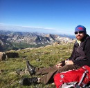
Panorama from Spiller Peak.
After fueling up on some candy we started our descent down Spiller Peak. Here's a view looking back at the knife ridge from the southwest ridge Spiller.
The view of the knife ridge from the southwest ridge of Spiller Peak. Saweet!
You can choose your route back down to the 4x4 Boren Creek road. If you want to bag another peak, keep heading down the ridge from Spiller over to Burwell Peak. Ross made his way over there, but I had a moment where I lost all testicular fortitude and turned back at this really exposed mini knife ridge. I must've used up all my adrenaline or thought about it for too long, but didn't feel like going over this last bit. So I turned around and went down some hellish talus instead.
The exposed ridge that led to Burwell Peak. Ross making a kinda sketchy move up off of the ridge. Pictures really don't d
A straight on look at the mini ridge.
The nicest thing about hiking in the La Platas is the lack of people there. Ross and I saw no one all day. During the dozens of hikes I've done up there over the last 3 years, I've only seen probably 10 people in total. So if you're in Durango area and want to get away from the crowds and want a fun scramble, give this one a try.
As promised, here is the GoPro video showing some of the more exposed sections on the knife ridge. Enjoy!
Thumbnails for uploaded photos (click to open slideshow):
Did this 6 or so years ago, but from the other direction. Definitely a really cool hike, and if you’re up there it is worth going up Burwell Peak too. Love that area.
With a title like that, I expected Wu–Tang references throughout the body of the report. I mean just off the top of my head you could’ve said that route "ain’t nothin to F*** with" or that Cairns Rule Everything Around Me.
No people, fun scrambles, sweet peaks, solid weather – can’t ask for much more. One of these days I’ll dedicate a long weekend to that group. It just needs to happen.
And I know what you mean about losing all testicular fortitude. It happens. They should name that knife edge "The Overlook Hotel". Solid TR.
@MaxKugel – nice! we were considering doing it from Spiller over to West Babcock but the thought of boulder hopping down the side of Babcock made us decide to go up it instead.
@dannyg23 – damn it, I totally screwed my trip report up didn’t I? The pun game is not strong with this one. Bring the mother rocking talus, bring the mother rocking talus! I’ll work on it!
@lordhelmut – Thanks! It was a perfect day in the mountains, no doubt. You can definitely hit up multiple peaks in the Boren Creek and Tomahawk Basins (right next to each other) in a day or two.
Caution: The information contained in this report may not be accurate and should not be the only resource used in preparation for your climb. Failure to have the necessary experience, physical conditioning, supplies or equipment can result in injury or death. 14ers.com and the author(s) of this report provide no warranties, either express or implied, that the information provided is accurate or reliable. By using the information provided, you agree to indemnify and hold harmless 14ers.com and the report author(s) with respect to any claims and demands against them, including any attorney fees and expenses. Please read the 14ers.com Safety and Disclaimer pages for more information.
Please respect private property: 14ers.com supports the rights of private landowners to determine how and by whom their land will be used. In Colorado, it is your responsibility to determine if land is private and to obtain the appropriate permission before entering the property.


 Looking up at the knife ridge. Babcock peaks on the right, Spiller on the left just after that huge notch in the ridge.")
 About halfway up the boulder field, looking at West Babcock (center).")
 You can see Ross leading the way, heading towards the chimney feature.")
 Ross making his way up through the chimney area.")
 Looking up towards the knife ridge. Fun class 3 scrambling and somewhat solid rock.")
 Looking south towards the entrance to La Plata Canyon. Ross making his way up the mountain.")
 Looking over towards Spiller Peak, our destination.")
 Looking back at West Babcock.")
 Ross making his way across the ridge. Spiller Peak in the background.")
 Looking North from left to right: Hesperus Mountain, Lavender Peak, Mt. Moss")
 Ross looking back at me as I was about to make my way through the most exposed portion of the ridge.")
 Looking back from where Ross was standing.")
 Looking back at the ridge from the Notch.")
 Ross making his way up the Spiller side of the notch.")
 Another shot of Ross climbing up the last tricky section.")
 Panorama from Spiller Peak.")
 The view of the knife ridge from the southwest ridge of Spiller Peak. Saweet!")
 The exposed ridge that led to Burwell Peak. Ross making a kinda sketchy move up off of the ridge. Pictures really don't d")
 A straight on look at the mini ridge.")