Download Agreement, Release, and Acknowledgement of Risk:
You (the person requesting this file download) fully understand mountain climbing ("Activity") involves risks and dangers of serious bodily injury, including permanent disability, paralysis, and death ("Risks") and you fully accept and assume all such risks and all responsibility for losses, costs, and damages you incur as a result of your participation in this Activity.
You acknowledge that information in the file you have chosen to download may not be accurate and may contain errors. You agree to assume all risks when using this information and agree to release and discharge 14ers.com, 14ers Inc. and the author(s) of such information (collectively, the "Released Parties").
You hereby discharge the Released Parties from all damages, actions, claims and liabilities of any nature, specifically including, but not limited to, damages, actions, claims and liabilities arising from or related to the negligence of the Released Parties. You further agree to indemnify, hold harmless and defend 14ers.com, 14ers Inc. and each of the other Released Parties from and against any loss, damage, liability and expense, including costs and attorney fees, incurred by 14ers.com, 14ers Inc. or any of the other Released Parties as a result of you using information provided on the 14ers.com or 14ers Inc. websites.
You have read this agreement, fully understand its terms and intend it to be a complete and unconditional release of all liability to the greatest extent allowed by law and agree that if any portion of this agreement is held to be invalid the balance, notwithstanding, shall continue in full force and effect.
By clicking "OK" you agree to these terms. If you DO NOT agree, click "Cancel"...
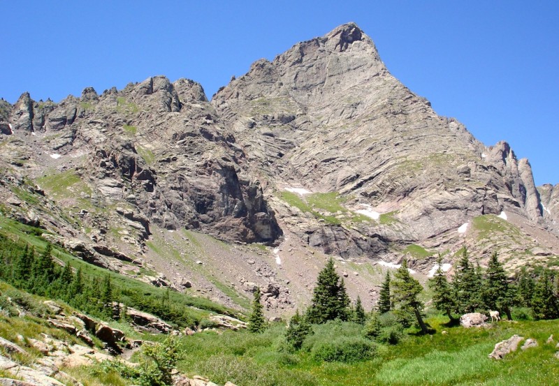
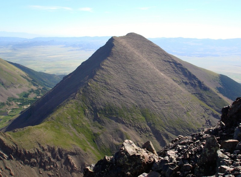
Finally, Threading the Needle! The beautiful Crestone Needle
Crestone Needle (14,197')
July 28, 2015
Trailhead: South Colony Lakes
RT Distance: 13.5 miles
Elevation Gain: ~5100'
Climbers: gorshkov (Grant) and MtnHub (Doug)
Introduction:
Many climbers have a peak that becomes a nemesis for them, a peak that has given them trouble even on several different attempts. Mine has been the Crestone Needle. I've been trying to bag this peak for over 4 years. The online route has always intrigued me plus so many other climbers list it as their favorite peak. Consequently, I've wanted to experience this one badly for quite some time. But either poor weather or last-minute partner bailouts have plagued my attempts thus far.
As I did not want to do an overnight camping trip, I was limited to finding partners willing to attempt it as a long day hike. To cut the mileage down a bit, I also needed someone who had a 4WD vehicle to get us to the upper TH. This year things looked very optimistic. I found two people interested in attempting it with me, one of which had a 4WD Jeep.
The Climb:
My watch alarm goes off at 0100 in my room at the Westcliffe Inn. I slept better than I anticipated, and I know I got much better rest than had I been camping. I heard Jeff drive up about an hour ago so I know he made it from Denver as planned. He was to meet me here and then drive us both to the lower TH where Grant would be car camping.
When I go outside with all my gear, we introduce ourselves to each other. Jeff seems a little preoccupied and nervous and when we are finally in his car together, he mentions that he has not been feeling quite up to par and has not been sleeping well the last couple of nights. The thought of yet another year of disappointment pops into my head, but then Jeff tells me he is still willing to drive us to the upper TH and then evaluate how he feels. If he still doesn't feel quite right, he will head home and let Grant and me continue the climb together. But we would still have to walk back down the extra 3 miles to the lower parking after a summit. This is OK with me and I'm hoping Grant will agree to it as well.
Grant is waiting outside of his pickup as we pull into the lower parking area. Once again, we all introduce ourselves to each other and then load up into Jeff's vehicle. As he starts driving up the initial portion of the road, he tells Grant he is thinking of bailing because he feels out of sorts and not truly up for the climb. Grant and I both assure him that may be the best thing. You certainly don't want to push yourself through such a long and grueling climb. You need to listen to your own body and act accordingly.
This road really freaks me out. I can't believe people actually drive on these conditions traversing over these crater-like potholes and huge rocks and boulders, and I would always choose to walk a few extra miles rather than risk some damage to my vehicle. But Jeff takes it quite well. When we reach the really bad spot in the road about halfway up, he does pause to take a closer look. He tells us he was up this way earlier this year when he climbed Humboldt, but all the recent rains must have eroded the road a little more. It looks simply horrendous to me!
He makes a few unsuccessful attempts to get past the roughest stuff. Grant and I get out to look it over better and provide some more on-the-spot assistance. Jeff makes one more futile attempt but when he hears a thunk and starts smelling oil and heat, he tells us this will be as far as he goes. Grant helps him turn around, we bid Jeff a safe journey home, and then we start up the road on foot.
Our pace is closely matched and we make great time. By the time we reach the Colony Lakes turnoff it is still pretty dark. We find a sheltered place along the trail about halfway up to the Pass and hunker down for a bit. We want to be able to see better when we reach the snowfield crux just above us. Grant nearing the snowfield crux.
When the pre-dawn light provides enough clarity, we load up again and continue on the trail. All the recent condition reports suggest the snowfield can be avoided by staying off to the side on solid rock. I am certainly hoping this is true. Although I've used an ice axe and crampons once before, I really don't feel comfortable on ice and will do most anything to avoid it if at all possible.
We reach the base of the snow and we can see a well-defined series of steps cut into the ice right up through its center. But the angle of the slope is much steeper than I like. However, looking to the side, the rock also looks pretty steep and cliffy to climb. We debate our options. Grant only has micro-spikes along and no axe and therefore tells me he will opt for the rock. I don't like the looks of them however, and since I have both axe and crampons, I reluctantly choose to don them and go slowly up the snowfield.
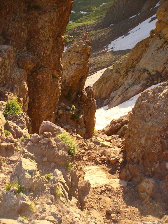
Because of my extra traction and even though I ascend very deliberately and cautiously, I reach the top of the snowfield before Grant does. So, removing the crampons and re-attaching the axe to my pack, I wait on a ledge until Grant can rejoin me. Just above the ice.
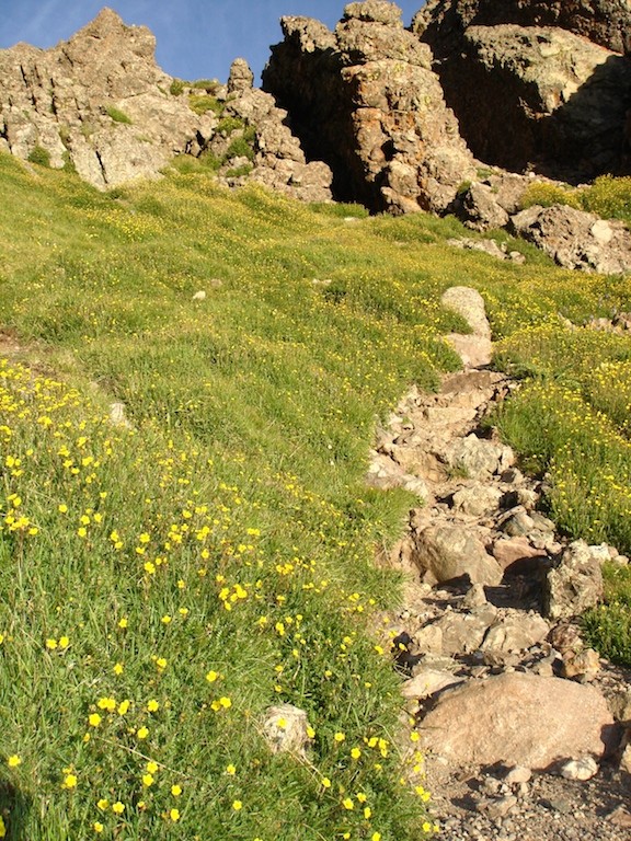
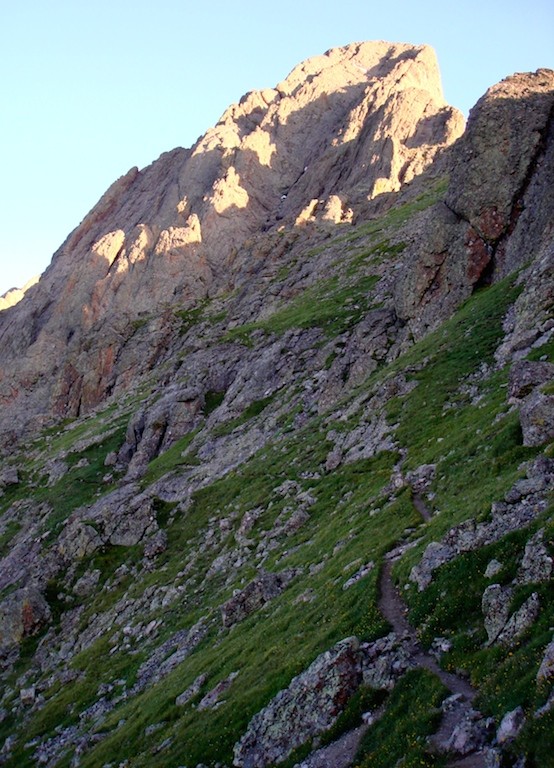
The rest of the way up to Broken Hand Pass is very steep, but at least it's on regular trail again. Above the crux, the trail leading to Broken Hand Pass.
We take a short break to refuel and hydrate at the saddle. A quick rest at the Pass.
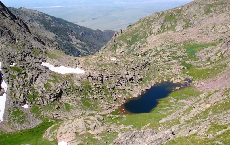
Now on the west side of Broken Hand, we are in the shadows and sheltered from the sun. The Cottonwood Creek basin is lovely to view. I've heard from many reports that although it has a slightly longer approach, it is a gorgeous route to tackle these mountains. Cottonwood Lake in the shadows.
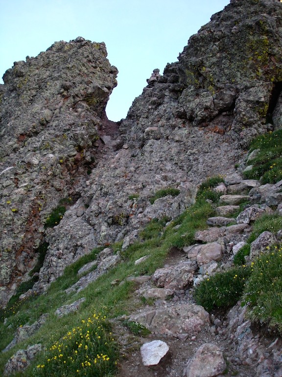
As we look ahead, the trail leads us up and through a notch. Cross through this notch.
Once we pass through it, the South Face comes into view. We will be climbing on the famous knobby rock very soon! The trail leading to the South Face of Crestone Needle.
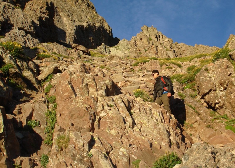
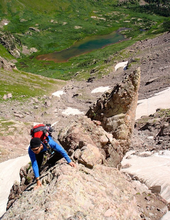
When we come up to the Face, we search for the correct gully to climb. For whatever reason, neither of us see what we are expecting to find. We climb up one gully only to climb down again thinking it is the incorrect one. Even when we finally reach the Dihedral, it just doesn't look like what we remember seeing on Bill's route pictures. The rock slopes are very steep, but at least it is knobby enough for us to maneuver well on. Climbing up the knobby rock.
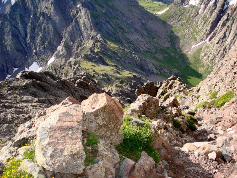
Looking down the trail towards Broken Hand Pass.
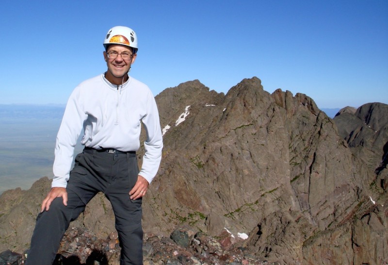
Eventually we recognize some major landmarks and are assured we are on track. We hit the summit just before 9am, finally threading the elusive Needle. My summit shot, happy to have this one under my belt.
Crestone Peak
Humboldt Peak
Our descent goes easier but we still have a little trouble at the Dihedral crossing, climbing up and down in a few places before finding a safe passage across. But the main thing on my mind now is the snowfield. I'm not looking forward to having to down climb on the sun-softened snow. It is too steep to assume a safe glissade and I'm not sure the crampons will be much help anymore. Cottonwood Lake again, in full sunlight.
We both opt to downclimb on the rocks rather than even consider the snow. Grant leads and has a little trouble reaching a foothold in one place. He makes it down and then spots me a couple of times to drop safely. I'm guessing a few of those moves were extreme C4, if not a low C5, a little more sketchy than I'm really comfortable with. It's good to have a competent partner along! Down-climbing the C4-5 stuff to the side of the snowfield.
The rest of the hike out is uneventful but very tiring. The trail is quite rocky and uneven and doesn't offer much relief for the knees and feet. We meet several goats just below the Lake surveying the now empty campsites searching for dropped or leftover food scraps. I was hoping to catch one in a photo, but every time I got my camera out, they moved on to somewhere new. South Colony Lakes
When we reach the upper parking lot, a father and young son are just loading up their large pickup after enjoying a camping/fishing trip at the Lake. They are obviously heading back into town. Grant inquires if we could possibly hitch a ride with them down to the lower TH and they agree. This is very fortunate as being a weekday, there are not a lot of other campers/climbers on the trail.
Grant drives me back to the motel thus culminating a wonderful day. The beautiful Crestone Needle
Thumbnails for uploaded photos (click to open slideshow):
Yes, the mountains all over seemed especially lush and green this year. The late heavy snows probably had something to do with it. Thanks for your comment!
All the stars lined up for you this time on this summit. Glad you got that one under your belt! Hope your friend didn’t end up with a hole in the oil pan!
Thanks so much for the Great report Doug! Congrats on finally bagging it! I’m hoping to do the same this weekend. Would be curious what time you reached the upper trailhead on your return (roundtrip time). I’d heard that the 4WD road had some maintenance done to it in early August and would be curious if anyone can confirm. I drive a little Rav4 and am not sure I’d want to attempt it after reading about Jeff’s truck...
Our round trip time is difficult to truly estimate, as first off, we hunkered down below the Pass for a good 15–20 minutes until it got light enough for us to see well enough to continue up to Broken Hand. I would guess (and that’s all it really is) we left the upper TH between 3:30–4:30 as it was pretty dark at that time. We got back to the upper TH about 1:30pm I believe when we caught the ride down to the lower one. Hope that helps you a little. Good luck on a fun peak!
Caution: The information contained in this report may not be accurate and should not be the only resource used in preparation for your climb. Failure to have the necessary experience, physical conditioning, supplies or equipment can result in injury or death. 14ers.com and the author(s) of this report provide no warranties, either express or implied, that the information provided is accurate or reliable. By using the information provided, you agree to indemnify and hold harmless 14ers.com and the report author(s) with respect to any claims and demands against them, including any attorney fees and expenses. Please read the 14ers.com Safety and Disclaimer pages for more information.
Please respect private property: 14ers.com supports the rights of private landowners to determine how and by whom their land will be used. In Colorado, it is your responsibility to determine if land is private and to obtain the appropriate permission before entering the property.