Download Agreement, Release, and Acknowledgement of Risk:
You (the person requesting this file download) fully understand mountain climbing ("Activity") involves risks and dangers of serious bodily injury, including permanent disability, paralysis, and death ("Risks") and you fully accept and assume all such risks and all responsibility for losses, costs, and damages you incur as a result of your participation in this Activity.
You acknowledge that information in the file you have chosen to download may not be accurate and may contain errors. You agree to assume all risks when using this information and agree to release and discharge 14ers.com, 14ers Inc. and the author(s) of such information (collectively, the "Released Parties").
You hereby discharge the Released Parties from all damages, actions, claims and liabilities of any nature, specifically including, but not limited to, damages, actions, claims and liabilities arising from or related to the negligence of the Released Parties. You further agree to indemnify, hold harmless and defend 14ers.com, 14ers Inc. and each of the other Released Parties from and against any loss, damage, liability and expense, including costs and attorney fees, incurred by 14ers.com, 14ers Inc. or any of the other Released Parties as a result of you using information provided on the 14ers.com or 14ers Inc. websites.
You have read this agreement, fully understand its terms and intend it to be a complete and unconditional release of all liability to the greatest extent allowed by law and agree that if any portion of this agreement is held to be invalid the balance, notwithstanding, shall continue in full force and effect.
By clicking "OK" you agree to these terms. If you DO NOT agree, click "Cancel"...
Matterhorn Creek (lower) Trailhead: 3:36am Wetterhorn Summit: 6:06am Matterhorn Summit: 8:03am Uncompahgre Summit: 10:26am Back to Lower TH: 1:20pm Distance: 15.9 miles Elevation gain: 7,500'
My son and I had been thinking about climbing Wetterhorn for a year now and after reading the trip reports, looking at photos and videos of the crux of the route, we were a bit nervous. We finally got up our courage and decided we would do this together. Since he hadn't climbed Uncompahgre, we looked at our options for getting both on the same trip. Originally, we thought combining Wetterhorn and Matterhorn in the first day from Matterhorn Creek and climbing Uncompahgre from Nellie Creek would be a good way to combine the two in the same trip. Reading about the Nellie Creek 4wd road, we thought better of taking my wife's Pilot to the upper TH and didn't want to add 8 miles of road to the day 2 hike. So, we looked at some great trip reports to set our plan for doing the whole circuit from Matterhorn Creek.
We decided to climb Wetterhorn first since we didn't want to face the fear crux of that route with rubbery legs. To reduce the weather risk, we wanted to start very early. With our expected pace, we thought a 3:30am start would put us on the crux of Wetterhorn with enough light and set the alarm for 3:00. After fumbling around, we were off only a few minutes behind schedule.
The stars were spectacular and we caught the tail end of the Perseus meteor shower on the way up. We made great time and had to consciously slow down to wait for the light. Following the trail was initially easy but was more difficult passing through some of the boulder fields in the dark. The yellow dirt slope looked white with our headlamps and was very slick going up and down. At the base of the scrambling section, it was just light enough to take off the headlamps and put on our helmets and begin the fun part. The climb to the V-notch and up the second gully was a good warm-up for the crux and the timing worked out great with the light. For all of our worries, the final pitch was fun and not at all difficult. The experience we've gained since both of us seized up our first time at the Narrows on Longs Peak put those fears to rest and there was no hesitation for either of us. Before we knew it we were on top watching the sun rise over Uncompahgre. This was my 39th and Nick's 32nd 14er.
What a place to see the sun rise!
We didn't linger too long knowing we had a long way to go so we started down, snapping some photos.
Aw shucks, this isn't so bad...
This is fun!
Nick coming down
Nick almost to the base
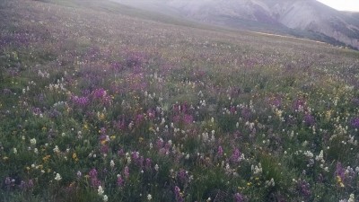
We ran into a few folks as we descended the gully before the yellow dirt and a few more before we split from the trail and headed across the basin to Matterhorn's steep grassy south slope. The wildflowers were out of this world! Unfortunately, the sun still hadn't risen to fully capture it with our limited photographic skills.
Wildflowers everywhere
More wildflowers
Once above the ridge and on Matterhorn's grassy south slope, we set a (slow) pace that we could sustain. I think this was the steepest part of the full circuit. We reached the beginning of the scrambling section and took a minute to look at the trail description and started climbing the large, mostly stable, boulders. It was fun and, before we knew it, we were on top. On the small summit, we grabbed a quick snack and heard some weird noises. We looked down to see a herd of domestic sheep grazing in the basin between Matterhorn and Uncompahgre. Later, they had moved to Wetternorn's east slopes when we came through on our way down.
From Matterhorn's summit our first view of the herd of sheep
Again, we didn't linger too long before starting back down. We reached the grassy slope and set our target in the basin. There are few obstacles on the south and southeast side of Matterhorn so it's really up to you what path to take. The topography in the basin drops considerably to the north so we aimed to reach the stock trail above the first significant slope break.
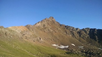
After reaching the trail, we started to look at our options for climbing Uncompahgre. There are three basic options. Our initial plan was to ascend a wide gully coming off Uncompahgre's south ridge and connecting with the standard route (labeled 1). We considered climbing directly up Uncompahgre's west slopes to connect with the standard route at its crux (labeled 2). Last, we could follow the stock trail all the way around the south ridge to connect with the standard route south of the cliffs entirely (labeled 3). There are trip reports on the first and third option with GPS tracks. Here's a picture of Uncompahgre on our way back with the three options labeled.
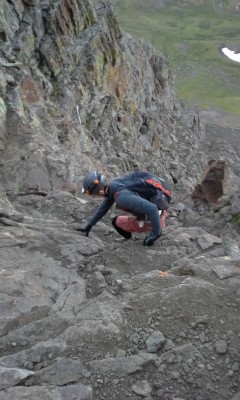
We couldn't decide between option 1 and 2 from a distance because the sun was still casting shadows on both from where we were in the basin but we didn't want to add the extra mileage by going all the way around the ridge. So, we decided to ascend the grassy slope and take a look at the west slopes and decide either to do that or traverse above the cliffs to our planned route up the wide gully. The upper part of the west slopes (option 2) didn't look too bad from below but there was a cliff band at the base of that route that we couldn't see very well so we decided to bypass that and go to the gully we originally planned to climb (option 1). In retrospect, I wish we had gone up a little further and looked at the cliff bands on option 2 more closely. We wouldn't have had to go up much further to take a look. The gully we ascended was not very nice. Initially, the slope was white soft flour with a few larger rocks laid on top. The slope was basically at the angle of repose for this soil and it moved when you tried to step on it. I had trekking poles which helped with balance and to spread my weight; Nick did not. We traversed to climber's right to some larger boulders which were marginally more stable and ascended. dehrlich01 posted a trip report for this route but they descended this gully a little more directly than we ascended so they probably didn't enjoy the white flour soil as much as we did. Here's a picture as we traversed to the gully along the top of the cliffs.
Getting ready to climb Uncompahgre's gully
After we reached the top of the gully, we took off our boots and dumped the gravel that had built up and made our way quickly to the summit. It had been 2005 when I first climbed Uncompahgre and it was just as enjoyable the second time with out of this world views of the San Juans. The crux was short and sweet and not too different from Wetterhorn's crux (a little shorter, more loose rock, not quite as steep). This made 33 for Nick (as with most things, he's likely to pass me soon).
One tired old guy and one great hiking partner
Looking west from Uncompahgre - Wetterhorn, Matterhorn, Coxcomb, Sneffels, Wilson group
Now, for the long trip back. Nick and I talked about going down the west slope of Uncompahgre but we still didn't know what the cliff band would be like and it was at the bottom of the route. We decided to bypass the ridge and loop all the way around the south ridge. It would add a few miles but we figured it would be much faster than figuring out the cliffs on the west slopes or dealing with that nasty gully that we came up. It turned out very nice and gave us plenty of opportunities to take some pictures looking west at what we had done. The trek through the basin was long and, though the slope up wasn't that great, was a real challenge for our rubbery legs (at least mine) that had already taken us up over 7,000' since we started.
Matterhorn with Wetterhorn lurking Wetterhorn from the final ascent of the day to the pass - definitely thumbs up! Nick grabbing a bite at the pass Wetterhorn with herd of sheep Are we to the car yet?
We arrived back at the car at 1:20pm for just under 9 hrs 45 minutes total.
This was an enjoyable hike and the basin between Wetterhorn and Matterhorn is beautiful. The flowers are incredible right now! Aside from Uncompahgre, I was surprised at how few people we saw. We were out early but even on the return we only saw a half dozen people once we left Uncompahgre's trail.
My GPS Tracks on Google Maps (made from a .GPX file upload):
Glad you had a great time with your son. That was very well done and good pictures. I hope to do Wetterhorn for the first time when I am in Lake City next week.
Congrats on getting all 3... and a great trip report! My partner (Bryan) and I were the 2 people you met in the gully on your descent. We had the summit all to ourselves and took the alternate path down that you recommended (to the left on the downclimb). We thought we might see you on our way up Matterhorn, but you must have been much faster than us! And I agree, the stars were amazing that morning!
Happy you had a good day too. That basin between Wetterhorn and Matterhorn is somthing!
Caution: The information contained in this report may not be accurate and should not be the only resource used in preparation for your climb. Failure to have the necessary experience, physical conditioning, supplies or equipment can result in injury or death. 14ers.com and the author(s) of this report provide no warranties, either express or implied, that the information provided is accurate or reliable. By using the information provided, you agree to indemnify and hold harmless 14ers.com and the report author(s) with respect to any claims and demands against them, including any attorney fees and expenses. Please read the 14ers.com Safety and Disclaimer pages for more information.
Please respect private property: 14ers.com supports the rights of private landowners to determine how and by whom their land will be used. In Colorado, it is your responsibility to determine if land is private and to obtain the appropriate permission before entering the property.


 This is fun!")
 From Uncompahgre, Wetterhorn (Nick's 33rd) in the background")
 Wetterhorn with herd of sheep")
 Matterhorn with Wetterhorn lurking")
 Uncompahgre from the basin")
 Wildflowers everywhere")
 Are we to the car yet?")
 Getting ready to climb Uncompahgre's gully")
 Aw shucks, this isn't so bad...")
 Nick coming down")
 Nick almost to the base")
 What a place to see the sun rise!")
 More wildflowers")
 From Matterhorn's summit our first view of the herd of sheep")
 One tired old guy and one great hiking partner")
 Nick grabbing a bite at the pass")
 Wetterhorn from the final ascent of the day to the pass - definitely thumbs up!")
")
 Looking west from Uncompahgre - Wetterhorn, Matterhorn, Coxcomb, Sneffels, Wilson group")