Download Agreement, Release, and Acknowledgement of Risk:
You (the person requesting this file download) fully understand mountain climbing ("Activity") involves risks and dangers of serious bodily injury, including permanent disability, paralysis, and death ("Risks") and you fully accept and assume all such risks and all responsibility for losses, costs, and damages you incur as a result of your participation in this Activity.
You acknowledge that information in the file you have chosen to download may not be accurate and may contain errors. You agree to assume all risks when using this information and agree to release and discharge 14ers.com, 14ers Inc. and the author(s) of such information (collectively, the "Released Parties").
You hereby discharge the Released Parties from all damages, actions, claims and liabilities of any nature, specifically including, but not limited to, damages, actions, claims and liabilities arising from or related to the negligence of the Released Parties. You further agree to indemnify, hold harmless and defend 14ers.com, 14ers Inc. and each of the other Released Parties from and against any loss, damage, liability and expense, including costs and attorney fees, incurred by 14ers.com, 14ers Inc. or any of the other Released Parties as a result of you using information provided on the 14ers.com or 14ers Inc. websites.
You have read this agreement, fully understand its terms and intend it to be a complete and unconditional release of all liability to the greatest extent allowed by law and agree that if any portion of this agreement is held to be invalid the balance, notwithstanding, shall continue in full force and effect.
By clicking "OK" you agree to these terms. If you DO NOT agree, click "Cancel"...
Report Type
Full
Peak(s)
Lone Eagle - 11920
Limbo - 12400
Iriquois - 12799
Mount George - 12876
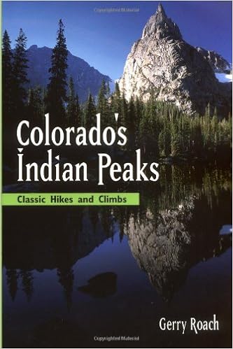
Ever since I dropped $6 on Roach's Indian Peaks book, the cover image of Lone Eagle was practically begging me to climb it. And when I brought up the idea of climbing Lone Eagle to my climbing partner, his wife continued the "walk off"/Zoolander joke we all shared from when we texted her to let her know we were ok and were walking off from the top of a climb in Eldo just as the sun had set. (I'm an ambiturner in case anyone wondered). I then explained Lone Eagle would be a 20 mile "walkoff." But, once Jeff saw some images of Lone Eagle, he too was hooked. Somehow, the ultra massive day of just Lone Eagle morphed into the Mohling Traverse, shorter mileage wise, but a much more difficult day overall.
Traditionally Mohling is Lone Eagle, over Limbo and onto Iriquois. The traditional version is one massive push leaving one to tip their hat to anyone who would even attempt it. Roach says about Lone Eagle alone, "A one-day ascent of Lone Eagle is possible, but this activity is reserved for the extremely fit." So, when a legend like Roach says "difficulty unknown," you know you are in for a big day.
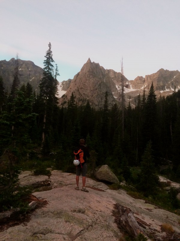
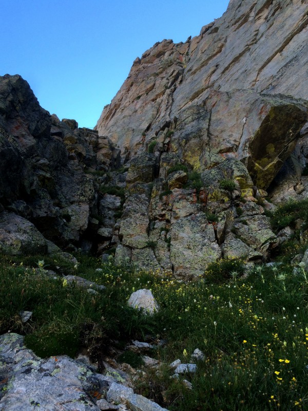
Looking Over Objective #1 for the day
Beta on the Mohling is sparse. A simple google search turns in a handful of trip reports. Perhaps complicating matters is Roach's own route description after giving a brief history of the traverse's namesake, Franz Mohling, and providing a profile picture from the west, "...many of the details are left for those who want to share Franz's adventure. There can be great solace in penetrating the unknown."
Reports peg this day as 17ish miles and 7000'+ of elevation gain from Long Lake. The first 10 miles up and over Pawnee pass to the base of the climb are a cruise, but the business starts when you hit Lone Eagle, as the scrambling and climbing won't relent until you find the trail below Isabelle Glacier. We left Long Lake TH @ 1:45 am and didn't return until 19 hours later.
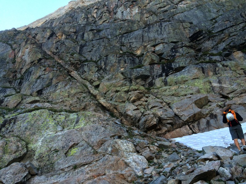
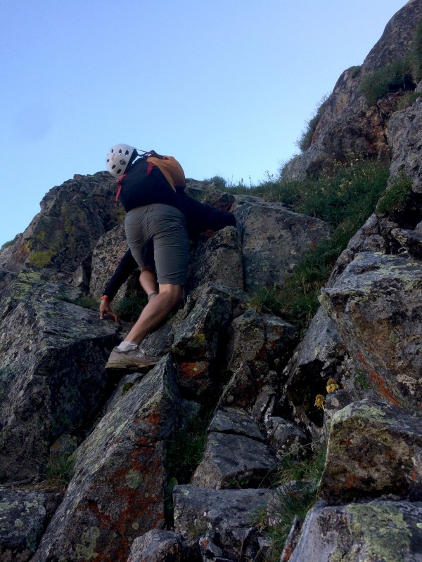
We were 2 hours to the top of Pawnee pass, a good time in my book. But it took us another 2.5 hours to get to Crater Lake where stopped to briefly fill our water and have a quick snack. We then headed west of Lone Eagle and up the talus/scree hell, an excellent harbinger for the rest of the day. We finally found a way up to the upper grassy ledge where the start of the 5.7 "money pitch" is. A team was simul climbing the entire route and we geared up while they passed by. Jeff took the sharp end and headed up.
Ramp from West talus field up to grassy ledge on Lone Eagle
Climbing on Ramp heading up to Lone Eagle's West grassy ledge
The beautiful 5.7 pitch
The 5.7 pitch is amazing. The setting is perfect, the climbing spectacular, and on our day, the weather better than hoped for.
Jeff Leading out the "money pitch"
Once we both had made it up the first pitch, I grabbed the rack and ran up to the right to lead us to the top, following the simul climbing team. Turns out, the normal route goes climber's left, the fist of our many route finding blunders. Right is horrible, wandering and not interesting. I suppose the climbing is better than I am leading on, but when compared to our first pitch that day, it paled in comparison.
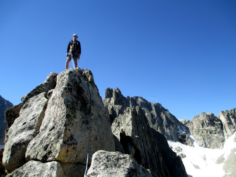
Conor on Lone Eagle summit with Apache in Background
Jeff on Lone Eagle Summit with Limbo in background
By 10:15 am we had stood on top of Lone Eagle, taken some pictures, packed gear and ate some food. The main concern always was weather, so after a quick check to the west we made the decision to push on, knowing that bailing would be ultra crappy and most likely send us back over Pawnee pass - which would suck. The party ahead of us was descending solo flight, the class 4 route on Lone Eagle. When crossing through the col, they accidentally kicked some rock down, so we backed off for a few minutes and gave them some time to work their way down.
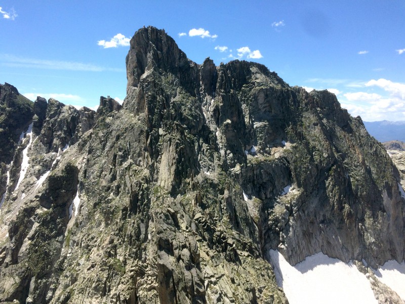
As one crosses the traverse, each objective looks more intimidating than the next. Limbo stared us down and we even discussed skipping it. Curious if we could even regain Iriquois if we bypassed Limbo down low, we decided to go for it. While most trip reports reference crossing over to the west side, we never did seem to find this path. Rather, we gave up a lot of elevation on the east side to eventually take the obvious line straight up to the col. 1 hr and 40 mins after leaving the Lone Eagle summit, we had tagged both sides of Limbo and started to wonder which side of Iriquois to tackle. The gullies look horrible, and the rock to the side of them even worse from a far. While the east side appears to be much more mellow climbing wise, the possibility of getting cliffed out appears to be high and not fun.
Iriquois
With the decisions to push forward and "figure it out as we get closer" made, the next objective was to find the rap down to the Limbo-Iriquois saddle. We did finally cross over the west side of the ridge and stumbled onto the rap. The webbing was in excellent condition and we made the almost exactly 30m rap down the east side. With the ropes finally packed, we again began to discuss which way was best to gain Iriquois. Remembering people talk about the gullies in previous TR's, we decided to take a look at the west side, and I even "phoned a friend" via text to ask.
As we drew nearer, it appeared the west side was doable and we pushed on. The trick being to gain the obvious (as you draw closer) upper ledge between the gully and the peak itself. The rock wasn't great, but somehow we managed. At one point, I felt Iriquois had been the easiest so far, but then I found myself on a slightly overhanging jug haul with every other hold being loose while I tested everything. Certainly, some 5th class spice.
We eventually gained the "money" upper ledge and we made our way to the south side, breathing a sigh of relief. We dropped our packs, rock hopped to the summit and I sipped on a red bull as I was now out of water. A text then came in from the friend that he believed the west side was the best route. By 2:10 pm we were heading back to the car over the backside.
Recollection of previous TR's had painted a picture of high tundra and easy terrain on the south side. Re-reading them, they actually said nothing like that. The "backside" still consists of plenty of boulder hopping and more class 3 scrambling than you could ever want. Loose crappy gullies need to be cut across and the Fair Glacier crossed (can be done down the south side without crossing snow, but you lose 50-75').
Mount George was killer and really starting to take it's toll on our tired bodies. After going up to what we thought was the summit and finding that we still needed to head back down, cross a crappy gully and then climb back up, my balloon was popped. I had no will power to push on. But, we eventually tagged the summit of Mount George at 3:30 pm and stopped to take a break. I changed my socks and we both lamented the fact we were out of liquids to drink.
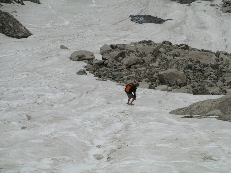
When we finally reached the saddle to drop back down to Long Lake, we found ourselves less than 250' below Apache Peak, but no will power to boulder hop to the top. Apache will have to be bagged another day. We started the slow loose scree descent. Not the scree skiing kind, but the ankle bruising type. We slowly picked our way through and to the top of the glacier above the lake. There was a snowboarder doing something down the glacier which resembled snowboarding, but they certainly weren't ripping it. We decided to show them how to rip a line.
Jeff ripping a line down the Glacier
Once we rejoined the trail, it was the longest 1.5 hr downhill hike out ever. My new boots are a bit too narrow and my dogs were barking! Besides that, I'm sure Jeff shared all the pains I was feeling from being on our feet for almost 19 hours. We slowly picked our way down the trail and lamented the fact that Long Lake seemed to be all too well appropriate of a name. I had us at just under 19 hrs car to car, 18hrs59mins. Hopefully you all just remember the 18 hour part....For this being the first time either of us stepped in the Indian Peaks Wilderness, it was quite the introduction.
My GPS Tracks on Google Maps (made from a .GPX file upload):
Just curious, why did you skip the bottom of the north face and skip up to the 5.7 pitch? Someday I’ll get off my rump and check out the Mohling traverse! Thanks for posting.
I’ve never heard of this traverse, and it’s always inspiring to hear something new! Not that I’ll be doing this any time soon, but inspiring none–the–less
Brian C – We skipped the first 9–10 pitches for the sake of time. Sure, if there was an awesome pitch in there some where, I would have been game. But honing the 5.0–5.5 wet rock/chimney skills isn’t something I felt I really needed to work on and could only hamper our chances of finishing Mohling. Maybe one day I will return to pitch out the entire North Face...
dubsho3000 – Thanks! I was onto Lone Eagle alone, but then I caught wind of the Mohling through some internet research.
Don’t. Having just climbed the North Face, I say the way you climbed just the money pitch and the pitch above it is the way to go. All the previous "pitches" were just not fun.
Caution: The information contained in this report may not be accurate and should not be the only resource used in preparation for your climb. Failure to have the necessary experience, physical conditioning, supplies or equipment can result in injury or death. 14ers.com and the author(s) of this report provide no warranties, either express or implied, that the information provided is accurate or reliable. By using the information provided, you agree to indemnify and hold harmless 14ers.com and the report author(s) with respect to any claims and demands against them, including any attorney fees and expenses. Please read the 14ers.com Safety and Disclaimer pages for more information.
Please respect private property: 14ers.com supports the rights of private landowners to determine how and by whom their land will be used. In Colorado, it is your responsibility to determine if land is private and to obtain the appropriate permission before entering the property.