Download Agreement, Release, and Acknowledgement of Risk:
You (the person requesting this file download) fully understand mountain climbing ("Activity") involves risks and dangers of serious bodily injury, including permanent disability, paralysis, and death ("Risks") and you fully accept and assume all such risks and all responsibility for losses, costs, and damages you incur as a result of your participation in this Activity.
You acknowledge that information in the file you have chosen to download may not be accurate and may contain errors. You agree to assume all risks when using this information and agree to release and discharge 14ers.com, 14ers Inc. and the author(s) of such information (collectively, the "Released Parties").
You hereby discharge the Released Parties from all damages, actions, claims and liabilities of any nature, specifically including, but not limited to, damages, actions, claims and liabilities arising from or related to the negligence of the Released Parties. You further agree to indemnify, hold harmless and defend 14ers.com, 14ers Inc. and each of the other Released Parties from and against any loss, damage, liability and expense, including costs and attorney fees, incurred by 14ers.com, 14ers Inc. or any of the other Released Parties as a result of you using information provided on the 14ers.com or 14ers Inc. websites.
You have read this agreement, fully understand its terms and intend it to be a complete and unconditional release of all liability to the greatest extent allowed by law and agree that if any portion of this agreement is held to be invalid the balance, notwithstanding, shall continue in full force and effect.
By clicking "OK" you agree to these terms. If you DO NOT agree, click "Cancel"...
Conundrum to Conundrum
Climbing Conundrum and Castle Peaks from Conundrum Hot Springs
Roundtrip Distance from the Hot Springs: 6 miles
Elevation Gain from the Hot Springs: 3,065'
Total Climb Time: about 10 hours
** EDITED **
I soloed this route again on 19 Sep 2015 and discovered a few things that may make the route safer and a bit easier for some. Well, it's 2017 and I'm finally getting around to updating the trip report. Hopefully, those planning their 2017 trip to Conundrum Hot Springs will find something useful in this report.
START of ORIGINAL REPORT
The route descriptions, photos and gpx in this write-up are from a successful climb of both peaks I made on 9 Aug 2014. I had tried this exact same route on 13 Jul 2013 and I made it to the top of Conundrum Peak but was rained out before I could hike the ridge to Castle Peak. I first learned of this route from a 2008 report by polarjud on Summit Post. I decided to finally post a trip report after reading about several instances of confusion concerning this route. Hopefully, this report will be helpful.
This route has no trail or trail markers. Good route finding skills are very helpful. In addition, it contains scree, some Class 3 climbing, exposure, and depending on the time of year some steep snow that has to be traversed. Please consider your own mountaineering experience before committing to this route.
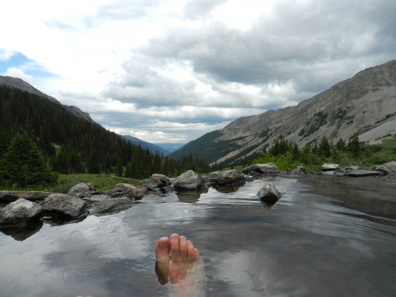
The approach up Conundrum Creek is absolutely beautiful. It is roughly 9 miles of wildflowers, beaver pools, aspen groves, and wonderful views. The 2,000' elevation gain is moderate but steady and never too steep. And, of course, there's a natural hot spring waiting for you at 11,200' to soak your tired legs. Be aware, that in the winter, this trail contains significant avalanche danger. Conundrum Creek Approach
Please practice low-impact camping around the hot springs. This is a rare spot in Colorado and sadly it is beginning to show signs of heavy use. Fires are not permitted around the springs and you must camp in the designated, first-come-first-serve camp spots. I highly encourage a mid-week trip if you can do it. You have a much better chance at getting a camp spot near the hot spring and you won't be elbow to elbow with others in the pool.
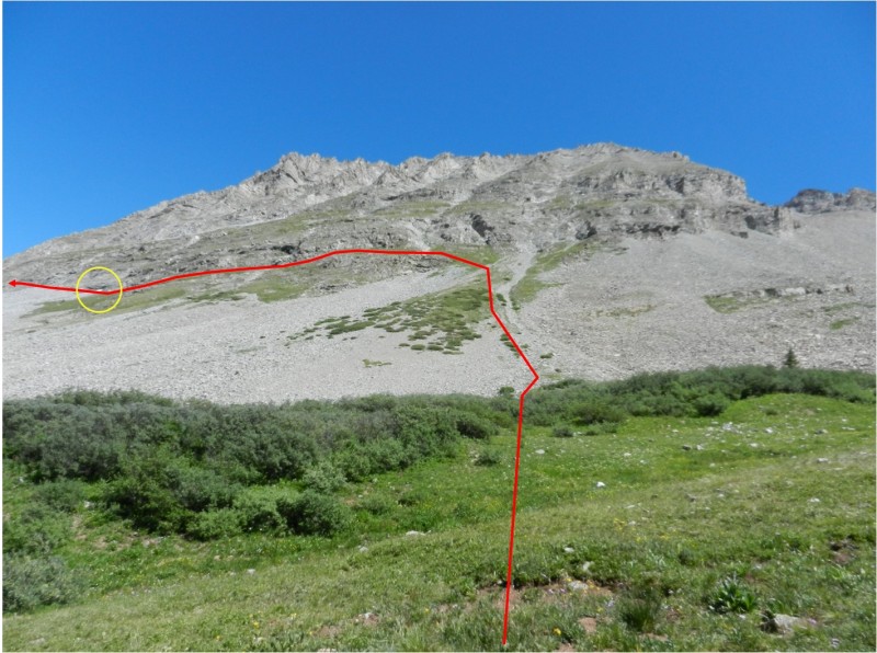
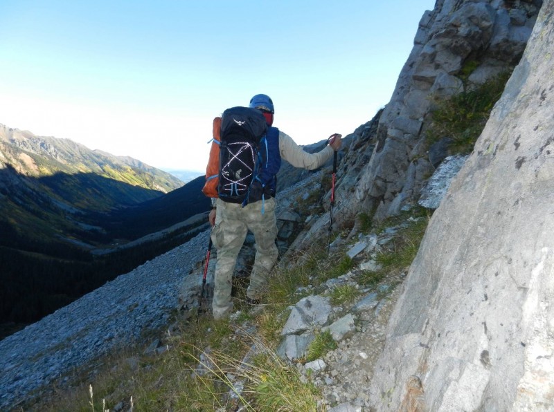
Begin the climb behind camp spot #13, east of the hot springs. Ascend directly up Castleabra's west slope to the cliff bands. At around 11,650', countour north along the base of the cliff bands for about 0.5 miles, keeping between 11,600' and 11,700'. Staying up at the base of the cliffs keeps you off most of the scree and provides easier footing. A helmet is a really good idea for this route.
Route Along Candleabra's West Slope
The yellow circle in the photo shows the location of a snow field that, depending on the time of year and snow pack, you can cross or circumnavigate. An ice axe will provide added security for early season climbs. In August 2014, the snow field was so small I simply travelled below it.
Here's a photo from my Sep 2015 trip showing the terrain along the base of the cliffs. Cliff Base Above Hot Springs
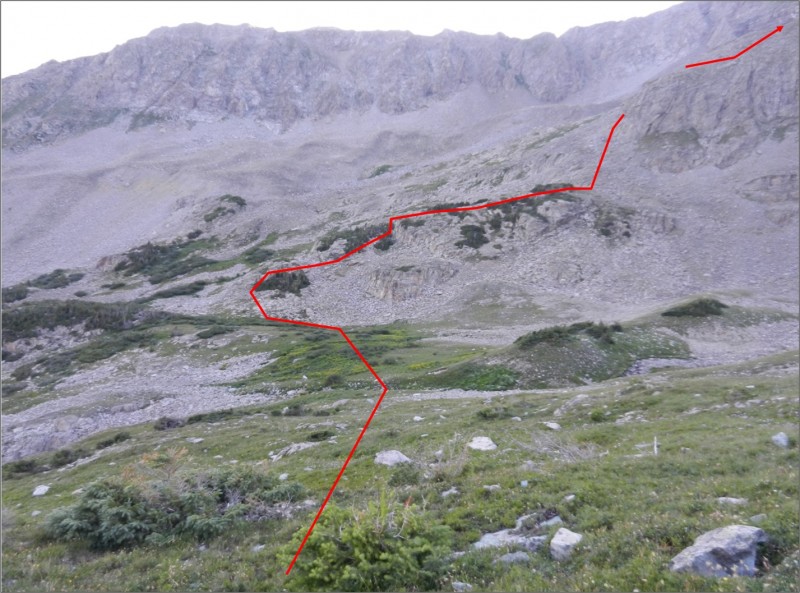
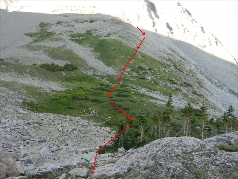
Eventually, you'll turn Castleabra's north ridge and enter a basin. Climb to about 11,800' as you enter the basin and aim for a small clump of trees on the far side which is the start of Conundrum's northwest ridge. Crossing the basin was really enjoyable. There is a small stream that is easily crossed. At the far side, you'll have to climb a bit of talus to get on the ridge. Route Through the Basin Looking Back at Route Through the Basin
Once on the start of the ridge, you'll get to experience some Class 3 climbing and a small amount of bushwhacking through the low-lying shrubs and trees. Find your own line through this section. You may be able to avoid the Class 3 climbing by continuing north past the clump of trees then angling back southeast to gain the ridge. Typical Class 3 Climbing in the Tree Section
During my Sep 2015 trip I was indeed able to avoid the Class 3 climbing by hiking further north past the start of the ridge, and then looking right to discover a pleasant, grassy ramp leading up about 80 yards to gain the ridge above the Class 3 section. Class 2 Option
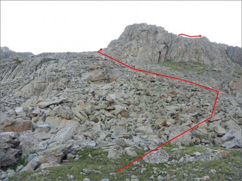
After exiting the trees, head for the lower ridge headwall and circle around it to climber's left in order to gain the true ridge. Route Around the Lower Headwall
At this point, the direction along the ridge is very clear. The ridge starts off somewhat broad, and then narrows to a more interesting degree. Take a good look at the weather before embarking on this long ridgeline. The climbing along the ridge stays at pretty much Class 2 on relatively solid rock (for the Elks) with a few exposed places. Ridge Route After the Lower Headwall Route Along the Narrow Ridge
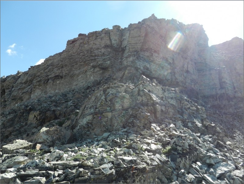
At about 13,700' on the ridge you'll encounter the imposing upper headwall. The Upper Headwall
Here, leave the ridge and traverse climber's right. Stay high near the cliffs for the best footing and to easily avoid the exposure on your right. Take your time through this section. It involves a bit of route finding. You'll have to lose a some precious elevation to clear your last obstacle to gain the scree slope leading to the ridge. Route to Climber's Right at Base of Upper Headwall
I have overlaid a section of my gpx track onto a GoogleEarth image to help you get a better idea of the upper route. The perspective on the GoogleEarth image makes the slope look a lot steeper than it actually is. gpx Plot on GoogleEarth Image Showing Upper Sedtion of Route
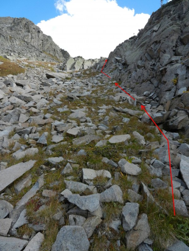
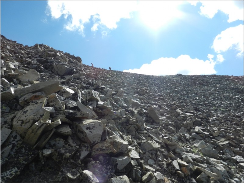
Step onto the open, relatively safe, scree slope leading to the ridge and climb the final 300' of slip-and-slide loose scree to the ridge between Conundrum Peak and Castle Peak. Final Scree Slope to Gain Ridge Between Conundrum and Castle Peaks
During my Sep 2015 climb I made use of a low rock rib in the scree slope running towards the saddle. You will fine the climbing on the rib easier and more stable compared to the small, loose scree surrounding it. Scree Rib
After gaining the ridge, there's a well defined trail leading climber's left to Conundrum Peak and right to Castle Peak. Looking Towards Conundrum Peak Looking Towards Castle Peak
Here again is a good time to take a critical look at the weather before heading up the ridge towards Castle Peak.
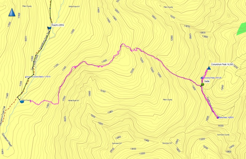
On the return, avoid the temptation to return via Roach's 25R4 route as shown by the dashed orange line in the map image below. I actually attempted this on my July 2013 climb to get off the ridge as quickly as possible when the storm rolled in. This route is miserable talus all the way down to the creek. And, crossing the creek to gain the Conundrum Creek trail was not a trivial task. Basically put, that route sucks. I do not recommend it. Instead, retrace your steps all the way back to the hot springs. Map Showing Entire Route (in red)
Here's the gps plot image from my Sep 2015 climb. I have also added the downloadable gpx file from my Sep 2015 climb. This time I carried my gps all the way to the true Conundrum summit! 19 Sep 2015 GPS Plot Image
Some final thoughts on this route:
- I consider the crux to be the Class 3+ climbing as you first gain the ridge. As indicated in my recent edit, you can avoid this section completely keeping the route at a Class 2+ to low 3. Still, there's definitely some loose boulder hopping you'll have to deal with.
- Another area of interest is when you leave the ridge at 13,700' and traverse to the scree slope. This requires a bit of route finding. You will have to lose some elevation to follow the safest line.
- When ascending the west slope of Castleabra, there's good footing in the green areas (see the photos).
- Concerning weather, this route is exposed with no good options for a quick retreat. Castle Peak is still a ways to go once you get to the saddle. Take a good look at the clouds before committing.
- Soaking a long time in the hot springs the night before can really leave you dehydrated for your climb the next morning if you're not careful. Drink a bunch of water while you soak.
- Finally, the water in the hot springs seems a little hotter and a bit more soothing on the legs after a successful climb. Enjoy!
Conundrum Hot Springs
My GPS Tracks on Google Maps (made from a .GPX file upload):
This is the exact route I ended up doing when the Summitpost route description failed me.
Edit: Your traverse from Con West Ridge to the right to attain the Castle/Con saddle is somewhat higher than my traverse when I did this a few years ago. I am very interested to try your version, as it’s probably more enjoyable.
Wow. This is the route I have been contemplating for years, just never got around to doing it. You did it!! After trying the horrid "Roach" route from that side, I had heard there might be a better way. THIS way. Congratulations! Great write up. This needs to be added to the Routes page here.
Looking at your GPS it doesn’t appear that you actually made the summit of Conundrum. True summit is the 2nd bump on the ridge towards Cathedral, just past the Conundrum couloir. Nice work otherwise.
Painless4u2 – see the GPS tracks on some of the recent Conundrum reports (Bergsteigen, DavidLeVan, Jmanner) and see where their tracks were (again, summit is to the right of the Conundrum couloir, not before)
On review, it does appear he was about 50 feet short in elevation, as well as short in distance. I stand corrected. Perhaps a GPS error? What do you say, youngk2844?
The answer to the mystery is... I’m lazy. I dropped my pack (with GPS inside) at the first bump and walked sans pack to the true summit. I grabbed my camera but totally forgot to grab the GPS. It was a lack of oxygen thing...
...will answer many questions on that recurring thread! I have some real sick (minded) friends that insist on getting these peaks from that side.
They have been shut down once... this will insure that doesn’t happen again! Thanks for writing this up!
Thanks for this great report, I love exploring nonstandard routes! Made a pretty feeble attempt at this this weekend, should have kept in mind that traversing over Elks scree would take much longer than the same mileage elsewhere. Will note that along the cliffs and the northern shoulder just before the basin opens up for the most part there is now a recognizable social trail that follows the most reasonable path forward. From the talk of the hot springs it seems like this is known local route.
I turned back at the nice meadow in the basin with full view of the Castle-Conundrum cirque and felt that was worthwhile in itself, stunning! I decided to bail down toward the creek instead of crossing along the cliffs again which was still steep and treacherous, went for a ride down a gully full of marsh plants and I think I ran into an occupied moose den closer to the creek. Found a nice crossing spot across from campsite 17 at least and took the trail back to camp.
I think next time I might try going for the 13ers at the end of the valley like Triangle or UN 13214 from the Triangle Pass trail instead of re-attempting this route. It does look like exciting, but the gain and scree traversing might be a bit much for me on top of the 8-mile pack hump just to get to the start!
Found little bits and pieces of this local route scattered about- yours is the first I've found that covers it in full! Scouting it out then trying it in a couple days as weather permits. Thank you!
JayhawkArcher, good luck on your attempt. I'm interested in hearing how it goes.
Caution: The information contained in this report may not be accurate and should not be the only resource used in preparation for your climb. Failure to have the necessary experience, physical conditioning, supplies or equipment can result in injury or death. 14ers.com and the author(s) of this report provide no warranties, either express or implied, that the information provided is accurate or reliable. By using the information provided, you agree to indemnify and hold harmless 14ers.com and the report author(s) with respect to any claims and demands against them, including any attorney fees and expenses. Please read the 14ers.com Safety and Disclaimer pages for more information.
Please respect private property: 14ers.com supports the rights of private landowners to determine how and by whom their land will be used. In Colorado, it is your responsibility to determine if land is private and to obtain the appropriate permission before entering the property.


 Scree Slope Rib")


