Download Agreement, Release, and Acknowledgement of Risk:
You (the person requesting this file download) fully understand mountain climbing ("Activity") involves risks and dangers of serious bodily injury, including permanent disability, paralysis, and death ("Risks") and you fully accept and assume all such risks and all responsibility for losses, costs, and damages you incur as a result of your participation in this Activity.
You acknowledge that information in the file you have chosen to download may not be accurate and may contain errors. You agree to assume all risks when using this information and agree to release and discharge 14ers.com, 14ers Inc. and the author(s) of such information (collectively, the "Released Parties").
You hereby discharge the Released Parties from all damages, actions, claims and liabilities of any nature, specifically including, but not limited to, damages, actions, claims and liabilities arising from or related to the negligence of the Released Parties. You further agree to indemnify, hold harmless and defend 14ers.com, 14ers Inc. and each of the other Released Parties from and against any loss, damage, liability and expense, including costs and attorney fees, incurred by 14ers.com, 14ers Inc. or any of the other Released Parties as a result of you using information provided on the 14ers.com or 14ers Inc. websites.
You have read this agreement, fully understand its terms and intend it to be a complete and unconditional release of all liability to the greatest extent allowed by law and agree that if any portion of this agreement is held to be invalid the balance, notwithstanding, shall continue in full force and effect.
By clicking "OK" you agree to these terms. If you DO NOT agree, click "Cancel"...
Ellingwood via Zapata Falls and the Use-less trail
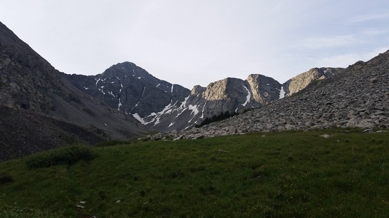
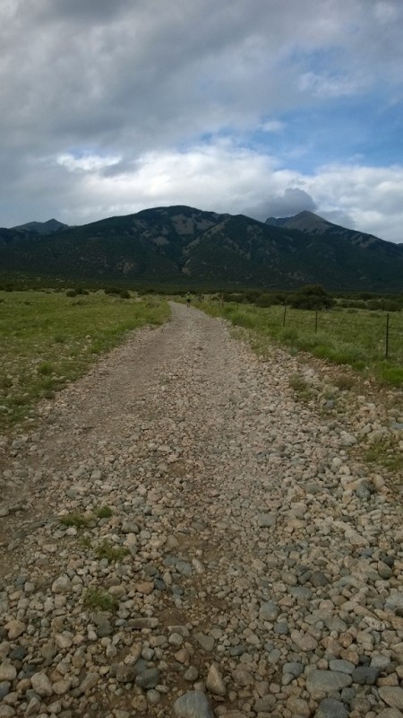
We started at 4:30am, and began by making great progress. The trail is very well defined all the way to S. Zapata Lake. Ellingwood way in the distance after the sun came up Ellingwood at its base
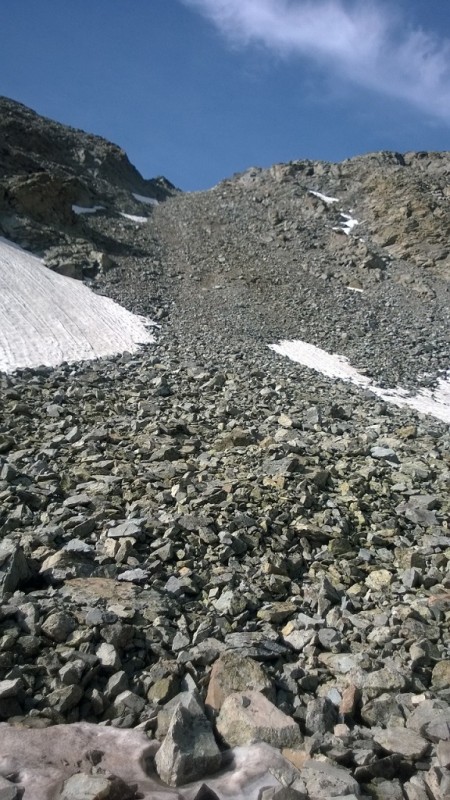
The marshes around the lake were full, and we got our feet soaked while trying to navigate them. Due to reports of the conditions in the C2 couloir, we decided to take C3 gully. We got a little confused as to how to get there from the lake, but after looking at the topo map, made the right choice and went straight up the grassy area by the lake. It takes a bit before you reach C3, and you have to ascend a smaller gully along the way before you can even see it. Up the Useless trail
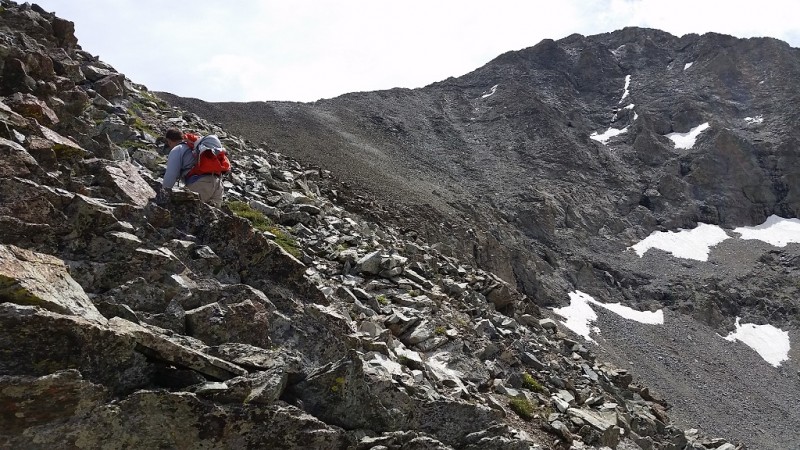
This is where our pace slowed considerably. The route description says there is a "use" trail up the gully, it was more of a "useless" trail. It was not a contiguous trail and was made up of steep slippery dirt. Trying to climb the rock instead of the trail was a challenge as well since it was large, loose rocks. After achieving the gully, we started up the ridge line. Ridgeline after C3
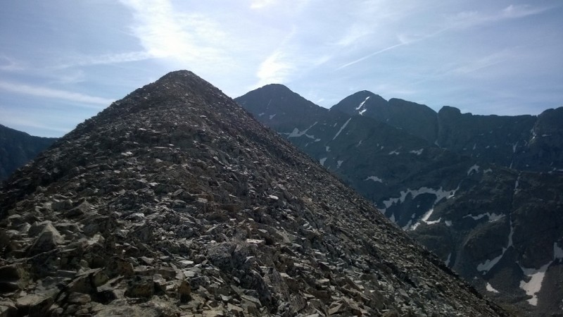
There is no trail, and the rock sucked. It was comprised of large loose rocks, none of which you could trust. You gain and lose elevation several times. More Ridgeline Another ascent along to stay on the ridgeline
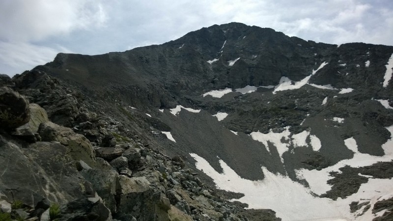
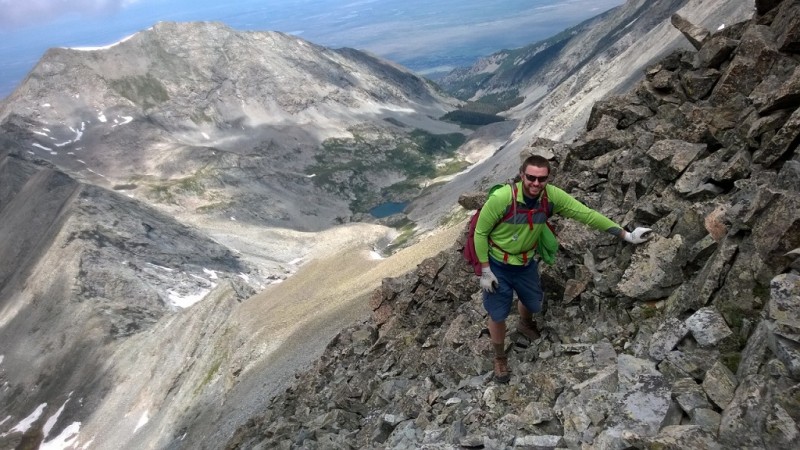
The view of Ellingwood Pt. is always there and a little discouraging since the pace was so slow and the summit did not appear to be getting any closer. This was definitely the worst part of the climb. After you dip down in elevation for the final time you end up at just under 13,000 ft. Our legs were pretty exhausted as we had already traveled 4,600 vertical over 7 miles. The next 700 feet of vertical was straight up a talus field. The rock here was much smaller and more stable, but was killer on the fatigued quads. Higher up the ridgeline Higher up the ridgeline before the Class 3 section
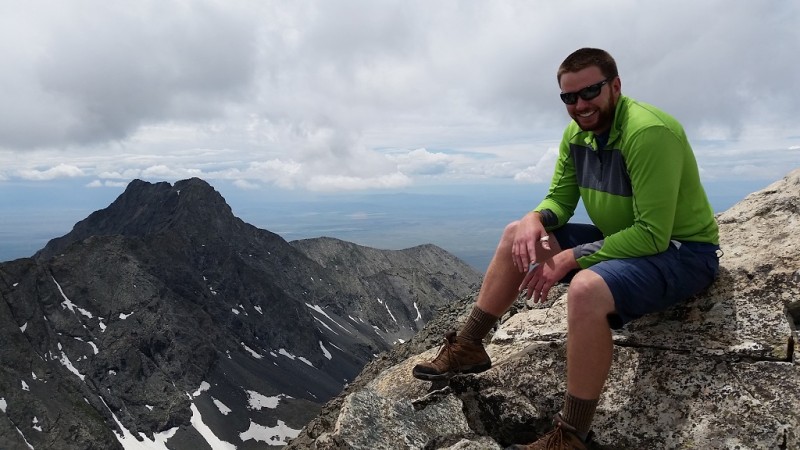
After this, the steepness relented and our pace picked back up. The final pitch was class 3. The rock was relatively solid and we picked our lines over several pitches as we made our way to the summit. It was a fun scramble with some exposure that made it a good challenge. We summited around 12:30, later than we expected. Dan on the top with Little Bear in the background Michael on the top with Little Bear in the background
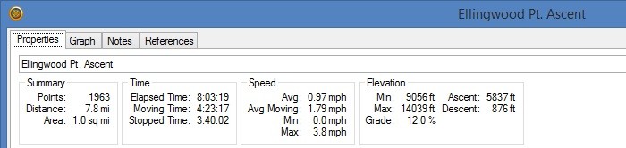
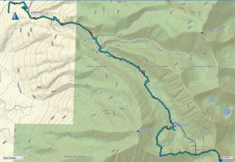
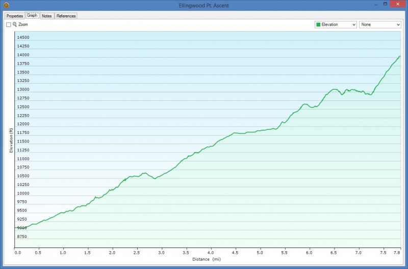
Per the GPS, we had traveled 7.8 miles and had an elevation gain of 5,837 ft. This was close to the elevation gain listed on the route description, but over 1 ½ miles longer than what it says. GPS Stats GPS Map GPS Elevation Plot
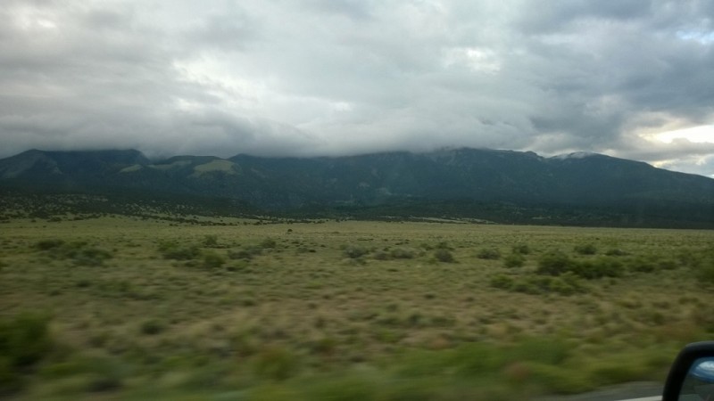
On the summit we were seeing a change in the weather and made a drastic decision. If we were to return the way we came, we would be exposed on the ridge for a long time. If the rain came in, the loose rock and C3 gully could get ugly. So we opted to go down the standard route and hike down the Lake Como road hoping that at the bottom we could hitch a ride back to the Zapata Falls TH. The hike down was long and uneventful. There were only three vehicles left at the lower trailhead, but we got lucky and a guy by the name of Jason gave us a ride back to Zapata Falls. Thanks again Jason if you are reading this. Down toward the bottom of Lake Como Rd Socked in mountains on the drive out
In summary, this is a long, challenging hike/climb. If I had to do it over again, I would have either left the TH earlier, or hiked up to tree line, camped, then summited. If it was a different time of year I would have entertained the idea of going up the C2 gully. This would have shaved off a lot of distance, a lot of elevation gain/loss, and most importantly, avoided the crap rock along the ridgeline.
My GPS Tracks on Google Maps (made from a .GPX file upload):
Thanks for the trip report! You mentioned that if conditions were different you would have done the C2 coulier instead of C3, is that due to the lack of snow coverage in C2? Thanks, –Hart
Hart: We decided against it due to the soft snow on a previous Condition Update of a failed attempt. It was warm the day we went and there was still plenty of snow in C2. Our assumption was that we would encounter the same conditions from the previous attempt. It would be difficult to have tried C2 then reverted to C3 if not successful. If you are going to camp at the lake or tree line, you could probably scout C2 the afternoon prior. This would tell you which option is best. Good luck and let me know how your trip goes.
yeah that was me who failed because of dangerous snow conditions in the C2. I entertained the idea of trying to pick my way up to the C3 but didn’t actually know what it looked like and from the C2 it would have been a long freaking time until summit and back.
Does anyone know exactly how awful the C2 is without snow? Doable?
We climbed Ellingwood late last summer from Zapata Creek trail. We went up C2 and part of our group split came back down C2 and three of us including myself went down C3. My conclusion is – the only reason to go via C3 is if there’s ice/snow that can’t be climbed in C2 and C3 is dry. C3 is a LOT longer. We didn’t follow the recommendation to stay on those three ridges to get back from the top of C2 to C3. Indeed, the talus was VERY loose and VERY steep.
Climbing and descending C2 which was dry was difficult but better than the C3 alternative.
The two times I did C2 was in summer and it was bone dry. Yeah, it’s loose and yeah, it’s a pain in the a@@, but it is definitely doable. Going up, I found staying on the left side against the rocks worked best for me and coming down, I was able to do a little scree–surfing. Don’t know that I’d want to do it a 3rd time – maybe in snow it would be fun, tho.
I snow climbed C2 on June 26th this season....it was just still in snow wise and made a fine snow climb and fun way to tag ellingwood pt. I descended/glissaded down it as well. Glad there was still continuous snow(barely tho) as it would not have been fun dry. Screw that crap....lol. Ran into two guys a few hundred feet before the trailhead heading up with packs as an overnighter trying to attempt it the next day. Never heard if they made it or not.
My wife and I hiked up and down C2 yesterday (Sunday July 12th) there is a small strip of snow near center of C2, however it is completely avoidable. The hike up was easier than the hike back down (in our opinion ) after summiting both Ellingwood and Blanca, our legs were tired and it seemed like a lot of work to control ourselves on all of the loose rock as we came down. I think it may have actually taken as long or slightly longer coming down C2 as it did going up it. We really liked the Zappata Lake area/basin (only saw a few other people all weekend and no bear activity)however we personally would not hike C2 again.
everybody is talking about C2 and C3 routes, what about C1?
Never mind (slams palm into forehead :oops: )
Caution: The information contained in this report may not be accurate and should not be the only resource used in preparation for your climb. Failure to have the necessary experience, physical conditioning, supplies or equipment can result in injury or death. 14ers.com and the author(s) of this report provide no warranties, either express or implied, that the information provided is accurate or reliable. By using the information provided, you agree to indemnify and hold harmless 14ers.com and the report author(s) with respect to any claims and demands against them, including any attorney fees and expenses. Please read the 14ers.com Safety and Disclaimer pages for more information.
Please respect private property: 14ers.com supports the rights of private landowners to determine how and by whom their land will be used. In Colorado, it is your responsibility to determine if land is private and to obtain the appropriate permission before entering the property.