Download Agreement, Release, and Acknowledgement of Risk:
You (the person requesting this file download) fully understand mountain climbing ("Activity") involves risks and dangers of serious bodily injury, including permanent disability, paralysis, and death ("Risks") and you fully accept and assume all such risks and all responsibility for losses, costs, and damages you incur as a result of your participation in this Activity.
You acknowledge that information in the file you have chosen to download may not be accurate and may contain errors. You agree to assume all risks when using this information and agree to release and discharge 14ers.com, 14ers Inc. and the author(s) of such information (collectively, the "Released Parties").
You hereby discharge the Released Parties from all damages, actions, claims and liabilities of any nature, specifically including, but not limited to, damages, actions, claims and liabilities arising from or related to the negligence of the Released Parties. You further agree to indemnify, hold harmless and defend 14ers.com, 14ers Inc. and each of the other Released Parties from and against any loss, damage, liability and expense, including costs and attorney fees, incurred by 14ers.com, 14ers Inc. or any of the other Released Parties as a result of you using information provided on the 14ers.com or 14ers Inc. websites.
You have read this agreement, fully understand its terms and intend it to be a complete and unconditional release of all liability to the greatest extent allowed by law and agree that if any portion of this agreement is held to be invalid the balance, notwithstanding, shall continue in full force and effect.
By clicking "OK" you agree to these terms. If you DO NOT agree, click "Cancel"...
On July 1 my dad and I decided to change it up and climb more of an unpopular 13er in the Crested Butte area, so we chose Precarious. It has a pretty legit name so that's why I chose it. I had done some basic research on this mountain by finding a few reports on it and Google Earth, but nothing really in depth so I just had to check it out myself. We were out the door by 5:30 and at the Rustler's Gulch TH by 6:30 (biked to TH). The Rustler's Gulch trail is at its prime at this time and was totally vibrant with flowers scattered all over the valley.
A look down Rustler's Gulch with Precarious on the left
The hike is pretty gradual until you reach a fork in the singletrack, a double-track will follow to the right to what used to be a mine; and the left singletrack follows to the base of Precarious ending at an extensive scree field where the "standard" gully route is used.
Fork in the trail, take a left.
Gaining the ridge line before the actual mountain seemed like the best plan of attack judging from looking a a huge boulder field at the base of the peak which led to a common gully route, we didn't want to deal with the boulders at that time however.
We strayed off the singletrack to the left and pushed up the steep grassy hill headed towards a bowl to the left of the peak.
Headed up the grassy hill. Sorry for the finger, the sun was ruining the lighting in the shot!
Once at the top of the grassy hill you come upon a typical scree field with toaster and mini fridge sized rocks. This was alright, every mountain has a lot of rocks...
Looking up at the rocks, the ridge line lies above.
A look at the gnarly ankle shredders.
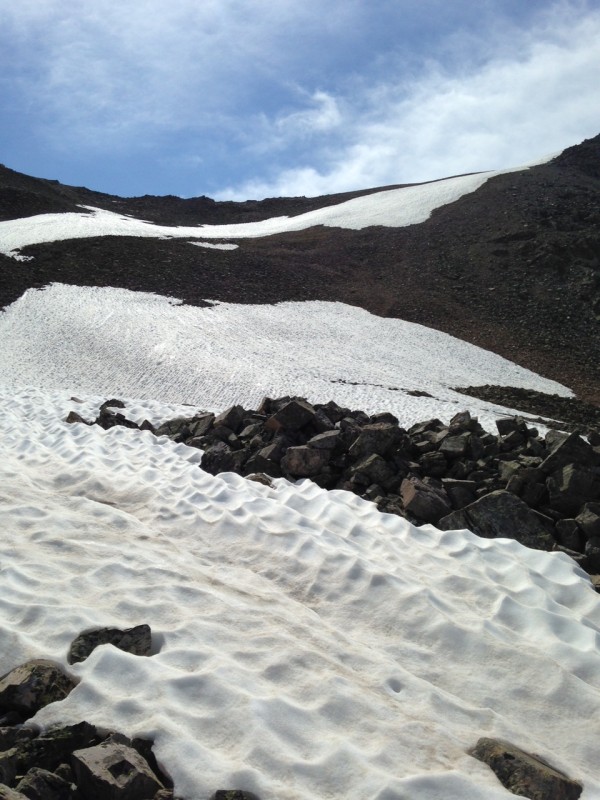
There was a snowfield that helped us clear some of the rocks. Didn't have any spikes or snow gear because it's July, just the ol Merrill Moab Ventilator trail shoes.
Thank sweet baby Jesus for the snow.
After some heavy breathing and wet socks, we finally reached the ridge!
A look back down the basin with the ol Man in the distance
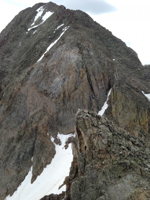
Once on top of the ridge, the ominous looking Precarious Peak loomed over us. We finally got to see how challenging it looked from a real world perspective and not the 2 other photos of it on the internet (if even that).
Precarious to the left with a sweet looking spike formation to the right.
We pressed on and reached the top of the false peak.
Looking up to the peak
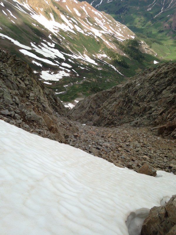
Once you down climb off the false peak you reach the top of the gully that some people decide to climb up. I don;t have any idea why people would want to climb up that, it looks ultra steep and loose.
Down the gully into the abyss...
We then got a nice visual of the garbage that we would be climbing for the rest of the day until the peak.
Such quality hiking for a few flat landers...!
This mountain would be fantastic if you like scrambling over steep and loose rock formations. I was climbing up a narrow notch soon after and dislodged a huge rock that I swore was part of the mountain, it jammed into my leg and I had to catch it or else it would've rolled and done an unquestionable amount of damage to my dad. I had to tell him to move and climb to a safer area behind a few large boulders before I unpinned my leg from the stone and it flew down the mountain bringing hundreds of other rocks with it. BE CAREFUL WHICH ROCK YOU GRAB ON TO! Always be sure to have at least 2 points of solid contact that you can catch yourself with.
After some more steep climbing, we reached a notch nearing the peak. You could down climb from this notch into the central part of a 'V' shaped gully, but it is super steep, difficult class 3 if not class 4 in my opinion.
A look across the 'V' to a massive slab. About 70 feet tall it looked like.
You could probably climb up this slab ^^^ by keeping one foot on it and one on the left rocks, but that was too sketchy. This slab is much steeper than this picture gives it unfortunately so we decided to back track about 40 feet before the 'V' and traverse to the left (facing the peak) around to the back side of the mountain in hopes to avoid the slab and down climbing into the 'V'.
The highest snow patch in photo #8 (looks really small) is the one we had to traverse over on the backside of the 'V' in order to get past that part and get to the peak. The snow patch at this time was about 14 feet wide but had dire consequences if we slipped... We crossed it the old fashioned way by clawing the snow and jamming out shoes into it to get a secure step.
Once across this there was about 75 feet left in elevation to the peak. Once again a short but difficult class 3 (probably class 4 I felt like I needed ropes) ascent to about 35 feet below the peak. These rocks are extremely loose and I almost pulled out another huge one which completely threw off my balance, luckily I caught myself
Finally, after 7.5 hours we reached the summit, the clouds were turning grey but we were just happy to be on top.
On the summit facing towards White Rock Mountain, views of the front face also
My dad basking in the superior mountaineering feat
After a mediocre but tasty PB&J we decided to bail off the peak because of the weather. However, the ascent was extremely sketchy and we couldn't really see ourselves going back down that way so we walked off the peak into a gully facing the side of Rustler's Gulch. It wasn't too bad until about 100 feet into it. Then it got steep, not unhikeable, but just very steep. There was more dirt on this side which caused our shoes to slip a often when we weren't stepping on backpack sized loose rocks.
This is what the descent was like the entire way until the base.
We had to be extremely careful because it would be very easy to break an ankle or leg on this. We continued down the mountain until we were faced with a cliff face under our feet so we had to traverse to the left into a secondary gully and keep going down. It's only a quarter mile down the face directly but it probably took us an hour to get down to the base into the boulder field.
My dad inching down the face trying not to slip
Now the descent was absolute trash but once we hit that boulder field our positive vibes had disappeared... Immediately we were nailed by a hailstorm lasting about 20 minutes drenching all the rocks making them slick. Great. We still had half a mile of mini fridge sized super loose rocks to scurry over.
We aimed for every patch of snow there was just to give our feet and knees a break. And it took about 45 more minutes to get fully across the boulders safely and back onto dirt. Dirt has never felt so good.
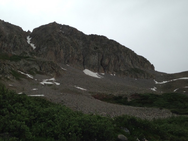
Taking a look back at the mountain. The snowed in gully (one route) to the left. We exited the mountain out of a gully just o
After the 4 mile hike back to the end of Rustler's, I would not go on this climb again. I now understand why it is named Precarious Peak and why no one climbs it ever.
However, if you want to, be sure to be extremely careful with finding firm rocks to grab and being confident with your technical moves. Be ready to climb complete crap and descend it too. The hike in is absolutely beautiful and so is the entire climb, you just have to be focused. It turned out to be a full 12 hour day despite it being somewhat close to Crested Butte.
Thumbnails for uploaded photos (click to open slideshow):
Kudos for going after Precarious! Quite the choice and nice tour too – hadn’t heard of any ascents via the NW ridge (?) nor many descents to the W. Most do it via a nightmarish southern gully or as a snowclimb via the N or S coulies. Speaking of which, careful starting rockslides down the sides of a peak – I’ve nearly been beaned a couple times by people not expecting others on a different route!
Yeah definitely more of a random line choice but that seemed best because we did not want to hike up that gully with snow still in it, my dad was even in his Keens! As for the rockslides, you’re definitely right about that haha
Caution: The information contained in this report may not be accurate and should not be the only resource used in preparation for your climb. Failure to have the necessary experience, physical conditioning, supplies or equipment can result in injury or death. 14ers.com and the author(s) of this report provide no warranties, either express or implied, that the information provided is accurate or reliable. By using the information provided, you agree to indemnify and hold harmless 14ers.com and the report author(s) with respect to any claims and demands against them, including any attorney fees and expenses. Please read the 14ers.com Safety and Disclaimer pages for more information.
Please respect private property: 14ers.com supports the rights of private landowners to determine how and by whom their land will be used. In Colorado, it is your responsibility to determine if land is private and to obtain the appropriate permission before entering the property.


 A look down Rustler's Gulch with Precarious on the left")
 Fork in the trail, take a left.")
 Headed up the grassy hill. Sorry for the finger, the sun was ruining the lighting in the shot!")
 Looking up at the rocks, the ridge line lies above.")
 A look at the gnarly ankle shredders.")
 Thank sweet baby Jesus for the snow.")
 A look back down the basin with the ol Man in the distance")
 Precarious to the left with a sweet looking spike formation to the right.")
 Looking up to the peak")
 Such quality hiking for a few flat landers...!")
 Down the gully into the abyss...")
 A look across the 'V' to a massive slab. About 70 feet tall it looked like.")
 On the summit facing towards White Rock Mountain, views of the front face also")
 My dad basking in the superior mountaineering feat")
 This is what the descent was like the entire way until the base.")
 My dad inching down the face trying not to slip")
 Taking a look back at the mountain. The snowed in gully (one route) to the left. We exited the mountain out of a gully just o")


