June 17, 2015
Trailhead: Sunshine Mesa
Ascent: North Face and East ridge from Bilk Basin, Descent: North ridge
Mileage: ~13 miles
Vertical: 4,400 ft
Time: under 12 hours
Max speed: 30 mph
Partner: Brittany and Jaaron
As I was nearing the finish line of the Centennial project, two peaks loomed high over my head - Gladstone and Thunder. I knew I would prefer to do them with snow, but conditions just didn't seem to align. Mike S (moneymike) and I have already made an attempt to ski Gladstone on May 12 this year, but the timing and conditions were not right, so we turned around 400 ft below the summit on the SE face.
May 12, 2015

Gladstone attempt 05.12.15 from Lizard Head pass - SE Face

On the approach from Lizard Head pass. Soon-to-be 14er ski finisher - moneymike
About 400 ft from the summit, snow deepened to 2-3 feet of unconsolidated powder (we attempted too soon after a recent storm).

Approaching the "bench" and breaking through 2+ feet of powder
Mike and I are not known for turning around easily from our objectives, but I could not have been more certain that it was the right thing to do that day.

Some windloading on the traverse just below the summit ridge gave me a serious pause.
With tail between our legs we retreated. At least skiing in deep powder was good.


Styling it - moneymike

A month later, I find the project stalled. Lack of overnight freeze, unstable weather, and lack of partners. Those are not trivial peaks and Gladstone is especially far away, so partners are hard to come by. Luckily, Jaaron has expressed interest in skiing the peak and we make initial plans. That same week, Brittany contacted me and offered to ski it together on Wednesday. Now, if I could get everyone's calendars align for the attempt? Jaaron rises to the occasion taking a day off work, and we solidify the plans. This time, we will attempt from the North - from the Sunshine mesa TH via Bilk Basin.
June 17, 2015
Brittany has already covered the trip in her excellent blog post, so I just post a few photos as teasers. Rougher approach, but much less snow, more stable and spring-line snowpack, and we had a shot at this elusive Centennial.

Lizard Head looks on as Brittany and Jaaron skin through the Bilk basin

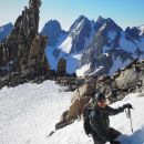
Gladstone's North face towers over an incredibly blue lake

Jaaron, Brittany and Wilson Peak

The North face steeps near the ridge - Natalie and Jaaron. Photo credit: Brittany

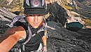
Delicate scrambling on the loose and exposed East ridge, just below the summit - Brittany

My very motivated partner - thank you so much for helping me with this project, Brittany. Photo credit: Jaaron

Starting to move some snow just below the top - Natalie

Jaaron skiing the North face. Photo credit: Brittany

Skiing North face - Natalie

Finishing the ski - Brittany. Photo credit: Jaaron

Wilsons and Gladstone on the drive out
June 21, 2015
Trailhead: Maroon Lake
Route: West slopes - White gully ascent and descent
Mileage: ~13 miles
Vertical: 4,900 ft
Time: ~12.5 hours
Beta: USAKeller's report
Partner: solo
After completing Gladstone in rather challenging conditions with two of my much more experience partners, I felt mentally prepared and motivated to attempt the Thunder Pyramid. Steve Gladbach's accident on the peak in June of 2013 put a wrench in my abilities to think about this peak as just another mountain. Last year I ran circles around the peak unable to pull the trigger on the attempt. This time, I carefully considered the optimal conditions that I deemed necessary for the attempt to be successful and safe: clear overnight skies that would enable overnight freeze, shaded Western aspect, GPS track with the route, good weather that day and good physical conditioning. Additional factors, such as previous successful solo summits by Doggler and Rainier Wolfcastle, and Monster5's assurance that peak is a reasonable challenge in stable spring snow, contributed to the decision to at least try a solo attempt.
Needing a good night of sleep, I launched from Maroon lake's overnight parking lot a quarter past 4am (a bit later than I hoped, but I was betting that the western aspect of the route would grant me a couple of hours of extra time before the sun boils the snow). As I was hiking in the dark past Pyramid, I was getting an idea that there was very little snow remaining on the western slopes (temperatures in the past week have been in the 60ties). As soon as I got a first good impression of the route from Maroon creek crossing soon after sunrise, the easy decision was made - leave the skis at the bottom. The raging Maroon creek forced me to deviate from Caroline's route initially, but detour wasn't bad. My camera recently broke, so Android phone photos will have to do.

Maroon creek crossing

Some neat waterfalls on the route

As I got to the Len Shoemaker's basin near 12k, I made a conscientious decision to closely stick to Caroline's route, even if initially it didn't seem to make sense.

Black cliff that guards the bottom of the White gully
Much to my surprise, there was almost no snow in the White gully to about 12.5k, when I stopped and changed from trailrunners into ski boots. The snow was intermittent and/or avoidable to about 13k.

After the continuous snow started, I ran into frozen tracks made by the party of 3 who ascended a day earlier. Things were looking up. Snow was in great condition and still frozen around 10am (yay for Western aspect which didn't get any sun before 8.30-9am).

Snow ended couple of hundred feet below the summit ridge. Although it was a bit awkward, I had to be careful stomping around in ski boots on loose terrain.

Cairns on the ridge route

2nd successful party of the season. Thanks for the booter, Uwe!

Bells with a large group that day on Bell Cord
With conditions being so favorable and still feeling pretty good after ~7hr ascent, I briefly considered the traverse to Lightning Pyramid, but a few factors dissuaded me - clunky(ish) ski boots not particularly suited for loose ridge scrambles, not enough familiarity with the descent route off Lightning and no cell reception. So not to push my luck, down the familiar route I went.

A bit loose start of the White gully

Post 11am, snow finally started softening up

Looking from the bottom of the White gully

After putting trail shoes back on around 12.5k, I carefully made my way down to the creek, closely following Caroline's route

Summer conditions lower on the mountain

Creek crossing was still a challenge in gushing water, but it actually felt pretty good. Then came the comical part. After picking up my skis, I had to endure a walk with them back to Maroon lake with people asking if I skied anything today. I did my best to avoid discussion of probable ski lines... Back at the car after 12.5 hour day.


Not much snow left for skiing
My GPS Tracks on Google Maps (made from a .GPX file upload):
|