Download Agreement, Release, and Acknowledgement of Risk:
You (the person requesting this file download) fully understand mountain climbing ("Activity") involves risks and dangers of serious bodily injury, including permanent disability, paralysis, and death ("Risks") and you fully accept and assume all such risks and all responsibility for losses, costs, and damages you incur as a result of your participation in this Activity.
You acknowledge that information in the file you have chosen to download may not be accurate and may contain errors. You agree to assume all risks when using this information and agree to release and discharge 14ers.com, 14ers Inc. and the author(s) of such information (collectively, the "Released Parties").
You hereby discharge the Released Parties from all damages, actions, claims and liabilities of any nature, specifically including, but not limited to, damages, actions, claims and liabilities arising from or related to the negligence of the Released Parties. You further agree to indemnify, hold harmless and defend 14ers.com, 14ers Inc. and each of the other Released Parties from and against any loss, damage, liability and expense, including costs and attorney fees, incurred by 14ers.com, 14ers Inc. or any of the other Released Parties as a result of you using information provided on the 14ers.com or 14ers Inc. websites.
You have read this agreement, fully understand its terms and intend it to be a complete and unconditional release of all liability to the greatest extent allowed by law and agree that if any portion of this agreement is held to be invalid the balance, notwithstanding, shall continue in full force and effect.
By clicking "OK" you agree to these terms. If you DO NOT agree, click "Cancel"...
There aren't very many reports of Atlantic's West Ridge in Winter Conditions so this report will aim to fill in some of that gap.
***
Added 3/28/15: Just finished a great compilation of videos taken during the climb, here's the link to it.
***
I first came across this route in the book "Colorado Snow Climbs" by Dave and James Cooper. They claimed it was an excellent introduction to winter snow climbing. Living in West Texas, I get one week a year in CO in calendar winter, so I have to make them count, and the pictures of this looked like it fit the bill. I contacted my old climbing partner Nathan (HighonThinAir) whom I climbed the Angel of Shavano with last June, and we agreed to camp at the trailhead and go for an alpine start to avoid the inevitable post-holing that would come with the warm temps.
Before I go any further, a huge shout-out to the group who did this route a week ago and put the trench in for us all the way to the ridge. Your tracks were much appreciated on the ascent and especially the descent.
I arrived at Mayflower Gulch TH Monday afternoon and scouted the first mile of the road looking for decent places to camp. There weren't any. Fortunately, the snow berm plowed against the west side of the parking lot offered some privacy, so I stomped out a platform for a tent on the other side of it, and whalah, I'm sleeping thirty feet from my car.
Despite setting the goal to be on the trail at 6am, the inevitable slogginess of alpine mornings dragged our preparations out and we didn't get going until close to 645. The moon hung over the peak above as the sun began displacing it.
The road goes up about a mile and a half to some old mining ruins.
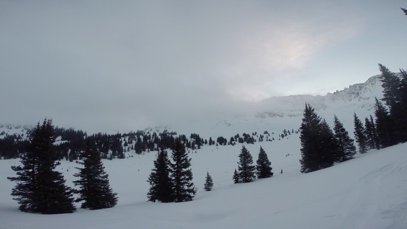
We didn't go all the way to the mine. After around a mile, we paused to watch some fog descend into the basin before crossing Mayflower Gulch, piecing together different ski tracks.
I was nervous about losing the trench which I had planned on meeting up with on the other side of the basin, but we got lucky and came right across it, saving us a tedious search for it in the deep snow and fog.
For the next 45 minutes we wandered through the fog, following the trench from the previous group. The few times we strayed from it, we sank to our knees, even in the early-morning cold.
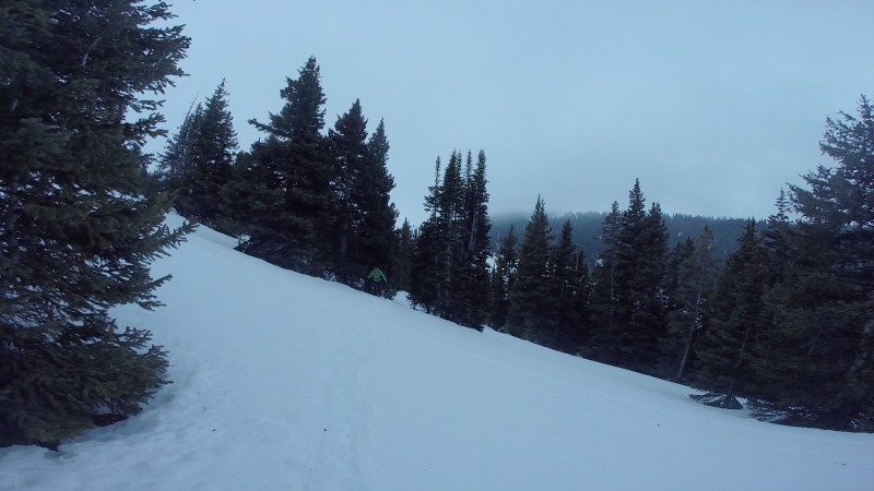
My biggest safety concern of the day was how to get onto the ridge-proper. The summer route goes pretty far north of the start of the ridgeline before turning back east/southeast to join the ridge. I wanted to avoid those north-facing slopes, and the conditions report from the earlier group verified that they did as well. We continued following their trench without pause until coming to this slope.
The angle registered at 32 degrees (as reported by the only other person we met on the mountain that day), and it was a large open slope without a lot of anchors and with a shady runout into a deep depression in the trees. Nathan and I stopped and kind of just looked at it for a few minutes. The trench we had followed up until that point skirted this slope on climber's right and bounced from anchor to anchor, but these anchors were spread apart and really were just a few isolated trees or boulders. The thick fog prevented us from seeing other possible routes and also contributed to a sense of foreboding. We talked it through for about ten minutes before committing to getting across it. That morning it was certainly stable: our biggest concern was on the descent, especially as evidenced by all the recent wet-slab activity we both drove by on the way to the TH. I figured we had a few things going for us though. The thick fog would keep the slope cooler later into the day, and it's western aspect and close-position to the ridgeline made it possible it sat in permashadow, or at least was in shadow most of the day. We decided we would find another way down on the descent when the fog would hopefully be clear (forecast called for it to lift by 9am) if it was really wet.
We quickly worked up that slope and came with some relief to a talus field and the top of the fog layer. Off came the slowshoes.
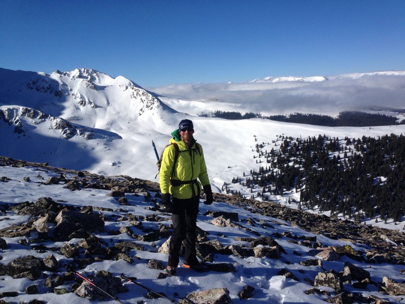
The views from here (~12800) were extraordinary. The fog layer continued falling away beneath us, with Sawatch 14ers poking out above it to the south. The weather up above the clouds was excellent: a nice gust here and there but nothing crazy.
A few more feet of gain above the talus pile and the ridgeline stretches before you.
The reason we hiked up here. The next ~1000' is pure enjoyment.
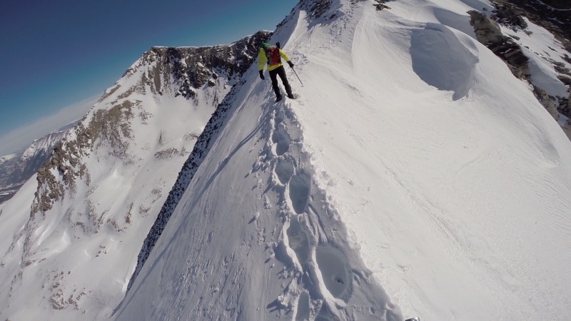
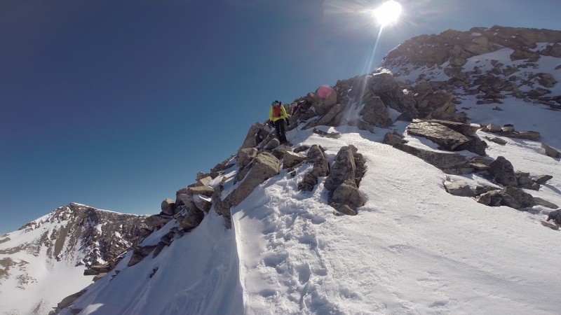
We stayed directly on the ridge the entire way to the summit. Every few hundred feet we would come to some type of obstacle, including blocks of talus, steep snow drifts, a cornice, a knife edge, etc. It was essentially an obstacle course situated on a 3-4ft wide balance-beam a mile long. Some highlights...
The "Hilary Step"
Knife Edge
Nearing the Summit
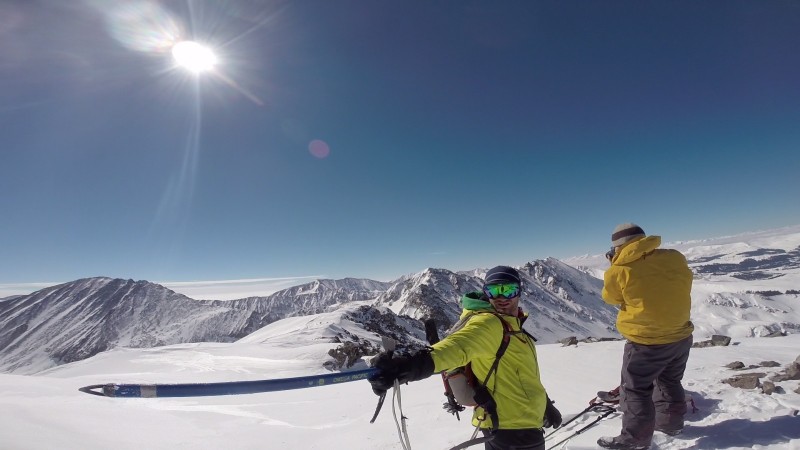
We reached the summit around 1130am, making for an ascent of just shy of 5 hours. One other person who we talked to in the parking lot the evening before raced past us just before we reached the summit. He wasn't jogging up, but he might as well have been. It was great timing for some mandatory summit pics.
Summit
On my last climb with Nathan, I caught an incredible model-pose at the base of the Angel of Shavano by chance, and this day the trend continued. Is he pointing to a skiable line on Pacific, or stretching his axe-arm for the camera? Actually, he looks like a transformer preparing to fire his arm-axe-cannon.
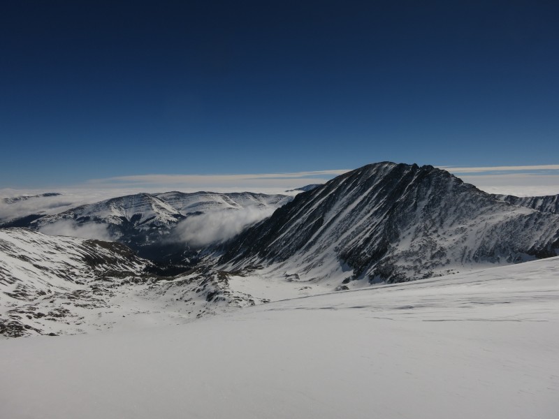
North Face Of Quandary Peak
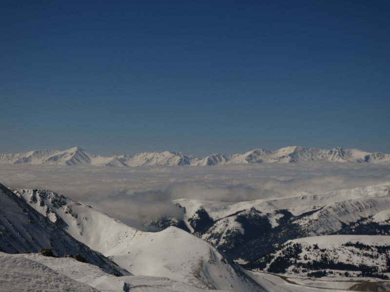
Sawatch Views
Gore Views
Elk Views
The descent was as enjoyable as the ascent, with slightly more slippery snow. We plunge-stepped where possible, but I fell several times working down the ridgeline. The self-belay stance of the ice-axe kept any slides from becoming too serious.
Descending Past the Cornice
The Cornice
Retracing the Knife Edge
Incredible route on an incredible day
We made quick work down the ridgeline, getting back to our snowshoes around 1230. The sketchy slope from the morning was wet, but only the upper few inches. We quickly followed the trench down and made it into treeline, where the postholing began. It took two hours to get from here back to the trailhead, as even when staying with the trench, every few feet registered a crotch-deep submergence. The usual barrage of swearing took over, and made us a feel a little better even if it didn't speed up the descent. We eventually began "skinning" with our snowshoes, not lifting our feet up but sliding them along the snow-surfce, keeping weight spread across both feet as much as possible. This slowed us down considerably, but worked to limit the postholing as we got lower and into warmer snow.
Arriving back at the TH at 230, my GPS read 7.4 miles round trip, in a little under eight hours. Having only climbed ten 14ers, I see no reason to wait to finish them before moving to explore the high 13ers. I didn't envy the little blobs of people we saw on Quandary's summit.
Thumbnails for uploaded photos (click to open slideshow):
You don't happen to still have the GPS track? We will try to do that route tomorrow and I can't find GPS tracks anywhere for the route starting at the winter TH...
Caution: The information contained in this report may not be accurate and should not be the only resource used in preparation for your climb. Failure to have the necessary experience, physical conditioning, supplies or equipment can result in injury or death. 14ers.com and the author(s) of this report provide no warranties, either express or implied, that the information provided is accurate or reliable. By using the information provided, you agree to indemnify and hold harmless 14ers.com and the report author(s) with respect to any claims and demands against them, including any attorney fees and expenses. Please read the 14ers.com Safety and Disclaimer pages for more information.
Please respect private property: 14ers.com supports the rights of private landowners to determine how and by whom their land will be used. In Colorado, it is your responsibility to determine if land is private and to obtain the appropriate permission before entering the property.


")
")
")
")
")
")
")
")
")
")
")
")
")
")
 The")
 Knife Edge")
 Nearing the Summit")
 Summit")
")
")
")
 North Face Of Quandary Peak")
 Sawatch Views")
 Gore Views")
 Elk Views")
 Descending Past the Cornice")
 The Cornice")
 Retracing the Knife Edge")
 Incredible route on an incredible day")
 view from the TH of the West Ridge")


