Download Agreement, Release, and Acknowledgement of Risk:
You (the person requesting this file download) fully understand mountain climbing ("Activity") involves risks and dangers of serious bodily injury, including permanent disability, paralysis, and death ("Risks") and you fully accept and assume all such risks and all responsibility for losses, costs, and damages you incur as a result of your participation in this Activity.
You acknowledge that information in the file you have chosen to download may not be accurate and may contain errors. You agree to assume all risks when using this information and agree to release and discharge 14ers.com, 14ers Inc. and the author(s) of such information (collectively, the "Released Parties").
You hereby discharge the Released Parties from all damages, actions, claims and liabilities of any nature, specifically including, but not limited to, damages, actions, claims and liabilities arising from or related to the negligence of the Released Parties. You further agree to indemnify, hold harmless and defend 14ers.com, 14ers Inc. and each of the other Released Parties from and against any loss, damage, liability and expense, including costs and attorney fees, incurred by 14ers.com, 14ers Inc. or any of the other Released Parties as a result of you using information provided on the 14ers.com or 14ers Inc. websites.
You have read this agreement, fully understand its terms and intend it to be a complete and unconditional release of all liability to the greatest extent allowed by law and agree that if any portion of this agreement is held to be invalid the balance, notwithstanding, shall continue in full force and effect.
By clicking "OK" you agree to these terms. If you DO NOT agree, click "Cancel"...
Type II Fun and Endurance Masochism; Columbia SE Ridge
I don't know a whole lot about avalanches. I attended an avalanche information seminar but have yet to take my AIARE I, so the extent of my knowledge is essentially: ridges are good, valleys not so much, avoid slopes between 30 and 50 degrees, and that more than 6 inches of fresh snow is extra scary.
I ended up hiking Quandary's East Ridge 3 times last year. So though it is commonly regarded as the closest thing to a "gimme" winter 14er, I was fairly sick of it and wanted to look into other options that weren't beyond my own avalanche knowledge. Hmmm...not many of those.
Except Columbia. Columbia's alternate route, this mountain wildly reviled for its' considerable skree and tedious hiking conditions, a half-marathon effort whether done with Harvard or without. I thought about it. I looked at TH accessibility. Read TRs, gathered beta. It sounded like a long haul. It sounded fun.
Our first attempt was on February 7th, near the end of the ridiculous dry-spell that brought most avalanche regions in the state down to green categorization. What a perfect day that could have been- partly cloudy but no predicted precipitation, shockingly little snow for that time of winter, a big enough group of people to have several potential paces. We turned around just about 12,000 feet due to wind gusts of 70+ miles per hour, consistent wind of around 40mph. It was still a beautiful day and a pleasant hike. Call it a practice run.
sunriseOne month later, 3 of us tried again. Shockingly sunny. Shockingly little wind. We started an hour earlier, just in case (5am) , and thank goodness we did. The snow below treeline was not particularly consolidated yet. This hike, given adequate time and appropriate weather, is a pretty wonderful winter hike insofar as being straightforward for determined parties. With enough snow, you also need decent navigation skills, especially during the 2/4 of the ascent. Navigation skills? But it's a ridge! But how hard could that be? Hard in the physical sense...if you let your feet follow the most gradual line, you traverse north on this very wide ridge. And north, of course, means more snow. Hang to the south side of the ridge, especially if you're not carrying a GPS. South enough to see where the side of the ridge grows steep, to have a path where the trees are thin and it's easy to see Yale all the time.
In winter or summer, I have two recommendations:
1) Take a full weekend. Hike close to the top of treeline and camp. Wake early, move to the summit, return, pack camp, and head back to your car. It's a beautiful hike with incredible views, and doing it this way will break up the loooooonnnnggg effort into something slightly more palatable.
2) Start in the middle of the night. Perhaps on a full moon. This should save you a good 6 hours of sunshine exposure, which especially in the winter can seem a bit oppressive. What a difficult choice it is- that constant reflection versus the wind or wet or cold.
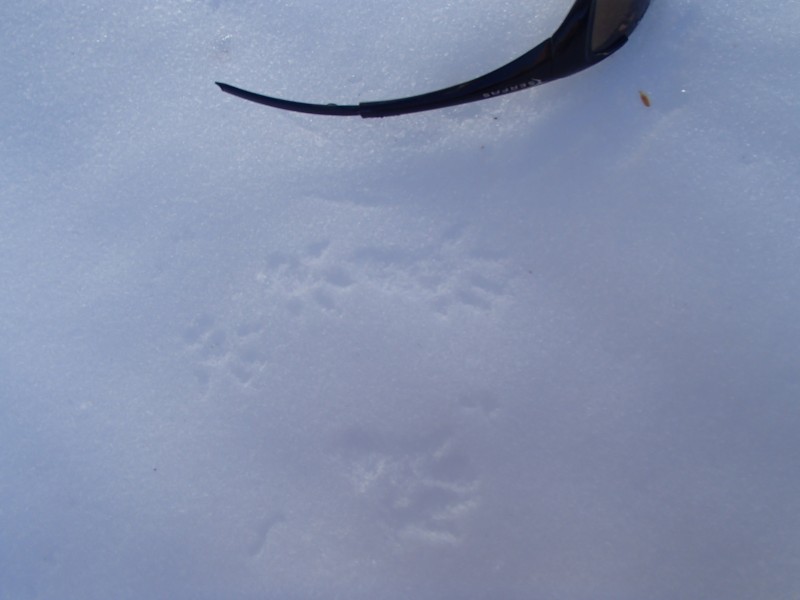
trackson trackson tracks
We started out slow. I wasn't feeling 100% and we wanted to be conservative. We were happily derailed by countless animal tracks: squirrel, rabbit, coyote, maybe fox, turkey, mountain lion, mice. We joked about continuing to Harvard. It wasn't until we got to around 12,000 feet that I started feeling antsy. I was deep into that psychophysical place of wanting to turn around but also badly wanting to see the world from 14,000 feet again, to fight my mental limitations.
Human pride is such an interesting thing. "I love the mountains," we say. "I want to do a winter peak," I'd thought for months, "I want to have this further, new experience and not just be a fair-weather summer mountain fan." And hiking mountains in winter is so much more difficult than in the summer, requires more logistics and deliberation. I can only imagine how much more difficult climbing mountains is in winter. Those mind-blowing, glorious pictures of people traversing Capitol's knife-edge in February, of sections of the Matterhorn. These feats that require more than just ambition or fondness for the outdoors, more than just endurance, but immense skill AND hard knowledge AND tenacity AND a bit of insanity. And the journey it took those individuals to get there, to develop that confidence in their hands and feet and minds, to polish their faith (in whatever they choose to name: themselves, the mountains, God).Nick with Princeton and Yale in the background
And yet for all those thoughts, they disappear in the flow. Those things vanish in the pure existence of throwing ones' body at the elements and testing its' limits. That's what we did, around 13,000 feet. Thinking about doubts and time and feeling unwell, I'd stopped again to wait for Katy and Nick after again getting carried away with finding the route, with following the cat and/or canine tracks leading ever upward, with seeing the actual peak, with discovering whether the animals lounging in the rockfields ahead were goats or sheep or elk (they were the latter). And we decided to split up and go our own paces. It was past noon. It reminded me of east coast hikes where a mile feels like an eternity, where 15 minutes can feel like an hour or a blink. elk on high
We went. I stopped briefly every 20 minutes or so to meet my needs: drink a little, eat a little, take a pee. Glance back along the ridge to see the black dots representing Katy and Nick. Harvard Upon reaching the summit, I looked along the route, that meandering ridge stretching out for miles to the southeast. Didn't dwell. Ate and drank a little. Snapped a few pictures. Laughed in admiration at the pika tracks in the snowed-in stone shelter. pika with great viewsAnd felt the way I only feel in the mountains. Pure and right and simple, where reward and consequence is tangible, where questions become less important for awhile. Began the trek down. Passed Nick and was rejoined by him about an hour later, just after sunset. a tea bag once read "empty yourself and let the universe fill you"
The Southeast Ridge of Columbia is wonderful. It is long, and painful, not standard...and that's okay. If you have high endurance and are developing your winter skills, I highly recommend it. It will push you more than Quandary, and is more solitary to boot. It was wonderful to plan and execute my own first winter ascent, to do so successfully. I did trash my immune system by hiking with the beginning of a cold, and paid for it. But it was a great start, and I look forward to learning from other mountain folk, developing more winter skills and communing with those people and these places. After all, that's what Type II fun is all about.day is done. hike is not.
Thumbnails for uploaded photos (click to open slideshow):
the selfies are on Facebook, duh. there would be more pictures here but my formatting skills are weak and I can’t figure out how to display vertically oriented pictures upright instead of sideways.
I know, right?? There’s another Columbia TR that would surely be overshadowed by this fine effort...if only pictures could be portrait–oriented. Maybe the Golden Surf could help me figure out my orientation issues.
There’s a great Columbia TR of a different route featuring you, Ben. Quite the legend: four ski descents of Columbia in one trip. And it’s been said that video is worth 1000 pictures.
:lol:
Anna, bring back fond memories. Congrats on completing the tough ridge!
Caution: The information contained in this report may not be accurate and should not be the only resource used in preparation for your climb. Failure to have the necessary experience, physical conditioning, supplies or equipment can result in injury or death. 14ers.com and the author(s) of this report provide no warranties, either express or implied, that the information provided is accurate or reliable. By using the information provided, you agree to indemnify and hold harmless 14ers.com and the report author(s) with respect to any claims and demands against them, including any attorney fees and expenses. Please read the 14ers.com Safety and Disclaimer pages for more information.
Please respect private property: 14ers.com supports the rights of private landowners to determine how and by whom their land will be used. In Colorado, it is your responsibility to determine if land is private and to obtain the appropriate permission before entering the property.
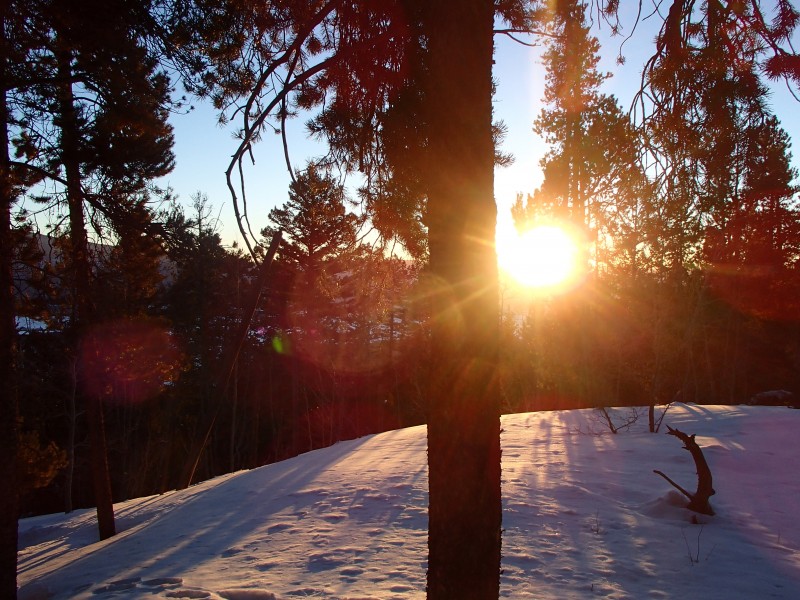


 sunrise")
 tracks")
 on tracks")
 on tracks")
 Nick with Princeton and Yale in the background")
 elk on high")
 Harvard")
 pika with great views")
 a tea bag once read")
 day is done. hike is not.")


