Trailhead: Aspen River Ranch
Mileage: ~18 miles
Elevation gain: ~5,900 ft
Dates: February 7-8, 2015
Ski crew: Mike, Jaaron, Natalie, Snowshoe crew: Jamie and Adam
Day 1 - the approach
Mileage ~4.5 miles
Elevation gain: ~ 1,300 ft
Time: ~3.5 hours
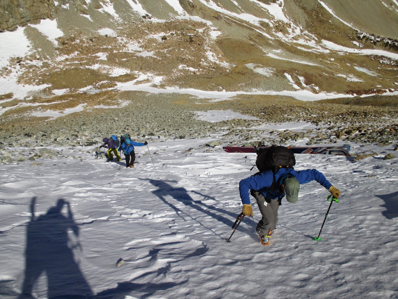
Mild weather presented another opportunity for winter camping in reasonable conditions. It also meant good road access. Jaaron and I got to the Aspen River ranch only to notice tire tracks continue further. After parking the Subaru and consolidating gear in Jaaron's truck, we were able to get a couple miles further in until we found Jamie and Adam's truck (they decided to show up an hour early to the meeting spot and didn't wait for us). Time to start skinning. Road remained almost dry for another couple miles, but then the snow levels gradually kept increasing. Even with snowshoer's trench we stopped making any meaningful progress. Jaaron soon found the root of the problem - glop! - in February. Thankfully, he brought the glop wax, which certainly helped a lot, and the progress resumed.


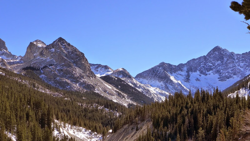
First view of the basin.
In about 3 hours we reached the summer TH only to find a note from Jamie saying that "skiers are slow". Well, it took them 4 hours, so not so sure who was slower  In another 15 minutes we reached the wide open meadow and set up the tent city. Jamie somehow lured me out of the tent for trailbreaking duties (which is called establishing a skin track in skier's parlance), but Jaaron just rolled his eyes and crawled into his sleeping bag for a nap (smart dude). So I had to glide in front of 'shoers in deep snow for about a mile only to watch them sink in behind me with every step. Satisfied with the effort, and in waning daylight, Jamie eventually allowed us to return to our tents. I think Adam mentioned something to the extent of getting skis for the next trip. In another 15 minutes we reached the wide open meadow and set up the tent city. Jamie somehow lured me out of the tent for trailbreaking duties (which is called establishing a skin track in skier's parlance), but Jaaron just rolled his eyes and crawled into his sleeping bag for a nap (smart dude). So I had to glide in front of 'shoers in deep snow for about a mile only to watch them sink in behind me with every step. Satisfied with the effort, and in waning daylight, Jamie eventually allowed us to return to our tents. I think Adam mentioned something to the extent of getting skis for the next trip.
Day 2 - summit day and ski/hike out
Mileage: ~13.5 miles
Elevation gain: ~4,600 ft
Time: between 11 and 13.5 hours

After a decent night of sleep, we left out of tents ready for the big day and got going around 6.45 am. I was hoping Mike, who was daytripping, would catch up to us and he did soon after we set out. Skiers took over the skin track duties.

Creek crossings were interesting as snow bridges kept melting

Skinning got a bit more challenging as we exited the forest and went up a rocky gully


MoneyMike skinning

Jamie higher in the basin

Skinning in the upper basin. Photo credit: Mike

Jaaron and Adam heading up the ridge. Photo credit: Mike
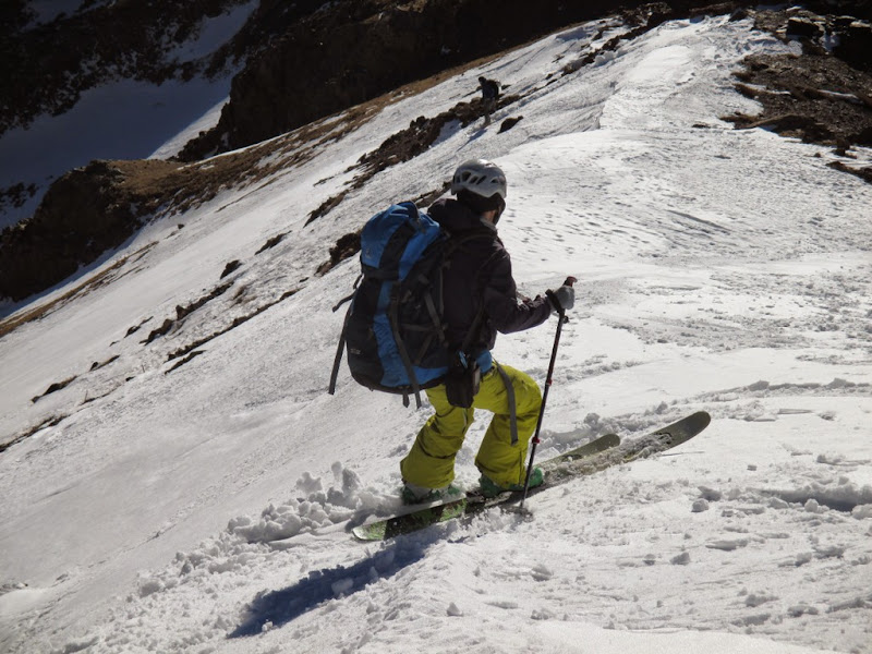
To our dismay, winds were pretty strong, although the forecast called for only 15 mph winds. At around 13k, skiers threw skis on the packs and booted up the ridge. Up to that point, everything went according to plan, more or less (except for the wind). From the saddle, the group split. Skiers decided to check the North couloir with Jamie going along, while Adam decided to go for the low hanging fruit - standard route. I went with skiers only to immediately question my decision. The day just went from "big" to "bigger" by my standards, with close to 900 ft of additional vertical and extra mileage. I was worried if I had enough energy not only to carry the skis to the summit, but to ski and then reclimb back to the saddle. I confided my concerns into Mike and ultimately decided to leave the skis at the bottom of the couloir.

Standard route

Traverse to the couloir (Photo credit - Jaaron)
Starting up the North couloir - Natalie, Jamie, Jaaron. Photo credit: Mike

Mike and Jaaron are stubborn (and awesome skiers), so they decided to go for it
About half-way up the couloir Mike figured out we were in the wrong branch of the couloir, which could potentially cliff out. Grrrreat! Never fear though, Jaaron found a good line across the rib and we soon joined forces with Mike who traversed to the "proper" couloir earlier.


Blanca from Lindsey

Mike looks happy to reach the summit with skis for the 2nd time

Natalie on the summit, ~1pm

Our fearless leader, Jaaron

Huerfano with Crestones in the distance
Weather was sweet - winds died down completely and we could spend some quality time on the summit enjoying the views. After everybody got their fill, we started down - Jamie went down the standard route following Adam's tracks who descended 1.5-2 hours earlier, while I headed down the North couloir, since my skis were stashed at the bottom of the couloir. I tried to move quickly as I thought skiers would zoom by me at any minute.

Rocky start which required some Davenporting

Entering the couloir

Conditions were pretty tough for skiing, but Jaaron somehow made it look good. Mike was right behind him.


Then there was an unpleasant part - reclimbing back to the saddle with Iron Nipple. It was getting pretty late in the day too - we gained the saddle around 3pm. From there it was downhill (mostly). We were able to make a few fun corn turns off the saddle, but for the next 4k of descent the snow was the mixture of sastrugi, breakable crust, powder in very thick trees, ice and other types of nearly unskiable terrain.


Corn turns off the saddle - Jaaron
Corn turns off the saddle - Natalie

Corn turns off the saddle - Mike

On the ski out

On the ski out.
Skiers got to the camp around 5pm, packed the camp and skied out. I was the last one reaching the car at 8pm. It turned out to be 18-hour day for Mike as a day trip, and 12-13 hour day for the campers, except Adam, who managed a reasonable 11 hour day via the standard route.
Trailhead: ~3 miles below summer TH
Mileage: ~15 miles
Elevation gain: ~5,500 ft
Date: May 23, 2015
Time: 12+ hours
Ski crew: Mike M, Jill, Frank and Dan
I didn't get to ski Lindsey in winter, so naturally, I had to go back to ski the peak. We picked a great weekend, with lots of snow in the Sangres in the prior week. A lingering snowdrift blocked a road a few miles below the summer TH, so we didn't get as far as we hoped. Mike and I launched around 4.30 with Jill's group a few minutes earlier.

Spring look of our winter campsite

Mike and Jill at the creek crossing
The route still being fresh in my mind, we didn't have any route finding challenges this time. After lots of steep skinning, we had Iron Nipple in sight.

Group skinning towards Iron Nipple

Mike M on the ridge to the saddle with Iron Nipple

Mt. Lindsey is looking a-la Mt. Everest
The weather didn't look promising and we struggled with the typical moody spring weather throughout the morning to about 9am, when the skies suddenly cleared.

As we approached the saddle, the weather started to clear out

It suddenly got really hot


Jill's group coming up

More steep traversing and climbing

Weather was starting to look a little threatening again
After quickly tagging the summit and making a transition, I was excited to drop in.

Summit

I had this to look forward to

Ski down was very enjoyable in good powder conditions

Huerfano

I skied all the way down to the valley floor and then waited for the group to catch up

We regrouped, transitioned back to skinning/hiking and made a painful climb back up to the saddle

Mike catching some bonus turns

Natalie
Of course, down low we had to deal with creek crossings and then hike out many miles back to the car, where Mike and I arrived around 5pm.

My GPS Tracks on Google Maps (made from a .GPX file upload):
|