Download Agreement, Release, and Acknowledgement of Risk:
You (the person requesting this file download) fully understand mountain climbing ("Activity") involves risks and dangers of serious bodily injury, including permanent disability, paralysis, and death ("Risks") and you fully accept and assume all such risks and all responsibility for losses, costs, and damages you incur as a result of your participation in this Activity.
You acknowledge that information in the file you have chosen to download may not be accurate and may contain errors. You agree to assume all risks when using this information and agree to release and discharge 14ers.com, 14ers Inc. and the author(s) of such information (collectively, the "Released Parties").
You hereby discharge the Released Parties from all damages, actions, claims and liabilities of any nature, specifically including, but not limited to, damages, actions, claims and liabilities arising from or related to the negligence of the Released Parties. You further agree to indemnify, hold harmless and defend 14ers.com, 14ers Inc. and each of the other Released Parties from and against any loss, damage, liability and expense, including costs and attorney fees, incurred by 14ers.com, 14ers Inc. or any of the other Released Parties as a result of you using information provided on the 14ers.com or 14ers Inc. websites.
You have read this agreement, fully understand its terms and intend it to be a complete and unconditional release of all liability to the greatest extent allowed by law and agree that if any portion of this agreement is held to be invalid the balance, notwithstanding, shall continue in full force and effect.
By clicking "OK" you agree to these terms. If you DO NOT agree, click "Cancel"...
Longs Peak Rangers Station (9,405')
Ascent: East Slope of Mt Lady Washington
Descent: Camel route to Chasm Lake
Elevation Gain: 4,000'
Distance: 8.5 miles
Climbers: MtnHub
Introduction:
To celebrate my retirement earlier this past summer, I spent several weeks hiking and climbing in the marvelous Colorado mountains. Weather and other complications prevented me from hitting most of what I originally had planned, but I still enjoyed a great trip and met with some new, as well as some old, friends during my stay.
During my last weekend in CO on September 13 & 14 I did two repeat climbs -- Mt. Massive and La Plata Peak. I planned to drive down from Leadville that Monday and stay with some relatives in the Denver area. I needed to turn in my rental car on Wednesday plus I had several other errands to take care of before my flight back home on Thursday, so Tuesday was really the only feasible day left for me to get in one last climb. But because of my tight schedule, I really had ruled out anymore climbing in my mind before I returned home.
For the last several years I've made climbing Longs Peak an annual event. But even with my generous allotment of time I never got it done this year. During much of the summer, Longs was deemed a technical climb because of persisting ice and snow in the critical areas. Since it was supposed to be a decent day on Tuesday, I thought that if Longs was melted out and doable, I'd make the attempt, but if not, I'd be content with what I had already accomplished.
I checked with the backcountry rangers before I left Leadville on Monday and they cautioned that it was still a technical climb. This was a big disappointment for me as I love that climb, but I also felt pretty exhausted having just done two 14ers in two days. So I just looked forward to relaxing for a few days and visiting with some of the nearby family before I headed home.
Not being a big fan of Interstate driving and Denver traffic, I exited I-70 at Highway 40 and drove up to RMNP. It was a beautiful sunny day and the trees were turning more all the time, so I decided to take a leisurely, more scenic drive through the Park and spend a little time in Estes Park before going on to my destination.
I also drove down to Glen Haven and had one of their famous cinnamon rolls for lunch, another annual tradition. The view of the mountain skyline coming back up to Estes Park along Devil's Gulch Road is one that I always love! If I'd ever win the lottery, this is where I'd want to live. I'd build a home along here so I could wake up to this sight every day. The beautiful view of the Meeker/Longs skyline from Devil's Gulch Road.
And as I was driving, absorbing this magnificent view once more, the mountain seemed to beckon to my heart. I just had to get on that trail once more even if I couldn't continue all the way up to the summit. I told myself I'd go as far as I could and just make a shorter day of it. So I vowed that if I could find a reasonably priced place to stay, I'd make one last attempt of it to cap off my trip.
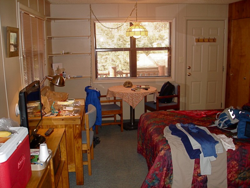
Well, finding a place to stay at all was more difficult than I expected. I was thinking I would have my pick of the lodging now that it was well after Labor Day, but evidently the fall foliage also brings in a lot of visitors. Nearly all the motels and resorts had their flashing "No Vacancy" signs out front. When I found a place with one small cabin still available, it was too rich for me to justify staying one short night. They recommended another place along Fall River Road, the Castle Mountain Lodge. I called them and they had a room for a good price right next to the office.
I drove right over to take a look at it. The room was great, very clean, and the hosts were super nice, so I immediately took it! And I got all excited about staying the night and climbing the next morning! I highly recommend them!
After checking into my room and unpacking, I went into town and brought back something to have for supper. Then I had a very relaxing evening watching an old Bogart/Bacall movie on TV while preparing for my final climb.
The Climb:
Despite the very comfortable room, I didn't sleep especially well, so I rise at 0430 and get ready to leave. I load up the car, drop the key off, and am heading south on Highway 7 in good time. Just a few miles before I reach the Longs Peak Road, I see a bull elk walking towards me on my side of the pavement. I have to swerve to the other lane to avoid him, and it startles me for a second.
There are quite a few vehicles already there when I arrive at the parking lot but I still find the very first space available directly in front of the Ranger Station. I've gotten this spot a lot in past trips too. But everything is quiet and I see no one else around. I walk over to the restrooms. The door is locked! This surprises me as the lights are on inside the building. So I go back to the car, gather up my gear, and head over to the sign-in booth. Again, it is locked and the light is off. They are evidently closed for the season!?
So I just start up the trail. It is about 0525 and very breezy but it's actually pretty mild, around 45-50 degrees. I love this trail! And I don't regret my decision to try it today even if it's only a partial climb. But as I walk along the pathway I debate in my mind whether I really want to go beyond the Keyhole. Depending upon the conditions I find and how soon I come across ice which may force me to turn around, it might make the day rather long. I also consider attempting Mt. Meeker via the Iron Gates instead, but this would also make for a pretty long day. With all the things I still need to do, I don't want to reach Denver too late.
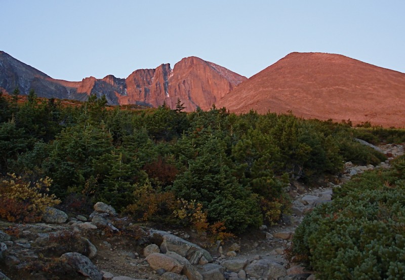
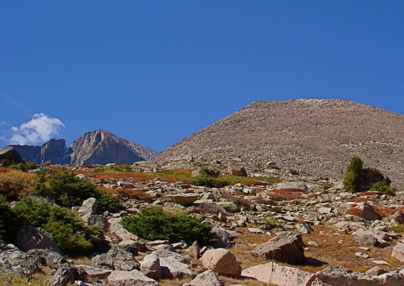
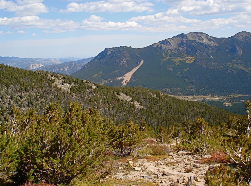
I turn these thoughts over in my mind as I cross the log bridge over Alpine Brook. The trail continues up through the subalpine firs and I get my first view of Longs in alpenglow. Longs Peak & Mt Lady Washington in the dawn's early light.
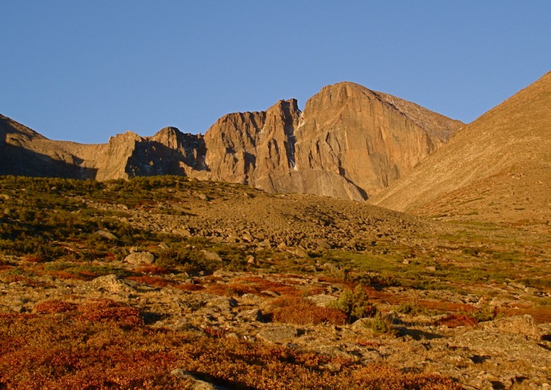
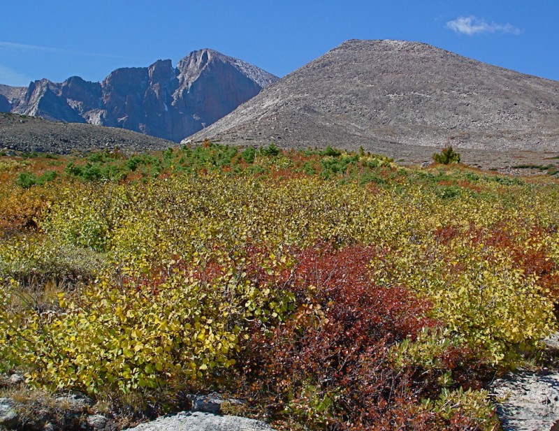
But now that there's nothing to break it's course, the wind hits me hard again. In all my visits to Colorado, I've never experienced such intense, sustained wind as I've had these past couple of weeks. I estimate it to be at least 30-40 mph as it impedes my walking significantly. Leaning forward into the stiff gale, I pursue onward up to Chasm Junction. The alpine vegetation is now clothed in its autumn reds and browns which is made even more intense by the early sunlight. Longs in September.
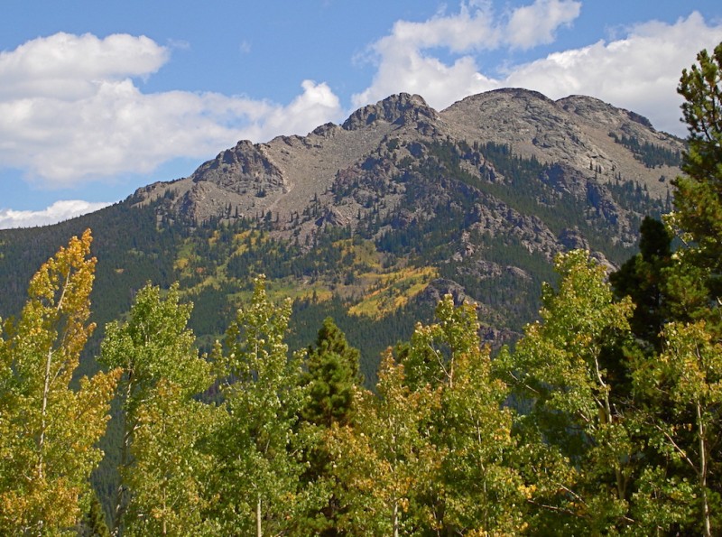
But as I keep walking and gazing at the changing color on the Diamond's face my focus turns to its close neighbor, Mt. Lady Washington. It only looks like a huge hill from this direction, really not very impressive, but I've never done it before. I've read in other reports that the views from its summit are really quite nice. Climbing it would also make for a much shorter day and I would probably be back to the car by early afternoon.
Then I also remember my last climb up Longs where I intended to go up the Kneeling Camel route and my partner and I missed it and took another much more difficult route to the Boulder Field by mistake. If I go up Lady Washington today I could descend the Camel gully and become more familiar with it for possible future ascents. The more I think about this, the more this little mini-loop appeals to me. Longs Peak with Mt Lady Washington.
I stop briefly at the Chasm trail junction. Looking over my options for the easiest access to the eastern slope, I continue along the main trail leading to Granite Pass just long enough to bypass a patch of thick brush. Then I turn and start up the side of Mt. Lady Washington.
The terrain is mostly good and stable rock among tufts of grass but the wind continues to be my worst obstacle. It is relentless in trying to push me off rock and off route, and I curse it under my breath (and sometimes even out loud!). I have all my layers on again and put hand warmers inside my mittens again which help, but if I were just standing still instead of climbing steadily, I would easily get chilled. When I get about halfway up the slope, I notice one lone hiker coming up the Longs Peak trail, the only other person I've seen thus far today. He is also struggling against the strong wind.
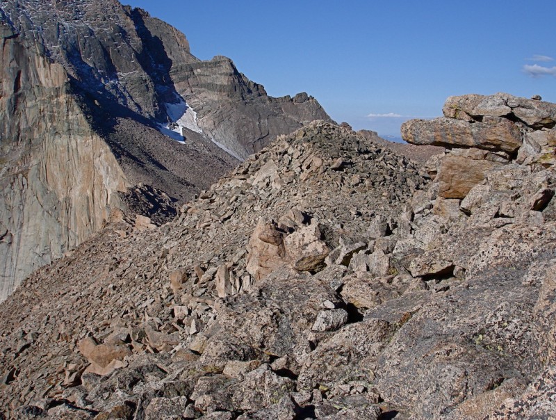
Fortunately, by the time I near the summit the wind tapers off to just a strong breeze, but it still doesn't make for a very enjoyable stay at the top. The view towards Longs Peak and Mt. Meeker across the way are pretty amazing however. I manage to take a few shots in various directions before quickly putting my mittens back on to keep my hands from freezing up. The magnificent Diamond from Martha's summit.
Mt. Meeker from Lady Washington.
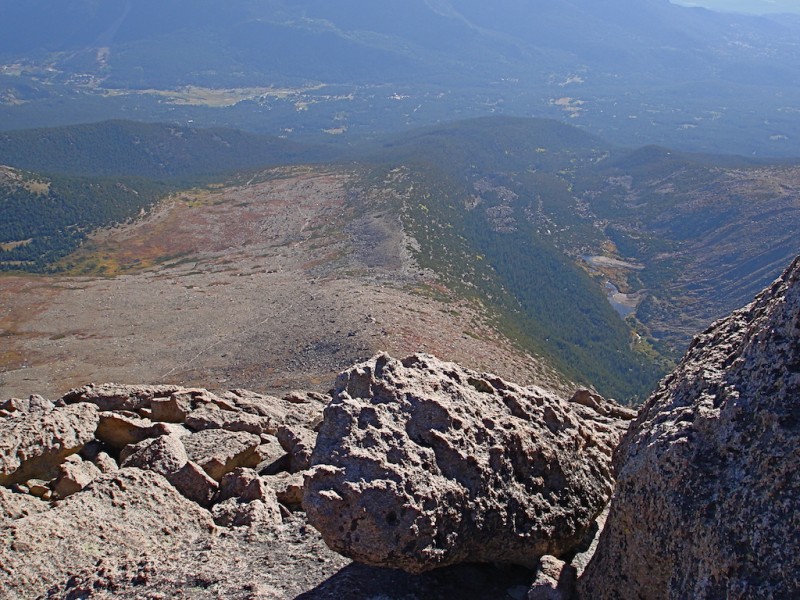
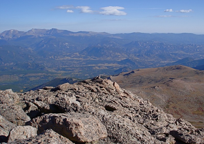
From Mt Lady Washington's summit: looking east down Mills Moraine.
From Mt Lady Washington's summit: looking north to the Mummy Range.
As I survey the southwestern ridge, I see what I think must be the Kneeling Camel, the rock feature marking the correct gully down to Chasm Lake. Looking down the southwestern ridge, the Kneeling Camel can be seen at the low point.
I begin my descent along the rocky ridge and when I near the lowest point of the ridge I do recognize the rock feature as indeed the Kneeling Camel. Here, I look over the mouth of the gully for the best possible route down into the boulders. The Kneeling Camel Rock (right center) marking the descent.
The rocks and boulders are all pretty stable so it really doesn't matter too much how you go. The Kneeling Camel. Looking up from the top of the gullly.
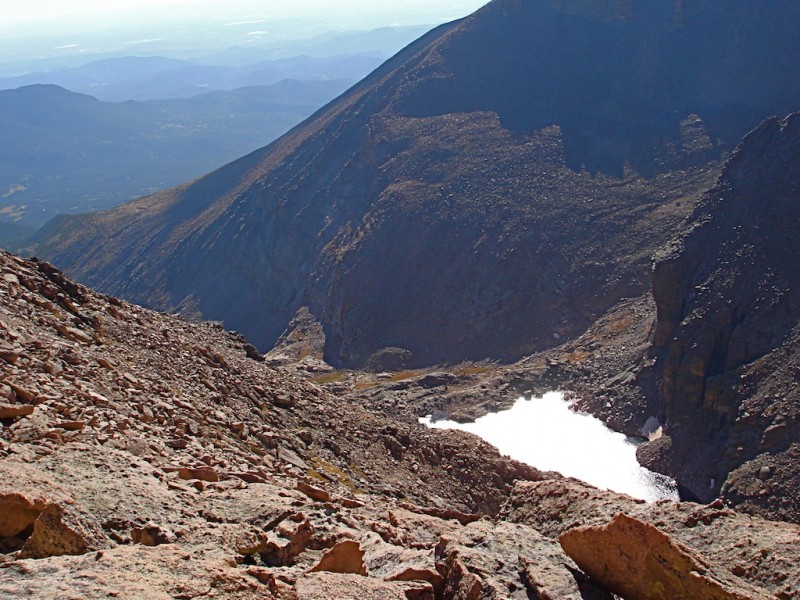
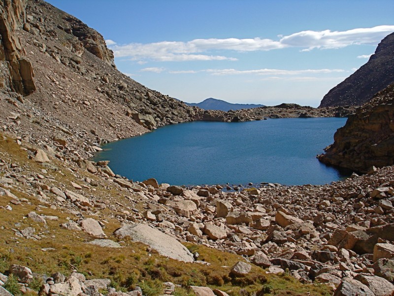
The gully eventually funnels and then narrows at a point where it doglegs to the right and angles down into the basin. Chasm Lake becomes visible on my left. Chasm Lake, coming down the Camel route.
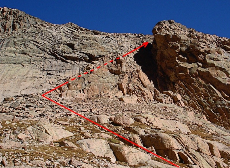
The rocks and scree are a little looser the lower you go but it really isn't too difficult. You descend along the base of a sheer cliff face on your right, so if you want to ascend this way, look for this cliff to identify the route. If ascending, look for this sheer cliff face.
A little lower down, I noticed another unique protruding rock feature that identifies the gully entrance, and I make note of this for a future trip. Another identifying rock feature marking the gully entrance.
Near the base of the gully, you will also pass through several large boulders that almost seem like entrance gates. You are very near the level of Chasm Lake at this point. There are large boulders to pass between near the entrance.
I rock-hop over to the trail around the lake. Chasm Lake.
The trail around Chasm Lake.
There are now a few other hikers enjoying a visit on the eastern shore. The Iron Gates of Meeker in the shadows.
Longs Peak towering above Chasm Lake.
I don't linger at Chasm Lake but immediately start climbing down to the trail below. The trail down from Chasm Lake and up to the trail junction. Twin Sisters in the background.
The trail rises slightly up to the junction where it joins the Longs Peak trail and you get some excellent views of Columbine Falls and Peacock Pool. Columbine Falls.
Peacock Pool.
There are three llamas tethered to the hitching post at the junction. They carry various supplies for the park rangers doing maintenance work. While I've come across them several times in previous years, I still get a kick out of seeing llamas in the Park. It makes me think I've made a wrong turn somewhere and I've somehow crossed into Peru. Take me to your llama (Chasm Lake Trail junction).
I soak in the rich earthy colors the changing weather has brought out in nature. It is a different scene than what I normally see when hiking in midsummer. I'm glad to be able to witness it on this trip. Mt. Lady Washington with the top of Longs' Diamond.
Jim's Grove.
The trail junction below Pine Ridge.
Fall colors with Longs Peak & Mt. Lady Washington.
Just before the trail drops down into the forest, I can see the massive scar the 2013 landslide left on the side of Twin Sisters across the valley. The slide area (2013) on Twin Sisters.
I cruise down the rest of the trail and reach the parking lot before I know it. It's only 12:30 so I have plenty of time to drive to Denver and still get some errands done. This climb was the culmination of a wonderful vacation and I feel richly blessed! View from the Longs Peak Ranger Station.
Thumbnails for uploaded photos (click to open slideshow):
... great pics. Wish I'd thought of going down the route you did when I did MLW. Guess I'll have to go back and do that one again. Also - you are now my hero - RETIRED!!! Yes! Hopefully, I will be doing that soon as well!
Nice report, pics, and good info 10/28/2014 7:34pm
That does sound like a nice loop. Makes MLW look like a much more interesting hike than just up and down from the boulder field. I like the fact that you weren't completely sure what you would do at the beginning of the hike and just kind of rolled with it. Well done.
@ mathguy: I used to be much more ”spontaneous” in my climbing in the past, and although this last climb was kind of that way, it is not how I normally do things anymore. There are several excellent threads in the forum regarding how important and wise it is to give someone ALL the details of where you are going -- estimated starting time, exact route you're taking, TH info, Sheriff phone numbers, etc. If things go wrong and you find yourself in trouble, a rescue is very difficult, and maybe impossible, if no one knows where you are.
Although I did do MLW on a last minute decision, my wife did know roughly where I was (Longs Peak Ranger Station and trail). I was very familiar with the area and all the trails around there and I knew what I would find, so I did take a slight chance by not contacting her with updated information (I couldn't get adequate cell service to reach her). Although it was a fairly low risk, it was still a risk, and one I will normally not take at all if it can be avoided. Climb on, but climb safe! :D
Too much spontaneity when hiking is definitely not a good thing (especially when hiking solo), unless go the Delorme route (or something similar) so you can keep others informed of your plans.
Sorry we couldn't connect this year, Doug. Pesky floods... I am back home now but plenty of work left to do. This is the 1st of your reports this year that I've been able to read but I'll try to get to the others at some point. I'll have to give the camel a go sometime. I really wasn't sure where that route was, so this helps. Got some nice pics too.
The peak certainly isn't much to look at, but that isn't the true reward is it? One of these days I'll have to take the camel route, so it was good to see it through your photos. Anything to avoid the 10 miles of switchbacks!
Yeah Gary, I missed hiking with you again this year too! Glad to hear the house is getting back to normal, albeit slowly. We definitely need to connect on something next year however!
O. – I agree the views from MLW are pretty phenomenal! The Diamond is simply right in your face, and the serrated ridges coming off of Meeker offer an amazing perspective of that mountain. I also think looking down the SW ridge towards the Camel rock is pretty neat too!
"Anything to avoid the 10 miles of switchbacks!" –– Ha! :lol:
I actually never really minded those switchbacks, but the Camel route really is a lot more fun! Thanks for your comments! :D
Glad you got to revisit your old friend in a different way. Photos 11 and 12 are spectacular! (And yes, I noticed "Martha" – very clever.) Good service in putting up that Camel Route info too; that should help others interested in that variation.
Caution: The information contained in this report may not be accurate and should not be the only resource used in preparation for your climb. Failure to have the necessary experience, physical conditioning, supplies or equipment can result in injury or death. 14ers.com and the author(s) of this report provide no warranties, either express or implied, that the information provided is accurate or reliable. By using the information provided, you agree to indemnify and hold harmless 14ers.com and the report author(s) with respect to any claims and demands against them, including any attorney fees and expenses. Please read the 14ers.com Safety and Disclaimer pages for more information.
Please respect private property: 14ers.com supports the rights of private landowners to determine how and by whom their land will be used. In Colorado, it is your responsibility to determine if land is private and to obtain the appropriate permission before entering the property.