Download Agreement, Release, and Acknowledgement of Risk:
You (the person requesting this file download) fully understand mountain climbing ("Activity") involves risks and dangers of serious bodily injury, including permanent disability, paralysis, and death ("Risks") and you fully accept and assume all such risks and all responsibility for losses, costs, and damages you incur as a result of your participation in this Activity.
You acknowledge that information in the file you have chosen to download may not be accurate and may contain errors. You agree to assume all risks when using this information and agree to release and discharge 14ers.com, 14ers Inc. and the author(s) of such information (collectively, the "Released Parties").
You hereby discharge the Released Parties from all damages, actions, claims and liabilities of any nature, specifically including, but not limited to, damages, actions, claims and liabilities arising from or related to the negligence of the Released Parties. You further agree to indemnify, hold harmless and defend 14ers.com, 14ers Inc. and each of the other Released Parties from and against any loss, damage, liability and expense, including costs and attorney fees, incurred by 14ers.com, 14ers Inc. or any of the other Released Parties as a result of you using information provided on the 14ers.com or 14ers Inc. websites.
You have read this agreement, fully understand its terms and intend it to be a complete and unconditional release of all liability to the greatest extent allowed by law and agree that if any portion of this agreement is held to be invalid the balance, notwithstanding, shall continue in full force and effect.
By clicking "OK" you agree to these terms. If you DO NOT agree, click "Cancel"...
In the lead up to the weekend, NOAA called for a 60% chance of storms beginning around noon. The practiced summer climber in Colorado knows that a forecast like that means (generally) that a morning climb is feasible, but care must be taken to evaluate the skies throughout the day.
Ryan and Tony had discussed this trip prior and graciously extended me an invitation to join them in attempting Mt. Wilson and El Diente via Kilpacker Basin. The clever route up to Mt. Wilson at the end of the rugged basin intrigued me, and I accepted the invitation readily. We kept a wary eye on the forecast as we prepared for the weekend, and decided on Friday that, given that Tony and I had already elected to cancel this trip in mid-July due to weather, we ought to head down, start early, and give it a try. The worst that could happen was that we would be turned around, right?
We loaded up the car in Morrison and left around nine on Saturday morning, and began the long trek to the San Miguels. Upon stopping for gas and lunch in Montrose, I decided to check the weather for the next day, noting hopefully that the afternoon storms forecast for that day had yet to materialize by early afternoon.
80% Chance of Heavy Rain after 10 AM
Great. Had I seen this forecast in Denver, I'd have stayed home. We were already five hours into the drive, so we decided to head up to our planned high camp in Kilpacker Basin anyway. If it rained - well - at least we could say we tried. No reason to run back to Denver with our tail between our legs as long as we played it conservatively the next day.
An hour and a half later, we had passed Telluride and were getting poured on while looking up mournfully at the Wilsons, bedecked in clouds, as we got ever closer to a sure soaking at the trailhead.
We pulled up to the trailhead, got out of the car, and the rain stopped. Just a short shower.
We blazed up the Kilpacker trail and established camp in a shaded copse of trees just off of the trail and near a stream. Nearby was a gorgeous view of a waterfall, framed by trees and presided over by the brooding summit of El Diente, currently cloaked in clouds.
After setting up camp, he headed a hundred yards up the creek to the waterfall to take pictures - this was one of the prettiest places I've been.
Not a bad place to camp. Unfortunately, it was overcast or this picture would've been truly spectacular.
As light began to fall, we scarfed down some mountain house - Chicken teriyaki and rice is awesome - and got in bed, setting our alarms for 2:50.
We were on the trail by 3:25, and immediately gained elevation steeply up short switchbacks through the trees. The trail soon flattened out and headed into bushes and willows.
We got a bit off route here - you will come to a small cairn in the trail with willows behind it to the right and a much less defined trail heading up and to the left. Do not go this way. The correct trail is actually to the right behind the cairn (seemingly into the willows) and it drops slightly and parallels the creek. We did not realize this until the way down and lost several minutes wandering up and down the willow-riddled hill looking for the trail which we eventually found in the subsequent talus field.
Upon finding the trail again, it does exactly what you would expect to 12,600 feet: Stays well marked and gains elevation consistently.
Follow the cairned (and well-defined) trail to 12,600. We arrived at this spot around 4:45, and knew it was time for GPS guidance. We left the trail which had turned up for el Diente and hiked the gently rising slopes up Kilpacker Basin towards Mt. Wilson, being careful to stay to the left of the bottom of the drainage.
Water rushed under the rocks in areas several feet beneath us, emitting a dull roar reminiscent of a heavy wind. Clouds had obscured the sky relegating the early morning darkness to impenetrable. The combination made for some eerie moments as this hour.
The plan was to head up the basin until about 13,000 feet where we would head left towards Mt. Wilson along the gentlest contour lines to an upper plateau around 13,600. From here, we would aim for the gully entrance described so well in previous trip reports. The caveat was that we would be doing most of this in the dark, relying on the GPS and maps we had printed to keep us on route.
To further complicate things, low clouds rolled into the basin, thick enough to make it look as if our headlamps were trying to cut through smoke, and essentially soaked the rock everywhere around us. I'd be fooling you if I told you we never thought we might have to turn around when dawn broke and revealed the gloomy conditions.
We were able to follow our plan pretty well, joking that we were following IFR (Instrument Flight Rules - an aeronautical term) for the ascent. We did travel a bit too far up the basin towards South Wilson, but realized our mistake quickly, and compensated by heading up an obnoxiously steep scree slope to reach easier ground around 13,400.
At this point, the sun began to rise and the clouds lifted, revealing the dramatic wall and rampart-like towers above us that marked the summit of Mt. Wilson.
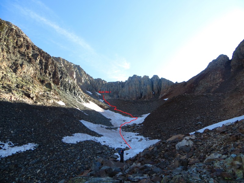
We climbed a few more scree and talus slopes on loose rock, avoiding the bulletproof snow, and made it to the last 100 feet before our entrance into the gullys.
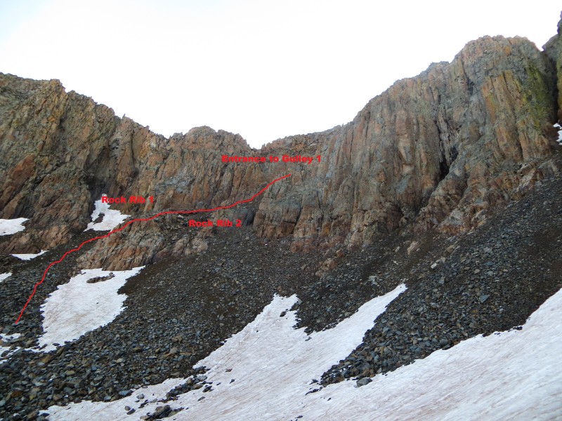
It's easier to draw a picture, so the route is outlined below. You essentially head up the talus slope taking care to avoid kicking rocks on your friends below you, make a few class three moves to cut through the first rock rib, traverse along the wall above it (where the dirt and rock is more stable), and pass another, minor rock rib (rock rib 2) to reach the first gully.
This picture shows the general route to enter the first gully. In general, stick as close to the solid cliffs as possible for
It was in this area that we made a shocking find. As I glanced down to evaluate where I could step, I noticed a rock that was reflecting the sky. Wait - rocks don't reflect - what is that?
I pulled out a slightly wet, mud-caked, but unscathed Droid Razr. As wet as things were, we doubted it would work, but decided to pack it out, and take it home to try to return it. Post-trip Ryan cleaned the phone up, plugged it in, and it lit right up. It had been dropped LAST August and survived an entire winter at 13,900 feet under the dramatic cliffs of Mt. Wilson's ridge!
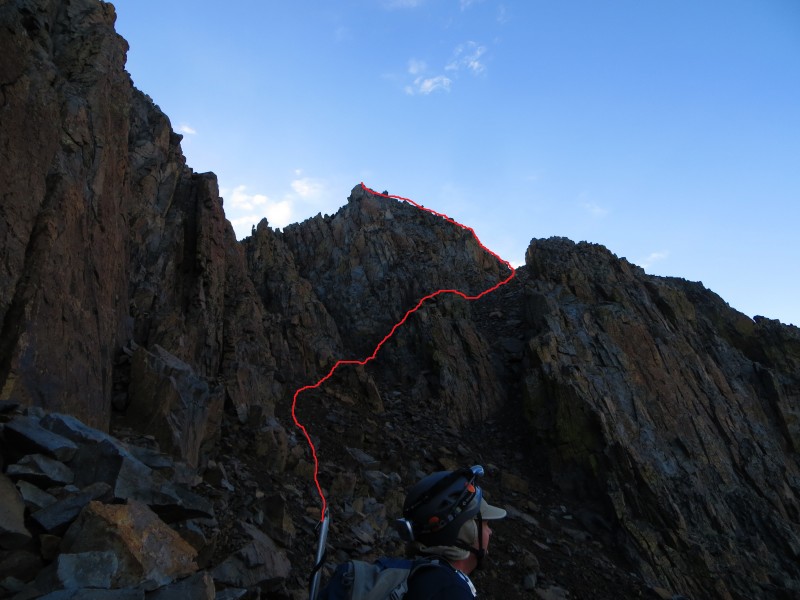
From here, you ascend only about twenty feet before taking an obvious exit over the rock rib to meet the second gully. The rock is loose and the ledges are gravel covered here, so while the route is between class 2+ and class 3, take care in this section. Upon reaching the second gully, follow the wall of the rock rib on the left where the rock and dirt is far more stable until you are just a few feet below the notch in the ridge signifying the top of the gully.
Thi spicture, apart from a lovely profile of Ryan, is great for determining the final route from Rock Rib 2.
Look up to your left and notice rubble-strewn, class 3 ledges that climb the last hundred feet to Mt. Wilson's summit. Care must be taken here to avoid kicking rocks down the route below you, but the climbing is quite fun.
The final pitch to Mt. Wilson (taken from the Summit)
One more class three move up a waist-high boulder deposits you on the summit, and you are immediately struck by the views around you. What a gorgeous place!
We took pictures and relaxed for a half hour, delightedly noting that the weather looked great (though it was only 7:15), and readied ourselves for the low traverse to El Diente.
The Traverse from Mt. Wilson
Lizard Head - backlit by sun and carpeted by clouds
Peaks in the Windom Group beyond a sea of clouds.
Gladstone, Sneffels, Clouds, and Rays of Sun
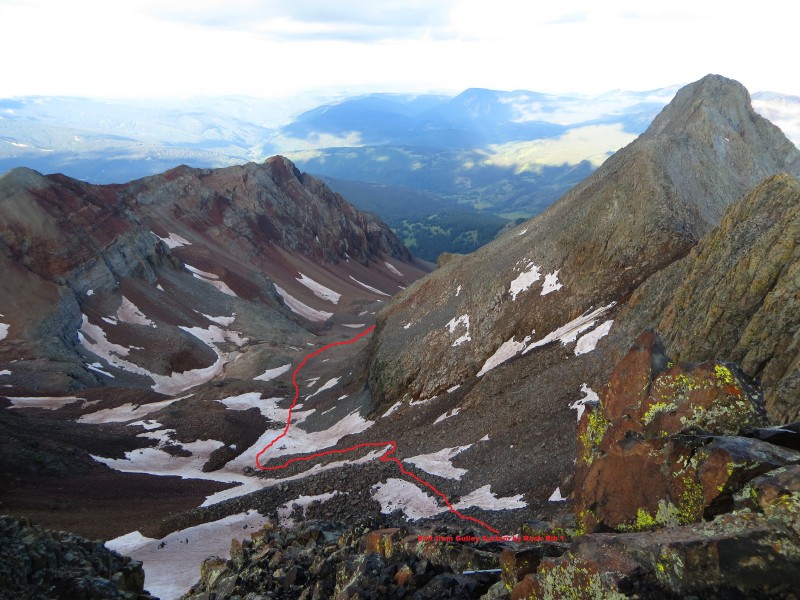
We dropped down the gullys and back into the high plateau around 13,700, and all agreed that the route had been loose, but far better than anticipated. We contoured left around a lump in the platuea and dropped to another flat area around 13,500, this time filled with snow. We noted a shallow, low-angle gully to our right and were thrilled to discover that our microspikes had excellent bite in the slightly softer snow. A careful drop down the gully (or where the snow ended in it) took us to an area with broken ledges that could easily be navigated at class 2. We quickly found ourselves at 13,100 (as recommended by previous TR authors who had noted that they had stayed too high) and began to head towards El Diente while losing as little elevation as possible.
A view of the descent route from Mt. Wilson. The red line begins where you exit the fist rock rib (from the ascent)
A look back at the descent route from around 13,300. Rock Rib 1 is labeled for reference
Evaluating the route, we decided to aim just below a rounded rock outcropping and then to maintain elevation to el Diente. I descended a bit too far at one point (down to 13k) but course-corrected before Ryan and Tony made the same mistake.
A look at the low traverse to El Diente from around 13.1k. The star marks where we joined the standard route up El Diente.
We navigated a cliff band up easy (though loose) talus, and found ourselves right on the cairned route up to El Diente a hundred feet below the gray rock before the red rock rib. I was shocked at how far the route swings towards Mt. Wilson before ascending.
A look back on the traverse from the gray rock at 13,300 on El Diente. The shallow, snow-filled gully we walked down is hidde
I won't go into detail on the El Diente route as it is extremely well documented on this site other than to say that it was more challenging than the route up Mt. Wilson (though the rock on the approach from 13,200 was more stable).
Very close to the summit of El Diente
Looking over to Mt. Wilson
Wilson Peak fending off clouds.
Ryan headed down from the notch near El Diente's summit
We headed down the tedious, talus-composed trail, broke camp, and made it to the car without any worse than light rain on the pack out.
The long slog down.
God must have been smiling down on us, because no sooner had we reached the highway than a heavy rain struck and followed us intermittently for the entire drive back to Denver.
A few final thoughts on this route up Mt. Wilson with a complete disregard to any semblance of order:
- It's not too exposed
- It's not that loose once you enter the gully systems if you stick the solid rock and dirt along the sides of the gullys
- The gullys are steep but not as steep as we expected. They really weren't too bad.
- The rock from 13,300 to the entrance to the gullys around 13800 was far worse than the rock in the gully as long as you carefully select your route.
- If it wasn't a talus-fest, this would probably be the standard route on Mt. Wilson.
- The summit is tiny, exposed, and WOW does the standard crux look daunting from the summit!
You've got to do this climb.
~ Ameristrat
Thumbnails for uploaded photos (click to open slideshow):
Going to be doing this soon, and thanks for the detail going up Wilson from this side. This is the first report I've seen where Wilson was done before El Diente. Do you think there's any advantage to doing either one first?
We had a tough weather window and reasoned that, if we had to come back, El Diente would be easier to climb in a day.
I liked Wilson first just to get the talus slog out of the way early, but do not attempt it in the dark without a GPS, excellent compass and map skills, and a thorough plan for where you will go. The basin is disorienting in the dark (all talus, no real landmarks).
To answer your question directly, it's all about conditions. If you can see where you're going and weather is good, it probably doesn't matter which you do first.
I'll try to add our GPS track later on. Hopefully that will be helpful too.
Excellent write-up, Teddy! I'm still super glad it all ended up working out wonderfully.
Roald: For me, going for Wilson first was better mostly just because it is farther, and the climb up El Diente becomes part of the overall descent, in a way. Also, making a "go or no-go" decision on the 2nd peak with the weather is easier with El Diente than Wilson since El Diente is a shorter part of the trip than Wilson. Edit: Also, the above. ^
80% Chance of Heavy Rain after 10 AM 8/9/2014 2:20am
Way to go, guys! Although, I'm not sure any of you technically reached the summit without seeing a selfie on top. :cry:
In a few more years the backdoor on Wilson will become the standard route and once all the loose stuff gets kicked out, it's going to be a Class 2+ hike. You did a good job taking advantage of the opportunities that were presented during a small weather window. Congrats on two beautiful peaks!
I found Mt. Wilson's standard crux to be much more unnerving than anything on the 14ers other than Sunlights summit block. We never considered hitting it up the way you did...I wonder why? Good work. Good pics!
I can imagine that the std crux looks daunting from the top, if you hadn't climbed it. I went up the std route, and as I was going down, I kept thinking to myself, "now how did I do this move again?" And, I had gone up it. It would have been interesting if you had decided to try to go down it. Daunting for sure.
Enjoyed your write up! The low traverse certainly avoids the difficulties of the standard traverse. A friend and I would like to repeat the route and would really appreciate it if you post your GPS track.
Hopefully this will become the standard route. I'm climbing this weekend and may try it. Thanks for the detailed description and photos. Do you have a GPX file? Maybe Bill needs to add this to the route descriptions.
Caution: The information contained in this report may not be accurate and should not be the only resource used in preparation for your climb. Failure to have the necessary experience, physical conditioning, supplies or equipment can result in injury or death. 14ers.com and the author(s) of this report provide no warranties, either express or implied, that the information provided is accurate or reliable. By using the information provided, you agree to indemnify and hold harmless 14ers.com and the report author(s) with respect to any claims and demands against them, including any attorney fees and expenses. Please read the 14ers.com Safety and Disclaimer pages for more information.
Please respect private property: 14ers.com supports the rights of private landowners to determine how and by whom their land will be used. In Colorado, it is your responsibility to determine if land is private and to obtain the appropriate permission before entering the property.


 Not a bad place to camp. Unfortunately, it was overcast or this picture would've been truly spectacular.")
 Thi spicture, apart from a lovely profile of Ryan, is great for determining the final route from Rock Rib 2.")
 The final pitch to Mt. Wilson (taken from the Summit)")
 The Traverse from Mt. Wilson")
 Lizard Head - backlit by sun and carpeted by clouds")
 Peaks in the Windom Group beyond a sea of clouds.")
 Gladstone, Sneffels, Clouds, and Rays of Sun")
 A view of the descent route from Mt. Wilson. The red line begins where you exit the fist rock rib (from the ascent)")
 A look back at the descent route from around 13,300. Rock Rib 1 is labeled for reference")
 A look at the low traverse to El Diente from around 13.1k. The star marks where we joined the standard route up El Diente.")
 A look back on the traverse from the gray rock at 13,300 on El Diente. The shallow, snow-filled gully we walked down is hidde")
 Very close to the summit of El Diente")
 Looking over to Mt. Wilson")
 Wilson Peak fending off clouds.")
 Ryan headed down from the notch near El Diente's summit")
 The long slog down.")
 This picture shows the general route to enter the first gully. In general, stick as close to the solid cliffs as possible for")