Download Agreement, Release, and Acknowledgement of Risk:
You (the person requesting this file download) fully understand mountain climbing ("Activity") involves risks and dangers of serious bodily injury, including permanent disability, paralysis, and death ("Risks") and you fully accept and assume all such risks and all responsibility for losses, costs, and damages you incur as a result of your participation in this Activity.
You acknowledge that information in the file you have chosen to download may not be accurate and may contain errors. You agree to assume all risks when using this information and agree to release and discharge 14ers.com, 14ers Inc. and the author(s) of such information (collectively, the "Released Parties").
You hereby discharge the Released Parties from all damages, actions, claims and liabilities of any nature, specifically including, but not limited to, damages, actions, claims and liabilities arising from or related to the negligence of the Released Parties. You further agree to indemnify, hold harmless and defend 14ers.com, 14ers Inc. and each of the other Released Parties from and against any loss, damage, liability and expense, including costs and attorney fees, incurred by 14ers.com, 14ers Inc. or any of the other Released Parties as a result of you using information provided on the 14ers.com or 14ers Inc. websites.
You have read this agreement, fully understand its terms and intend it to be a complete and unconditional release of all liability to the greatest extent allowed by law and agree that if any portion of this agreement is held to be invalid the balance, notwithstanding, shall continue in full force and effect.
By clicking "OK" you agree to these terms. If you DO NOT agree, click "Cancel"...
| Niagara & Jones from Burns Gulch |
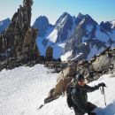
Jones 13,860' & Niagara 13,807' from Burns Gulch Tuesday July 1, 2014
Ian MountainHiker), Dorthe(MountainHikerette), climbing bear Snowball, Steve, Michelle & climbing Corgi Jazzy.
Evening sun hitting Jones & Niagara.

The first issue most will encounter is the Burns Gulch Road. If you have a sturdy 4WD you can start significantly higher than with a passenger car. From the Silverton side of the Cinnamon Pass road, Burns Gulch leaves the main road before actually turning up the pass. UTM 275154 4199799 10,853' NAD83/WGS84 The most direct access you'll see to this road would have you fording the Animas River. But a couple hundred meters upstream the main road crosses the Animas. You can then use the beginning of the Grouse Gulch road to access Burns Gulch road without having to ford the river. You'll still have to drive across the Grouse Gulch creek, but that shouldn't be a problem if your vehicle is capable of driving up the Burns Gulch road. The first part of the road is a narrow shelf where it's not fun to meet another vehicle.
We arrived before our friends Steve & Michelle, so we drove the Burns Gulch road first to reconnoiter. At about 1.5 miles and 11,600' I declared the road was getting too rough with loose rolling rocks. 276423 4197850 11626'. Plus, there weren't a lot of places to pull off. Just above this point, there was an old mine site on the left that would have worked for parking. If it had been just us, that's probably where we would have stayed. But Steve & Michelle were driving a Rainier with regular tires and running boards and I didn't want to re-drive the rougher stretch. On the way down we saw the spot we would camp at. There was a pull-out on each side. 275933 4198416 11,365' Higher up snow was blocking the road.
This spot is on the right side of the road heading up. It appeared to be an older version of the road now growing over.

Roach describes following the road to its highest point and then a trail to the pass. This is true, but for us the trail disappeared under snow in several places. Fortunately the trail did show itself for the section gaining the pass. As Roach points out, the trail gains the pass on the Jones side of the saddle.

We did Niagara first. Niagara has a trail leading up through the rocky area on the lower part of the ridge. We then encountered the snow. Our axes were back in the Jeep, and they would have been nice to have for this stretch. We did wear our MicroSpikes and use poles. Note, this snow wasn't apparent from the campsite! We were able to skirt much of the snow on the way down, but still had to cross it in a couple places. The route is much easier to see from above.
Niagara from the saddle

Snow higher on Niagara. We descended on the rock picture left, but still had to cross steep snow to get to it.

Dorthe arriving at summit of Niagara

From the saddle Jones has a fairly good trail to the summit. We crossed snow a couple times but it wasn't an issue. The summit push trail is perched on a lot of loose rock that would need some work to stand up to fourteener traffic.
Looking over at Jones from Niagara

Jones from Niagara

Looking back at Niagara from Jones

Dorthe arriving at summit of Jones

We had thoughts of doing American 13,806' next. But looking over to it we saw a snow crossing at a saddle we didn't like. Maybe it would have been okay with proper snow/ice gear. But we didn't feel motivated for the long round trip to check it out. Part of the decision was knowing American is steeper on the side we couldn't see. When we did Handies a couple days later we could see snow on that side of the same saddle. Maybe it would have been okay, but we contented ourselves with 2 thirteeners. Of course this means we'll get to make another trip someday to do American.
American Peak from Jones

American Peak from Handies with Niagara & Jones peaking over the right side

|
Caution: The information contained in this report may not be accurate and should not be the only resource used in preparation for your climb. Failure to have the necessary experience, physical conditioning, supplies or equipment can result in injury or death. 14ers.com and the author(s) of this report provide no warranties, either express or implied, that the information provided is accurate or reliable. By using the information provided, you agree to indemnify and hold harmless 14ers.com and the report author(s) with respect to any claims and demands against them, including any attorney fees and expenses. Please read the 14ers.com Safety and Disclaimer pages for more information.
Please respect private property: 14ers.com supports the rights of private landowners to determine how and by whom their land will be used. In Colorado, it is your responsibility to determine if land is private and to obtain the appropriate permission before entering the property.