Download Agreement, Release, and Acknowledgement of Risk:
You (the person requesting this file download) fully understand mountain climbing ("Activity") involves risks and dangers of serious bodily injury, including permanent disability, paralysis, and death ("Risks") and you fully accept and assume all such risks and all responsibility for losses, costs, and damages you incur as a result of your participation in this Activity.
You acknowledge that information in the file you have chosen to download may not be accurate and may contain errors. You agree to assume all risks when using this information and agree to release and discharge 14ers.com, 14ers Inc. and the author(s) of such information (collectively, the "Released Parties").
You hereby discharge the Released Parties from all damages, actions, claims and liabilities of any nature, specifically including, but not limited to, damages, actions, claims and liabilities arising from or related to the negligence of the Released Parties. You further agree to indemnify, hold harmless and defend 14ers.com, 14ers Inc. and each of the other Released Parties from and against any loss, damage, liability and expense, including costs and attorney fees, incurred by 14ers.com, 14ers Inc. or any of the other Released Parties as a result of you using information provided on the 14ers.com or 14ers Inc. websites.
You have read this agreement, fully understand its terms and intend it to be a complete and unconditional release of all liability to the greatest extent allowed by law and agree that if any portion of this agreement is held to be invalid the balance, notwithstanding, shall continue in full force and effect.
By clicking "OK" you agree to these terms. If you DO NOT agree, click "Cancel"...
Let me tell you a story of a rock named Elk: it is better with snow locking it down.
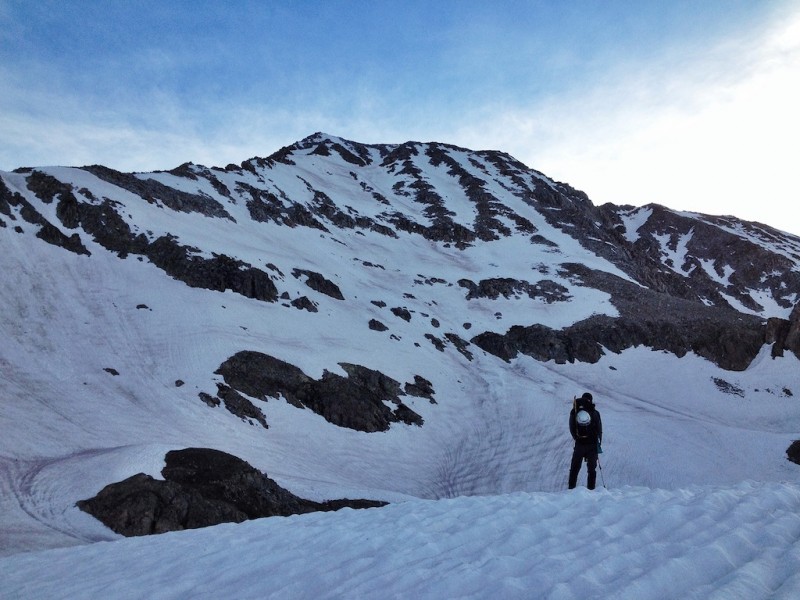
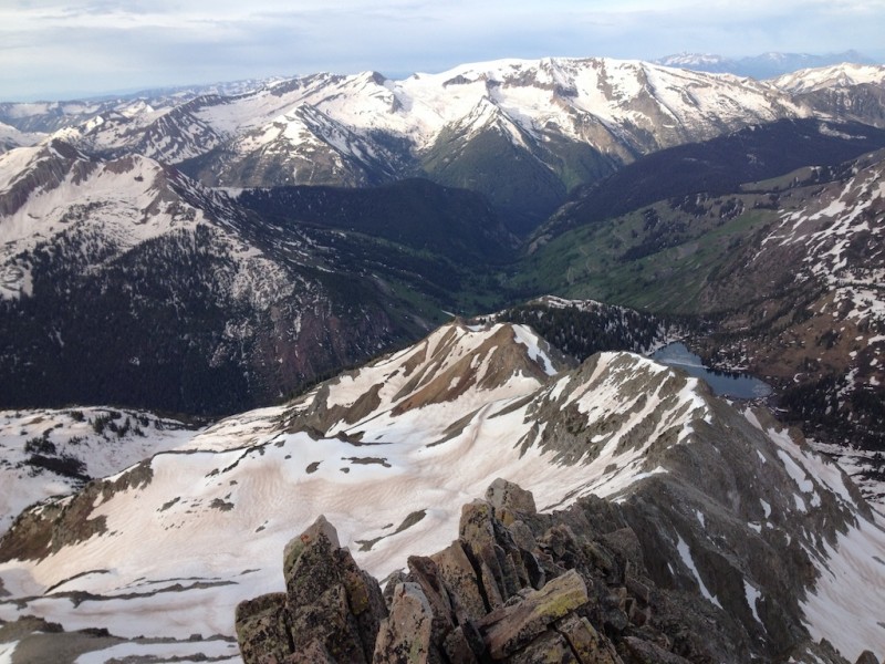
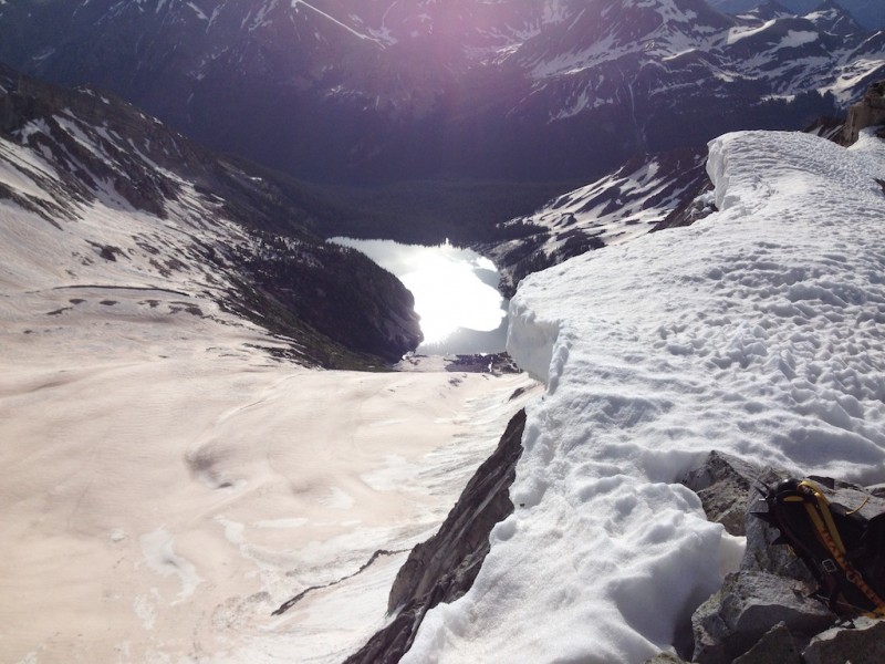
Snowmass and Hagerman from Geneva Lake.
Over the past years, June has proven a sweet spot for summit visits to distant ranges for ngoodnight and me. Sure, it presents logistical challenges (travel, access, sparse intel), especially in high snow years, but it also provides significant advantages (stable weather, low crowds, extended daylight). This June was no different, and it additionally offered an outstanding clinic in snow travel.
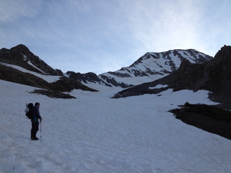
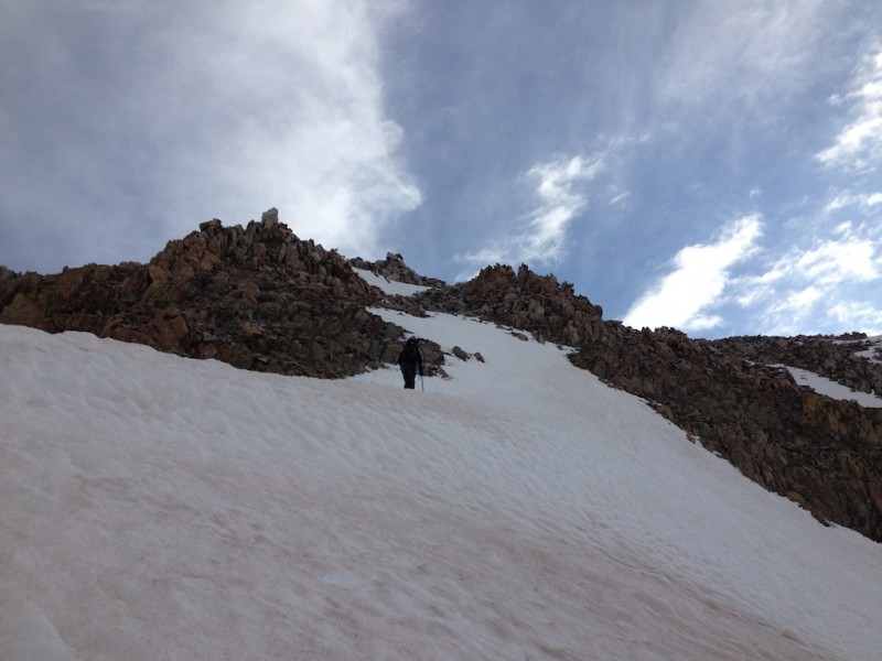
Approaching Hagerman. Firm snow made for easy travel.
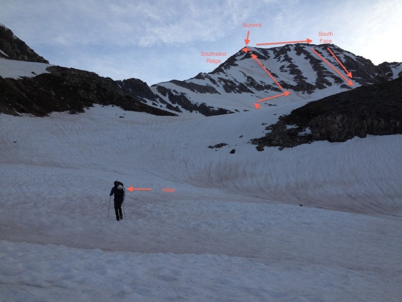
The Intended Route.
Example: Hagerman. The few trip reports out there all suggested either a time-consuming scramble up the southwest ridge, which, don't get me wrong, looked pretty fun, but was, well, time-consuming. And sadly we had a forecast that was not particularly favorable. The Snowmass-Hagerman traverse was right out based on that alone, too. Another option was the tippy-rock ascent up the south face on a route analogous to Snowmass's uncertain west face, should we wait for late summer. Yay, sign me up! Or ... we could gamble that snow on the approach would be minimal and snow on the south slopes would be shutdown solid. Bingo. And that's why I'm writing this report: the snow option. While I have no doubt that many people have climbed Hagerman with snow, I wanted to document a set of logistics for future parties.
Boring Preamble.
As an ill-conceived travel itinerary took us from the San Juans back to the southern Sangres then all the way back up and over the Sawatch to the Elks at Marble, we knew our car would not take us far towards Lead King Basin. (Full disclosure: we understood very early on the car wasn't going anywhere near Crystal or Lead King Basin, but we were too lazy to figure out a workaround until last minute.) Solution? Hire an ATV to drive us in. Added bonus was the encyclopedia of information about the area our driver shared.
Requisite pic of the Crystal Mill. Est. 1893. Discontinued 1917.
Background Info.
Hagerman Peak (13,841') is the tenth-highest peak in the Elks range, the third-highest 13er there, and the 88th-highest peak in Colorado. The Elks range, as most of you know, is renowned for its loose, tippy, crumbly rock. But having discovered first-hand the previous week that the Elks held snow starting at around 11,800', we knew Hagerman and the basin below its slopes would be dealing. After collecting whatever information we could (and many thanks to those who provided info), we figured Hagerman was open for business. So long as business opened well before sun-up, given that the forecast called for a low pressure system to hang over the state and bring storms starting around 10 a.m.
Our general route up, and our general route down.
The Excursion.
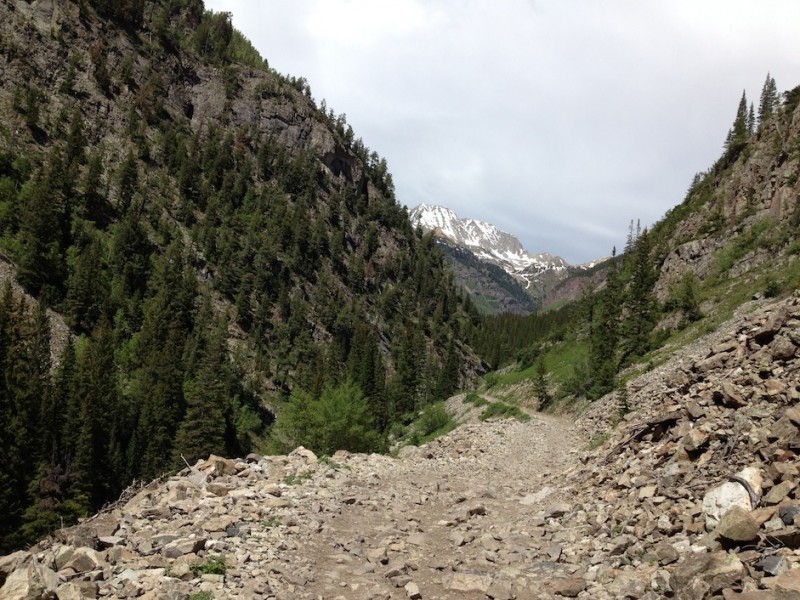
The approach to Hagerman's south slopes takes you up to Lead King Basin and generally follows the standard approach to Snowmass's west slopes and S-ridge"i.e., to scenic Geneva Lake. But there are three options to get to Hagerman from Lead King Basin. (1) You can take the North Fork of the Crystal River approach and follow the well-established trail to Fravert Basin and ultimately backtrack to the basin below Hagerman's south face. Simple and straightforward. The trail split for this option occurs shortly after starting from the Lead King Basin TH (it's obvious and signed), and we explored it first. However, the river was raging there, the crossings were nil, and the consequence for a near-certain slip was immense (think: tumbling down cascading rock). Pass.
The next option, (2) took us up the standard Geneva Lake approach. Here, again, there are two options. You can either cross Geneva Creek below Geneva Lake or above it. We investigated the "below" option, but found the water too wide and deep. Strike two.
So our ascent hinged on (3) fording the river above Geneva Lake. We found a narrow spot that was mercifully not deep, and we made our move. The swift, snowmelt-swollen waters woke us faster than a cup of coffee, but our boots and gaiters held (mostly) and the crossing was quick. This vagary had been my big concern for the day, and it was behind us.
Approaching the river crossing, but on the way out (and oriented accordingly; Hagerman is out of frame far to the right).
At least, the crossing would have been my big concern for the day, had the forecast not called for those storms. We countered with a brisk 2 a.m. alarm, which for a time still threatened to be too late. I won't drag out the suspense. We were down well before the storm hit, although seeing snow squalls on Snowmass in June had its own allure.
After crossing the river, we immediately hit snow and were essentially on snow until we met up with the southwest ridge just below the summit.
Snow in the trees past the river crossing. Taken on the way out and, again, oriented to the descent.
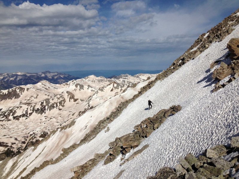
Okay, I know I'm dangerously close to losing some of you with too much text, so I'll just say this before I pipe down and let you veg out with pictures and captions: the south face route follows the right-most gully and rock rib. We whiffed this approach. Instead of taking the path through the cliff bands on the right, we followed an appealing snow gully to the left directly towards the southwest ridge. Indeed, this is the likely approach to the southwest ridge. After ascending even with the cliff bands, we easily concurred that we could traverse the high snow above and around the cliff bands before heading straight up the left-most gully. This saved us around 45+ minutes, which, again with a storm coming, was key. So instead of ascending the south face proper, we picked a slightly different line on the left-most gully, which ultimately met up with the southwest ridge about 150' below the summit. The line was not wildly steep, but the south face (which we descended) was more mellow. I don't have a lot of pics of the ascent (bad pre-dawn light, blocked by the summit ridge), but the ones below are representative enough. Sadly, I also do not have pics of the mountain lion tracks we saw around 12,500'. Rest assured, they were impressive.
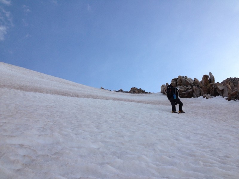
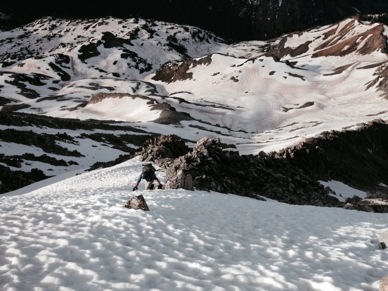
ngoodnight making his way up.
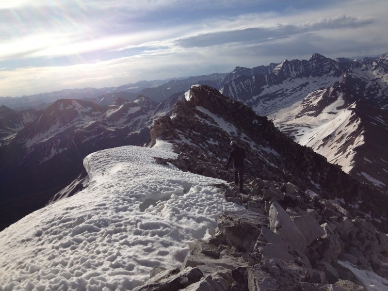
Looking down the southwest ridge. Geneva Lake beyond.
ngoodnight on the summit push. The southwest ridge is on his left.
Me approaching the summit. The southwest ridge is immediately below me. (Photo credit: ngoodnight.)
Our approximate route up and part of the way down.
Summit.
We hit the summit around 7:45 a.m., sent out the requisite messages, took in some magnificent views, and made our way down. The summit views, I shall say, are extraordinary. With the possible exception of Pyramid, I don't think there's a better vista in the Elks. As proof:
I wonder why they call it Snowmass?
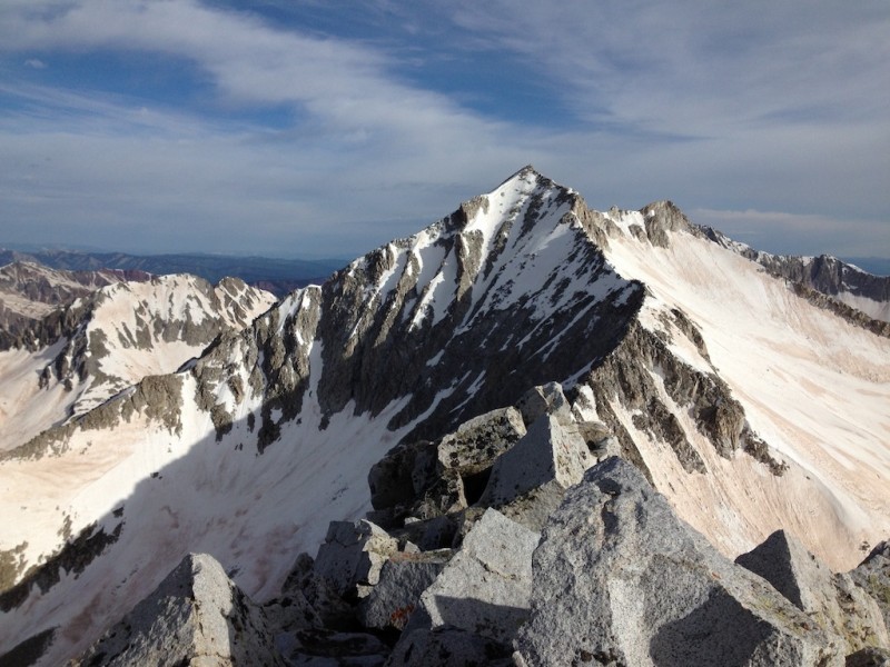
Hagerman's summit ridge, Pyramid, and the Bells.
Hagerman cornice, Snowmass Lake.
On the summit. (Photo credit: ngoodnight.)
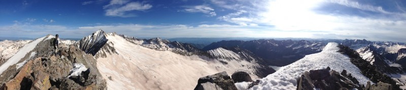
Summit pano. (Photo credit: ngoodnight.)
Time to go. There's a storm coming, after all.
On the way down, we picked our own lines. I opted for the rocks"which were mostly solid and firmly in place"because I wanted to test the "standard" south face route, while ngoodnight opted for the snow ("I came to climb snow, and I'm going to stay on snow!").
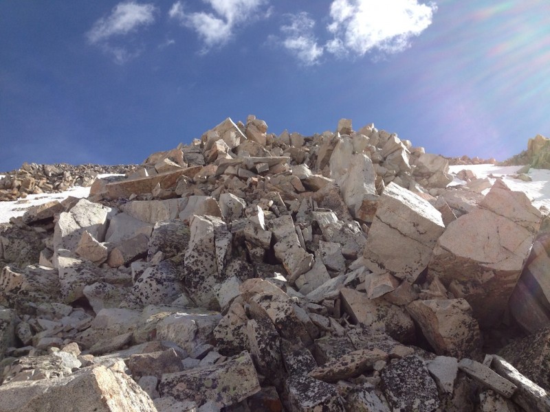
South face rocks. Looks worse than it is.
Ngoodnight enjoying his snow.
Descending the south face rock. Solid! (Photo credit: ngoodnight.)
We both made short work of our descent routes, although ngoodnight obviously cruised down faster.
Cruising down.
On our way out, we followed the standard ascent/descent line to the south face as described by Mr. and Mrs. Roach, which involved snow travel on increasingly less supportive snow, sometimes atop buried streams.
Our approximate route out.
Soon enough we were in the trees, out of the storm's way, and looking forward to re-fording the river.
Walking out. Snow still supportive. Mostly.
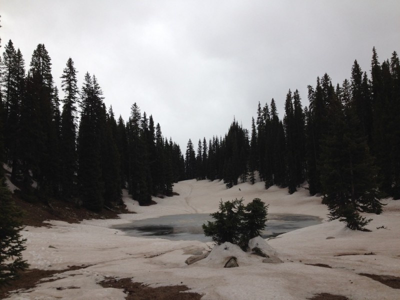
Neat little gem of a partially frozen lake. Tracks indicated people had walked across this a few days earlier. We deemed th
Right about that time, the weather hit Snowmass and Hagerman, and we were quite glad to be lower down.
Snow squall on Snowmass! And that other 13er to the south.
We arrived back at camp with minimal difficulty and well before our scheduled pick up. This gave us ample time to pack our gear, get rained on, and collect a nap.
You'd never know there was snow just above this.
Waiting patiently for collection.
And thoroughly enjoyed the ride out.
As always, I hope this TR has conveyed a modicum of useful info or at least entertainment. There is so much good intel out there that I've been able to use, it is good to give back what I can.
Bye, Hagerman! (Photo credit: ngoodnight.)
Thanks for reading!
The End.
Thumbnails for uploaded photos (click to open slideshow):
Great TR and pics - useful future info, for sure.
Crystal is very full and roaring. That had to be the crux of the climb. :shock:
Strong day for you guys - you found several work arounds as conditions presented themselves. Well done!! Congrats! My personal favorite is the ATV!
Nolan, did you get enough snow?
P.S. I made it through the BORING PREAMBLE. :wink: :D
I've been debriefed. :lol:
Great report and pics, thanks for posting!
I may have missed it, but did you have crampons and/or microspikes to navigate through the snow? just curious to know if one or another are recommended for this type of conditions.
The stream you crossed above Geneva Lake was actually Geneva Creek. The Crystal forks at Crystal: North fork comes down from Lead King Basin, South fork from Schofield Pass. The North Fork of the Crystal is what you follow to Fravert Basin.
Brad, Nancy, Brian -- Thanks for your positive comments. It was quite a fun day!
Kitten -- Axe and crampons required. Spikes would not have been advisable or really sufficient for mere mortals like me.
Raj -- Yes, the snow and rock really worked out in our favor on this one. Congrats on your Lackawanna day, too!
CORed -- Nitpicky, you're right. But better to be accurate. I was thinking of our failed first crossing attempt over the North Crystal on the trail to Fravert Basin, from which we backtracked, and then continued calling it the same. Edited accordingly. Thanks.
Natalie - Thanks! Hagerman would be an excellent peak to ski, which was one of the reasons I posted this TR.
FYI: there is an ATV/Jeep tour service in Marble that will ferry you into and out of Lead King Basin for a modest fee. They either ferry you in individually or you can join a tour and be dropped off. The latter is cheaper, but you have to ensure you are ready to go on the tour's schedule. Added bonus: they give great historical info on the area.
Having done the peak in dry conditions, this report makes me want to go back and ski it! SW ridge is fun, but the snow lines on South face just look sublime. Well, at least now I can patiently wait for it to be in the right condition. :) ATV seems to be a must.
I was looking into ”rent a jeep” scenario, but it looked pricey. So great to know there are options and the pick up/drop off rates are not that bad! Thanks so much for the info - I'd love to do this peak with good snow conditions.
Caution: The information contained in this report may not be accurate and should not be the only resource used in preparation for your climb. Failure to have the necessary experience, physical conditioning, supplies or equipment can result in injury or death. 14ers.com and the author(s) of this report provide no warranties, either express or implied, that the information provided is accurate or reliable. By using the information provided, you agree to indemnify and hold harmless 14ers.com and the report author(s) with respect to any claims and demands against them, including any attorney fees and expenses. Please read the 14ers.com Safety and Disclaimer pages for more information.
Please respect private property: 14ers.com supports the rights of private landowners to determine how and by whom their land will be used. In Colorado, it is your responsibility to determine if land is private and to obtain the appropriate permission before entering the property.


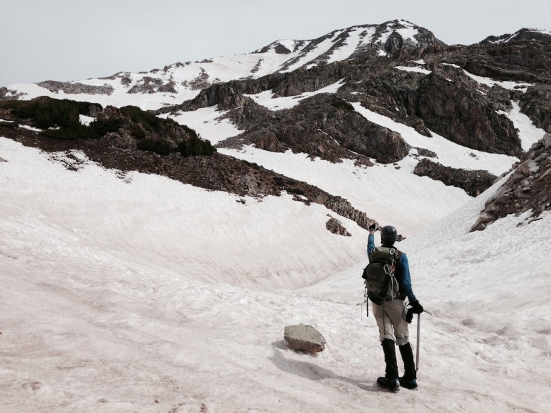
 Contemplating Hagerman.")
 Snowmass and Hagerman from Geneva Lake.")
 Approaching Hagerman. Firm snow made for easy travel.")
 Requisite pic of the Crystal Mill. Est. 1893. Discontinued 1917.")
 Our general route up, and our general route down.")
 Snow in the trees past the river crossing. Taken on the way out and, again, oriented to the descent.")
 Approaching the river crossing, but on the way out (and oriented accordingly; Hagerman is out of frame far to the right).")
 ngoodnight making his way up.")
 Looking down the southwest ridge. Geneva Lake beyond.")
 ngoodnight on the summit push. The southwest ridge is on his left.")
 Me approaching the summit. The southwest ridge is immediately below me. (Photo credit: ngoodnight.)")
 I wonder why they call it Snowmass?")
 Hagerman's summit ridge, Pyramid, and the Bells.")
 Hagerman cornice, Snowmass Lake.")
 On the summit. (Photo credit: ngoodnight.)")
 Summit pano. (Photo credit: ngoodnight.)")
 Time to go. There's a storm coming, after all.")
 South face rocks. Looks worse than it is.")
 Ngoodnight enjoying his snow.")
 Descending the south face rock. Solid! (Photo credit: ngoodnight.)")
 Cruising down.")
 Walking out. Snow still supportive. Mostly.")
 Neat little gem of a partially frozen lake. Tracks indicated people had walked across this a few days earlier. We deemed th")
 Snow squall on Snowmass! And that other 13er to the south.")
 Waiting patiently for collection.")
 And thoroughly enjoyed the ride out.")
 You'd never know there was snow just above this.")
 Bye, Hagerman! (Photo credit: ngoodnight.)")
 Our approximate route out.")
 Our approximate route up and part of the way down.")