Download Agreement, Release, and Acknowledgement of Risk:
You (the person requesting this file download) fully understand mountain climbing ("Activity") involves risks and dangers of serious bodily injury, including permanent disability, paralysis, and death ("Risks") and you fully accept and assume all such risks and all responsibility for losses, costs, and damages you incur as a result of your participation in this Activity.
You acknowledge that information in the file you have chosen to download may not be accurate and may contain errors. You agree to assume all risks when using this information and agree to release and discharge 14ers.com, 14ers Inc. and the author(s) of such information (collectively, the "Released Parties").
You hereby discharge the Released Parties from all damages, actions, claims and liabilities of any nature, specifically including, but not limited to, damages, actions, claims and liabilities arising from or related to the negligence of the Released Parties. You further agree to indemnify, hold harmless and defend 14ers.com, 14ers Inc. and each of the other Released Parties from and against any loss, damage, liability and expense, including costs and attorney fees, incurred by 14ers.com, 14ers Inc. or any of the other Released Parties as a result of you using information provided on the 14ers.com or 14ers Inc. websites.
You have read this agreement, fully understand its terms and intend it to be a complete and unconditional release of all liability to the greatest extent allowed by law and agree that if any portion of this agreement is held to be invalid the balance, notwithstanding, shall continue in full force and effect.
By clicking "OK" you agree to these terms. If you DO NOT agree, click "Cancel"...
The most exciting trip report ever written on Rosalie Peak, EVER!
Gotcha! But it will be kind of exciting.
Strava gave me:
12.2 miles
4,578 feet of gain
4.5 hours with breaks
Since Mount Audubon I have climbed other non-14 thousand foot peaks namely Apache Peak, Navajo Peak, and Niwot Ridge in its entirety. That was a far more exciting day (first time in crampons) but I have also grown lazy so you get a report on Rosalie. As well, Abe and I had another even more epic trip to Utah for memorial day weekend and I ran some mountains no one cares about. One day I will probably climb a 14er again but since last summer my drive has changed. I want to run up everything. Really digging the new method I have employed. Open up a map, pick peak(s), go for it. I only care about the vert. I have become a vert monster.
I opened up my Idaho Springs, Georgetown, Loveland pass map on Sunday evening and started poking around. Down in the bottom right hand corner of the east side I noticed Deer Creek TH and followed Tanglewood Trail north and spotted Rosalie. I was sold once I found out the TH was only 50 minutes away from my apartment. Such an easy drive...470 to 285 to 43 (before Bailey). 43 is a paved road and very easy to follow, stay left at the junction with 47. Before 43 hits the Deer Creek campsite it turns to a dirt road. I did not know what to expect beyond this point (about 0.8 miles to actual TH) but being the devilish risk taker I am I forged on and my tiny two door honda civic made it no problem.
I started at 8 a.m. me, myself, and I. I wore minimalist trail runners and a nathans hydration pack with small snacks and a rain coat stuffed inside.
Things were going well for the first mile and a half or so. It was chilly but I was running and making good time. I came to the junction with Rosalie Trail but continued on Tanglewood towards the saddle of Rosalie and Pegmatite. Deer Creek was raging and the sound of water followed me the entire time. It was glorious. The trail was in ruff shape and gradually became impossible to run. Deer creek was creeking all over the place and the "trail" became a stream of slippery roots, wet loose rock, and mud...oh the mud. Being the lover of nature I am I refused to side skirt this hot mess so I ended up with VERY wet/dirty feet.
The creek from hell.
Shockingly enough the trail really went up, for like a really really long time. My thought process went something like this: "Oh this is so beautiful, majestical glorious nature, oh how I love you. Listen to those birds chirping, Oh there's some squirrels fighting, how cute." "Hmmmm....that root was slippery, that was fun how that mud just took my shoe off...I'm running through a creek, awesome." "Oh my god another creek crossing." "Holy crap this is really steep, wait where is the trail? this all looks the same.. Oh cairn...phew." "Now I am slipping all over the place and being assaulted by every biting bug that ever existed. Man I am so hungry but can't stop." "tree line, WHERE THE HELL IS TREE LINE?!?!!?"
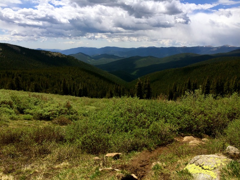
Tree line came and was absolutely stunning. This area is soooooooo nice. I was pleasantly surprised. Creek trail did not let up until I made it to the saddle (around 12,000 feet) and I had to cross one small snow field.
Tree Line
Saddle
I knew from the saddle I would climb Rosalie's east side and I knew that this would entail 1,600 feet of gain in about a mile. Yum. Here I go. I started off in a light jog. This lasted about 10 minutes before altitude punched me in the quads and said, "you're power-hiking." So power-hike I did. The power hiking lasted until about 700 feet from the summit where altitude punched me in the lungs and said, "you're walking." So walk I did. This lasted until I was about 300 feet from the summit when altitude punched me in the head and said, "you're not going to make it." Um, yes I am. I started counting off paces, 200, 10 second rest, 200, 10 second rest, and eventually I was standing on top of the cairn at the summit in the freezing cold wind. I enjoyed the views for about 50 seconds before my face, hands, ears, and teeth went numb. Jogged back to the saddle while eating probar chews.
Summit Rosalie
I had big plans to continue on to Epaulet but the clouds were swirling and darkening and.......no, I can't lie, Rosalie kicked my ass and the thought of another 1,600 feet of gain was absolutely terrifying even for the vert monster. I had a contingency plan, Pegmatite Points.
The wind was furious and unrelenting but the points offered some little scrambles and I was having type two fun. There is fun that comes in the form of suffering (type one) (attempting to run up Rosalie) and fun that comes in the form of having my hand on some rock (type two). A combo of type one and two is ideal. I enjoyed the playground over to the high point of 12,227.
Heading towards the Points.
I call this look the mountain mullet. Really hip stylist, the wind.
I once again returned to the saddle, reconnected with the trail, and ran/jog/slid/fell back to my car.
Runnable sections of trail.
On the way out I was able to catch a large heard of these majestical creatures of the mountain grazing.
Mountain dualicorns
What a lovely area.
The End.
Thumbnails for uploaded photos (click to open slideshow):
That WAS the most exciting tr of Rosalie I've 6/24/2014 3:34pm
read. It's also the only one, but exciting none the less. The vert monster sounds scary!
I love image 5. Thank God those flowers were there, the mountain is otherwise really colorless.
"All in all the clock is slow. Six color pictures all in a row, of a marigold." I don't suppose those flowers are marigolds? I was just listening to that song.
Mike, that mountain has a few snowfields, it cannot be THAT ugly. :? Maybe you can do laps?
Kay - nice report. Next time, save some energy and go check out the Epaulets - the view of Bierstadt from there will restore your faith in that mountain. Once you catch the trail in the basin below it goes pretty quick back to the TH.
I am afraid the most exciting report on Rosalie is this one. Not sure if ”exciting” is the right word though.
Really enjoyed your TR. It makes me want to do this one even more now. I would like to do the Epaulets too, but it sounds like Rosalie is bit of a beast. Really enjoyed your "most exciting report" though. Great pics.
Really enjoyed your TR. It makes me want to do this one even more now. I would like to do the Epaulets too, but it sounds like Rosalie is bit of a beast. Really enjoyed your "most exciting report" though. Great pics. Pegmatite Points look like a nice little side trip, too! Thanks for the tip!
Caution: The information contained in this report may not be accurate and should not be the only resource used in preparation for your climb. Failure to have the necessary experience, physical conditioning, supplies or equipment can result in injury or death. 14ers.com and the author(s) of this report provide no warranties, either express or implied, that the information provided is accurate or reliable. By using the information provided, you agree to indemnify and hold harmless 14ers.com and the report author(s) with respect to any claims and demands against them, including any attorney fees and expenses. Please read the 14ers.com Safety and Disclaimer pages for more information.
Please respect private property: 14ers.com supports the rights of private landowners to determine how and by whom their land will be used. In Colorado, it is your responsibility to determine if land is private and to obtain the appropriate permission before entering the property.


 The creek from hell.")
 Tree Line")
")
")
")
")
 Saddle")
")
 Summit Rosalie")
")
 Heading towards the Points.")
")
")
 I call this look the mountain mullet. Really hip stylist, the wind.")
 Runnable sections of trail.")
")
 Mountain dualicorns")
 The End.")