| Report Type | Full |
| Peak(s) |
Pikes Peak - 14,109 feet |
| Date Posted | 06/09/2014 |
| Date Climbed | 06/08/2014 |
| Author | njlinderer |
| Additional Members | Theodore |
| Y-Couloir |
|---|
Ted (Theodore) and I drove out for our second attempt at the Y-Couloir on Pike's Peak on Friday. It was a snap decision based on late subtle improvement in the sketchy weekend forecast. The hell with it, we figured. We can only know if we show up. We drove through a heck of a storm near Colby, Kansas- one that picked up a load of red dirt and looked like something fierce from the 1930's racing across the plains. It's literally impossible for me to drive from Kansas City to the Front Range without getting into something.  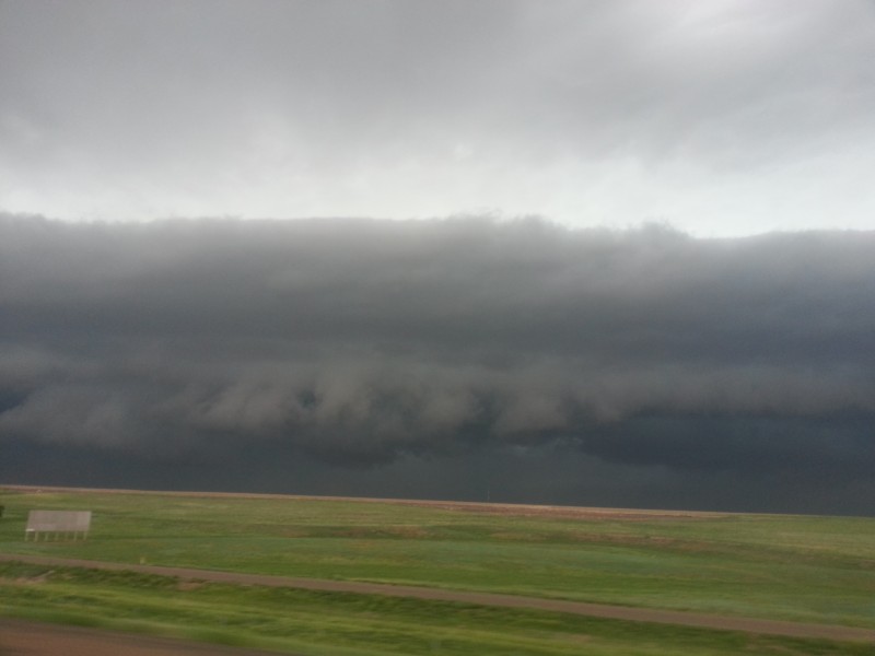 Anyway, we made it to our seedy motel without incident and boarded the COG RAILWAY Saturday afternoon. Cool! Full disclaimer- in an attempt to maximize the chances of us getting this route and the mountaineering experience provided by it, we took advantage of the mechanical advantage available to us while still easily gaining 3K+ under our own power. We ditched out at "Mountain View" and hiked through Barr Camp into the Bottomless Pit for our planned bivy. Barr camp was pretty neat. Neither of us had been there yet and the caretaker, Anthony, was a super nice guy with a really great beard. Oh, and also a shout out to Phil at Mountain Chalet for busting out the photocopier for our maps. Easy hike toward the cirque and we found a decent place to pitch our small camp a bit below the Pit proper. By this time the sun was out and beginning to poke holes in the forecast, and it seemed like maybe the mountain would let us get a little closer this time.  We witnessed a pretty sunset and then got some kind of Stephen King updraft as a thick, gray fog swept up the mountain into the prevailing westerlies, consuming us. Eerie. Awesome. Dynamic weather systems. Colorado. Little did we know you guys would get a tornado out of it. Now you know how we feel. 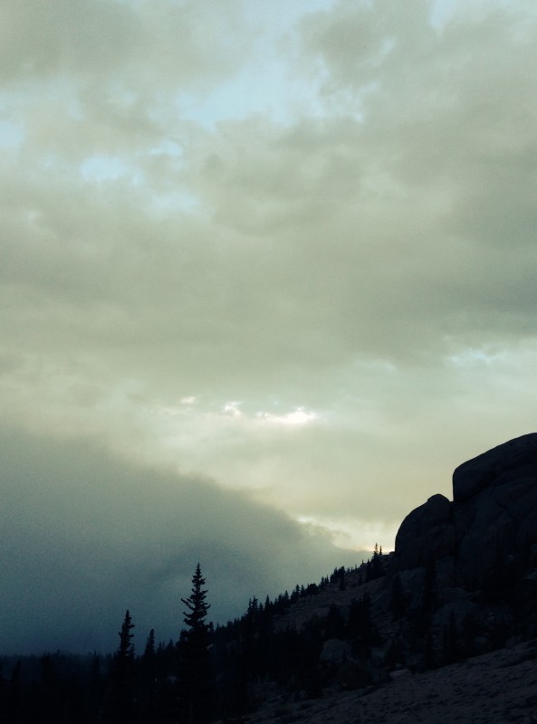   After the sleepless night we were greeted by a Cascadesque sunrise with ribbons and blankets of clouds stretching out over the plains in a frothy, pink and orange sea. Above us? Clear skies and bright stars. Time to go.    Now for the beta: We broke camp about 5 am and had a bit of difficulty keeping the "route" to the base of the couloir. We ended up descending a bit and picked up some small cairns and a boot pack well below the cliffs to the left (east). There were some scattered snowdrifts still there, which post-holed us, but for the most part they can be avoided. The objective became obvious when we got around the system of ledges and cliffs that obscured the couloirs from our camp, so not having a definitive trail wasn't a huge deal in this place. We noticed immediately that the Railroad Couloir was almost entirely melted out- it's done for the year. The old car wreckage was probably a few hundred feet lower than the first continuous snow we got into.    Past the small boulderfield that we wished was a snowbowl, we geared up for climbing at about 12,500 and found great snow conditions there. Made good time up firm snow through the large gap between the two cliffs that guard the bifurcation of the Y. This should be called the Gateway to Fun even though it looks more like Atreyu's Northern Oracle...     We chose the left branch and because there was a thin ribbon of snow splitting the rock band that looked easier to contend with. It will be melted out and more difficult soon. The right branch would have been trickier to access as it's opening was in direct sunlight, which was quickly softening anything it touched.   There is a lot of melting going on up there right now. Even so, starting as early as we did there was very little rock fall. Obviously this route is going to be out SOON, so get after it now! There was a stout boot pack in the upper portions of the left branch, which allowed us to absolutely smoke it time wise. The finish was pretty spectacular as the couloir narrowed and steepened and we even got a small section of ice right below the summit that was easily climbable due to solid adjacent rock holds. Looking down the upper portions of the route it is apparent that most all of the Y is a no fall zone and I think we had to have exceeded 50 degrees on a few portions of the upper mountain. We topped out about 9 am to wonderful, breezy weather...and a tour bus with dozens of bicycles strapped the roof.    It was strange seeing people and a building there, but you just have to take it for what it's worth and enjoy the hot coffee. Pike's is an amazing mountain because of its sheer size, accessibility, and the mountaineering playground on the underappreciated north face. The cirque below the face is an awesome place with its steep cliffs and green moss. We enjoyed it immensely and found the route close to what we expected and well within our comfort level. I think we are both ready to take the next step into mixed climbing and we look forward to the slow evolution of our skills and the curse that can only be called The Kansas Mountaineering Problem.  Thumbnails for uploaded photos (click to open slideshow):  The drive.")
 Big storm.")
 The trail.")
 The Fog.")
 Fog rolling up toward us.")
 Dawn.")
 Sea of clouds.")
")
 The cirque. Pretty thin up there.")
 Starting up the boulder bowl.")
 Happy.")
 Base of the couloir, you can see how gone the Railroad is.")
 Lower Y.")
 Ted climbing.")
")
 Ted nearing the split. You can see a small passage of snow in the rock band near the left.")
 About 45 degree slopes we think, fun climbing.")
 Upper Y, angle steepening.")
 Final move below the summit. There is ice here.")
 Me on the crux right before topping out.")
 Great friends, great route, great summit.")
 Just over half a moon.")
|
| Comments or Questions | |||
|---|---|---|---|
|
Caution: The information contained in this report may not be accurate and should not be the only resource used in preparation for your climb. Failure to have the necessary experience, physical conditioning, supplies or equipment can result in injury or death. 14ers.com and the author(s) of this report provide no warranties, either express or implied, that the information provided is accurate or reliable. By using the information provided, you agree to indemnify and hold harmless 14ers.com and the report author(s) with respect to any claims and demands against them, including any attorney fees and expenses. Please read the 14ers.com Safety and Disclaimer pages for more information.
Please respect private property: 14ers.com supports the rights of private landowners to determine how and by whom their land will be used. In Colorado, it is your responsibility to determine if land is private and to obtain the appropriate permission before entering the property.


