Download Agreement, Release, and Acknowledgement of Risk:
You (the person requesting this file download) fully understand mountain climbing ("Activity") involves risks and dangers of serious bodily injury, including permanent disability, paralysis, and death ("Risks") and you fully accept and assume all such risks and all responsibility for losses, costs, and damages you incur as a result of your participation in this Activity.
You acknowledge that information in the file you have chosen to download may not be accurate and may contain errors. You agree to assume all risks when using this information and agree to release and discharge 14ers.com, 14ers Inc. and the author(s) of such information (collectively, the "Released Parties").
You hereby discharge the Released Parties from all damages, actions, claims and liabilities of any nature, specifically including, but not limited to, damages, actions, claims and liabilities arising from or related to the negligence of the Released Parties. You further agree to indemnify, hold harmless and defend 14ers.com, 14ers Inc. and each of the other Released Parties from and against any loss, damage, liability and expense, including costs and attorney fees, incurred by 14ers.com, 14ers Inc. or any of the other Released Parties as a result of you using information provided on the 14ers.com or 14ers Inc. websites.
You have read this agreement, fully understand its terms and intend it to be a complete and unconditional release of all liability to the greatest extent allowed by law and agree that if any portion of this agreement is held to be invalid the balance, notwithstanding, shall continue in full force and effect.
By clicking "OK" you agree to these terms. If you DO NOT agree, click "Cancel"...
Electric Peak and Lakes Peak
16.4 miles RT, 6500' gain, 8 hours
From Major Creek TH (8,620 ft)
Partner: Brian Kalet
I left my house at 4am and picked up Brian at 6 in Johnson Village, he was staying in the area. From the 285/17 junction, county roads GG and 65 are well graded all the way to the Major Creek trailhead, I drove my 2wd car which was fine. We hit the trail about 7:30 am.
The trail heads south for almost a mile and descends to Major creek, then heads east. The creek was not flowing very high and was easily crossed when the trail crossed it. There was only one location with evidence of recent beaver activity, a few aspens cut and laying across the trail. The re-routing of the trail north and high above the beaver ponds made for easy travelling.
The excellent trail continues all the way to the 12,500 ft Electric/Lakes saddle and we made great time. There was very little snow left, just a few patches in the trees above 10.5k. Good decision to leave axe, gaiters, and spikes behind.
Pt 13220 with Electric peak just beyond: Pt 13220 with Electric Peak beyond
From the saddle we decided to do Electric first, since it was higher and furthest away. The 60% chance of storms was concerning and clouds were already building. It's an easy hike staying close to the ridge crest, mostly grass mixed with some talus. There's a small drop on the south side of Pt 13,220, then a quick and final 500' of gain to Electric's summit at about 11:30am. No register, but great views south into the heart of the Sangres.
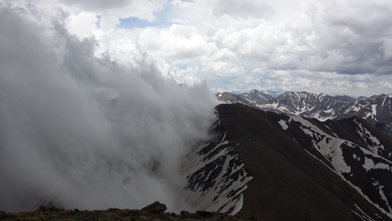
Clouds on the Sangre crest: Clouds on the Crest
Lakes Peak with Cottonwood rearing up behind it: Lakes Peak. Cottonwood rising up beyond
The weather was looking rough so we hustled back down the saddle and up to Lakes peak as fast as we could go, arriving about 12:45pm. This one had a register, and nice views north to the Cottonwood group which we'll be hiking soon. The clouds were forming at the crest and building east, with a couple lightning strikes perhaps ten miles NE. As we descended Lakes the weather actually improved so we took a lengthy break at the saddle. The hike out was long but went well, we were back at the car by 4pm. On the drive out we checked out Valley View Hot Springs, but they had reached their quota of guests for the day and weren't letting anyone else in. The $15 fee seemed a bit steep so I'm not sure we would have done it anyway.
Awesome early season hike to the top of the Sangres!
My GPS Tracks on Google Maps (made from a .GPX file upload):
Thumbnails for uploaded photos (click to open slideshow):
Comments or Questions
Caution: The information contained in this report may not be accurate and should not be the only resource used in preparation for your climb. Failure to have the necessary experience, physical conditioning, supplies or equipment can result in injury or death. 14ers.com and the author(s) of this report provide no warranties, either express or implied, that the information provided is accurate or reliable. By using the information provided, you agree to indemnify and hold harmless 14ers.com and the report author(s) with respect to any claims and demands against them, including any attorney fees and expenses. Please read the 14ers.com Safety and Disclaimer pages for more information.
Please respect private property: 14ers.com supports the rights of private landowners to determine how and by whom their land will be used. In Colorado, it is your responsibility to determine if land is private and to obtain the appropriate permission before entering the property.
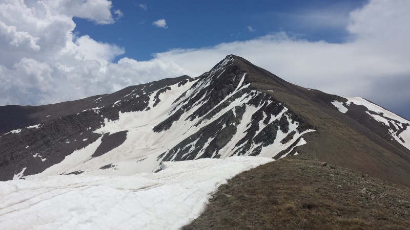

 Pt 13220 with Electric Peak beyond")
 Lakes Peak. Cottonwood rising up beyond")
 Clouds on the Crest")

