
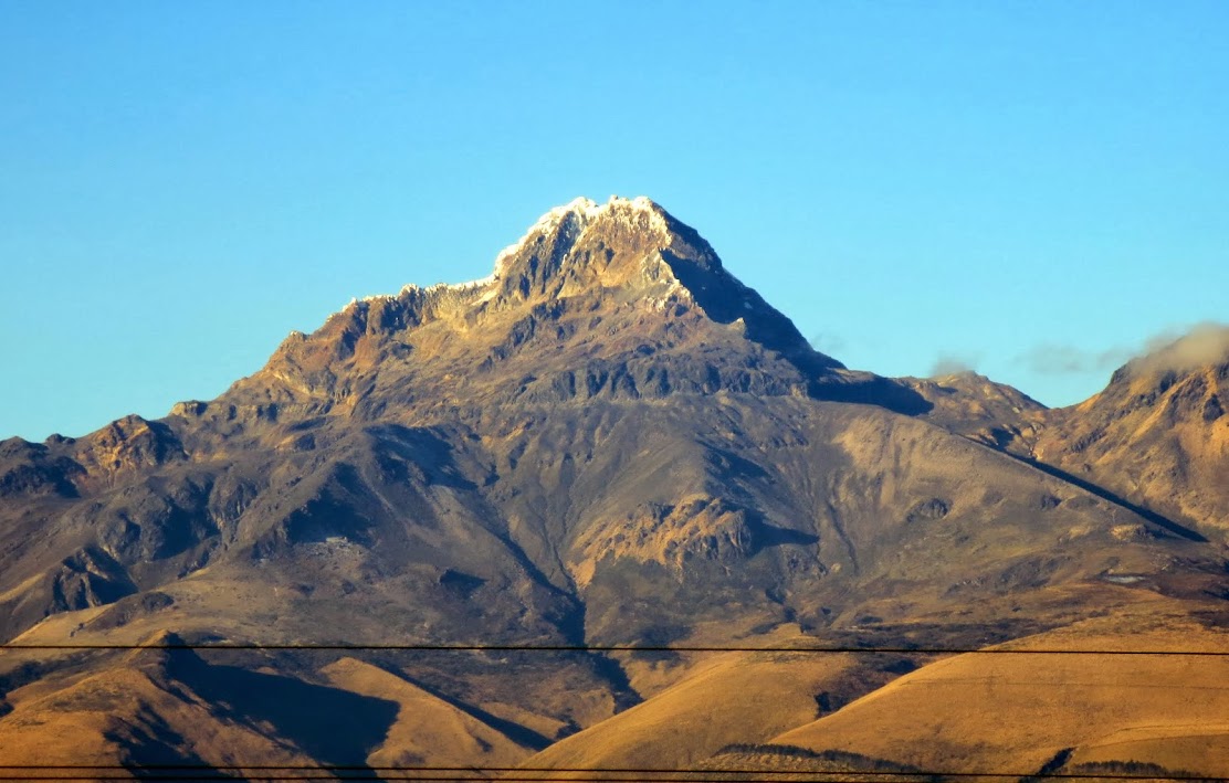
Illiniza Sur, 5263 m / 17,267 ft (AD+)
December 29-30, 2013
Group: Steph, Guide Edgar Vega (edgarguide63 AT gmail.com)
Normal route with left branch option near the summit
~7 mi/4500 ft gain. 2.5 hr approach to Nuevos Horizontales refugio at 15,450 ft, 6.5 hrs RT from refugio, and 1 hr refugio to TH descent.
Ice and glacier travel to 70 deg, 4th class rock. 4 screws, 2 pickets, two ice tools/axes, crampons, and rope used.
Cost: $380 for two.
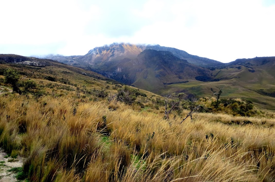
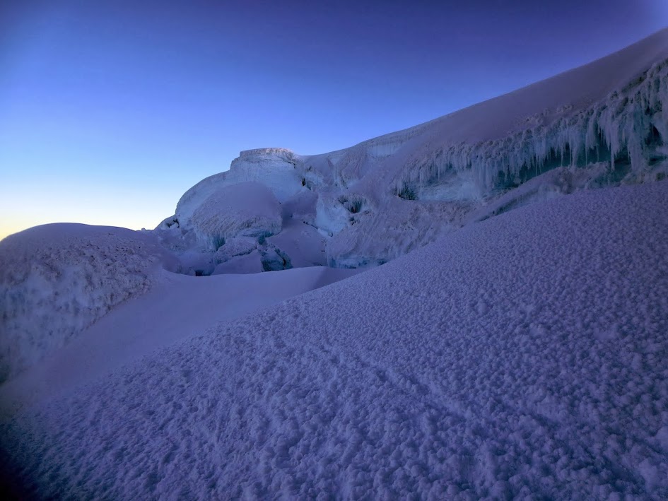
The only time we ever actually saw the peak:

Cayambe, 5790 m / 18,996 ft (PD)
January 2-3, 2014
Group: Guide Juan with Edgartrek (same contact as above). Steph to 16K ft.
Normal route.
~4mi/3500 ft, 8 hrs RT from refugio/TH.
Glacier travel to 35 deg, 2+ class rock. Crampons, ice axe, and rope used.
Cost: $400 for two.

Compromise. That dreaded word! Capable of eliciting a parade of rebellious, independent notions. Notions that, in hindsight, tend to appear rather silly.
(I tried to sneak the word "occasionally" in front of "tend," but Steph made me delete it)
A situation in which many are familiar with: my lady enjoys travel a tad bit more than she enjoys peaks and I enjoy peaks a tad bit more than I enjoy travel. Factor in weather, work, and financial considerations and we're ultimately left deciding between Hawaiian and Ecuadorian volcanoes.
The symbol of Ecuadorian mountaineering

A few friends and acquaintances were planning a trip to Ecuador, tipping the scale. Unfortunately, we aren't able to reconcile ticket prices, airline miles, acclimatization, home closing costs, and other life aspects. I'm sure they'll do their own report as they were able to fit other peaks in.
So our group had been pared down to a lovely lady and her charge. And the guide, transforming the pair into a cumbersome trio.
Still, the guided aspect has its perks, particularly when it comes to planning. Meals, refugios, permits, transportation, route-finding, and the bulk of the group technical gear taken care of at the mere cost of 1.5 Arc'Teryx jackets, the soon-to-be universal unit of mountaineering costs.
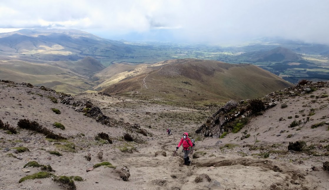
Approaching Nuevos Horizontales

The first day is spent recovering from the usual ails of airline travel in Quito's famed and friendly Mariscal Sucre neighborhood. In the midst of an extended holiday, the shop windows are shuttered, the compound gates locked, and the rollover doors settled firmly into place. Crap. Not all that conducive towards those running pre-climb errands.
The city hustle is quelled and we, the two blindingly pale and marginally queasy gringos freshly unencumbered by luggage, are roaming the bare streets in search of a shop to rent double boots. Expectedly, the tour operator fronts are open and we're able to rent boots at $5/day, buy food and drink, and arrange tours for our days off.
The route follows the red line top left.

On our second day, Edgar picks us up in his vintage Landcruiser and we begin the scenic ride to Los Virgens trailhead with a minor stop for food. The highways of Ecuador are relatively clean, smooth, and dark, having been recently paved and maintained in the name of tourism and progress. Still, a cobble street and bumpy dirt road to just under 13,000 ft contribute to a nauseating refuge approach, which is made easier by the unexpected and welcome use of a pack horse.
The approach, 2.5 hrs at an altitude savvy pace, follows an eroded road alongside yellowed, waving hills and the requisite cow pies prior to ascending a broad, well-trodden gray ridge next to a picturesque basin. It isn't long before Steph breaks her altitude record. Once above the ridge, a quick flat stretch alongside a lateral moraine sees one at the eyesore pink refuge. The refuge sleeps around 30 people in cramped quarters and has a decently sized kitchen, table, and modern toilets.

At the refuge, we're delighted that the other two Americans are familiar faces - Jeff and Mike from Colorado, who were returning from a quick assault (~2hrs RT) on Illiniza Norte and were planning on Cotopaxi after a nights' rest. We spend time catching up, drinking tea, eating tea grains after the bag fails, and gorging on surprisingly delicious meals prepared by combined efforts of the guides. At this point, the whole guiding thing doesn't seem so bad.
An attempt is made to sleep, but we succumb to a restless rustle in which every slight discomfort is the dark-winged harbinger of altitude sickness. We get up at 3AM and eat breakfast, to the annoyance and subsequent arising of the refugio's other occupants. One does not simply sleep in in a refugio.
The route ascends a decent trail up moraine remnants to the saddle between Illiniza Sur and Norte prior to traversing scree and rock under a hazardous area. Pre-glacial melt, this was considered a fast and easy snow traverse. Now, it is tedium defined and one must keep an ear open for widow-makers. Nevertheless, the section is short and is followed by a quick scramble up a chimney and over a rib - two moves of 4th class followed by a few moves of third. The guide belays us from above. Above is a flat section purposely made by the volcano for the sole use of us humans in order to don crampons prior to ascending a glacial ramp.

Our pace? Well, boring. Hypochondriac havoc on the mind. The key to these moderately high peaks is not drinking water, slowly ascending, and all of that hog wash. No, the true secret is menthol cough drops and a good hiking song. Rudolph the Red-nosed Reindeer and Hakuna Matada seem to do the trick. The cough drops keep one's mind busy and are, to be honest, one of my few closet addictions, in addition to wearing women's clothes, if one were to ask Ecuadorian airport security.
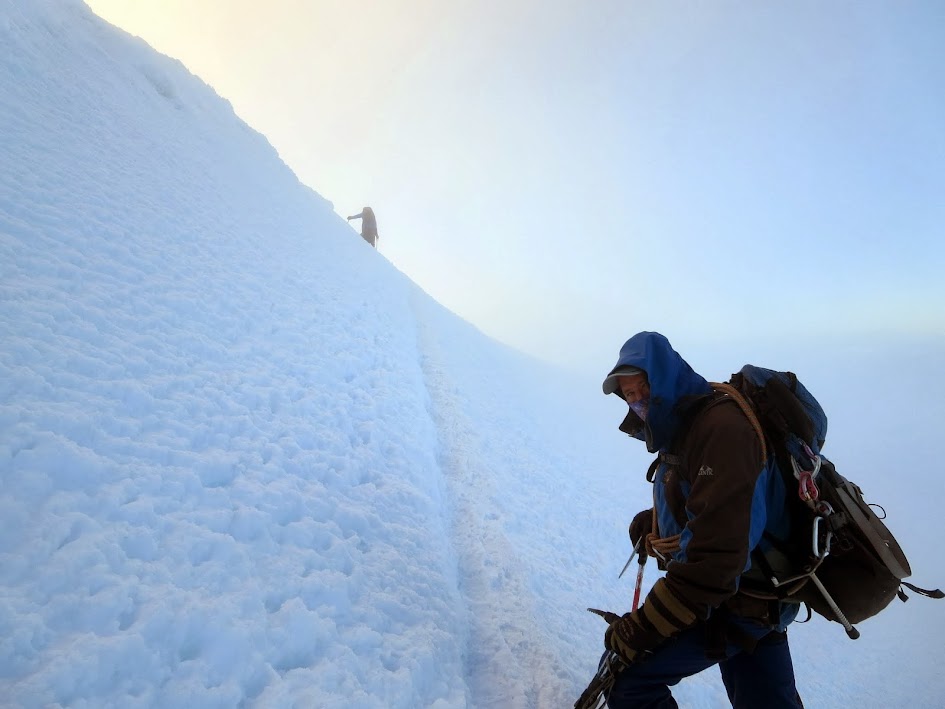
The next section consists of several hundred feet of mixed dirty glacial ice and good crampon snow up and slightly left in a shallow gully threatened by rock buzzers on left and minor seracs on right, the slope gradually increasing from 35 to 70 degrees. Luckily, the clouds prevent us from seeing the rocks and seracs very clearly and we plod on blissfully only slightly aware. An axe in hand clanging uselessly off the surface and a tool producing reassuring THUNKs. Front points in, the guide leads the simul-climb with Steph just behind him and me at the rear. He's happy Steph and I brought a screw each and they were used along with his two.
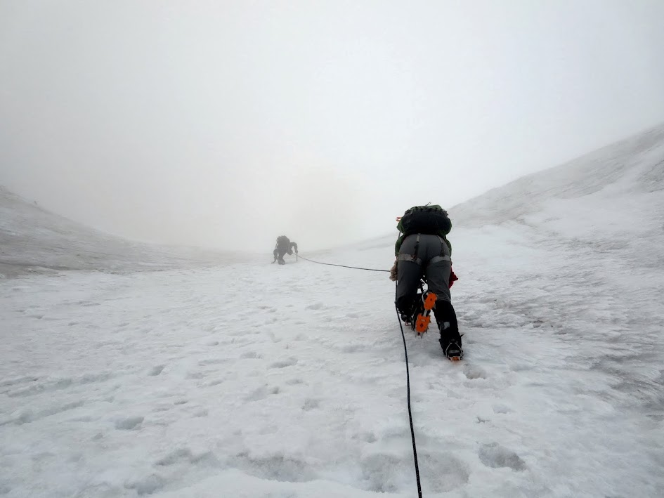
Eventually, he slams a picket in and belays us up to a shelf marking the midway point and start of the more-crevassed terrain. Another party of two is on our heels and passes us during a bathroom break.


A quick break and our guide is antsy to move, eyeing looming seracs and rock debris paces away. We zigzag moderate angle snow slopes and hold our breath crossing the larger crevasses. The bridges are solid and broad enough, though the crevasses are well positioned to catch a poorly arrested fall. Which is exactly what happened here years ago and contributed to the whole mandatory guide debacle in the first place.
With the fringes of mental and physical exhaustion affecting the party, we reach the final ramp, perhaps 40-50 degrees, and slowly climb upwards. It isn't as steep as the first, but it is icier, dirtier, and harder to kick into.

Steph is a bit newer to this game and the prospect of rolling the ankle to engage all points is intimidating on this sort of slope. Perhaps we should've worked on that beforehand. Nevertheless, she claws her way through and a quick snow ramp to the right of an icy cornice leads us to the summit. A clouded one, with snow lancing across the face.

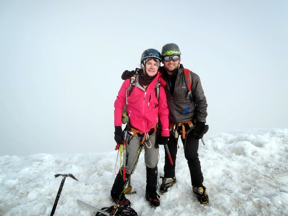
Steph's first high altitude experience and no gimme at that. Her toughest peak to date. I hate to go into feelings since Men are supposed to be Men and whatnot, but I was quite proud.
However, the hard part remains. The guide keeps us on a tight leash as we downclimb, myself at the lead and Steph on a tight rope between. Even worse than climbing up is climbing down and the dicey, balance-y prospect of walking down glacial ice facing outwards as the guide does is intimidating. We take our time descending facing in. We cross the crevasses and simul climb down the first ramp, the guide above feeding rope, Steph in-between acting the rose between two thorns, and myself placing screws as we descend. A few iterations later and we're off the snow, removing crampons and rappelling the rock. The guide has us continue as he coils the rope. We're treated by a brief cloud partition and views of Norte.


Bags packed, we trudge down to the car. Nice, soft scree makes for considerably faster time. A couple hours of driving later, we were relaxing at the hostel and hunting for food.

Taken next day (climb via the opposite side)
The fourth day was spent travelling to Banos with a flexible guided group. Dubbed Ecuador's adventure capital of sorts and nestled in the shadow of Tungurahu, there were plenty of waterfalls to see, weird fruit to try, and guinea pigs to eat (cross between dark turkey and pork, too much effort for the meat).
Our companions for the trip included a Columbian couple (young college student gold-digger, wealthy older businessman vibe), a Mexican pilot, and a grandfather/grandson pair from Israel. Our guide was an eco-friendly, high energy Ecuadorian with good insights, conversation, and kind enough to choose restaurants without a gringo tax and bargain for us at the markets. In return, we were able to explain to him what a Cougar and Cougar-bait were. The Colombian pair started the humor off awkwardly by informing the Israelites that they were actually from Palestine. Not the best joke in the world. Fortunately, by the end of the trip, everybody got along well enough and the conversation was flowing.
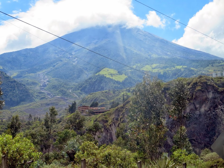
Tungurahu


Geology


If one were to walk the streets of Ecuador New Years' Eve, they might notice a couple things: scantily clad women flaunting wares behind copious roadblocks and demanding money or candy in exchange for passage, and child-sized stuffed human effigies (Ano Viejos) with painted wooden masks burning in the middle of the street. The latter is a manner in which one symbolically rids themselves of the past year's problems or delivers a political statement. The former involves the "widows" of those dolls asking for recompense.
Did I mention the panty-clad, breast-baring women are actually boys and young men?

We spent New Years' Day visiting Mitad Del Mundo, the touristy monument and amusement park marking the Equator, and exploring Old Town. As an aside, the actual equator isn't even inside the park.
Not the Equator


Steph's celebrations went awry

Juan, our guide for Cayambe, picks us up at 10AM and we once again find ourselves traveling cobbled streets, smooth highways, and 20 kms of rough roads in another Landcruiser requiring stops at waterfalls for use as radiator coolant. We drop our bags at the smaller refugio and fit in a hike to 16,000 ft or so to clear the motion sickness. The larger refugio, under construction, will be one of the nicest I've ever seen.


Throughout my Latin American travels, I've done a fairly good job of avoiding fast food chicken joints named something like "El Pollo Rico." Unfortunately, our guide opted to eat there for lunch on the drive up. Both the guide and I were adversely affected, as witnessed by 15 minute headlamp bathroom stops, and Steph was unable to join and opted to sleep off the chicken sickness.
For those who didn't get to sleep in, an 11PM alarm was not particularly welcome. The standard route on Cayambe ascends a class 2+ rock ridge for a few hundred feet prior to accessing the glacier between two icefalls. Low angle glacier and exposed dirty ice along the left flank gives way to the final ramps zigzagging left then right around larger crevasses and the bergschrund.
All in all, not particularly difficult and the necessity of a guide is questionable. An elder Belgian man took rude exception towards that necessity and insisted on keeping 15 ft of slack in his hand, sans prusik, so he could climb closer to his daughter and pressure the guide into a faster pace on a 35-40 degree crevassed section. He laughed off the guides' exclamations and we started yelling at each other after he crossed above our team with the slack out. No need to endanger another party for a show of badassery.
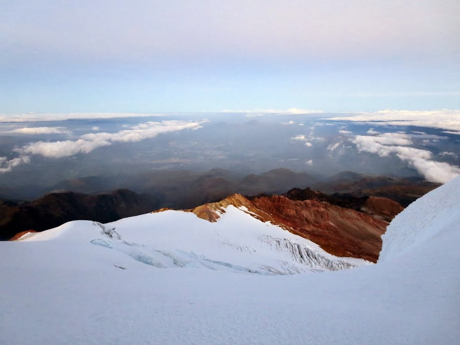

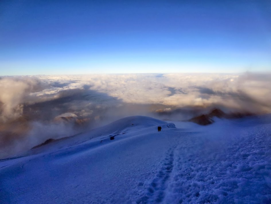
Summit approach


Cayambe, the highest point on the equator known for fickle weather and foul winds, was surprisingly clear with good condition snow for our climb. We lucked out with some views to boot - the mountain's shadow across the hills and our own shadows in the clouds.


The guide was savvy and experienced, leading me to a longer, but fun and gentle scree-ski descent once off the glacier. This saved the tops of my toes.

All in all, our Ecuadorian compromise was fun as a first international trip together and I'd like to go back for the other volcanoes with more time. Yes, the people were friendly and the New Years' traditions were interesting. The peaks were unique and the views were worthy. However, the expense, guide situation, and lack of difficulty on the trade routes might steer me towards another Peru trip or perhaps Bolivia next winter.
As an aside, all of my Latin American travel over the past decade has somehow earned me the privilege of extra airport searches, military inspections, and bomb chemical traces at the airports. Fortunately, they switched Steph's and my luggage tags, enabling the successful smuggle of raw sugar cane and candy. The downside being that the military inspectors gave me a few odd looks while going through Steph's bag.
Hostel:
Aleidas' Hostel. $33.40/ night for a private room and bath. Luggage storage between stays, wifi, and breakfast included. Relatively quiet side street in the business sector a 10 minutes' walk from Plaza Foch, the heart of Mariscal Sucre, and a 5 minutes' walk from a supermarket. The hostess does not speak English but is kind. The walls between rooms certainly aren't soundproof.
Food:
Typically $10-16/meal in the Mariscal Sucre, downtown Quito area. $4-8/meal otherwise. Considering the entrees, costs average around half what they would be in the US.
Lo Nuestro (5/5, $10-14, food was fantastic, interesting wall pictures). Tried churrasco, filet mignon, dates and cheese.
Achiote (4/5, $10-16, the owner was generous, providing us with free wine, appetizers and preparing a table even though we didn't have a reservation on New Year's eve, but one waiter was rude and pushy. My food was okay and slightly overdone, Stephanie enjoyed hers much more than I did; she has always been the better judge of food). Tried fritadas (out of other dishes) and shrimp in garlic sauce.
Magic Bean (3/5, $10-16, overpriced standard food catering to tourists). Tried trout and garlic butter shrimp. Mediocre quality but a liter of $3 pilsner added to the meal immensely.
Mama Corinda (5/5, $9-15, good Ecuadorian food). Tried lomo fine and churrasco.
Fried Banana (5/5, $4-10, great food at a reasonable price downtown). Tried avocado soup, salad, shrimp, desserts.
BBQ and Co, Plaza Foch (2/5, $9-15, overpriced crap). Tried a selection of sandwiches.
Other: Local restaurants in Banos, Cayambe, and the Quito suburbs. Churrasco (steak and fried eggs), cuy (guinea pig), pork/chicken/beef with rice common.
Stay away from the fast food chicken places.
|


