Download Agreement, Release, and Acknowledgement of Risk:
You (the person requesting this file download) fully understand mountain climbing ("Activity") involves risks and dangers of serious bodily injury, including permanent disability, paralysis, and death ("Risks") and you fully accept and assume all such risks and all responsibility for losses, costs, and damages you incur as a result of your participation in this Activity.
You acknowledge that information in the file you have chosen to download may not be accurate and may contain errors. You agree to assume all risks when using this information and agree to release and discharge 14ers.com, 14ers Inc. and the author(s) of such information (collectively, the "Released Parties").
You hereby discharge the Released Parties from all damages, actions, claims and liabilities of any nature, specifically including, but not limited to, damages, actions, claims and liabilities arising from or related to the negligence of the Released Parties. You further agree to indemnify, hold harmless and defend 14ers.com, 14ers Inc. and each of the other Released Parties from and against any loss, damage, liability and expense, including costs and attorney fees, incurred by 14ers.com, 14ers Inc. or any of the other Released Parties as a result of you using information provided on the 14ers.com or 14ers Inc. websites.
You have read this agreement, fully understand its terms and intend it to be a complete and unconditional release of all liability to the greatest extent allowed by law and agree that if any portion of this agreement is held to be invalid the balance, notwithstanding, shall continue in full force and effect.
By clicking "OK" you agree to these terms. If you DO NOT agree, click "Cancel"...
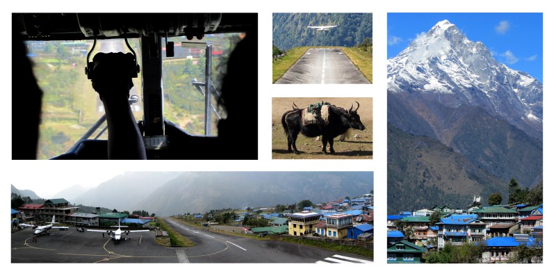
As our Twin Otter dove toward the small strip of asphalt on a 9,300-foot precipice, I immediately understood why the Lukla Airport has been dubbed the most dangerous airport in the world. The steeply sloped runway (to aid landings and take-offs) is only 65 feet wide and about 1,500 feet long - barely larger than an aircraft carrier - and pilots get just one chance to land and one chance to take off.
Here are some video clips I took flying into and out of the Lukla Airport (aka Tenzing-Hillary Airport):
Since 2004, there have been about seven crashes with more than 70 fatalities. So, in an attempt to make things safer, the airlines that fly to Lukla have become stricter with baggage weight limits.
This is what I learned after traveling halfway around the world (after spending an unplanned night and a full day in Guangzhou, China, due to a missed connecting flight). Because of the weight restrictions, Prakash, our Mountain Monarch guide, told us that we would only be allowed to have one 10-kilo (22 lbs.) duffel and one 5-kilo (11 lbs.) backpack each. This was half as much as we were originally told.
Adding to the stress of trying to whittle down all of our climbing gear, clothes, toiletries and simple luxuries for this two-and-a-half-week, tent-based climb, it was midnight, we were exhausted from traveling for two days, and our flight to Lukla was set to leave first thing in the morning. On our journey to the summit, I expected peripheral challenges, but I didn't expect so many right in the beginning.
Most treks and climbs in the Everest region begin in Lukla, and most trekkers and climbers fly here from Kathmandu, which saves a 12-hour bus ride and a week-long trek (each way).
When I first read our trekking itinerary back at home, while sipping a beer on the couch, it didn't look so tough. I figured we'd be hiking slowly, and most elevation gains from one day to the next were only a couple thousand feet. But I figured wrong. In reality, we hiked a bit faster than I anticipated, and there were many significant elevation gains and losses all the way to Base Camp. Locals euphemistically call these ups and downs "Nepali Flat."
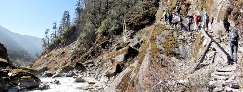
On our first day of hiking, shortly after our exhilarating airplane landing, we headed south out of Lukla. Right off the bat, we got a big introduction to Nepali Flat. By the end of the day, we probably gained more than a couple thousand feet and we hiked close to 10 miles.
And it didn't end there. Every day over the next two weeks, we gained even more elevation and we covered more miles. We averaged about 6 hours of hiking each day, not including breaks.
But our bodies adapted quickly, and as the days passed on, we continued to appreciate the exotic views and the quaint villages that we passed through.
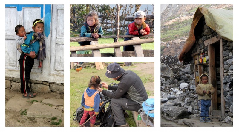
Witnessing the day-to-day life of the villagers was especially interesting, and it seemed like they still live just as they did before Nepal opened its borders to the world in 1950. As I learned, many different ethnic groups make up the population, and it's a very traditional and unspoiled culture with heavy religious overtones everywhere you go.
In Kathmandu it's mainly Hindu, but in the mountains Buddhism reigns. As we trekked, we encountered many prayer-flag poles and Mani walls adorned with stone tablets inscribed with the Tibetan Buddhism prayer, "Om mani padme hum." Of course, we followed the Buddhist doctrine by always passing them on the left side, in a clockwise fashion. Or at least the ones we noticed.
The circuitous route we took to Mera Peak is one of the less-popular trekking routes in the Everest region. According to our guide Prakash, who grew up in Lukla, only about 10 to 15 groups take this route each year. This is probably why we got so many curious looks from local children and adults as we passed through their villages.
The children, by the way, were charmingly adorable. They often greeted us by saying Namaste, as they bowed and pressed their little palms together. It was enough to make your heart melt.
In case you're not familiar with the word Namaste, it is the common greeting in Nepal (as well as some other countries), but it goes a bit deeper than a simple hello. In short, it is an acknowledgement of the soul in one by the soul in another, and it can be interpreted as "I bow to you."
On one memorable occasion, Colin, a birdwatcher from England, shared his binoculars with a child we came across. Based on the child's reaction, it was his first time looking through binoculars, and it was amazing to see his face light up as he peered through them. After he looked across the valley for a bit, he gently passed them back to Colin and, in perfect English, he said, "Thank you."
On another occasion, Jen bought three Snickers bars and a pack of cookies from some girls on the trail for 500 Nepalese Rupees (equal to about $5 USD), and the girl just couldn't contain her excitement. After watching her follow us down the trail to a nearby village, we watched her run to her mother with a massive smile on her face and her tongue rolling across her lips. Considering that the average Nepali only earns about $1.25 per day, we realized why she was so excited.
That afternoon, while taking a break at 10,000 feet, our English friends taught us how to play Cricket.
As much fun as we were having, some of the daily routines (i.e., hiking on endlessly rocky trails, sleeping in a tent every night, eating strange food, pooping over holes, and going forever without a shower) were becoming mentally and physically challenging.
Fortunately, we had a good group of people to hike with, and it was an interesting mix of international folk - two Austrians, two Germans, two Australians, two English and one Malaysian. Jen and I had lots of fun getting to know them, and we enjoyed talking with them about everything from jobs to families, food to beer, and music to movies. And mountain climbing, of course.
Our acclimatization regimen was fairly conservative, which was good because most of us came from sea-level homes. Over the first few nights we never slept higher than 10,000 feet. But after that, our sleeping level slowly moved upward. And on some days we climbed even higher, before hiking back down to camp.
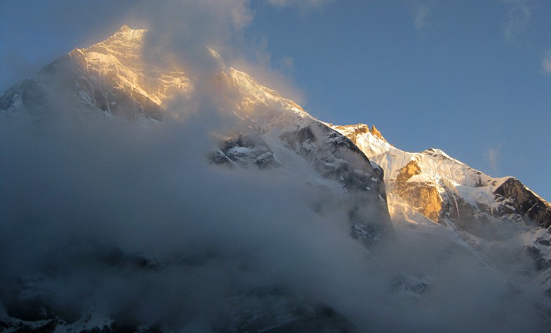
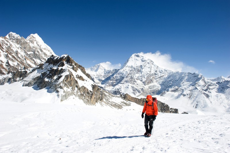
Our first view of Mera Peak:
In the beginning of our trek I kept a journal of our route, but I quickly found it to be an exercise in frustration, as our route itinerary conflicted with reality. Adding confusion to the situation, many villages have multiple names (Tangnag / Tangnang / Thangnak, for example), and the ones that don't have multiple spellings and/or misspellings. To add even more confusion, not long ago, one village was literally wiped away when a glacial moraine broke, sending a massive amount of water, ice and earth down valley. A new village has since popped up, named (or renamed) Kote (also Khote and Kothe), but I don't think it appears in the correct location on maps.
I didn't get hung up on our route specifics, though. I just went with the flow and tried to enjoy our long and complicated pathway to fulfill our dream of climbing above the arbitrary 20,000-foot level, as well as Jen's longtime dream of trekking in Nepal.
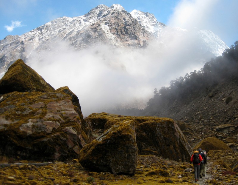
As the days passed by, the terrain slowly changed from jungle forests and mountains carpeted in 32 different varieties of rhododendron trees (which, unfortunately, were not in bloom) to rock and snow.
Jen, lead guide Prakash, and assistant guides Lhakpa Sherpa (who has summitted Everest twice) and Arjun:
Temperatures, meanwhile, swung greatly from blistering heat to freezing cold, and we even had to contend with a bit of rain and snow on a couple days. All of the average temperature ranges we read online and in books were wrong. Every day was both much hotter and much colder than we anticipated, and moisture management was difficult.
In the village of Khare, I turned 40 at 16,400 feet, which is higher than Mont Blanc, the tallest mountain in the Alps. While hanging out by the heater in the teahouse, Colin from England stood up and said some kind words, and then everyone sang happy birthday to me. Then, our cook surprised me with a birthday cake, which we shared with everyone in the room. I was blown away by the generosity of everyone and it was a really cool experience. Even some Russians and Germans from other groups wished me a happy birthday. It was the best 40th birthday I have ever had.
Khare:
Before moving on to higher ground, Wong from Malaysia had finally had enough of the rough trekking and high altitude, so she decided to turn back. She had that "zombie" look I've seen on so many sick people at high altitudes, so I thought she made a good decision. The next morning, we waved her goodbye as we pushed on to Base Camp.
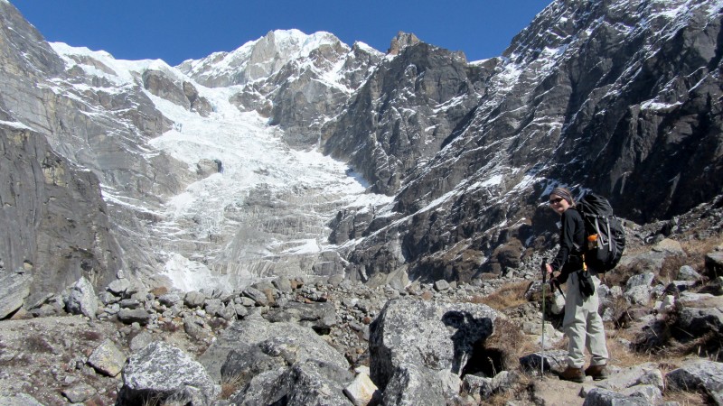
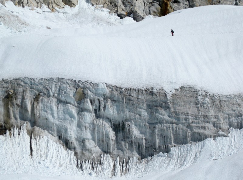
The snow hike to Base Camp was steep and icy, and it was highlighted with occasional avalanches that we could see and hear on the steep rock walls thousands of feet above us.
(Photo by Moritz.)
Everyone in our group seemed to be in good spirits. The hardened climbers we met on their way down the mountain, however, weren't so cheery. Based on the random polling we did, recent summit successes were only about 10 percent.
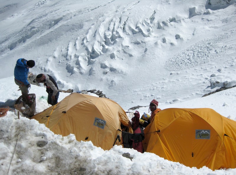
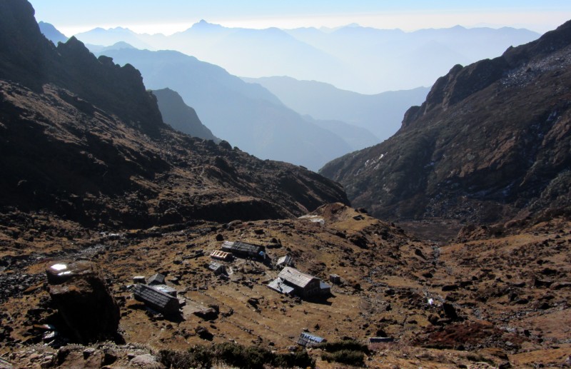
As we arrived at Base Camp at about 17,500 feet, I thought about the misfortune of the previous Mountain Monarch group, which had attempted Mera Peak just a week or two before us. They had made it to High Camp at 19,000 feet, just above Base Camp, but they got caught in a snowstorm that dumped about 7 feet of snow on them. Their situation became so dire that they ditched their tents and tried to retreat back down to Khare. But on their descent they lost their way and ended up having to dig a snow cave for shelter. After spending at least 36 hours in the snow cave, they were finally rescued by helicopter. Everyone made it out OK, though one lady had to be treated for frostbite.
Base Camp, with Mera Peak in the background:
That evening I could hear a cacophony of coughs from all the tents. Most of us had the "Khumbu Cough," which is a dry, persistent cough commonly experienced by climbers in this region. This cough is caused by the low humidity, cold temperatures, high altitude and overexertion, which culminates in an increased breathing rate that exposes the lungs to an excessive amount of cold, dry air.
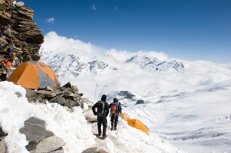
On the following day, the hike to High Camp (approximately 19,000 feet, close to the height of Mt. Kilimanjaro), above Mera La (the pass), was unbelievably windy and cold.
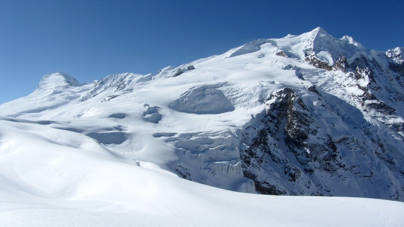
Mera La (the pass) and Mera Peak:
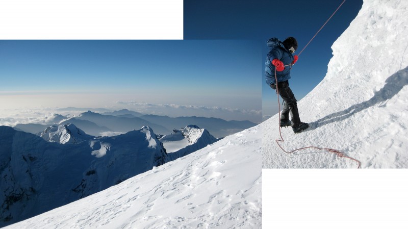
Me ascending the cold and windy slope (the two peaks behind me with snow blowing off their summits are Makalu and Chamlang):
(Photo by Moritz.)
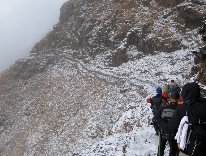
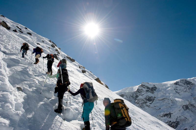
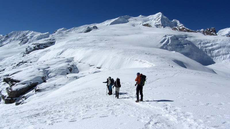
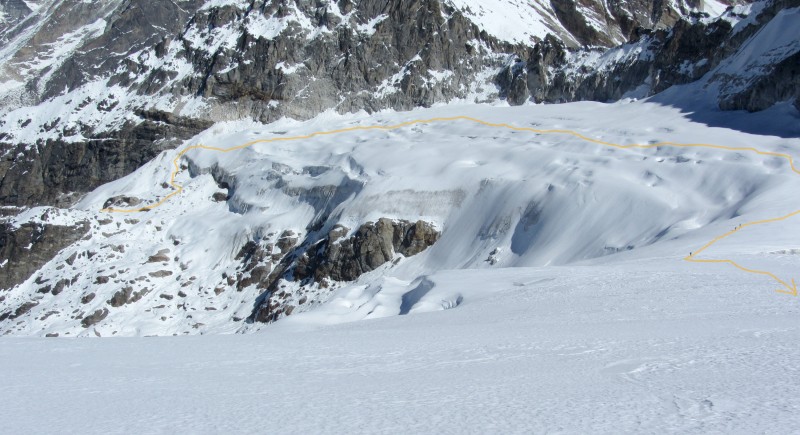
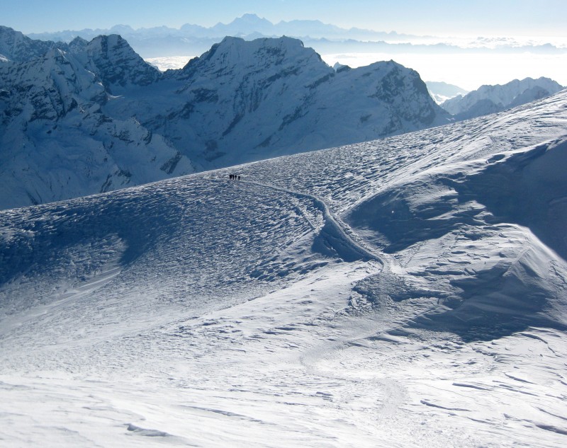
The route from Base Camp to Mera La (the pass), on the way to High Camp (climbers can be seen):
Aside from the spectacular views, High Camp was a miserable place. It was a minefield of frozen pee and poo popsickles, wedged between a crumbling wall of rock and an insanely dangerous cliff that plunged at least a thousand feet directly down onto a glacier. Hell Camp would be a better name.
(Photo by Moritz.)
While prepping our packs for our middle-of-the-night summit bid, Jen found a full bottle of water that she had been unknowingly carrying around for the previous two weeks. The thought of her carrying all that unnecessary weight - all the way up to 19,000 feet - made us both laugh hysterically.
Our emotions took a quick U-turn when we heard the wind begin to strengthen. Strong gusts whipped our tent and peppered it with ice chunks.
Then, just as the sun was beginning to set, a particularly strong gust of wind violently thrashed our tent, causing it to completely collapse on top of us. Tent poles snapped like toothpicks and the roof ripped open in two places. It also began to lift up from the bottom. Fearing it would blow away if we got out, we yelled for help while trying to hold it down with the weight of our bodies. It took a few tense moments for someone to finally hear our voices in the high wind, and then they rushed over to hold down our tent while we quickly gathered up our gear.
Prakash told us to use his tent, and that he'd use the kitchen tent, but his tent was precariously perched right at the edge of the icy abyss.
"That doesn't look very safe," I yelled to him, while shivering in the wind and clutching our sleeping bags so that they wouldn't blow away.
"You will be fine. There's no wind over here," he assured us.
To ease my concerns, Lhakpa, one of the assistant guides, began reinforcing the tent with cords and boulders. He tied one cord so tight that it tore the cord loop off the tent.
I wasn't happy about sleeping in that death trap, but my only other option was hypothermia.
With a Naglene bottle of hot water at my feet in my negative-20-degree sleeping bag, it took at least an hour before my body finally warmed back up. I tried to sleep, but the wind began whipping again, and I cursed Prakash's name.
To make matters worse, my Khumbu Cough had morphed into a full-blown cold. Jen had already been sick for days, so I didn't get any sympathy from her.
So many things were going wrong that I didn't think we'd make it to the top of Mera, let alone achieve our goal of climbing above 20,000 feet.
With less than an hour of sleep under our belts, our guides woke us up at 1 a.m. Two eggs, a half bowl of porridge and a cup of tea later, we began to suit up for our summit bid. It seemed like it took an eternity for me to put on my softshell pants, gaiters, hardshell pants, plastic boots, crampons, harness and all my upper layers.
As we roped up into two teams, we learned that two more people in our group were throwing in the towel. So now our group of 11 was down to 8.
At about 2:20 a.m., we began our ascent up the icy slope. Wind gusts were strong enough to throw us off balance, and the blowing snow made for limited visibility.
Roughly 30 minutes into the climb, we caught up with the first rope team, and they had already lost the boot-packed trail. The high winds had obscured it with blowing snow, and the snow was so fine that when we walked in it we postholed up to our knees.
As our rope team's guide, Lhakpa, scanned his headlamp across the sastrugi-covered slope, I thought our climb had finally come to an end.
If we turned back in the dark, I worried, we could easily lose our way back to High Camp, especially due to the fact that our tracks were being blown away almost immediately behind us. But if we could just continue our upward progress, I figured, the exertion would keep us warm. And once the sun rose, I knew we'd warm up even further. Adding hope to the situation, I could see stars above us as we climbed, so if we could just make it until sunrise, I knew it would be clear enough for us to find our way back down, if needed.
I'm not sure of the exact temperature, but it was extremely cold. To give you an idea, this was the first time in my climbing career that I have ever climbed UP a mountain with my down jacket on. The thin, oxygen-deprived air exacerbated my cold, as my thick blood struggled to make it to the thin veins in my limbs. I wiggled my toes and stomped my feet into the snow, in an attempt to warm them up, but neither seemed to work.
Fortunately, after a good amount of searching and a pinch of luck, Lhakpa finally found the boot-packed snow. And then we continued our slow march up the mountain.
At one point, I really got the sense that we were venturing into an area where humans shouldn't be. At 20,000 feet, there is roughly half the oxygen content in the air, compared to sea level. And if you were able to fly from sea level to 20,000 feet without being acclimatized, you would lose consciousness in a matter of minutes, with death following soon thereafter.
The thin air was definitely noticeable, and it took a good amount of concentration to get my breathing under control. I eventually found a good rhythm of two quick inhales and two quick exhales with each step.
Every 15 minutes or so, we briefly stopped to catch our breath and sip water. I had to punch through a layer of ice in my Nalgene bottle to get to the water.
My legs were on cruise control and seemed to be doing just fine, but my mind was somewhat punch drunk. My eyelids felt insanely heavy, and I felt so exhausted that I just wanted to fall over and take a nap.
Focusing on the simple tasks at hand - continuing to put one foot in front of the other, rope management, keeping my balance and not tripping on my crampon spikes - required a surprising amount of brain power. But in some twisted way, I kind of relished the psychedelic-esque challenge.
Jen, who was tied to the rope in front of me, was also struggling, though I didn't know it at the time because I couldn't hear her in the wind. At one point she told Lhakpa that she wanted to turn around because she was completely exhausted, but he told her that we were very close to the top, so she decided to suck it up and push on. Little did she know, we still had a good two hours of climbing ahead of us.
When a beautiful sunrise began to spread across the horizon, I felt my energy improving. That was also about the time we could see the summit block for the first time. And when we finally made it to the base of that final pitch, I knew we were home free.
Once Lhakpa set up a fixed line, we took turns climbing the nearly vertical wall of ice with jumars (rope clamps that move freely up a rope, but lock when downward pressure is applied).
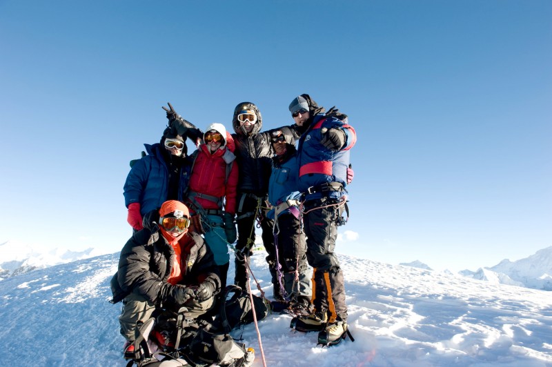
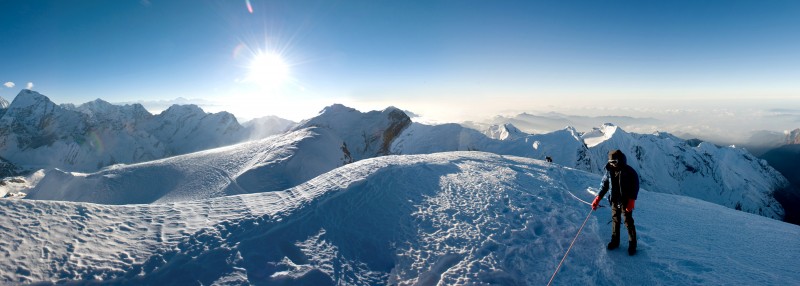
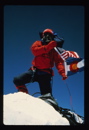
Just before 7 a.m., we gained Mera Peak's central summit (6,461 meters / 21,197 feet), and it felt wonderful.
Even though we had spent two weeks of trekking, acclimatizing and climbing to reach this airy perch, we didn't spend more than five minutes up there. It was an amazing five minutes, though, and I will vividly remember it for the rest of my life.
Summit pan with Jen, photo taken by Moritz:
(Photo by Moritz.)
I was so caught up in the moment that I almost forgot to take photos. But then, when I tried to take some photos, I couldn't get any of my three cameras I brought to even turn on because they were frozen. I stuffed one of them into a pocket for a moment, warming it up just enough to get it to work for a few pictures before dying on me again. Fortunately, others were there to take photos, too.
Me and Jen, with Everest, Lhotse, etc. behind us:
(Photo by Ross, I think.)
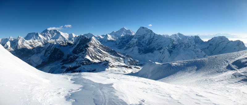
Among the world's 14 peaks over 8,000 meters, the highest mountains in the world, eight are in Nepal (Everest, Kanchenjunga, Lhotse, Makalu, Cho Oyu, Dhaulagiri, Manaslu and Annapurna), and from the summit of Mera Peak, we could see five of them (Kanchenjunga, Makalu, Cho Oyu, Lhotse and Everest). The view was surreal, and it was difficult to drink it all in - let alone capture it on digital film.
(Photo by Moritz.)
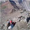
Jen descending to the bottom of the summit block:
After rappelling down from the summit, I managed to get one of my other cameras to work just long enough to take some panoramas (click to enlarge).
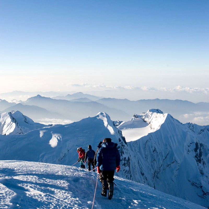
The other members of our group making their way up behind us:
Soon after starting back down, we passed the other rope team in our group, as they were still working their way to the summit. As we walked by, we exchanged words of encouragement and congratulations, though they were mostly unintelligible.
Looking back at the second rope team as they near the final pitch up the summit block:
After descending more than 4,600 feet, we were finally able to rest in Khare. While hanging out in the teahouse, we met a German couple trying to arrange for a helicopter rescue. They had both summitted the day before, but the woman ended up getting frostbite on her fingertips.
Rescue chopper on its way to pick up the Germans:
When Ray, a surgeon from Australia who was in the second rope team of our group, made it back down to Khare, he offered to examine the woman's fingers. After pin pricking the tip of one of her fingers and seeing blood, he told her she should be OK, as long as she kept her fingers warm and got down to a lower elevation soon.
Ironically, as Ray was examining the woman, he noticed some frostbite on his own finger. Two days later, he decided to take the $4,000 helicopter ride himself.
Normally, after you summit a mountain, you just hike all the way back down. But for us, we still had a few days of tough hiking back to Lukla, and it included more than 5,000 total feet of gain and a good 20 to 30 miles of distance. We hiked through some great scenery and we had some great views, though.
After making it back down to Kote, I took this pic of fresh meat ... and later that evening we ate it in the form of yak burgers:
Regardless of which way you leave Kote, all ways go up. It was a tough hike out of there, and my cold made it seem even tougher. My lungs were at about 50-percent capacity, my head was congested, my nose was a snot factory, and my non-productive cough just wouldn't quit.
Adding insult to injury, our last day of hiking - our 16th day of continuously trekking and climbing - required about 1,500 feet of gain, making it over an icy pass, and then a long, 6,000-foot descent all the way down to Lukla.
Saying goodbye to our final camp:
Reaching Lukla was a huge relief, and it was hard to believe our long journey was finally over.
That evening, after tipping our guides and porters and buying them a few cases of beer, we celebrated with lots of drinking and some really bad dancing.
It should be noted that the porters are the true backbone of any expedition. Most of them carry around 80 pounds, and according to our guide, some carry up to 200 pounds! Without them, few would be able to climb anything in Nepal. Even the "alpine style" groups that do not use porters rely on teahouses, and the teahouses are supported by porters.
In my relaxed state, with a belly full of Everest beer and a brain full of oxygen, I finally had a chance to reflect on our achievements of gaining the summit and finally breaking above that 20,000-foot plane. And those reflections were awesome. But the real icing on the cake was witnessing the Nepalese culture firsthand and having the opportunity to meet so many interesting people - not only from Nepal, but also from England, Australia, Austria, Germany and Malaysia.
Oh, and did I mention that we got a foot up in Rum Doodle?
###
For those interested, I thought I'd also post some random photos that I took over a few days in Kathmandu:
And here's an aerial of Everest that I took on our flight home:
Thumbnails for uploaded photos (click to open slideshow):
for posting all of the cultural pictures. This is a place I have wanted to go for a long time. That picture of the women with all of the vegetables might be my favorite. Great trip report and congratulations on your summit!
What a wonderful trip you and Jen were able to do, Aubrey! I so enjoyed reading it and all the pictures. Trip of a lifetime for sure to a fantastic part of our world. I love that they call Mera, Island, Lobuche, etc all ”trekking” peaks. Anywhere else in the world - not so much, but I guess when you have 8000ers knocking on your back door, they can be considered as such. Great job on nabbing that tough summit as well.
Absolutely fascinating report. What a huge accomplishment and incredible experience for both of you. Some of these photos just took my breath away, the scale is so unreal.
Your descriptions of the physical and mental struggles nearing the summit were so vivid... helps me at least begin to imagine what that must feel like. Sounds pretty darn miserable, to be honest! But obviously the achievement and experience would be worth it.
Congrats to you and Jenn. Thanks for sharing this great story with us. And Happy B-Day, Aubrey!
Congrats on an amazing and memorable trip, birthday celebration and achievement. Many, many great pics. Thanks for taking the time and effort to put this TR together!
It is a pleasure to read!
Wow, wicked jealous of yours and Jen's adventure. You picked one heck of a cool way to celebrate your 40th birthday. Great to see you two still living the dream and taking on these adventures together. Thanks for posting an awesome report with even better pictures.
Great job on Mera! Nepal is such an awesome country - and it's world class mountains almost play second fiddle to it's incredible people. Thank you for acknowledging the hard work of the porters - they are all too frequently ignored as clients take all the glory for their efforts.
Caution: The information contained in this report may not be accurate and should not be the only resource used in preparation for your climb. Failure to have the necessary experience, physical conditioning, supplies or equipment can result in injury or death. 14ers.com and the author(s) of this report provide no warranties, either express or implied, that the information provided is accurate or reliable. By using the information provided, you agree to indemnify and hold harmless 14ers.com and the report author(s) with respect to any claims and demands against them, including any attorney fees and expenses. Please read the 14ers.com Safety and Disclaimer pages for more information.
Please respect private property: 14ers.com supports the rights of private landowners to determine how and by whom their land will be used. In Colorado, it is your responsibility to determine if land is private and to obtain the appropriate permission before entering the property.