| Report Type | Full |
| Peak(s) |
Longs Peak - 14,259 feet |
| Date Posted | 10/11/2013 |
| Date Climbed | 08/19/2013 |
| Author | Lville |
| Longs Keyhole - Just A Little Bit Psycho |
|---|
|
Introduction - Just a little bit Psycho The phone rang. It was my Mother. "Norman, as you know, my birthday is approaching, and I need you to do something very special for me." "What is that Mother?" "You must climb Longs Peak". "Yes Mother. Is there anything else you need me to do Mother?" "Yes, Norman. You must also write a trip report about your experiences. You must do this for the benefit of those others who are hearing conflicting voices in their heads saying "Go", "Don't Go", "Go", "Don't Go" . " "Of course Mother". "Oh, and don't forget to write it in excruciating detail. Plenty of parenthetical thoughts would be good as well". "Whatever you say Mother". When your name is Norman (even if you go by "Norm") and your Mother asks you to do something, you don't question it, you just do it ... My wife couldn't remember hearing the phone ring ... August 18 - Morning of ... sort of I woke up on Sunday morning August 18, 2013 and gingerly pulled myself out of bed, one limb at a time. Like every day, it requires a few seconds to make sure the creaky 51-year old joints are fully functioning. But this wasn't like every day. This was the day that I was going to hike (or "climb" as the literature correctly points out) Longs Peak. Technically, this wasn't the actual day at all. Rather this was the day before the night when my arduous eighteen hour journey would begin. And it was the day that I had eagerly been anticipating to the point of obsession for several weeks. I would soon finish packing up, pick up my brother-in-law Phil at the airport, and figure out how to get what little rest we could before hitting the road by 1:00 AM from Louisville, and arriving at the Longs trailhead at 2:15 AM. The careful reader has already spotted a flaw in the plan, which is that Phil was "flying" in on the day of the hike, from Phoenix, AZ no less - at 1500 feet. I had debated long and hard on whether I would hike alone or get a partner (a cardinal sin of course - hiking alone - but for the fact that you're *not* alone on the Keyhole route in August). But Phil had previously expressed an interest in climbing Longs, was no stranger to long hikes, and we felt that he could do it. Unfortunately, his schedule did not allow him much time to acclimate. Phil and I are the same age. I'm actually in pretty decent shape for a middle-aged guy, but Phil is a triathlete, runs half-marathons, flew planes in the military. You get the picture. We're both acquainted with the need to acclimate at high altitude but I guess they have 12,500 foot summits in Arizona and Phil had been to some of them. Additionally, he had recently hiked the Grand Canyon, covering 23 miles and 7,000 feet of elevation gain, albeit at much lower elevation. We knew it wouldn't be easy, but just hoped that that would all translate. Besides, we could always turn back. I was delighted that he accepted the challenge with enthusiasm and I would have good company on the trail. I mentioned an obsession with Longs over the last few weeks, but this was just the culmination of a much longer term fascination that had recently intensified. For almost 20 years, I've gazed up at Longs Peak on a daily basis, and always felt that I had to climb it. Prior to this summer, I had summited half a dozen mostly easy 14ers, and I always looked up at Longs and said that I would attempt it eventually after getting in better shape and working up to it. But I knew that I wasn't getting any younger, and doubt was beginning to creep in. The time was now. Preparation I knew quite a bit about Longs Peak already, but in the weeks leading up to the hike, I devoured almost every July/August/September Longs Keyhole trip report on "14ers.com". I wasn't interested in climbing outside of that three-month window and I think that mid to late August is optimal with regard to conditions. July may have snow or attendant wet meltoff from the previous winter, and September is likely to have new snow/ice. For me, each report - long or short - was like reading the next chapter in a good mystery (I finally knew what my Ipad was for) as I looked for clues that would help me get mentally and physically prepared for this trip. I knew from the reports that, for many people, this climb is a once-in-a-lifetime event. Like most I guess, getting in shape goes in fits and starts. I will generally start thinking about the Bolder Boulder 10K at the first of the year and then set the goal to make diet and fitness a priority up until Memorial Day in preparation for the run. This year, ironically, I wasn't ready for the Bolder Boulder but I continued my exercise regimen into August, spurred on by the idea that maybe I'd get some hikes in over the summer and then *maybe* consider Longs. I decided early on in the season that I wanted to make this summer count. My wife and I celebrated our 25th wedding anniversary and I visited my 30th major league baseball park with my wife and sons to complete the full circuit. And while we're dealing in round numbers, why not get to ten 14ers? No commitments or circled dates at that point, but Longs was in the back of my mind. So over the six weeks preceding my Longs attempt, I worked up slowly on the hiking front: Flatirons, Bear Peak, three relatively easy 14ers. My wife and youngest son summited their first 14ers as they took turns accompanying me on Democrat, Torreys, and Uncompahgre to bring my total to nine. Then, to top it off, my wife and I hiked up to Chasm Lake under the Longs diamond so I could get the lay of the land in the daylight - and log another 9.5 miles. (I strongly recommend this hike whether you're in training or not - and it's wrong that we waited 19 years to do it). At this point I was feeling lots of excitement and much more confidence about the upcoming climb and it was pretty much all I could think about. Other preparations of note: -in addition to the aforementioned reading of everyone's trip reports, I started watching YouTube videos on the climb. -I read "The Longs Peak Experience" (Donahue, 1992): I highly recommend this book. It's a quick read and full of info and inspiration. It was written in a quaint, conversational style. $10 I think. -attended an REI talk on Longs put on by RMNP rangers. -I constantly checked the weather report for Longs on 14ers.com. You don't necessarily have to do all these things but, understand, I was still trying to talk myself into attempting the climb. It's a mistake to not understand this mountain and do what is required. Many folks have to turn back, get injured, or worse, and I wanted to put myself in the best position possible for success. Supplies -30L Gregory Z30 backpack (2.5 lbs) -trekking poles (I took them with me past the Keyhole and used them extensively on the way down - mostly in the Trough) -4.5 L water (3 L in camelback + 1.5 L water bottles = 9 lbs). I consumed 3.5-4L. -In addition to my synthetic tee shirt and hiking pants: Long sleeve shirt. Sleeveless fleece vest. Light rain jacket. Base layer (OK - long johns). Extra socks. Winter hat. Gloves. (guessing 2-3 lbs total?) -3 lbs food (trail mix, Clif bars, two PBJs, apple) -1-2 lb misc stuff (GPS, first aid, tissue etc) -Ibuprofen. I take it before the hike and more at top if needed. -camera/phone (put it in "airplane" mode so you don't kill the battery) I'm guessing 17-20 lbs or so on my back, and a perfectly sensible list, but it was overkill for the weather we experienced which ended up being pretty mild. I could have skipped the long johns, socks, sleeveless vest, and a bunch of the food. Trail mix and three Clif bars would have worked. Maybe drink from the camelback and stash a water or two in the Boulderfield and hope you can find it undisturbed upon return. I considered iodine and water filters, but did not have experience with either, so just opted to carry the water. I only used the long sleeve briefly in the wind at Granite Pass and the rain jacket was only needed for about 10 mins. And I never used the wool hat. But, still, you should *definitely* have these items because, like Forest Gump says, "you never know what you're going to get"! Gloves are a must. Partly for cold, but mostly for keeping your hands from going raw when you get to the climb. My gloves were fleece (one of them was left at bottom of the Trough - if you found it let me know). I would consider getting tighter fitting gloves for rock grabbing and manipulating the camera/phone. Don't forget your sunscreen. Depart Louisville 1:00 AM - 5400 ft In the week or two prior to the trip, I'd wake up in the middle of the night and imagine myself trying to leave the comfort of my bed for a grueling all day hike, and it was never appealing. However, when the time came, I couldn't have been more jazzed. It felt like Christmas as a child. We had debated whether it made sense to get a hotel room in Estes or pitch a tent at the trailhead, but we eventually just opted for the simple. We would just drive the hour and 15 minutes. As we drove through Lyons, it occurred to me that in each of the several years previous on this night, I would have just a few hours earlier driven through here on my way home to the safety of my bed after the conclusion of the weekend Folks Fest in Lyons. I wondered if that is what I should have been doing this year ... But the drive was kind of fun, especially with Phil's good company. Did I want to begin an epic journey in the middle of the night? Yes! Did I want to amble through a Goblin Forest under a full moon? Sign me up! Did I want to see all the bobbing headlamps coming up the trailhead that I'd been reading about? Check! Did I want to see the alpenglow on the Longs Diamond and the sun rise over the Twin Sisters after four hours of hiking? Yep! And did I want to experience the mystery of forbidden places with names like: "The Ledges", "The Trough", "The Narrows", and "The Homestretch"? Yes, yes, yes, and yes! I was ready. Trailhead - 2:25 AM - 9,400 ft No problem parking on a Monday at 2:15 AM on Aug 19. We spent a few minutes getting organized, turned on the headlamps, and off we went. We kept a steady pace, stopping a few times to make adjustments to back packs. We survived the Goblin Forest. Granite Pass - 5:05 AM - 12,080 ft True to form, it got windier here and we donned an extra layer. There were two headlamps in front of us that would appear and disappear in the night. It was interesting on the way back to see the undulations in the topography that caused it. From Granite Pass, we climbed a few switchbacks, and saw the first faint light in the sky. We came up over the rise that led to the Boulderfield and, off in the distance, there it was, the Keyhole! After all the pictures I had seen, this was as cool as anything I experienced on the hike. I failed to record the time to the Boulderfield, but the start of it is quite different than the finish. Phil and I wondered what all the fuss was about and started calling it the "Pebble Field". But that changed soon enough as we boulder hopped for probably close to an hour, with a steep rise at the end as you arrive at the Keyhole. In retrospect, the 15 miles that I had been dreading (and a new distance record for me) was maybe a blessing in disguise as it meant that the hike to this point really wasn't very steep even though you gain almost 4,000 ft to the Keyhole. We still felt reasonably fresh after about six miles or so. The Keyhole - 6:50 AM - 13,200 ft I was hoping to arrive here at 6:30, but we weren't off by much. After the obligatory visit to the Agnes Vaille hut, this is where the real excitement begins as you peer over into the abyss. I had seen lots of pictures so was somewhat prepared, but Phil commented later that he looked across the valley and thought "Where's the trail?!" We looked over to our left, and the Ledges came into view. It was light enough to see, but this side of the mountain will be shaded for some time to come. I looked across the side of the mountain, and had no idea where the Trough was which was a little intimidating. I noted that, luckily, the high winds that had been described here were almost nonexistent. With that, we dropped down out of the Keyhole, and stepped onto the Ledges. I think Phil was really starting to feel the effects of the altitude, but was soldiering on. The Ledges - 6:50 AM From all the pictures and reports, I had a preconceived notion of what each section would be like. The Ledges were tougher than I was expecting. I think this was because it was a) the first section encountered b) it was longer than I thought it would be and I wasn't sure where the end was c) I wasn't expecting to be doing hard work at this point d) Phil was feeling the altitude and e) it was kind of scary. The painted-on bullseyes marking the trail were very clear, but there were places where we would look at the next bullseye and think "How are we supposed to get there? Oh geez, I think we have to climb over this thing and than up across and over that thing". It was all doable, but it required much more climbing and arm work than we were expecting. I remember one "V"-shaped section that angled up about ten feet with a very smooth, polished granite surface (a preview of the Homestretch). We really weren't sure how to negotiate it, but with hands, knees, and feet we somehow managed. At this point I'm thinking, "How do so many people do this?" Another issue was that Phil was beginning to feel very sick which probably detracted from our ability to move through here with more enthusiasm. I should have been more in tune to this, but I kept irrationally hoping his condition might improve after some rests. I didn't want to think about turning back which was of course a dangerous attitude. I also remember noting that my left arm was getting very sore and tired. This was from overcompensating and leaning into the mountain on my left. I did not wish to stand straight up or, heaven forbid, lean the other way. I remember thinking that this would even out with my right arm on the way back ... The Trough - 8 AM'ish - 13,240 ft About midway through the Ledges, I could see ahead to what I realized must be the Trough. By the time we arrived there, it was 8 AM, and I started to feel way behind schedule as I had allocated about 2+ hours from Keyhole to Summit and about half that time was gone on the first of four sections. But worse, as we sat at the bottom of the Trough contemplating our predicament, Phil began to get physically ill and announced that he couldn't go on. He had toughed it out to 13,200 and simply had not had enough time to acclimate. Obviously it was a smart decision for him to stop. At this point, my stomach was starting to feel unsettled, but my head was OK, and I wasn't yet at the stopping point. We debated what to do, both of us bummed. Phil said that I could go on and he would wait for a bit presumably for me to get up and back - which was not a good idea - the best cure for altitude sickness is to drop back down. I was feeling pretty guilty about the whole thing, feeling a little sick myself, and not at all sure that I could make it up the Trough as I was becoming a bit sore and lethargic. But I wanted to try. I considered turning back with Phil, but I had invested so much up to this point that I couldn't bear the thought. So I just started moving up the Trough. After a few minutes of climbing, I flagged down a Good Samaritan on his way down and asked him if he would find Phil at the bottom of the Trough and accompany him back to the Keyhole, which he did and this worked out well. Phil later described his condition as a really bad hangover at 13,200 feet with a long way to fall. Just to gain any advantage I could before continuing, I removed from my pack a water bottle or two, an apple, and a PBJ and set them on a rock. And I moved on. The Trough is quite long with 600 feet of elevation gain, and a dog-leg to the right provides a decent mid-way checkpoint. It was a bit overwhelming and difficult, but perhaps because it held less exposure than the Ledges, it seemed easier (as I write several weeks later). Much has been made in other reports about the danger of other climbers kicking rocks loose on this portion, but it wasn't a problem for me on this day. I debated wearing a helmet per advice from some trip reports, but I opted to skip the headgear. That is a calculated risk and obviously could come in handy, but I didn't feel that the risk demanded it. I would guess that perhaps 5-10% of climbers wore helmets. Maybe those are the smartest ones. The trip up the Trough has become a bit of a blur. I remember thinking that I'd just go a little bit farther just to see what was next. In other trip reports, the various authors/photographers had taken many good pictures, but would at times fail to capture key parts of the climb. These omissions were sometimes attributed to "being preoccupied", but *I* was determined to do better. I now understand this. Upon review of my generous cache of pictures after the climb, I was amused to find that I had no shots of the Trough on the ascent - which maybe gives a better indication of what the Trough was like than any pictures could! (Well, and the pictures I did have never quite captured the mountain in the manner that I wanted. Maybe it's just not possible. When you're wiped out, and in a precarious position with time slipping away, getting just the right camera angle takes second priority). Eventually, I found myself at the top of the Trough facing "The Chockstone" - and more discussion is required here as this is the crux of the route. Many of the trip reports noted that the "Chockstone" presented some challenges, but I don't think that justice was done in some of the descriptions. (Note: I looked it up and "Chockstone" appears to be the correct word, though "Chokestone" is perhaps more descriptive as it "chokes" off entry to the Narrows). I spent probably 20-30 minutes standing in front of this ten foot rock trying to figure out how to proceed and many times reaching the conclusion that my climb was over - it was time to turn back and see if I could catch Phil. Some reports said go right, some left. While I debated, I at least put myself to good use attempting to help others up and down while I studied their various strategies. There were quite a few people passing me at this point and folks tend to do what everyone else is doing, so everyone went right. I at least went around to the left to see what options were available, if any, but with no one attempting it, I couldn't figure out how one would go about it. Throughout the entire climb, I would try to figure out what "Plan A" was, then what the consequences of failure would be, and then what might be a viable "Plan B" in the event of said failure. The good news is that Plan A failure here would not be fatal. The bad news is that there was no Plan B. There were a couple of handholds/footholds apparently carved into the rock, but they need a couple more. The "handholds" were not things that you could curl your fingers around and pull - they were just flat surfaces dug a couple of inches into the rock. The rock is not vertical, and the footholds looked decent as long as my hiking boots held traction. If my boot were to slip, I would have to hug the rock with my belly and slide back down five feet or so, banging knees, shins, and elbows on the way, and eventually land back at the ground and just hope that the first ankle to hit would not get sprained or worse. A severely sprained ankle could spell doom up here. I was ready to give it up, but with the encouragement of others (Rich and Mike I think were two of the helpful cheerleaders), I decided I had to give it a go. Besides, I couldn't recall a single trip report where the Chockstone turned someone away. This is another segment where I wish I had some pictures but, as mentioned previously, that was the last thing on my mind. So I leaned into the rock, grabbed on as best I could, exchanged handholds for footholds, and scrambled on up to the top in maybe five moves. Whew! Made it! OK, in retrospect, and to calm the fears of those readers remaining who think this is worse than it is, it was kind of fun and, while difficult, my fears were primarily from inexperience. I, uh, may have been being a bit of a weenie ... You'll just have to see for yourself ... The Narrows - 9:30'ish - 13,900 ft Fresh off of my victory over the Chockstone, I was feeling optimistic and downright celebratory, but now I was looking at what I expected to be the most frightful part of the trip - the dreaded "Narrows". It did not disappoint as, like the Ledges, you look across the mountainside wondering where exactly the "path" is and where it ends, except that the drop off was much more sheer. A slip here would have very dire consequences. However, I'm happy to say that for some reason, I felt like this was easier for me than the Ledges. I may have been gaining confidence or it may have been that there was more "stepping" and less "climbing" than on the Ledges, and it was also somewhat shorter. Also, it's important to note that there are only a few places where you only have a two or three foot path. There seemed to always be decent handholds (I kept at least one hand on the mountain at all times) and there were a number of places where the path widened where you could rest and people could pass as necessary. The bullseyes (and people) were plentiful to help guide the way. The Home Stretch - 9:50 AM - 13,950 ft A "home stretch" sometimes implies that the hardest work is over and you can cruise on in. Not so here. It is true that it is probably the shortest of the four segments and you can see your destination from here, but in many ways it is the trickiest of the segments. This is because it is *very* slippery on polished granite, and quite steep with about 300 ft of elevation gain. There are a number of cracks in the rock and a corresponding number of lines that can be taken to the top. People tend to descend in a colorful line, following each other down a preferred route. I've read a lot of conjecture on the slope of the Homestretch - sometimes hearing that it may be as much as a 45 degree angle. Many years ago someone told me that people regularly overestimate how steep a slope is and if you made it up the slope without ropes and handholds, then it almost certainly was not 45 degrees. After viewing lots of pictures and reading reports, I was so curious about the actual slope of this granite slab, that I considered taking a Brunton compass with me in order to measure it, but I did not, perhaps figuring that an apple was more important than a Brunton compass. After ascending and descending, I still cannot say with any certainty. While there are portions of this segment that someone with "sticky" shoes can walk up, hands are required for most of the ascent. I suspect that the actual angle is close to - but not quite 45 degrees. I'll guess close to 40. Probably at least 35. Still plenty steep. I tended to not take a big step unless I could get a nice handhold first. And I can't imagine navigating this segment when wet. On the return, I crab-walked most of the way down, using my backside to good advantage. In any case, I was exhausted by now. My stomach still hurt and I just went about ten feet at a time and rested. One thought that I distinctly remember having on this segment, was that I did not want my wife or sons on this climb. There are enough cracks in the rock that you would probably catch yourself if you slipped. But if you did not, it's a long way down ... It seemed like the Home Stretch went faster than the Trough or the Ledges. With considerable perseverance, I plugged away until the expansive, flat top of Longs Peak lay before me. I had made it! Wahoo! Summit - 10:30'ish - 14,255 ft I was so elated to have made it to the top (tempered by the fact that I knew I had to go back down), that I forgot to record the time. My best guess is 10:30 AM. Almost four hours since leaving the Keyhole. The top was as exactly as described by others. Quite flat and about the size of a couple of football fields. Very unusual for a mountain top. The weather was better than I had hoped. Without much wind, I was comfortable in my tee shirt. Some gathering clouds, but not yet threatening. There were maybe 15 to 20 people at the summit, with more arriving. It felt good to see other folks' jubilance in making it to the top. I looked over to see a blond headed boy raise his arms in victory as he came over the top. He was the youngest that I saw. The primary demographic was 20-something males. Some a little older. In all cases of summiting 14ers, it is my wish to linger at the top - celebrating, chatting, taking pictures, resting, eating, and exploring my surroundings in an attempt to identify other features. But also in all cases, I'm acutely aware of the need to get back down before weather hits. This was a shame on this peak because there was plenty to explore. I walked over to the north edge to peer down over the diamond at Chasm Lake where I had been one week earlier with my wife. I would have liked to walk the periphery of the top to take in the views in all directions, but I felt pressed for time. If you live here or have done any research at all, you know that it's wise to be off a 14er peak by noon. The problem with Longs is that there is no way to make a hasty retreat in the event of adverse weather which is both guaranteed and often swift in arriving. I originally had allotted four hours from Keyhole to top and back, plus a half hour rest at the top, so I had hoped to summit by 9 AM. I was way off on that goal and since I had taken 3.5 hours to ascend, I knew it would take at least 2-3 hours to get back to the Keyhole. Another sobering thought that hit me was - what if I'm the last one off the top? Would anyone wait for me? Would anyone know if something happened to me? This had actually happened on Mt Sneffels (last one off) and it was not a comfortable feeling. It was time to go. It's always good to have a climbing partner, so I looked around to see who I recognized from the trip up. I found a couple of guys whom I'd met earlier and to my relief, they were willing to let me kind of hang with them on the way down (thanks Ethan and Jason!). I took a short head start as I knew that they would catch up with me quickly. This time I did check my clock - 11:05. The Descent The mountain is so popular that of course there were more people still coming up at 11 AM (though I don't think *I* would want that ...), so my concern about being the last one down was unfounded. I don't care what all the pictures suggest or don't suggest or what other folks say about seeing people walking down the Homestretch with "hands in pockets" - I didn't see anyone doing that. If your hands are in your pockets on the Homestretch, it probably means that you have an itch that can't wait. To me, the only way to descend is by crab walking, with butt sliding down the rock and an eye on the next foothold/handhold. Thank goodness it was dry with no immediate threat of rain. To attempt this descent in the rain would be unnerving to me. I came down with a different and improved frame of mind. I had made it! And every move downward was one step closer to relative safety at the Keyhole. I simply divided the descent into the four sections and took one at a time. The Narrows weren't any more fun than they were the first time, but it meant that the Trough was near. The Trough seemed much easier to me on the way down. The Chockstone was less of a challenge because I could see to the bottom of the rock and could therefore "time" any emergency landing. Tedious, yes, but I felt the most secure in the Trough. I will note here that this was the one section where I was very glad to have my trekking poles. I'm not sure I remember anyone else using them past the Keyhole and they are just a hindrance for most of the climb, but I welcomed them now. I think they're great for balance and "testing" the next rock. Happily, near the bottom of the Trough, I was surprised to find my old friends - the PBJ, apple, and waters stacked neatly. I think they had been reassembled by someone - looked kind of like a cairn. By the time I reached the Ledges, everything seemed easier, though I was cognizant of the fact that the Park Rangers had mentioned that most of the Longs accidents seemed to occur on the Ledges on the return trip which I assume had something to do with fatigue, but also folks not following (or unable to see) the bullseyes and heading off to the "false" Keyhole. I knew I had beaten the weather for the most difficult part of the climb, and the crawl through the "V"-shaped feature on the way up was now a slide back down it. And Ethan and Jason were kind enough to keep an eye on me. I started inspecting the side of the mountain for signs of the Keyhole, and eventually it came into view. I reemerged from "the dark side", and it felt great. But there was still work to do - about five hours of it. The initial descent down from the Keyhole into the Boulderfield required some care. And of course at this point, it started to rain - and hail - as the clouds gathered and strengthened. This made sense since it was now 2 PM. "The Longs Peak Experience" listed places to be and not be in the event of lightning (all relative since there are no "good" places to be - apparently the bottom of the Trough is better than the Ledges, etc.) It had listed the Keyhole as one of the primary targets for lightning strikes ("stay on the Ledges and wait for lightning to subside before crossing through the Keyhole"). So I hastily donned my rain jacket and dropped down into the Boulderfield as fast as I safely could. Unfortunately, the Boulderfield was also listed as a bad place to be and it takes about an hour to cross it. But at this point you have no choice. You just keep moving and hope the lightning won't find you. Which is why you want to be much farther along than I was by 2 PM. The good news was that the rain/hail ceased as quickly as it came on and, except for a few thunder claps in the distance, it wouldn't be a problem for the rest of the hike. The rain jacket came off, and I decided to take a break and see if any text messages had come through. Good news, Phil had texted that he was at my truck. I was relieved that he had made it back safely, but had to laugh to myself as he probably figured that I was only an hour or two away. I texted back that I had successfully summited and that I would be a good four hours at least. I then called my wife to tell her I had so far survived, but not to expect us for dinner. I was exhausted and I figured my toe nails would later all come off with my socks. But I felt a sense of calm and deep satisfaction with what I had just accomplished. I knew I had four hours left (five actually), but compared to what I had just endured, this would be easy. Life was good. When I got to tree line, I again wished I had a hiking partner since I figured that having survived all the dangers of the mountain, I would no doubt be eaten by a bear, mountain lion, or hungry marmots sensing my weakened state. A couple of groups passed me and I tried to keep up with them to no avail. My aching limbs just wouldn't move me fast enough. You pass a few parties heading up, but this late in the day, those are folks mostly heading to the Boulderfield to spend the night. Funny, I imagined at one point that maybe Phil would meet me part way up, but I figured that that was the last thing that he'd want to do since I had told him to take the truck to Estes Park if he wanted to. And anyway, like my PBJ sandwich, I had abandoned him on the mountain side. I kept looking for the Goblin Forest campground sign to signal that I was 1.25 miles out or so, when around the bend came Phil. Was I ever glad to see him. He said he had felt pretty sick all of the way down but had recovered in the truck and had been passing time resting and chatting with the rangers. He was pretty chipper now and offered to carry my back pack, trekking poles, or whatever. I figured it was my duty to carry the back pack the final mile and I wasn't about to part with my trekking poles. Trekking poles are the best. But I appreciated him offering. Really, Phil's experience is maybe the most valuable takeaway from the entire report if you're coming from afar. It doesn't matter what kind of shape you're in, the altitude can get to you if you don't have a few days to acclimate. As advertised, the final mile is quite long and each step became painful. But it was the good kind of pain because I was feeling great about my day. Eventually the parking lot appeared and by now it was pretty empty. Many cars had come and gone since we had arrived 17 hours earlier. I rarely let anyone drive my truck - but I forced my keys upon Phil. Our original plan at 1:30 AM as we passed through Lyons on the way up was to stop at Oskar Blues for a celebratory beer after the hike. But now, stopping off somewhere was no longer as appealing. We did pull into a gas station and I sent Phil in for drinks - I was pretty sure that I couldn't get out of the truck and back in again. As we passed through Boulder, I phoned in a pizza to be ready for us when we reached Louisville. The pizza sounded really good and we enjoyed it, but first we stopped for cheeseburgers, just because. Upon arrival home, I drew a hot tub for myself, climbed in and promptly fell asleep (I'm bigger than the tub so drowning isn't likely - but wouldn't that have been unfortunate and ironic). I eventually transferred to the bed, unsure of how I would sleep because my legs ached so badly. After a period of time, I was finally able to drift off to sleep. But then, at some point in the middle of the night my slumber was interrupted by a voice - "Norman, you must climb Longs Peak again next year". Yes Mother. Final Thoughts (I promise) I spent a lot of time thinking about this climb, and all the various trip reports that I had read. The objective items here are that there is a very large mountain that is quite steep at the end, and potentially very dangerous - especially in foul weather and, regardless of how experienced you are, it's a long day. Nothing real profound here, but an individual's view of this journey - whether completed or not - is a matter of perspective that is shaped by a number of factors: -weather conditions -what are your expectations going into it? Just another hike? Intimidating? -how prepared are you? -how cautious of a person are you? -what kind of shape are you in and was there sufficient time to acclimate? -how old are you? -who and how many are in your climbing party? Is there someone experienced in the group? -how experienced are you? Have you made other Class 3 climbs (or better)? Have you climbed Longs before? Have you climbed other 14ers? -if you've climbed it, how recent was it? I find the last item to be kind of tricky and it might influence how people report on it. At the time, I found the climb to more than a little unsettling. Each segment seemed like I was definitely pushing the envelope well past my comfort zone. As I labored up the mountainside with a steep drop below, I wondered if this pursuit was pure folly, and in fact maybe climbing 14ers in general was dumb - period. I certainly didn't want my family up here. But the mind is a funny thing. Phil and I had discussed this before we even set out. How we had had these exhausting experiences to the point of swearing off ever doing them again - only to wake up a day or two later and start planning the next one. Those thoughts are of course not unique. I think a lot of folks have had that experience. So I knew that my trip report, if written immediately, might be quite different than one written weeks later. Taking this into account, I jotted down some notes after the climb, and then let the whole thing settle in for a few weeks so that the report might contain both perspectives. It was tempting to sprinkle my report with more bravado, perhaps providing more comfort for those who have not yet climbed, except that that would be a bit of a departure from the truth. But ... after recuperating (I was sick for the next week possibly from reduced resistance from the climb and lack of sleep, and quite sore for 2-3 days), I pretty much convinced myself that maybe it wasn't as difficult as I first thought, and that I would do it again with my own new perspective. I even considered going back up again two weeks later. I no longer question whether I can do it, and I suspect that the climb will be much less intimidating the next time around, but I want to find that out too. And I want to spend more time enjoying the mountain and view, and less time thinking about my fatigue, soreness, and danger. I don't want to hurry of course, but I want to see if I can cut a 16 hour hike to 14 or 15 hours or less. A lot of time and energy was spent on anxiety, and stopping and contemplating my next move. Additionally, as Longs is generally ranked 15th or so in difficulty of Colorado's 54 'teeners, I feel like I just jumped to the head of the class as 40 of them suddenly came into play. I never expected to do more than ten or 12 (Longs was ten), and now I'm doing the math on how to get 35 to 40 under my belt in a realistic timeframe. If you've done your research and are prepared, you can do this mountain one careful step at a time. But I would strongly caution against driving in to Estes Park, peering up at Long's for the first time and deciding that it would be fun to go up the next day - it probably won't be. I'm very pleased with the fact that I've been to the top of this mountain and scratched it off my bucket list. It was a wonderful experience and well worth the effort, and when I look up at Longs in the late morning, I'm even a bit envious of the stream of people summiting right about then (in the summer ...). And now that some of the excitement has worn off, I think I need another fix. I feel fairly certain that I'll go back. Maybe with Phil! We'll see. On to the pictures (applicable text is *below* the picture) ...  I grabbed a screen capture on my iphone of the topo map from the 14ers.com app. Seemed like a convenient way to carry the topo map.  This was from the previous weekend at Chasm Lake. My wife and I hiked up there to get the "lay of the land" in daylight. Wonderful View of the Diamond up close and personal. Maybe more dramatic if I weren't in it.  I wanted an early morning "Diamond in Alpenglow" of my very own. Unfortunately, I think I had the flash on for all my early pictures which kind of ruined them. This one not too bad though.  The ominous warning sign at beginning of the Boulderfield.  Phil contemplating the remainder of the Boulderfield and the Keyhole.  The Guardian of the Keyhole. Guardian's chin looks a bit unstable but probably good to go for a while. There is quite a rise leading up to the Keyhole that I wasn't expecting. Pick your way carefully through here. Love the orange and blue. Actually, a hike up to the Keyhole is a great day in its own right (and a 13 mile round trip). One approach if you feel a bit uncertain about going to the top is to just plan to hike up to the Keyhole, take in the dramatic views on the other side, check out the Ledges, and turn back. Then come back another day. I would turn back regardless if a) it was past 8 or 9 AM, or b) the weather looked threatening. A quick hiker can get from Keyhole to summit and back in four hours. A slower hiker (like me), somewhat longer. A *lot* of weather can happen in four hours ... 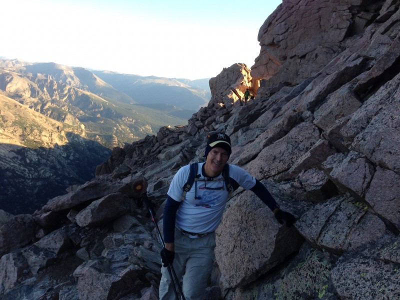 We had just dropped down onto the Ledges. The Keyhole is letting a little sun in.  Looking across the Ledges toward the Trough which is just right of middle.  The two bars drilled into the rock. The lower one is maybe hard to see in the picture. You wouldn't *have* to have these to get over the rock, but they definitely help. This is a section where you do not want to slip. 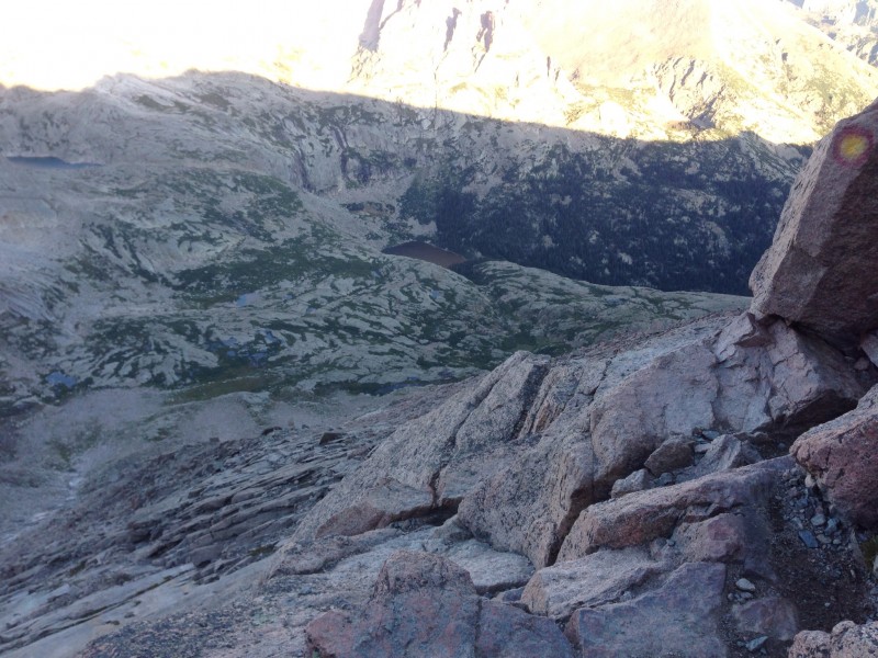 Where you would go if you slipped. Don't slip.  Still the Ledges, looking back toward the Keyhole. I think maybe a person in red in lower right.  I completely forgot to get a picture of the Trough on the way up as I was "preoccupied" as explained in the text. But this is a picture looking up, that I took on the way back down. You can tell from the gathering clouds. Unfortunately, I failed to get a picture of the "Chockstone". Same reason.  A move in the Narrows. Not difficult really. Just may have to use hands and knees.  Looking across the Narrows toward the Home Stretch. This shot tells you a lot about the Narrows. Slipping here is very likely fatal, but there are stretches where there is quite a bit of room.  Looking up the Home Stretch.  At start of Home Stretch looking back at Pagoda with the ice cream scoop taken out of it, presumably by a big heavy chunk of ice to create a glacial cirque. The red sign indicates the bottom of the Home Stretch on the way down - and points the way back to the Keyhole via the Narrows. 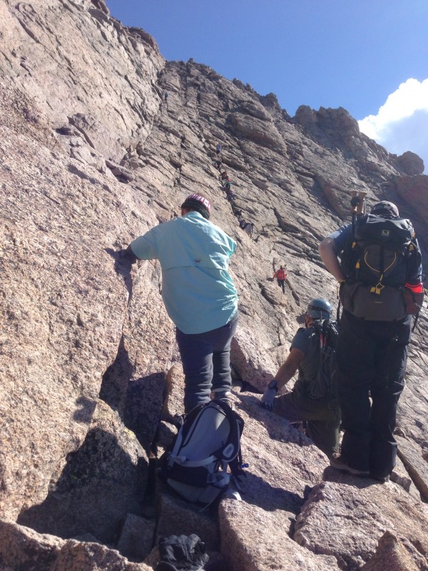 Another shot of the Home Stretch. 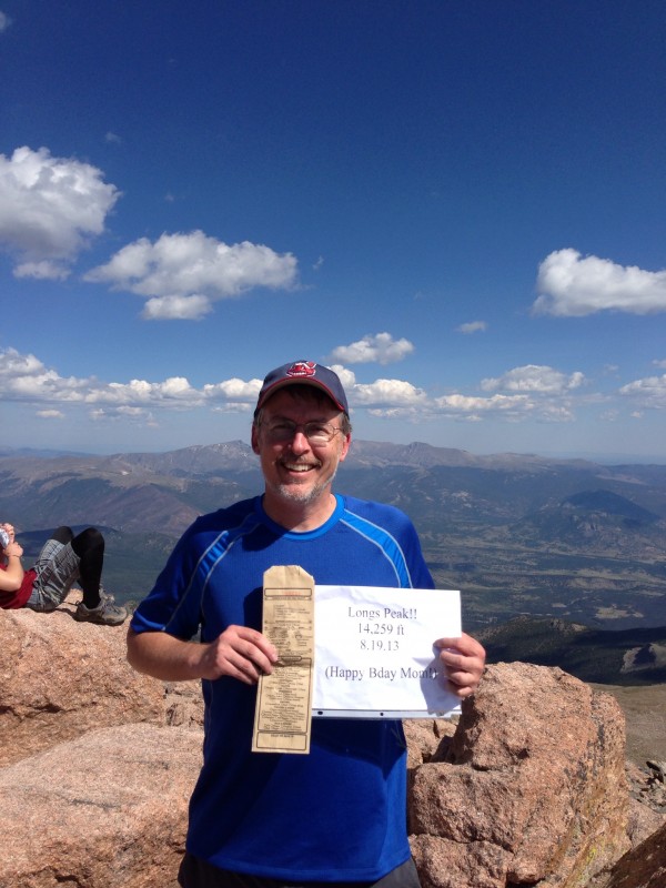 Evidently I made it. I'll do anything for "Mother's" birthday ... or a free sandwich. Locals know what the brown bag is all about and I generously shared. I also shared my sign. There must have been a lot of people whose mom also had a birthday this day. Hey, somebody photo-bombed my picture. I have to get me some of those leggings!  Yeah baby! Any questions?  Peeking north over the summit at Chasm Lake (foreground) and Peacock Lake (farther back).  There were probably 20 people on the summit including my new companions Jason and Ethan. They were kind enough to stay nearby on the way down even though I'm sure I slowed them down. Thanks alot guys - I really appreciated it! 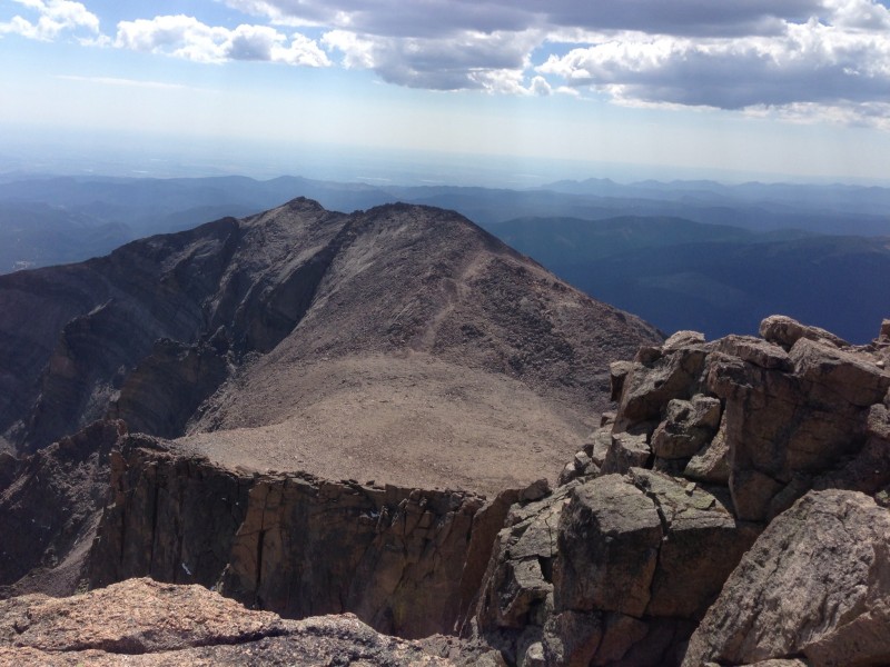 Mt Meeker and I presume "The Loft". I actually started researching alternate routes and the "Loft" approach sounds interesting. I think I'll be sticking with the Keyhole though.  The summit "football field". I wish I had had time to explore the entire periphery of the summit.  Heading back down from the top of the Home Stretch. There are two people near the middle in the shaded area. 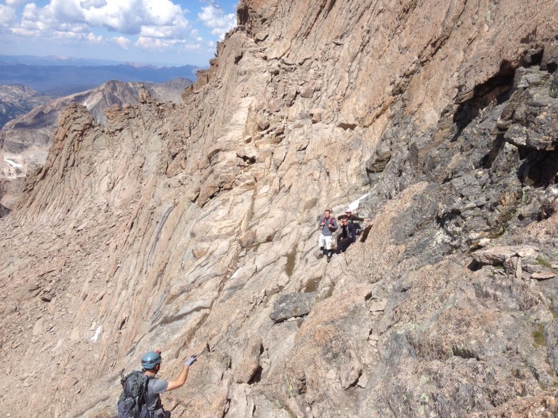 Looks like Jason suggesting a strategy to an attentive audience on the Narrows - or perhaps putting a "hex" on them. I had seen this shot dozens of times with the "roller coaster" (my name for it - top middle) on the Narrows and I'm glad I now have one of my own. This view always looked very intimidating ("so, you walk where?") but you just have to trust that there is a pathway along the roller coaster crack. And go carefully. If you blow the picture up, you can see two notches along the ridge as you come down the roller coaster hill. I think that the first one you get to is the passage to the Trough because I remember thinking it was the larger V-notch farther away and was pleasantly surprised to find that it was not. 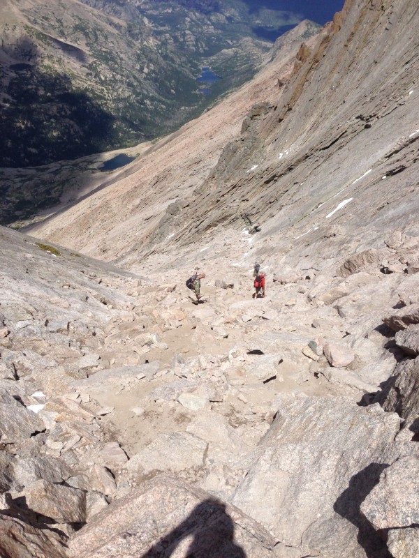 Looking down from top of the Trough. Again my apologies for not doing a photographic study of the "Chockstone". Lots of work still to do, but I was feeling considerable relief at this point. And I used trekking poles for this section. Not sure if anyone else did. My "cairn" of goodies (see text) greeted me at the bottom. 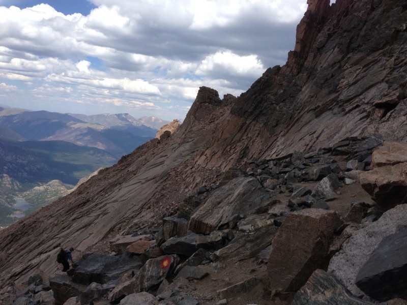 Finally back on the Ledges.  Getting closer to the Keyhole. Clouds moving in. View is to the northwest I think.  Kind of odd. I was both relieved and saddened to be leaving. This was one of the most exhilarating experiences I've ever had, and my sense of accomplishment is not something that I'll soon forget. I hope to be back ... Thumbnails for uploaded photos (click to open slideshow):  topo map")
 Chasm Lake")
 Longs early morning")
 warning sign")
 Phil and Boulderfield")
 The Keyhole Guardian")
 Phil on the Ledges")
 Ledges looking toward Trough")
 Ledges two bars in rock")
 Ledges looking down")
 Ledges looking back")
 The Narrows bottleneck")
 The Narrows looking toward Home Stretch")
 Home Stretch 1")
 Pagoda from Home Stretch")
 Home Stretch 2")
 Summit Happy Bday Mom")
 King of the Mountain")
 Chasm Lake from above")
 friends on the Summit")
 Meeker and Loft")
 Summit Moonscape")
 Back down the Home Stretch")
 Narrows towards Trough")
 Trough on way back looking down")
 Trough on way back looking up")
 Back on the Ledges")
 Ledges almost to Keyhole")
 So")
|
| Comments or Questions | |||||||||||||||
|---|---|---|---|---|---|---|---|---|---|---|---|---|---|---|---|
|
Caution: The information contained in this report may not be accurate and should not be the only resource used in preparation for your climb. Failure to have the necessary experience, physical conditioning, supplies or equipment can result in injury or death. 14ers.com and the author(s) of this report provide no warranties, either express or implied, that the information provided is accurate or reliable. By using the information provided, you agree to indemnify and hold harmless 14ers.com and the report author(s) with respect to any claims and demands against them, including any attorney fees and expenses. Please read the 14ers.com Safety and Disclaimer pages for more information.
Please respect private property: 14ers.com supports the rights of private landowners to determine how and by whom their land will be used. In Colorado, it is your responsibility to determine if land is private and to obtain the appropriate permission before entering the property.


