Download Agreement, Release, and Acknowledgement of Risk:
You (the person requesting this file download) fully understand mountain climbing ("Activity") involves risks and dangers of serious bodily injury, including permanent disability, paralysis, and death ("Risks") and you fully accept and assume all such risks and all responsibility for losses, costs, and damages you incur as a result of your participation in this Activity.
You acknowledge that information in the file you have chosen to download may not be accurate and may contain errors. You agree to assume all risks when using this information and agree to release and discharge 14ers.com, 14ers Inc. and the author(s) of such information (collectively, the "Released Parties").
You hereby discharge the Released Parties from all damages, actions, claims and liabilities of any nature, specifically including, but not limited to, damages, actions, claims and liabilities arising from or related to the negligence of the Released Parties. You further agree to indemnify, hold harmless and defend 14ers.com, 14ers Inc. and each of the other Released Parties from and against any loss, damage, liability and expense, including costs and attorney fees, incurred by 14ers.com, 14ers Inc. or any of the other Released Parties as a result of you using information provided on the 14ers.com or 14ers Inc. websites.
You have read this agreement, fully understand its terms and intend it to be a complete and unconditional release of all liability to the greatest extent allowed by law and agree that if any portion of this agreement is held to be invalid the balance, notwithstanding, shall continue in full force and effect.
By clicking "OK" you agree to these terms. If you DO NOT agree, click "Cancel"...
If you want to get technical, this was our last 14er(if you use the 53 list) however its #57 with North Maroon remaining.
I would sum this trip up as very fun and enjoyable, not nearly as difficult as expected(or other people hype up). Parking Lot View
We hiked in the afternoon before. We opted to take the ditch trail, not sure many people use the lower trail any longer. I had been in to camp years ago at the lake and the approach was just as enjoyable this time. I feel this is one of the most scenic hikes, even if your only objective is the lake. We passed 13 people who were hiking back out, all were day hikers. So don't get discouraged when you pull up to the parking lot and its full. There was plenty of camp spots available. There is a gate to go through between 4-5 miles that i didn't recall on the prior hike. We chatted with a guy on top about the gate, which really threw him for a loop since its not talked about. So expect it. It marks the end of cattle grazing. Stream Crossing
We settled on Camp #5 for the night. There is an advantage to the upper campsites - they are directly across from the turn off to the Daly saddle. There is a nice 4-way junction there. We arrived at the camp sites around 4:00 and enjoyed dinner at the lake. It rained for approx 5 hours starting at 7:00 that night.
The alarm went off at 3:30 and we hit the trail at 3:50am. We had hopes of reaching K2 by sunrise. The daly saddle approach is very straight forward and easy.
Im not going to go into detail on every step of the climb, however here are a few notes that I think are important:
1. The trail from the saddle is very easy to follow....for approx 200 yards.
2. The trail abruptly ends and kind of cliffs out at the 200 yard mark. Back track about 10-20 feet and you will see the trail make several sharp switchbacks down grassy ledges. This was very difficulty to see in the dark. The trail drops about 50-100 vertical feet, turn right and start the traverse into the basin.
3. We were able to follow the route described on this site exactly. Just aim for the jagged ridge line in front of you(dependent on moon light obviously), staying to the left of the slope/ridge on your right side. If you look hard, you can follow cairns the whole way to K2.
4. You must traverse a long way under the cliffs. It feels like you are getting to close too the ridge line in front of you. From here turn right and head toward K2. The area were the trail turns right is full of light tan colored boulders that are fun to pick your way through.
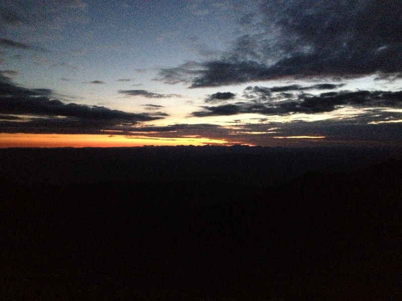
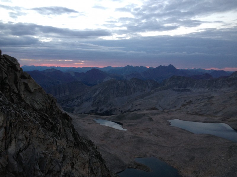
We made K2 around 6:00 and watched the sunrise - awesome! Sunrise Bells and Pyramid
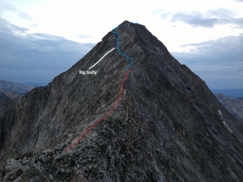
I opted to summit K2. Take the ridge line directly to the summit, its not that bad.
If you decide to skip K2, follow the ridge line very high before you traverse to the right. It makes it much easier!
The traverse around K2 is not near as dramatic as expected, however the "gash" on the other side is fun to look down.
I would separate the remaining route into two sections: The ridge proper (knife edge).
The face traverse. Edge and Face routes
The ridge:
There is some exposure here however the rock is very stable. There were a few small sections on the ridge to pass over that were harder than the knife we thought. They are short sections though. After the knife edge, there are several sections of the ridge that are easier to bypass on the right(north) side. You can drop down about 5 feet from the crest and traverse. Knife Edge
I had a little fun crossing the ridge on the way back - no hands tightrope walk, see video:
Pretty proud of my dad, he walked the whole thing too, only using his hands twice!
The face:
After the ridge ends, drop down in a small notch before heading up. Go up the face approx 50 feet, then start the traverse. There are some good trail segments here and cairns. It was a lot easier to route find than expected. The first part of the the traverse has some really long drop offs. Take your time, the rock here is more loose than the ridge, but not bad.
Continue to traverse, without gaining much elevation until you reach the big gully. Cross to the other side of the gully and begin to head up steeper rock. The rock here is really stable if you stay more left. Climb up for about 100 feet, the slope eases, and continue the traverse to the south ridge line. Gain the ridge and pick your way to the top. Face Traverse
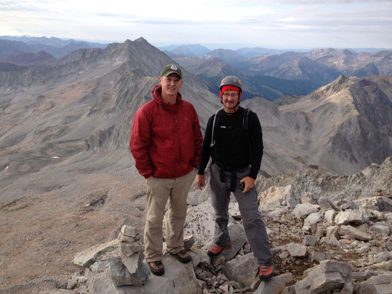
The summit was great, we had nice cloud cover all morning. It felt pretty good to summit the last "official" 14er. There is still one more to go though, so no celebration yet.
My dad was pretty worried about this climb prior, but he had a blast once we got on the mountain. Summit
The decent is a lot easier on the way down, you've built all that confidence on the way up.
Thumbnails for uploaded photos (click to open slideshow):
Enjoyed your TR about one of my favorite Fourteeners.
Excellent photography and great route highlighting! Glad to see that The Elder RescueMonkey went for it with you. On that mountain, The Elder was wise in deed to show some trepidation! Although the video makes walking-the-line seem relatively easy, I'll have to side with The Elder on the use of other appendages for stability!
Hey, unless I've miss-read something in your TR, I have always found North Maroon to be on the list of enumerated Fourteeners. One look across that challenging traverse between the Bells shows why. Anyway, North Maroon is a very different beast than Maroon, so be sure to do it, required or not. It too is a classic Elk Range climb -- and worth every bit of the logistical planning and hassle to get to.
We'll be looking for your final report on number 54,56, 58, or whatever. After all, as I am sure that you (and The Elder) well know by now, it's not about the counting or checklists. It's all about the adventure!
Maybe I should clarify on the count. IF you stick hard with the 300' foot drop rule-of-thumb, we are done with the 53 peaks. That's what I meant by being ”officially” done. We are however adding North Maroon, Cameron, Conundrum, North Eolus and El Diente - of which only North Maroon remains for us.
I found an interesting break down on ”the list” of peaks at www.14erfanclub.com. This site shows what different organizations count and don't count.
Anyhow, it is about the adventure and not the list. Maybe I'll see you out there on the 13ers or 12ers.
Great trip report. That is a great picture of the remaining route after the knife edge. Question--how was getting around K2? Did you guys downclimb from the summit of K2 or go around on the north side like the other route reports indicate? I've heard that's the hardest part.
Going next week! Hope there isn't any snow in the interim.
Caution: The information contained in this report may not be accurate and should not be the only resource used in preparation for your climb. Failure to have the necessary experience, physical conditioning, supplies or equipment can result in injury or death. 14ers.com and the author(s) of this report provide no warranties, either express or implied, that the information provided is accurate or reliable. By using the information provided, you agree to indemnify and hold harmless 14ers.com and the report author(s) with respect to any claims and demands against them, including any attorney fees and expenses. Please read the 14ers.com Safety and Disclaimer pages for more information.
Please respect private property: 14ers.com supports the rights of private landowners to determine how and by whom their land will be used. In Colorado, it is your responsibility to determine if land is private and to obtain the appropriate permission before entering the property.
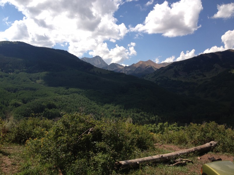


 Parking Lot View")
 Stream Crossing")
 Sunrise")
 Edge and Face routes")
 Knife Edge")
 Face Traverse")
 Summit")
 Bells and Pyramid")


