Download Agreement, Release, and Acknowledgement of Risk:
You (the person requesting this file download) fully understand mountain climbing ("Activity") involves risks and dangers of serious bodily injury, including permanent disability, paralysis, and death ("Risks") and you fully accept and assume all such risks and all responsibility for losses, costs, and damages you incur as a result of your participation in this Activity.
You acknowledge that information in the file you have chosen to download may not be accurate and may contain errors. You agree to assume all risks when using this information and agree to release and discharge 14ers.com, 14ers Inc. and the author(s) of such information (collectively, the "Released Parties").
You hereby discharge the Released Parties from all damages, actions, claims and liabilities of any nature, specifically including, but not limited to, damages, actions, claims and liabilities arising from or related to the negligence of the Released Parties. You further agree to indemnify, hold harmless and defend 14ers.com, 14ers Inc. and each of the other Released Parties from and against any loss, damage, liability and expense, including costs and attorney fees, incurred by 14ers.com, 14ers Inc. or any of the other Released Parties as a result of you using information provided on the 14ers.com or 14ers Inc. websites.
You have read this agreement, fully understand its terms and intend it to be a complete and unconditional release of all liability to the greatest extent allowed by law and agree that if any portion of this agreement is held to be invalid the balance, notwithstanding, shall continue in full force and effect.
By clicking "OK" you agree to these terms. If you DO NOT agree, click "Cancel"...
I had to go to Utah where my girlfriend had been staying for the Summer to drive back with her to Tempe. So, I said let's do Kings Peak before we roll out. Getting to the trail head is pretty straighforward (Henrys Fork TH). The campground right before the trailhead had the cleanest bathrooms I'd ever been in. Literally no discernible difference in air quality between in and out. Huh. Anyhow, we pulled up to the campground around 7 and set up shop in the back of her 4Runner. We were the only people there. We did see a few cars up at the actual trailhead. We caught a rainbow which led to a discussion on beliefs in omens...
The approach to Gunsight Pass is long and uneventful. Very long. As Wikipedia says, "Kings Peak is generally regarded as the hardest state highpoint which can be climbed without specialist rock climbing skills and/or guiding. The easiest route requires a 32 plus mile hike, much of it over boulder fields." I'd edit out that part about boulder fields... On the long approach:
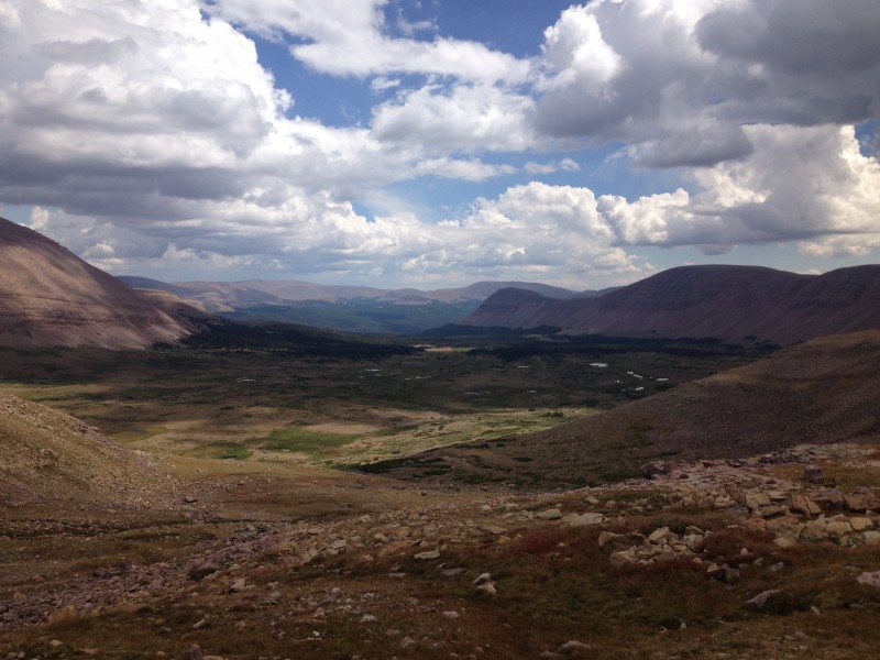
We got up to Gunsight Pass with no problems. As we headed over the top to dip back down into Painters Basin, there were a couple guys on horses with dogs herding about a hundred sheep up the pass. We got past them right before it would have been us vs. the sheep. Here's a look of Painters Basin:
We skirted around on a fairly well marked side trail that prevents having to dip all the way into the basin. I figure here we saved a mile or two/three total. Then we headed back up to the saddle for Kings Peak. It is all rock with no trail for a mile up to the top. Fun, but time consuming. Here's a shot at the saddle:
The hike up the ridge to the top is fun, just keep left or stay on top of the ridge, either/or. We did a bit of both. Almost to the top, you'll see the rocks have grown bigger and just cut up and you're there. There is an old artillery case that houses the register. No summit marker. I had to get my lady doing her gratuitous victory pose up top:
We got back down to the saddle. Here is a view looking over at the gully that some say you can ascend/descend. I'd read it was loose and didn't feel like giving it a look or go. The trail we took drops down to the right in this photo and skirts the peak back around to gunsight pass.
Just after clearing Gunsight on our descent, we encountered rain and hail. It last only a few minutes, but soaked us on an exposed portion of the trail before you get back down to the trees. The hike out was long. Very long. We jogged a bit trying to keep our time good. Here's a view of the creek the parallels the trail for the first few miles:
We finally made it back to the trailhead in 11 hours. Now, before we had started this hike, we had looked for good info on the trail length. We saw anywhere from 23 miles up to 32 miles. We guesstimated it was probably close to 29 miles. We had started the day assuming 23 miles, but as we ran and realized that we still had a long way to go, we realized there was no way we could be going that slow.
So, this hike is doable in a day if you're looking to do so. We had started at 5:30am as we had slipped our 3am time (oops). Rain did come, but thunder/lightning were not factors. After a quick stop in Zion, we're now safely back in AZ ready to see where our next adventure takes us (Panama!). Here's the happy couple back at the trailhead after completing Kings in a day.
Thumbnails for uploaded photos (click to open slideshow):
Hi guys. Liked your post. We did the same at beginning of July this year. It was long for sure. Excellent views, beautiful scenery. Loved it! Ditto on the hail and rain for us!
Good report on a nice state highpoint! I did this two years ago with a backpack in and camp just before Gunsight Pass. The scramble from the saddle to the summit was one of the most fun scrambles I have done! I descended via the gully; it was steep and loose but mild compared to some of the 14ers.
Caution: The information contained in this report may not be accurate and should not be the only resource used in preparation for your climb. Failure to have the necessary experience, physical conditioning, supplies or equipment can result in injury or death. 14ers.com and the author(s) of this report provide no warranties, either express or implied, that the information provided is accurate or reliable. By using the information provided, you agree to indemnify and hold harmless 14ers.com and the report author(s) with respect to any claims and demands against them, including any attorney fees and expenses. Please read the 14ers.com Safety and Disclaimer pages for more information.
Please respect private property: 14ers.com supports the rights of private landowners to determine how and by whom their land will be used. In Colorado, it is your responsibility to determine if land is private and to obtain the appropriate permission before entering the property.


")
")
")
")
")
")
")
")