Download Agreement, Release, and Acknowledgement of Risk:
You (the person requesting this file download) fully understand mountain climbing ("Activity") involves risks and dangers of serious bodily injury, including permanent disability, paralysis, and death ("Risks") and you fully accept and assume all such risks and all responsibility for losses, costs, and damages you incur as a result of your participation in this Activity.
You acknowledge that information in the file you have chosen to download may not be accurate and may contain errors. You agree to assume all risks when using this information and agree to release and discharge 14ers.com, 14ers Inc. and the author(s) of such information (collectively, the "Released Parties").
You hereby discharge the Released Parties from all damages, actions, claims and liabilities of any nature, specifically including, but not limited to, damages, actions, claims and liabilities arising from or related to the negligence of the Released Parties. You further agree to indemnify, hold harmless and defend 14ers.com, 14ers Inc. and each of the other Released Parties from and against any loss, damage, liability and expense, including costs and attorney fees, incurred by 14ers.com, 14ers Inc. or any of the other Released Parties as a result of you using information provided on the 14ers.com or 14ers Inc. websites.
You have read this agreement, fully understand its terms and intend it to be a complete and unconditional release of all liability to the greatest extent allowed by law and agree that if any portion of this agreement is held to be invalid the balance, notwithstanding, shall continue in full force and effect.
By clicking "OK" you agree to these terms. If you DO NOT agree, click "Cancel"...
| The Great Mount Sneffels: Southwest Ridge Classic |
Mount Sneffels is an awesome mountain. I was convinced of this as I saw it for the first time from Montrose on Sunday afternoon a few weeks ago. Our group of 7 climbers were traveling south from Denver to climb some San Juan 14ers, and this was first on the list. We drove to Ouray and up the Camp Bird road a few miles until the Angel Creek campground, which worked out really well for us. The next morning, we drove up to the lower TH and started hiking up the 4WD road, feasting our eyes on the rugged and beautiful surrounding landscape of Yankee Boy Basin...
A colorful peak named Stony Mountain towers to the left:


Absolutely breathtaking views reward us as we climb up the basin:

Our objective comes into view as we approach the signs at the upper trailhead:


We had a brief discussion about which route to take, but everybody agreed that it would be the Southwest Ridge - longer, but hopefully much more rewarding and fun! So, off we went. The route climbs up to Blue Lakes Pass and then winds around to the left side of the ridge for the most part to get around the spires. As it gets closer to the summit, the spires give way to fun, knobby rock that gets more and more solid until the top!
At the junction that splits the standard and Southwest Ridge routes:

Gilpin Peak, hiding behind a cloud:

Mt. Sneffels in full view - standard route up the col on the right, our route on the left:

Can't ever get enough of this view - looking down Yankee Boy Basin from near Blue Lakes Pass:


One more time - from the top of the pass:


From the Blue Lakes Pass, the fun really begins. We found that the short gullies that the route climbs up as it traverses left below the crest are relatively solid.
The Southwest Ridge:

As we climb, we find that hiking up to the ridge crest between the spires provides a great view of Yankee Boy Basin:


The view down toward Blue Lakes Basin (yes, they really are blue!):


At one point, the left side of the ridge becomes much more steep and rugged...

...so, we traverse to the right side, where we find cairns:

The cairns lead us over the rock rib shown above, and we climb up the gully on the opposite side, encountering more difficult climbing as the route climbs back to the ridge crest.

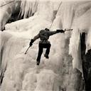
Having some fun:

The route climbs back over the crest and around the left side one more time, as the "Kissing Camels" formation comes into view:

Finally, the route gains the crest and stays there for the remainder of the climb.
Gaining the ridge crest one last time:

From here, all that remains is fun scrambling! At first, the rock is talus...

...but just above, it turns knobby and solid, providing some excellent scrambling!

The ridge soon narrows and increases difficulty, but the summit is just beyond!

Final stretch:


And then the summit!
Blue Lakes Basin:


Although it was cold, we had to take some time to enjoy our accomplishment. I felt, more than on most 14ers, much higher up from the surrounding terrain, even though there were plenty of high peaks around. The fog rolled in steadily, and the temps didn't rise at all, so before long we all decided to get moving down.
Back down the standard route:

Despite the loose rock, it doesn't take long to get off this mountain! We all had some fun sliding down the scree:

And finally, back down the colorful basin:

And that's it! Thanks for reading.
|
Caution: The information contained in this report may not be accurate and should not be the only resource used in preparation for your climb. Failure to have the necessary experience, physical conditioning, supplies or equipment can result in injury or death. 14ers.com and the author(s) of this report provide no warranties, either express or implied, that the information provided is accurate or reliable. By using the information provided, you agree to indemnify and hold harmless 14ers.com and the report author(s) with respect to any claims and demands against them, including any attorney fees and expenses. Please read the 14ers.com Safety and Disclaimer pages for more information.
Please respect private property: 14ers.com supports the rights of private landowners to determine how and by whom their land will be used. In Colorado, it is your responsibility to determine if land is private and to obtain the appropriate permission before entering the property.