Download Agreement, Release, and Acknowledgement of Risk:
You (the person requesting this file download) fully understand mountain climbing ("Activity") involves risks and dangers of serious bodily injury, including permanent disability, paralysis, and death ("Risks") and you fully accept and assume all such risks and all responsibility for losses, costs, and damages you incur as a result of your participation in this Activity.
You acknowledge that information in the file you have chosen to download may not be accurate and may contain errors. You agree to assume all risks when using this information and agree to release and discharge 14ers.com, 14ers Inc. and the author(s) of such information (collectively, the "Released Parties").
You hereby discharge the Released Parties from all damages, actions, claims and liabilities of any nature, specifically including, but not limited to, damages, actions, claims and liabilities arising from or related to the negligence of the Released Parties. You further agree to indemnify, hold harmless and defend 14ers.com, 14ers Inc. and each of the other Released Parties from and against any loss, damage, liability and expense, including costs and attorney fees, incurred by 14ers.com, 14ers Inc. or any of the other Released Parties as a result of you using information provided on the 14ers.com or 14ers Inc. websites.
You have read this agreement, fully understand its terms and intend it to be a complete and unconditional release of all liability to the greatest extent allowed by law and agree that if any portion of this agreement is held to be invalid the balance, notwithstanding, shall continue in full force and effect.
By clicking "OK" you agree to these terms. If you DO NOT agree, click "Cancel"...
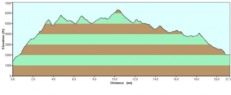
One day, solo Presidential Range Traverse, White Mountains, New Hampshire
~20 miles, 10,000' elevation gain/loss
Mt. Madison (5363'), Mt. Adams (5798'), Mt. John Quincy Adams (5410'), Mt. Jefferson (5715'), Mt. Clay (5533'), Mt. Washington (6288'), Mt. Monroe (5385'), Mt. Franklin (5003'), Mt. Eisenhower (4761'), Mt. Pierce (4291')
I've been on 14ers.com for about two years without posting a trip report. I wanted to save my first trip report for something big. Although this is not a Colorado 14er, I hope this fits the bill. This has been a great summer for me so far getting out almost every weekend to climb 13ers and 14ers in Colorado with new, great partners. I was planning to go home to New Jersey for two weeks and thought it would be a shame to end my climbing streak.
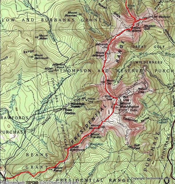
This past winter my friend Tom and I took a trip up to New Hampshire to attempt a Presidential Range Traverse. A Presidential Traverse usually begins at the north end of the Presidential Range in the White Mountains at Appalachia Trailhead and heads south over ten mountains to the Crawford Notch Highland Center about 20 miles away. Because of whiteout conditions and extremely high winds, Tom and I bailed a little less than halfway on Mt. Clay, just before the famous Mt. Washington. He made a video of our trip here: http://www.youtube.com/watch?v=GFON_10fJgw. Winter in the Whites puts Colorado weather to shame with a normal high of about zero degrees during the day and well into the negatives at night with high winds reaching up to 100 mph. It was so cold that my trekking poles actually froze in the extended position and snapped in half... I told myself that it would be a long time before I returned to the White Mountains.
Eight months later, I was driving back up to Appalachia Trailhead. Because of the exceptionally nice weather, I decided to run the whole traverse in one day. I knew 20 miles and 10,000' of elevation gain would be tough, but I had been preparing with long runs along the Boulder skyline and lots of 14er ascents. Most people usually use a car shuttle to get back from Crawford Notch to Appalachia, but because I was alone, I decided to use the AMC shuttle. I had to make it to Crawford Notch by 4pm on Wednesday to get a ride back to my car at Appalachia.
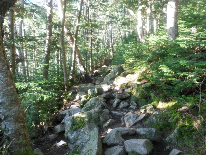
By 9pm on Tuesday night, I was eating pasta in the Appalachia parking lot and getting my stuff together for an early start the next day. I wanted to leave by 4:30am but the inside of my sleeping bag was just too comfortable. Several snooze buttons and an hour later, I was hiking and running up the Valley Way trail to Madison Springs Hut. I passed one group only a mile into the climb and didn't see anyone else until the hut. The trail was very different from Colorado trails; it was steep without switchbacks and extremely rocky.
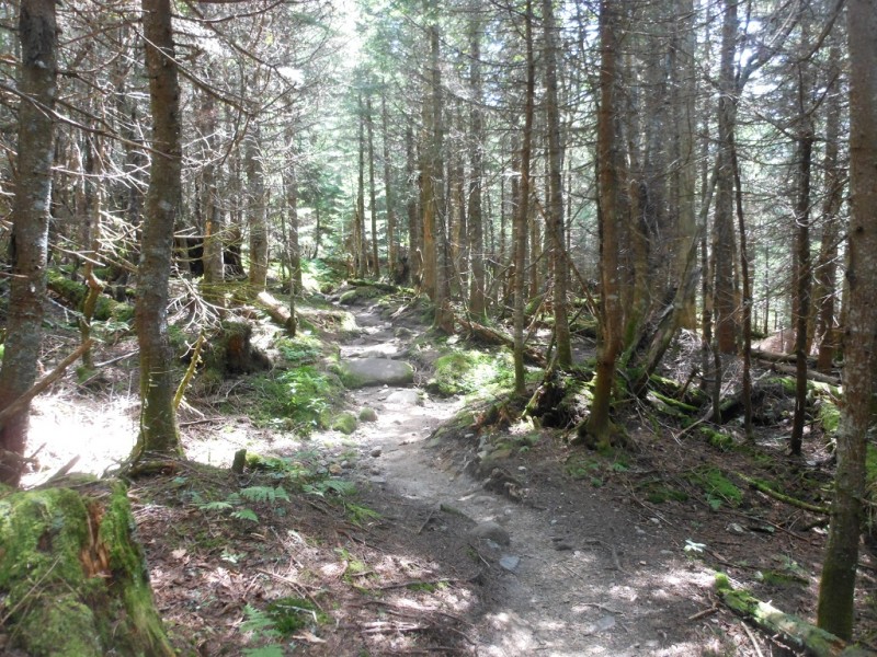
Smooth, runnable trail on the Vally Way Trail...
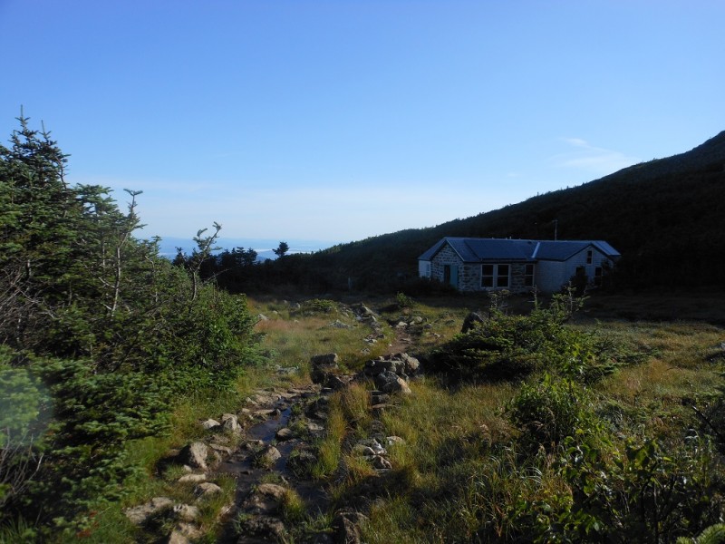
This 4000' climb in only a few miles was supposed to be hardest part, but I was feeling surprisingly great. My lungs loved the thick, oxygen rich air of the White Mountains. I made it above treeline to the col between Mt. Madison and Mt. Adams where Madison Springs Hut lies.
Madison Springs Hut in front of Mt. Madison
I could see several backpackers who stayed the night in the hut peering out the windows with astonished looks at the crazy runner zooming past. I didn't waste any time and ran/boulder hopped my way to the top of Mt. Madison.
View north from near the summit of Mt. Madison
After only a few minutes on top, I was heading back down. I stopped in the hut to use the bathroom (oh the luxuries of running in the Northeast's most popular hiking area), and soon I was off to Mt. Adams.
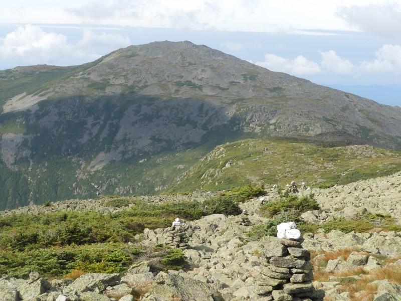
The climb to Mt. Adams was more of a hike because it was so rocky. I had to keep my eyes on my feet the entire time. I could see how you could easily twist your ankle if you lost focus for just a second. I didn't see anyone on the way to the summit of Adams, which made for some nice solitude in such a busy place. I knew I still had a long day ahead of me, so after only a few minutes on top, I continued on to Mt. John Quincy Adams, Mt. Jefferson, and then Mt. Clay. The trail was more of the same slow boulder hopping. I was excited to be getting closer to Mt. Washington because I would be halfway and the trail would be much smoother and runnable on the southern side.
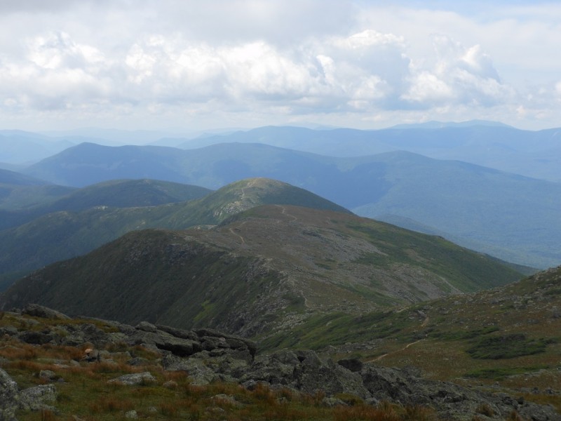
Mt. Washington (left) and Mt. Adams (right)
Just a few cairns leading to Mt. Jefferson
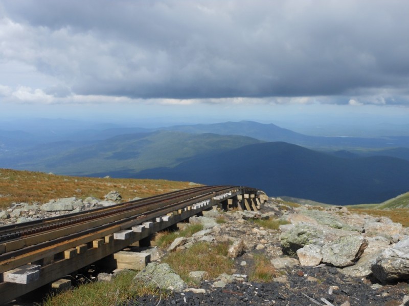
After Mt. Clay, which is really just a sub-mountain of Mt. Washington, I was running next to the cog railway that takes tourists up to the summit of Mt. Washington. I was running into a cloud as I neared the summit, but the weather was fantastic. It was mostly sunny and just breezy enough to cool me off.
The cog railway
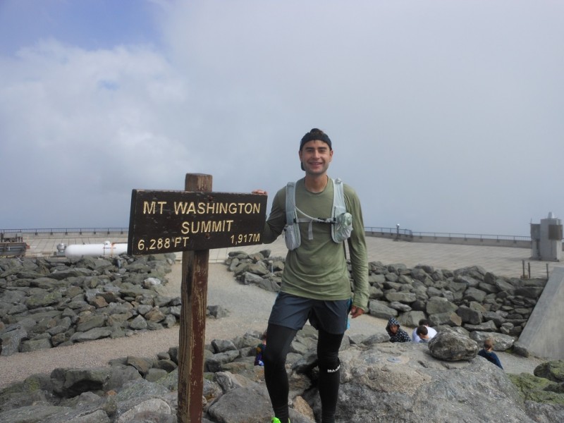
Highest point in the Northeast!
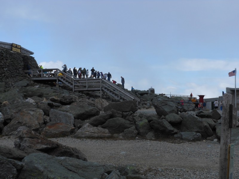
All the tourists that "climbed" Mt. Washington
On top of Mt. Washington, I refilled my water quickly and weaved through the flip flop and sweatshirt clad tourists to find the right trail to the southern Presidentials. I haven't climbed Pikes Peak or Mt. Evans but I imagine it would be a similar sight. A couple people came up to me asking how far I had hiked, and they couldn't believe it when I said about ten miles and ten more still to go. After searching for the Crawford Path for a few minutes, I was heading down to Lake of the Clouds.
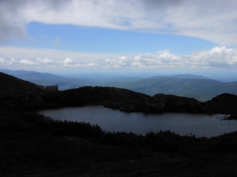
Lake of the Clouds
The trail was still rocky, but it was slightly more runnable and reminded me of a long line of stepping stones. I was moving much faster now and soon, I was running past Lake of the Clouds and the hut that overlooks it to Mt. Monroe.
Mt. Monroe ahead
The trail was still rocky but easy to run. This, with the combination of fewer crowds after Lake of the Clouds, made the next ten miles my favorite part of the trip. Almost all trip reports I had read about the traverse said that the southern Presidentials were boring with bad views. I must be in the minority but I found this part to be tons of fun!
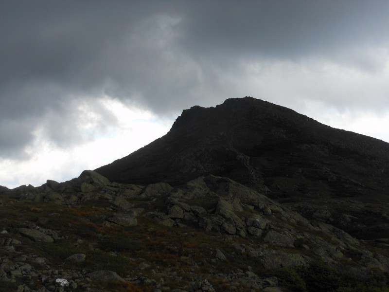
The southern Presidentials. Mt. Franklin, Mt. Eisenhower, and Mt. Pierce ahead.
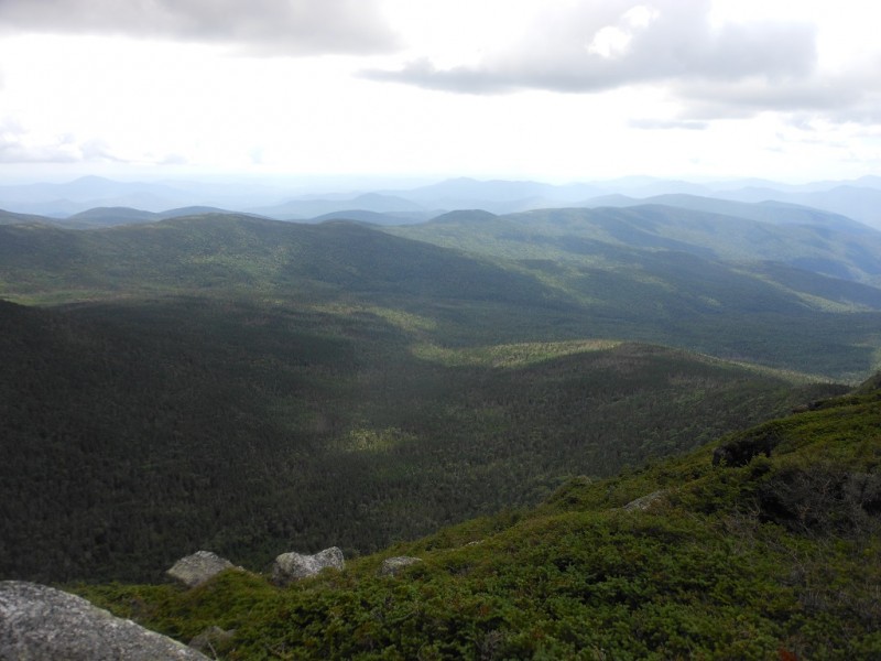
Great Gulf Wilderness
I made quick time over Mt. Monroe, Mt. Franklin, Mt. Eisenhower, and Mt. Pierce. Some people choose to continue on to Mt. Jackson and Mt. Webster but for the sake of time, I had to descend to the Crawford Notch Highland Center on the Crawford Path. Jackson and Webster are not named for U.S. Presidents so they do not officially count as part of the traverse. I was feeling great at this point and wish I could have continued on.
The trail back to the Highland Center started off nice and smooth but became rocky, and I was forced to hike back to the bottom.
Crawford Path
After nine hours and ten minutes, I was finally eating a delicious Italian sub and drinking a fine local Tuckerman's Pale Ale at the Highland Center. The fastest known time for the traverse is just under five hours. Although I still had plenty left in the tank, I don't see how one could travel much faster over such rocky terrain. For breakfast, I had a Naked Green Machine smoothie, and during the run, I ate about 1500 calories of Stinger gels, Stinger waffles, Clif Shot blocks, Skratch electrolyte mix, and salt pills. I was never hungry and never thirsty, which was a huge accomplishment for me for a nine hour run/hike. I forgot my running watch that tracks elevation, but I found this elevation profile and route online.
Upcoming Colorado plans: I am a poor, car-less college student living in Boulder who really appreciates rides to the mountains. Sometime this fall, I want to attempt the Sawatch Grand Slam (http://www.14ers.com/php14ers/tripreport.php?trip=11966) and Wetterhorn and Uncompahgre in a day. For the winter, I want to work on the Sawatch Range with a lot of trailhead camping. If any of that sounds interesting, please PM me!
Thumbnails for uploaded photos (click to open slideshow):
Hey Matt! Great post and great climb! I'm from Massachusetts and have done all you mentioned except Jefferson. Difference is I didn't do em all at once!
We are lucky to have the White Mts here as they are beautiful and fun, and be good climbs. Again, excellent achievement for you!
Hey Matt, It's Bryan from our Decalibron venture this past winter. Awesome job running the Presidential Traverse. Glad to see you took some time to snap a few photos :) G'luck with the rest of your hiking!!
Love seeing this side of the country! 8/10/2013 12:28am
Not only do I envy you guys that just run peaks of any shape or form but I love looking at this side of the country through eyes like yours! Way to go on your adventure and I look forward to more of your reports!
That is a fun ridge! Brought back some great memories when I hit them all several years ago (but in 2 separate days - Ha! :D )
And yeah, those trails are steep and rocky! I also remember those cairns with the white quartz rocks on top. They almost seemed like street light beacons, especially when you were engulfed with fog and mists. Thanks for post! :D
you are FAST! btw meeker is still waiting for us to finish :-b doubt i can keep up with you though. also you are welcome to borrow my car on most weekdays.
Love that area and hope to knock off the traverse next time I make it that way. Next time you're up there, try the ridge from Lafayette to Little Haystack off of Franconia Notch. Not nearly as long, but still a good one!
This is neat. I wonder if it's possible for fast hikers (non-runner though) to complete this in a day. I guess it just depends on the weather. Looks like a nice day in the mountains.
Caution: The information contained in this report may not be accurate and should not be the only resource used in preparation for your climb. Failure to have the necessary experience, physical conditioning, supplies or equipment can result in injury or death. 14ers.com and the author(s) of this report provide no warranties, either express or implied, that the information provided is accurate or reliable. By using the information provided, you agree to indemnify and hold harmless 14ers.com and the report author(s) with respect to any claims and demands against them, including any attorney fees and expenses. Please read the 14ers.com Safety and Disclaimer pages for more information.
Please respect private property: 14ers.com supports the rights of private landowners to determine how and by whom their land will be used. In Colorado, it is your responsibility to determine if land is private and to obtain the appropriate permission before entering the property.