Download Agreement, Release, and Acknowledgement of Risk:
You (the person requesting this file download) fully understand mountain climbing ("Activity") involves risks and dangers of serious bodily injury, including permanent disability, paralysis, and death ("Risks") and you fully accept and assume all such risks and all responsibility for losses, costs, and damages you incur as a result of your participation in this Activity.
You acknowledge that information in the file you have chosen to download may not be accurate and may contain errors. You agree to assume all risks when using this information and agree to release and discharge 14ers.com, 14ers Inc. and the author(s) of such information (collectively, the "Released Parties").
You hereby discharge the Released Parties from all damages, actions, claims and liabilities of any nature, specifically including, but not limited to, damages, actions, claims and liabilities arising from or related to the negligence of the Released Parties. You further agree to indemnify, hold harmless and defend 14ers.com, 14ers Inc. and each of the other Released Parties from and against any loss, damage, liability and expense, including costs and attorney fees, incurred by 14ers.com, 14ers Inc. or any of the other Released Parties as a result of you using information provided on the 14ers.com or 14ers Inc. websites.
You have read this agreement, fully understand its terms and intend it to be a complete and unconditional release of all liability to the greatest extent allowed by law and agree that if any portion of this agreement is held to be invalid the balance, notwithstanding, shall continue in full force and effect.
By clicking "OK" you agree to these terms. If you DO NOT agree, click "Cancel"...
NOTE 3: This is NOT the Roach "South Ridge/Discovery Ridge" route 29R7. The only TR for that route I have found is this one.
If you find yourself in the Chicago Basin, your scrambling skills are up to par, and you want to do the most enjoyable route on a somewhat popular peak, then the southeast ridge of Eolus should be on your short list. Steady class 3 interspersed with a few short class 4 moves on surprisingly solid rock awaits. (I did one low-5th downclimb out of a notch, but I'm pretty sure an easier option existed)
I happened upon it simply out of curiosity. I had a few hours to kill and had read Roach's description of "Discovery Ridge" many times over the years. Heading up from my fairly low campsite at 10,900', I saw a nice ridge line and decided to give it a go, turning left off the trail at approximately 11,000.
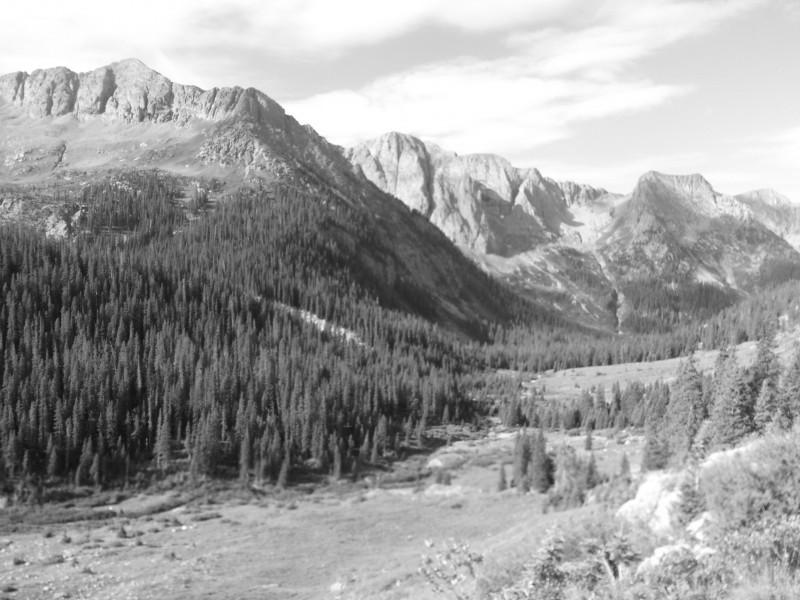
The view of Mt. Eolus from the Needle Creek trail at 11,000
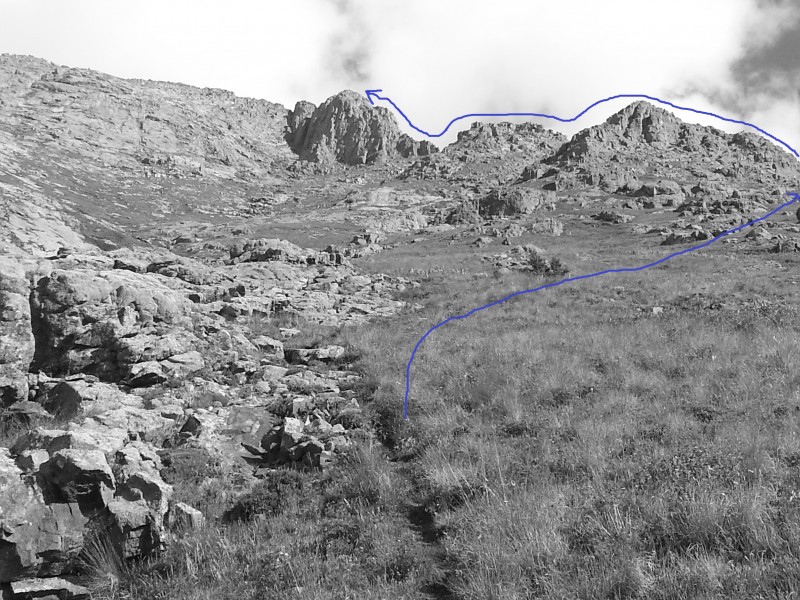
As far as I can tell, Roach's South Ridge route is approximately the red line. I took the ridgeline to its right, in blu
I stayed either in or just to the right of a somewhat prominent gulley until approximately 11,900' and then veered right to meet the ridge at the bottom. From this vantage, I couldn't help but see most of the line in front of me...it looked very nice!
Rocky gulley on the left
The valley floor dropping below
Veer right to tackle the ridge
Needle Ridge, Sunlight Peak, Sunlight Spire, Windom, even Jupiter made their way into this picture
What I soon began to love about this route was its simplicity. Gain the ridge. Go up. When in doubt, go around something. The rock was in great shape.
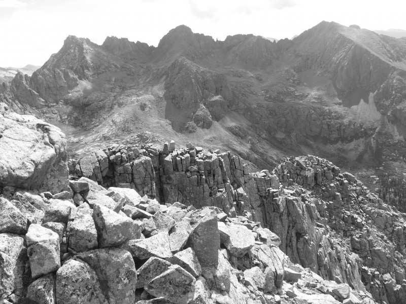
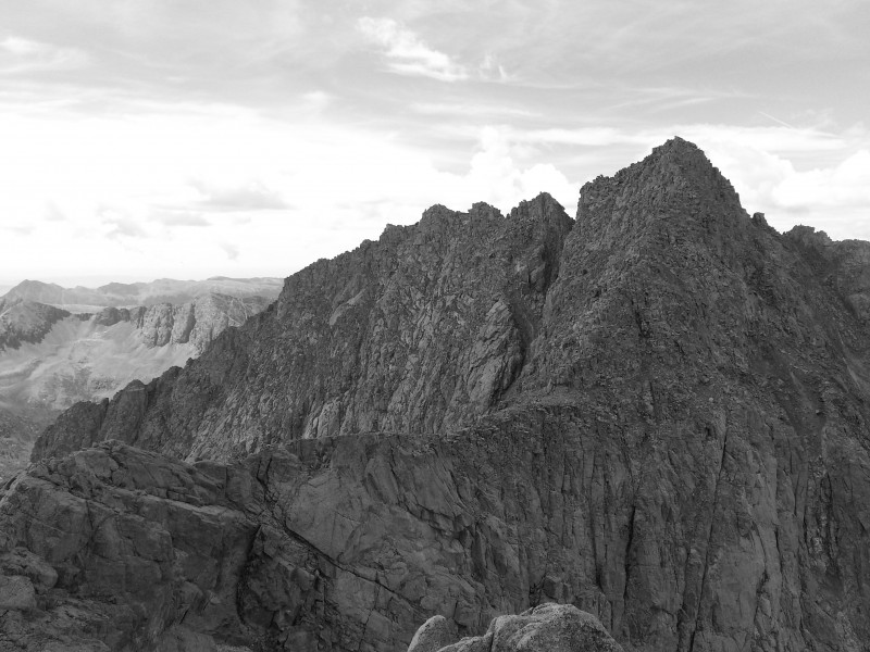
A look at the SE ridge from 13,000-ish'
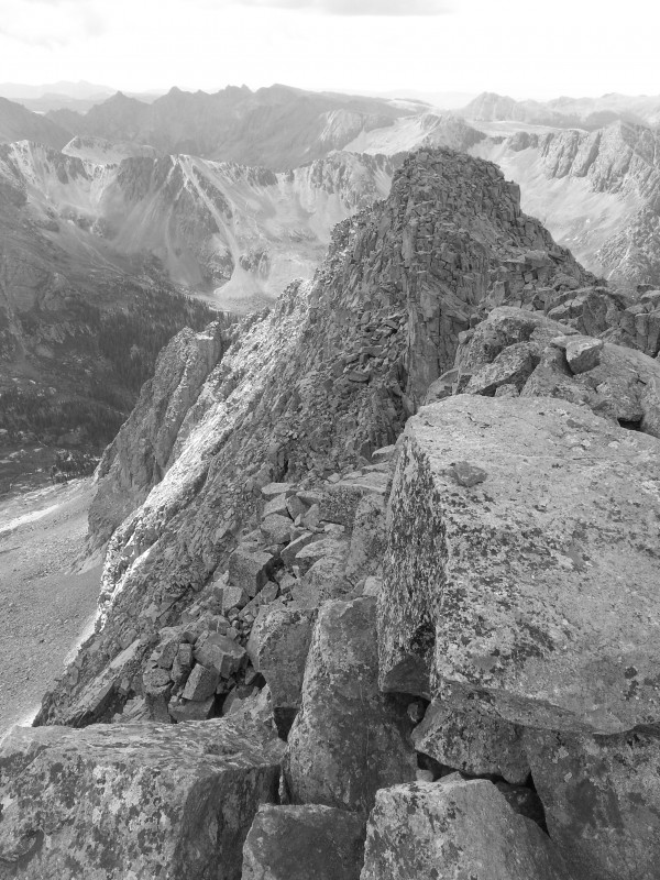
South Ridge(red) and Southeast Ridge(blue)
The trickiest climbing probably involved getting across a couple of notches, where I got baited into staying too high on the ridge and had to give back some of my elevation.
looking back at a portion of the ridge
Sidenote: since there's a South Wilson, a South Little Bear, even a South South Massive, I think there should also be a South (or Southeast) Eolus. The south peak is over 14,000', it took about 5-10 minutes to make it to the real summit, and I had to drop to 13,980' or so to get there.
view of Eolus from "South Eolus"
view of "South Eolus" from Eolus
I hopped over to North Eolus while I was at it and scooted back down to my campsite. It was a quick climb, only 2h30 RT with some jogging down from North Eolus.
Grenadier's morning face. Still pretty, ain't she?
Clear view of the upper SE ridge from the Eolus - N. Eolus saddle
South ridge (red), southeast ridge (blue)
If you have already been up Eolus, this route is a great excuse to head back up to the Basin. If you haven't yet been there but are comfortable on standard routes such as Capitol or either of the Crestones, then I would advise you to take this route up - IMO it is far superior due to its views, brevity, and positions achieved. If you have done this route, I'd love to hear your opinion on it. Regardless, this route needs some love. Hopefully this TR helps it get some.
My GPS Tracks on Google Maps (made from a .GPX file upload):
I would definitely recommend against doing this route in reverse. It can be done, but it's more prudent to ascend the more difficult terrain. (I can assume your reasoning may be to accompany someone else up) This route went quickly - I was RT in under 3 hours - so you may have the option of doing it later. Enjoy your trip to the Basin!
This line anyways, a few weeks ago and wondered if anyone has done it recently enough for beta? Perfect timing, this goes into my 2014 planning book when I return to the Basin. Thanks Sean!
So... any guesses what it would look like in winter? I like the simplicity of a ridge route - if in doubt, go up. And the snow falls left or right. Below you.
Kudos for pioneering what appears to be a new line (or one that has seen few ascents, certainly.)
Nice work!
Caution: The information contained in this report may not be accurate and should not be the only resource used in preparation for your climb. Failure to have the necessary experience, physical conditioning, supplies or equipment can result in injury or death. 14ers.com and the author(s) of this report provide no warranties, either express or implied, that the information provided is accurate or reliable. By using the information provided, you agree to indemnify and hold harmless 14ers.com and the report author(s) with respect to any claims and demands against them, including any attorney fees and expenses. Please read the 14ers.com Safety and Disclaimer pages for more information.
Please respect private property: 14ers.com supports the rights of private landowners to determine how and by whom their land will be used. In Colorado, it is your responsibility to determine if land is private and to obtain the appropriate permission before entering the property.


")
 The view of Mt. Eolus from the Needle Creek trail at 11,000")
 As far as I can tell, Roach's South Ridge route is approximately the red line. I took the ridgeline to its right, in blu")
 Rocky gulley on the left")
 The valley floor dropping below")
 Needle Ridge, Sunlight Peak, Sunlight Spire, Windom, even Jupiter made their way into this picture")
 A look at the SE ridge from 13,000-ish'")
 Veer right to tackle the ridge")
 South Ridge(red) and Southeast Ridge(blue)")
 looking back at a portion of the ridge")
 view of Eolus from")
 view of")
 Grenadier's morning face. Still pretty, ain't she?")
 Clear view of the upper SE ridge from the Eolus - N. Eolus saddle")
 South ridge (red), southeast ridge (blue)")