Download Agreement, Release, and Acknowledgement of Risk:
You (the person requesting this file download) fully understand mountain climbing ("Activity") involves risks and dangers of serious bodily injury, including permanent disability, paralysis, and death ("Risks") and you fully accept and assume all such risks and all responsibility for losses, costs, and damages you incur as a result of your participation in this Activity.
You acknowledge that information in the file you have chosen to download may not be accurate and may contain errors. You agree to assume all risks when using this information and agree to release and discharge 14ers.com, 14ers Inc. and the author(s) of such information (collectively, the "Released Parties").
You hereby discharge the Released Parties from all damages, actions, claims and liabilities of any nature, specifically including, but not limited to, damages, actions, claims and liabilities arising from or related to the negligence of the Released Parties. You further agree to indemnify, hold harmless and defend 14ers.com, 14ers Inc. and each of the other Released Parties from and against any loss, damage, liability and expense, including costs and attorney fees, incurred by 14ers.com, 14ers Inc. or any of the other Released Parties as a result of you using information provided on the 14ers.com or 14ers Inc. websites.
You have read this agreement, fully understand its terms and intend it to be a complete and unconditional release of all liability to the greatest extent allowed by law and agree that if any portion of this agreement is held to be invalid the balance, notwithstanding, shall continue in full force and effect.
By clicking "OK" you agree to these terms. If you DO NOT agree, click "Cancel"...
I usually don't do trip reports, but I feel this one may be useful for future hikers who are contemplating a day hike of Vestal Peak and/or Arrow Peak.
I entered this hiking season fairly out of shape. In the past year or so, I haven't done much hiking or gotten much exercise. School has been consuming most of my time. However, this summer I had vowed to get back into shape to finish off the 14ers. I only had 9 more - Culebra, Holy Cross, the Wilson group, and the Chicago Basin group. I had already knocked off Culebra and Holy Cross before I began my trip into the San Juans. Summer classes had just ended, and I had less than 3 weeks before fall classes begin. What I wanted more than completing the 14ers this summer was to do Vestal. This was the plan for day one into my trip.
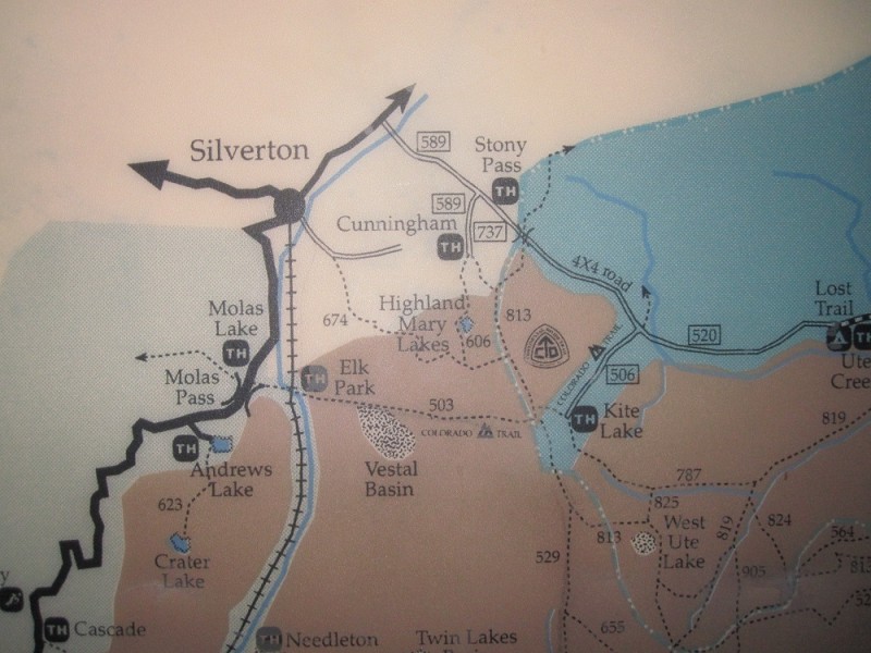
I started at the trailhead next to the Molas Lake Campground Park near Molas Pass. The trail is pretty straight forward. You will get on the Colorado Trail and take the turn off at the beaver ponds. If you look at the map below, you will notice that I didn't stay on the Colorado Trail and that I took the longer route in the beginning. I would recommend that you take the shorter route, which is the route I took during the hike back.
The hike begins super easy. You will drop over 1,600 feet in elevation. After crossing the river, the route is relatively flat to the beaver ponds. I crossed on the rocks to get to the other side of the ponds and found the trail to Vestal Basin.
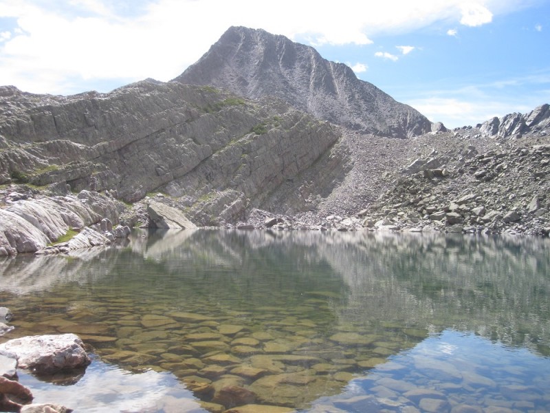
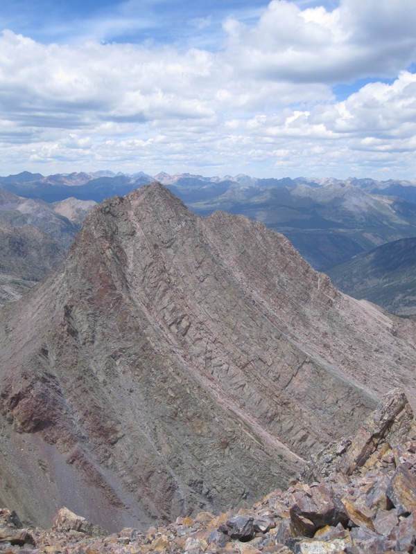
Once I got to the basin, I found a route up to Vestal Lake. I noticed on the return that some people were able to hike up to the lake at an earlier point in time. I thought I had noticed an earlier turn off but that trail was not too well defined. Check out strudolyubov's map in his trip report to see what I mean. The route I took up to the lake was relatively easy to follow. It really didn't matter that the route was a little longer because it led me closer to the lake where I was able to refill my water bottles. Also, Roach's classic route starts on the left side of Wham Ridge.
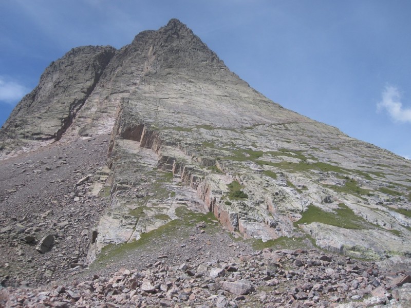
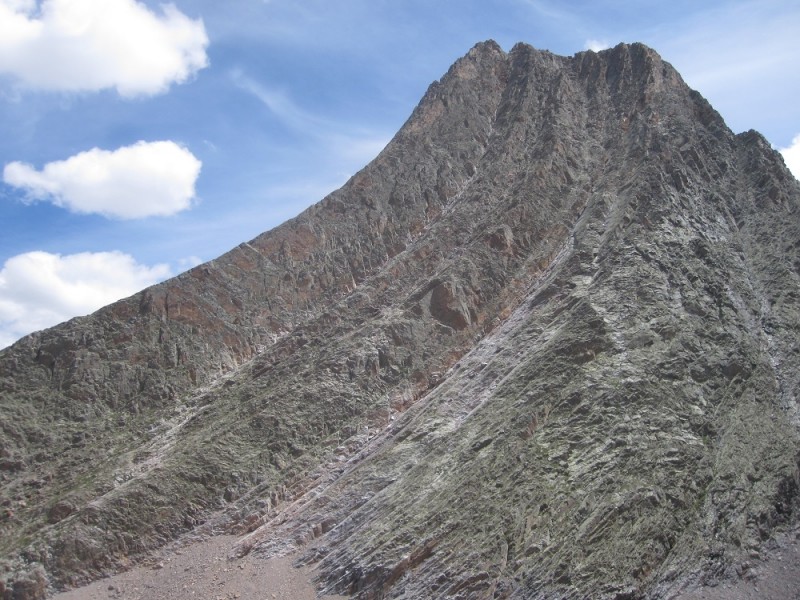
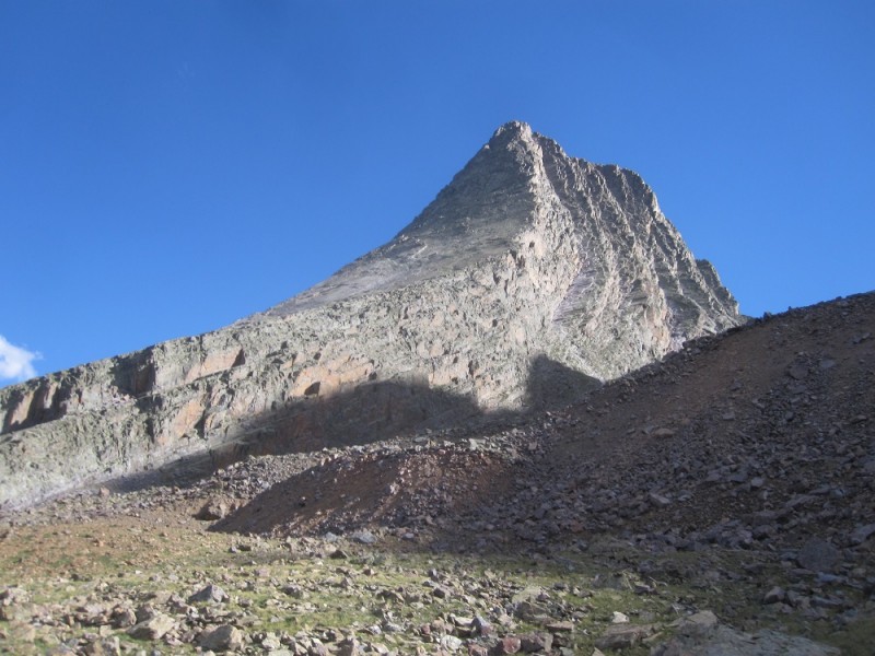
After a nice break, I started up Wham Ridge. Starting on the left side, I crossed to the right side on the highest patch of green. Near the right side, I climbed up two vertical cracks. I can't really tell you what the exposure was like because I told myself not to look down. There weren't any real benefits to looking down, so I resisted the temptation and keep my focus on the climb. For me, the climb wasn't too bad. I'm not exactly sure where the crux was, but I think I have an idea. To me, the crux wasn't much more difficult than other parts of the climb. Near the top, the rest of the climb had less exposure. I had thought it would be easier near the top, but to my surprise, there was still quite a bit of climbing left and route finding was required.
Finally, I made it to the summit! I was the only one on the summit! The weather was great (I would later learn during my trip that this was an aberration). It seemed that I was the only climber that day which was strange given the great weather.
After spending quite a bit of time on the summit, I headed down the back side. I recommend that when you head down, you stay in the same gully the entire time. You will know when it is time to head to the Vestal/Arrow saddle when you can see it. I tried to cut across to the saddle at an earlier point to see if there was a shortcut - there is none.
Once I got to the base of Vestal, I decided I couldn't pass up the opportunity to do Arrow with the weather being so great. How could I resist such a beautiful peak? However, I made the mistake of going up the wrong ledge. I had Roach's Arrow route printed out, but I thought I had found another decent route. This turned a class 3 climb to class 5. There was a point near the ridge that I had to bust out a move more difficult than anything I had to do on Vestal. I had to do a triple-take before I was able to pass that pitch. Eventually, I would make it to the summit!
After a long day, I started my hike back to the trailhead. The hike up to Molas Pass was slow and brutal! It was hell on earth regaining the 1,600 feet in elevation. The most difficult part was fighting back my sleepiness. My eyes just wanted to take a little rest...
I would eventually make it back to the car and pass out. It felt like a surreal experience given my drowsy state but mission accomplished! The hike ended up being my longest to date - by four hours. However, I would later beat this record during this trip by day hiking the four peaks in Chicago Basin to finish off the 14ers (will post soon).
Here are my times for reference:
- 4 hours to the beaver ponds
- 7 hours to Vestal Lake
- 9 hours to summit Vestal Peak
- 12 hours to summit Arrow Peak
- 19 hours to the car
You can download the .gpx below. I deleted the route up to Arrow because it's not the right route. If the link dies, you can PM for a copy. Thanks!
My GPS Tracks on Google Maps (made from a .GPX file upload):
I'm not sure if I would classify the hike back as good times but Vestal definitely was. You must have been the father & son combo I talked to in the basin? Glad you guys were able to get Vestal!
my bad; my assumption. ahh you were that mysterious voice behind me while I was talking to the two dudes. i could hear you, but I couldnt pin point your location :lol:
I was one of the guys setting up camp in the open meadow and we were a bit concerned you were hiking out so late. We guessed you wouldn't get to your car until around 11pm. Long day for you! But congratulations on getting those two amazing peaks.
Sam & I climbed Arrow up the far left ridge/left side of the wide gray ramp. This was the recommend route from Summit Lounger. Great route with solid rock. I never encountered Class 5 but Sam did.
Again...glad to see you made it safely out that night.
nkan02 - how did i miss your trip report? reading that before my hike would have been really helpful. i must have focused more on getting beta for vestal than arrow, which i wasn't sure if i was would have time to do.
it seems that near the top of the wrong ledge you headed right when i headed left? i thought it got pretty steep on the right side, so I decided on left to get to the ridge and go up that way.
i felt the wrong ledge was pretty damn solid at the lower end compared to the recommended ledge. on the descent, i was on the right route but i wanted to drop down to the lower ledge. i'm guessing there wasn't an easy way to cross over the different ledges near the top?
globreal - doing a long, return hike in the night was not on my to-do list that day :lol:
Just following some old links on SP.org and found this report (4 months later :? )
This was a great trip. Very cool that you were able to day-trip it. Brutal!
As Britt mentioned, we followed the Gray/Green rock to the far left of the ridge line on Arrow and found nothing but spectacular blocky 3rd/4th scrambling. I no-brained it off route a bit at one point and got myself into a bit of a pickle. Ended up on an exposed blank slab, working up an easy finger crack (guessing around 5.4/5.5 - think P1 on 1st Flatiron) for about 15-20 ft to get back onto the top of the 4th class blocks. Was definitely some of the spicier free climbing I've done. Grade was easy, but exposure was HUGE :shock:
We saw a pair of guys short-roping down the lower ”red rock” side of the ramp (they were up on top of the dihedral) and it didn't look like much fun. Much looser than anything we encountered.
Will ABSOLUTELY be heading back there for more climbing on those peaks. Would like the center route up Vestal's face next time.
I made the same mistake on Arrow - took the lower ledge. There were definitely some ”interesting” moves as you go higher. I had to backtrack a few times. Glad it went! uff. :lol:
Congrats on both peaks.
Caution: The information contained in this report may not be accurate and should not be the only resource used in preparation for your climb. Failure to have the necessary experience, physical conditioning, supplies or equipment can result in injury or death. 14ers.com and the author(s) of this report provide no warranties, either express or implied, that the information provided is accurate or reliable. By using the information provided, you agree to indemnify and hold harmless 14ers.com and the report author(s) with respect to any claims and demands against them, including any attorney fees and expenses. Please read the 14ers.com Safety and Disclaimer pages for more information.
Please respect private property: 14ers.com supports the rights of private landowners to determine how and by whom their land will be used. In Colorado, it is your responsibility to determine if land is private and to obtain the appropriate permission before entering the property.