| Report Type | Full |
| Peak(s) |
Blackwall Mountain - 13,077 feet |
| Date Posted | 07/09/2013 |
| Modified | 04/20/2017 |
| Date Climbed | 07/09/2013 |
| Author | Above+Beyond |
| Blackwall Mtn from Engineer Pass road / American Flats |
|---|
|
Quads: Handies Peak, Wetterhorn Peak I'd never think to post a trip report on an obscure, low-ranked peak such as Blackwall Mountain... except that when I got to the summit and located the makeshift mini-register -- a few tiny notepad sheets in a ziplock baggie -- I noticed the name MIKE GARRATT (in all caps just like that), dated July 2007. For those who don't know, he's the lead author along with Bob Martin of the illustrious guidebook Colorado's High Thirteeneers: A Climbing and Hiking Guide, my first edition (1984) copy of which was bought probably less than a year after it came out, and has subsequently been well used over the intervening 25+ years. So, crossing paths with a recognizable name such as that, even half a dozen years later, made this climb special. Blackwall Mountain lies deep in the heart of an untrailed region of the Uncompahgre Wilderness roughly halfway between Wetterhorn Peak and the 4WD Engineer Pass; it's 3 2/3 mi SW of the former and 3 3/4 mi N-NNE of the latter. It lies at the head of Cow Creek, a major tributary to the Uncompahgre River, which it joins N of Ridgway near the reservoir. The upper part of the drainage to the SE of there includes Wetterhorn Creek, Middle Canyon Creek, Cow Creek's main branch, Wildhorse Creek, and Difficulty Creek. Blackwall Mountain constitutes the high ground between the heads of the main branch of Cow Creek (to the E and S) and Wildhorse Creek (to the W). Other landmarks in its vicinity include Wildhorse Peak (13,266 ft; 1 1/4 mi SSW) and the striking monolith UN 12,968, which rises 700 ft from just ~1/3 mi S of the base of the climb. My route, from the S across American Flats, gives an upclose look at three sides of this big chunk of rock, as well as going by the S and E sides of Wildhorse Peak. I parked ~2/3 mi down the E side from the top of Engineer Pass (where the sign is). There are three things which mark the location of the trailhead:
This is where the official trailhead for the largely non-existent American Flats trail to the N takes off from, at an elevation of 12,380 ft. The trail takes off to the NW up the hill ~100 ft vertical out of the creek's drainage before angling N to the Wilderness Boundary sign (waypoint #1). There's an old jeep or wagon track running N across much of the W end of American Flats which is shown on the old 1955 Wetterhorn Peak topo quad, that is now mostly all overgrown and only visible as an often merely faint depression in the tundra. It is marked by occasional posts for at least half the way to a 12,300 ft saddle 0.8 mi S of Wildhorse Peak, 1 2/3 mi N of the trailhead. Indian paintbrush in American Flats. Looking N: Wildhorse Peak at center, Points 12,913 and 12,968 to its right; the location of waypoint #4 is on the rounded hump of tundra in front of and just to the right of Pt 12,913:  Along the way, a few hundred yards NW of waypoint #2, there's a little flat boggy/marshy area 1.0 mi NNW of the TH, at 12,420 ft, which is probably best crossed at its W (upper) end. The old track is shown on the quad going to the E (right) of this bog, and then contouring at the 12,340-380 ft level N-NNE ~2/3 mi to an intersection with the Bear Creek Trail coming up all the way over from the Million Dollar Highway above Ouray. I never did cross this trail or see any sign of it, even though I was trying to stay a little to the W of where the old jeep track was supposed to be. The only possibility was some sort of marker (cairn?) visible up on the ridge ~250 ft vertical above and to the W along in here. By trying to roughly contour north, I eventually got to a trail marker post near the 12,300 ft saddle (waypoint #3); the actual physical lowpoint is ~200 yds to the ENE. It's a little before here that you move onto the Wetterhorn Peak quad. It took an hour to get to this far. From here the route goes NE up ~300 ft vertical on the open tundra, following the Hinsdale/Ouray County boundary line to its most northern extreme in here, and then a little farther N, to waypoint #4. The approach then continues N and slightly E past the SE corner of Wildhorse Peak to a 12,620 ft saddle just to the peak's E (waypoint #5). You'll probably start to pick up short runs of game trails by this point. Looking NNE from near waypoint #4. The waypoint #6 saddle is at center, Pt 12,913 is at left (with the rock slide on its S slopes that the route crosses), and Wetterhorn Peak is at the far right:  The next short stretch is perhaps the most technically difficult part of this Class 2 hike, as one traverses ENE, climbing very slightly, across the steepish S slopes of Pt 12,913, which near a 30� angle according to the topo. (This is also what the angle of Wildhorse's S slopes work out as being.) Seemed like more... No biggie - it's more tedious/slow for ~10 minutes than hard. Anyway, and in particular, there's a rock slide which has to be crossed en route to a 12,660 ft second saddle (waypoint #6) to the E of Pt 12,913. It was another hour from the last trail marker post (waypoint #3) to here, and if you're like me you'll probably come out a little high of the saddle. By now the scenery is very alpinish, and with a trickle of running water nearby just to the N of Pt 12,913's lower E ridge when I was there, this made a good lunch break spot. Pt 12,968. Wetterhorn Peak is just to its left, Redcliff and Coxcomb Peak are at far left beyond Blackwall Mountain's SE flank, with Heisshorn Peak in between in the shade in the far distance:  It's then a short distance N down to the W side of the 12,540 ft tarn next to Pt 12,968. Continuing on N-NW and down one level there's a small basin 200+ ft vertical lower (waypoint #7), below Blackwall Mountain's hoodoo-lined SW ridge; an extensive one at left has a hole/arch in it when seen from farther E. One wants to angle right (E) from here, making a slightly descending traverse to clear the bottom of a rock slide area occupying the W side of the lower part of Blackwall Mountain's SSE face. The approach is (finally) over and the actual climb to the summit starts from here, at ~12,250 ft elevation. Waypoint #8 is just a little ways beyond and above this spot, which it took me 2 1/2+ hrs travel time to make. The only columbine I saw all day were in this area at the bottom of the rock slide. Even though it was early July, almost all the snow had melted off 3-4 weeks ago and it had been hot/dry ever since. Lots of the foliage on the tundra away from any running or remaining standing water was parched and near the wilting point; some was downright crunchy. The climb of only ~825 ft up to the summit is on steepish grass. The maximum slope on the topo map measures out at 27 1/2�. There's a shallow drainage (dry when I was there) in the center of the slope which one naturally follows up in places on some well-cemented rock steps and little terraces. Eventually you get to high on the SW ridge less than 200 ft below the top, near a little saddle or level spot on the ridge. 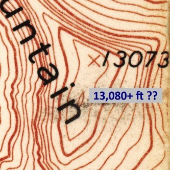 Even though the 1955 Wetterhorn Peak quad seems to indicate a second closed contour on the SW summit, indicating a height of at least 13,080 ft, while the official NE summit has the marked elevation of 13,073 ft, and thus causing some confusion, the SW summit is indeed about half a dozen feet lower: Looking SSW from Blackwall Mountain's summit, showing the SW sub-summit. Wildhorse Peak is at right, the location of Engineer Pass is at center, and the Grenadier Range is in the far distance at left:  Here are a few notable extracts from the summit panorama which follows... Looking NNE from Blackwall Mountain's summit. The extensive hoodoo landscape in the upper Cow Creek drainage (below), Coxcomb Peak at center above:  Looking SW from Blackwall Mountain's summit. Wildhorse Peak is at left, Rolling Mountain and Grizzly Peak B are in the distance at center, and Vermillion Peak (21 3/8 mi away) with its surrounding summits Fuller, Golden Horn, U.S. Grant, and Pilot Knob are visible at right. Lookout Peak just to the N of Ophir Pass is at farthest right:  Panorama looking S from Blackwall Mountain's summit. Handies Peak is in the distance at left, UN 13,688 B is at center, while the mountain at far right with the long flattish top is UN 13,722 to the NW of Cinnamon Pass. The tilted tundra mesa running across much of the picture is Dolly Varden Mountain. That's a high flying swallow at far left!  The return route just retraces the approach. I was really dragging most the way back, so it took more than an hour longer than the 2 1/2+ hrs going in did. The total roundtrip distance, measured waypoint to waypoint, is 7 2/3 mi. So this is a pretty long hike, all of it spent on untrailed terrain within +/-400 ft vertical of the 12,650 ft level. At about one mile per hour travel time, one should allow at least ~8 hrs -- plus snack, rest, and picture taking breaks. Stronger parties may be able to make better time and/or include a climb of Wildhorse Peak in the trip, but even alone Blackwall Mountain was a very full day for moi, but well worth it. With all the little ups and downs along the way added up, the total trip vertical footage calculates out to right at or just under 2000 ft. If you're going up there, don't expect to see anybody; according to the register, Blackwall is only climbed by two or three parties per year, like many of these obscure low-13ers. I was the first one up there this year. Take a small spice jar or other container with you, as the baggie's plastic was starting to deteriorate. I'll post my ten measured GPS waypoints when I figure out how to convert a .txt file to the .gpx format... In the meanwhile, maybe you can make use of this poor attempt at doing a table: 0) Trailhead ~2/3 mi down E of Engineer Pass............: 37-58-38 : 107-34-34 : 12,380 ft (guesstimated coords from topo) 1) Wilderness Bndry sign; ESE shoulder of Darley Mtn: 37-58-55 : 107-34-36 : 12,509 2) Marker post for old jeep/wagon track......................: 37-59-15 : 107-34-41 : 12,399 3) Marker sign for Horsethief Trail................................: 38-00-05 : 107-34-43 : 12,354 4) Extended S pt off base of Wildhorse's SE ridge.......: 38-00-28 : 107-34-26 : 12,601 5) Saddle just E of Wildhorse Peak..............................: 38-00-49 : 107-34-25 : 12,641 6) Saddle E of Pt 12,913..............................................: 38-00-57 : 107-34-02 : 12,667 7) Next level below 12,540 ft tarn...............................: 38-01-14 : 107-34-02 : 12,326 8) Base of Blackwall Mountain's SSE face.....................: 38-01-24 : 107-33-49 : 12,308 9) Higher on SSE face...................................................: 38-01-33 : 107-33-54 : 12,748 10) Summit of Blackwall Mountain................................: 38-01-43.6 : 107-33-53.0 : 13,095 (one measurement) . Thumbnails for uploaded photos (click to open slideshow): ")
")
")
")
")
")
")
")
|
| Comments or Questions | ||||||||||||
|---|---|---|---|---|---|---|---|---|---|---|---|---|
|
Caution: The information contained in this report may not be accurate and should not be the only resource used in preparation for your climb. Failure to have the necessary experience, physical conditioning, supplies or equipment can result in injury or death. 14ers.com and the author(s) of this report provide no warranties, either express or implied, that the information provided is accurate or reliable. By using the information provided, you agree to indemnify and hold harmless 14ers.com and the report author(s) with respect to any claims and demands against them, including any attorney fees and expenses. Please read the 14ers.com Safety and Disclaimer pages for more information.
Please respect private property: 14ers.com supports the rights of private landowners to determine how and by whom their land will be used. In Colorado, it is your responsibility to determine if land is private and to obtain the appropriate permission before entering the property.


