Download Agreement, Release, and Acknowledgement of Risk:
You (the person requesting this file download) fully understand mountain climbing ("Activity") involves risks and dangers of serious bodily injury, including permanent disability, paralysis, and death ("Risks") and you fully accept and assume all such risks and all responsibility for losses, costs, and damages you incur as a result of your participation in this Activity.
You acknowledge that information in the file you have chosen to download may not be accurate and may contain errors. You agree to assume all risks when using this information and agree to release and discharge 14ers.com, 14ers Inc. and the author(s) of such information (collectively, the "Released Parties").
You hereby discharge the Released Parties from all damages, actions, claims and liabilities of any nature, specifically including, but not limited to, damages, actions, claims and liabilities arising from or related to the negligence of the Released Parties. You further agree to indemnify, hold harmless and defend 14ers.com, 14ers Inc. and each of the other Released Parties from and against any loss, damage, liability and expense, including costs and attorney fees, incurred by 14ers.com, 14ers Inc. or any of the other Released Parties as a result of you using information provided on the 14ers.com or 14ers Inc. websites.
You have read this agreement, fully understand its terms and intend it to be a complete and unconditional release of all liability to the greatest extent allowed by law and agree that if any portion of this agreement is held to be invalid the balance, notwithstanding, shall continue in full force and effect.
By clicking "OK" you agree to these terms. If you DO NOT agree, click "Cancel"...
With several friends visiting the Lake City region for the San Juan Solstice 50miler, I took the opportunity to return to the Lake City region after a 5 year hiatus. It was also a good opportunity for me to put a good dent in my goal of finishing the 14ers this summer. After squeezing in a quick run/climb of Redcloud and Sunshine on Saturday (3h31min car to car) amidst cheering people on at the race, Sunday found me again up early, this time headed for Matterhorn Creek and Uncompahgre and Wetterhorn, two of Colorado's most aesthetic 14ers. I parked my Subaru at the bottom of Matterhorn Creek, not wanting to tempt fate and knowing the 1/2mile up the road should only take me 10min. The Matterhorn Creek trail was a beautifully smooth path, allowing me to slow jog my way uphill onto the Ridge Stock Drive trail. This led me to the saddle below Matterhorn (1h8min) and the long traverse over to Uncompahgre. Both Uncompahgre and Wetterhorn rise strikingly from the high plateau, their summits guarded by several sets of ominous cliffs, but making for a very picturesque scene. I chose to do Uncompahgre first while my legs had some good pop in them, thus finishing with the shorter downhill from Wetterhorn back to the car. Upper Matterhorn Creek and Matterhorn Peak. Snow free Uncompahgre ahead
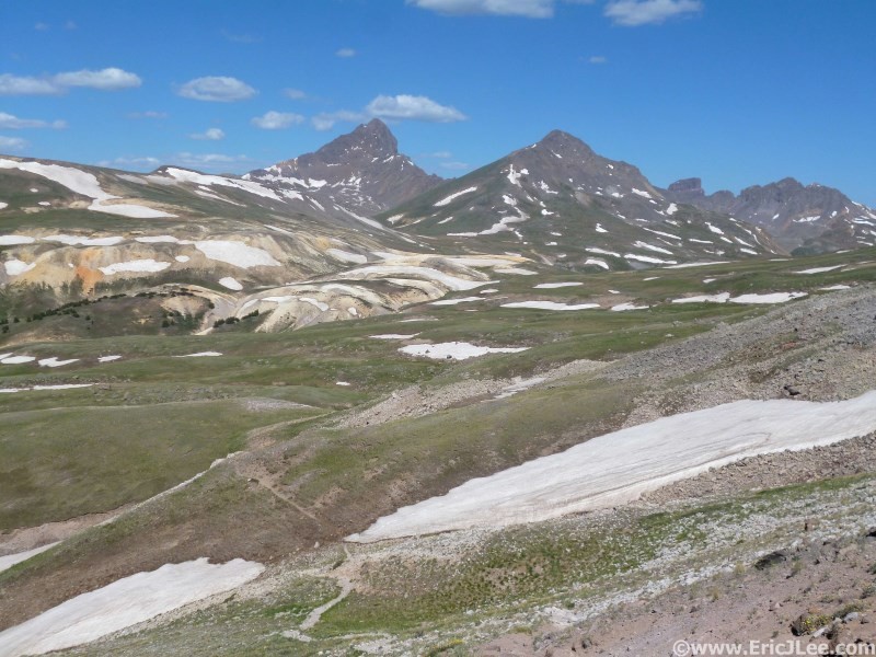
I was amazed at how smooth the trail across the high plateau then up Uncompahgre was, more like some nice forest single track than high alpine 14er running. I pushed a good pace, topping out on Uncompahgre 2h27min into my day, and took in the clear skies and the rare occasion of having one of Colorado's finest peaks completely to myself. I was able to blast down the smooth single track trail, making my way back over to the base of Matterhorn in an hour (3h28min). I had contemplated tossing in Matterhorn, but decided to leave it for another day, so from the Matterhorn saddle I took off following a faint use trail around the 12400ft contour. This eventually dropped me down to the creek at 12300ft where after a short uphill I was back on the main trail to Wetterhorn. High plateau traverse back to Matterhorn/Wetterhorn from the Nellie Creek Jct
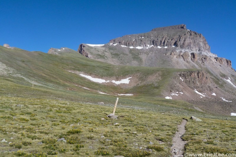
Wetterhorn is a much different peak, where Uncompahgre's cliffs are broken by a little rock hopping and a smooth trail, Wetterhorn tosses in a good deal of class 2-3 fun on the way to the summit. Right before the trail gets to the final ridgeline ascent of Wetterhorn, a soft lingering snowfield blocked travel, but is easily navigated either on scree to the left or by following the steps straight across. I picked my way up the initial ledges along the ridge to the rocky rib that blocks progress. By hugging right at the base of the rib I was able to locate the notch between the two large boulders that allows passage to the upper slopes of Wetterhorn. After a little easy terrain I navigated my way around the Ships Prow and to the base of the final obstacle below the summit. The class 3 scrambling to the summit of Wetterhorn was incredibly solid and very enjoyable, a nice break from the talus and scree of the day before. Final path to the ridgeline blocked by a little snow The Prow and the final class 3 section ahead
Before I knew it I was standing atop Wetterhorn (4h35min), admiring the open meadows of Matterhorn Creek on one side and the rocky knife edge ridge leading over to Matterhorn Peak on the other. After a brief break I quickly scrambled my way back down to the trail and cruised back to my car, making the descent in under an hour, for a solid 5h32min46sec car to car round trip time. Today's mountain run was one of the strongest I've had in a while; 17.8miles and 6700ft elevation gain, in a time that might be an FKT (Fastest Known Time) as I can't find any records online of anything faster. The time is soft; minus a few of the breaks I took one of the elite mountain runner can probably take 30-60min off the time fairly easily. The two mountains are a great set for trail running, as long as one doesn't mind a little class 2-3 fun near the summit of We
)web image link>
Thumbnails for uploaded photos (click to open slideshow):
I have been going to Lake City every summer for 35 out of my 39 years of existence. I'm about to make my 36th trip. I love the saying that God created Lake City and then he branched out. I have always dreamed of climbing Uncompahgre but have never done it, mainly for lack of experience. I live in Texas and don't get to practice.:) I'm just curious if you think this is a good first 14er to try. I climbed Tweto many years ago and did great. I am in pretty good shape but like I said just don't have much experience. Your thoughts?
tcorbett, I think Uncompahgre would be a fine first 14er, especially if you have a 4wd capable of getting up to the top of Nellie Creek Rd. From there its a nice hike on not too steep terrain. The only tricky part is a little class 2 rock hopping and a couple of big step ups that cover maybe 100ft of the route. It's a beautiful peak in a beautiful area. Also look at Handies for a first 14er, best of luck.
The 4wd won't be a problem. Thanks for the info! Maybe one day I can run up the mountain like you. Handies sounds like a great possibility too. (Biased opinions are allowed.) Where is the trailhead?
tcorbett, the Handies TH is either American Basin (standard) or Grizzly Gulch (longer). Both are accessed from outside Lake City past Lake San Cristobal. See the Trailheads links on 14ers for directions, you'll have no problem with either TH in a 4wd. Enjoy.
Last July I hiked both of these as my 1st and 2nd 14ers after driving from Texas (sea level) at age 54 and in no particular shape (pear shape?) at all. I was slow but I kept going and took a lot of breaks/pauses to let the heart slow back down some.
I also topped out on Antero but I drove almost to the top so that might not count for much.
I just climbed this one on 6/22 as my 2nd 14er and it was not too complicated at all...In fact, there was a 70(ish) year old woman and her daughter that we right behind us and she made it up with almost no problems! She had never climbed a 14er before, and I was very impressed by her!
I did this same route on the Fourth. This has to be one of THE BEST mountain runs out there! Everything is perfect on this one- from the rolling trail between the peaks to the fun class 3 to the top of Wetterhorn. My time was 5:29, however, I parked up higher at the trailhead proper. Congrats on a fast time and great line!
Caution: The information contained in this report may not be accurate and should not be the only resource used in preparation for your climb. Failure to have the necessary experience, physical conditioning, supplies or equipment can result in injury or death. 14ers.com and the author(s) of this report provide no warranties, either express or implied, that the information provided is accurate or reliable. By using the information provided, you agree to indemnify and hold harmless 14ers.com and the report author(s) with respect to any claims and demands against them, including any attorney fees and expenses. Please read the 14ers.com Safety and Disclaimer pages for more information.
Please respect private property: 14ers.com supports the rights of private landowners to determine how and by whom their land will be used. In Colorado, it is your responsibility to determine if land is private and to obtain the appropriate permission before entering the property.
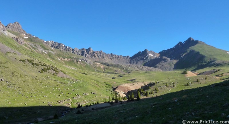

 Upper Matterhorn Creek and Matterhorn Peak.")
 Snow free Uncompahgre ahead")
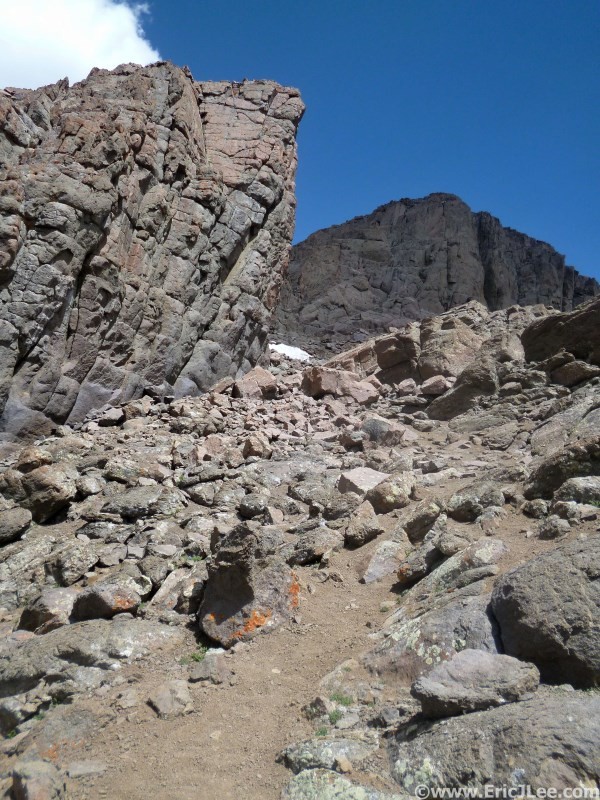
 A little easy rock hopping enroute to Uncompahgre.")
 High plateau traverse back to Matterhorn/Wetterhorn from the Nellie Creek Jct")
 Final path to the ridgeline blocked by a little snow")
 The Prow and the final class 3 section ahead")
 Class 3 staircase to the summit")
 Looking across the ridgeline to Matterhorn Peak with Uncompahgre in the background")