Download Agreement, Release, and Acknowledgement of Risk:
You (the person requesting this file download) fully understand mountain climbing ("Activity") involves risks and dangers of serious bodily injury, including permanent disability, paralysis, and death ("Risks") and you fully accept and assume all such risks and all responsibility for losses, costs, and damages you incur as a result of your participation in this Activity.
You acknowledge that information in the file you have chosen to download may not be accurate and may contain errors. You agree to assume all risks when using this information and agree to release and discharge 14ers.com, 14ers Inc. and the author(s) of such information (collectively, the "Released Parties").
You hereby discharge the Released Parties from all damages, actions, claims and liabilities of any nature, specifically including, but not limited to, damages, actions, claims and liabilities arising from or related to the negligence of the Released Parties. You further agree to indemnify, hold harmless and defend 14ers.com, 14ers Inc. and each of the other Released Parties from and against any loss, damage, liability and expense, including costs and attorney fees, incurred by 14ers.com, 14ers Inc. or any of the other Released Parties as a result of you using information provided on the 14ers.com or 14ers Inc. websites.
You have read this agreement, fully understand its terms and intend it to be a complete and unconditional release of all liability to the greatest extent allowed by law and agree that if any portion of this agreement is held to be invalid the balance, notwithstanding, shall continue in full force and effect.
By clicking "OK" you agree to these terms. If you DO NOT agree, click "Cancel"...
Start Time: 6:00 PM End Time: 8:30 PM Total Time: 2.5 hours Distance: 6 Miles Elevation Gain: 3900'
Pretty sweet road. Start in the desert and end right at treeline with great views of the valley most of the way.
I can see why this is one of the most difficult jeep roads but as a hiking trail it's a really enjoyable trek.
Notable is the river when you get to about 10,500' where you can fill up with water. Cool Cool.
Sunset over Como
6/6/2013: Little Bear Peak 14,037'
Start Time: 6:00 AM End Time: 11:30 PM Total Time: 5.5 hours Distance: 3.5 Miles Elevation Gain: 2300'
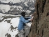
This is one seriously cool peak. We had bluebird weather: no wind, no clouds, and no other climbers the entire day. It was just Philip and I so we were able to go parallel up and down the hourglass and the remaining portion of the climb without the danger of rockfall to or from other climbers (we verified this frequently).
This was the mountain I was dreading ever since I made the mental decision to climb all the 14ers. After reading through threads titled "Which 14er do you fear the most?" and seeing Little Bear pop up quite frequently and hearing horror stories about the fear and adrenaline that pulses through a climber's veins while shaking nervously on the hourglass, I was convinced Little Bear would be an utter nightmare.
It is certainly evident that this mountain could produce all of the scary feelings people describe. We are really thankful to have climbed LB the day we did because it was essentially the best possible conditions (mostly the fact that there were no climbers above or below us) The climbing was rock solid and incredibly fun. The mountain had everything I loved about climbing. It also resolved some cognitive dissonance I had regarding my favorite peak. On an hourly basis my thoughts would sway from Longs Peak to the Crestones back down to the San Juans, then up to the Maroon Bells, but now I will have this peak firmly solidified in my mind as the epitome of perfection:
*Awesome hike in
*Awesome peak
*Awesome campsite
*AWESOME COMPANY (Thanks Philip)
Oh, and did I mention I had a terrible head cold the entire time? Yeah, I did. This was a nasty one that normally would have put me grasping for my phone to call in sick, but after suffering from and (still) recovering from 4 years of engineering school, climbing Little Bear with a debilitating sinus infection and sore throat was not too hard.
Did I mention this peak has amazing climbing, stellar views and is an incredible mountain? Don't believe me? I'll just have to show ya:
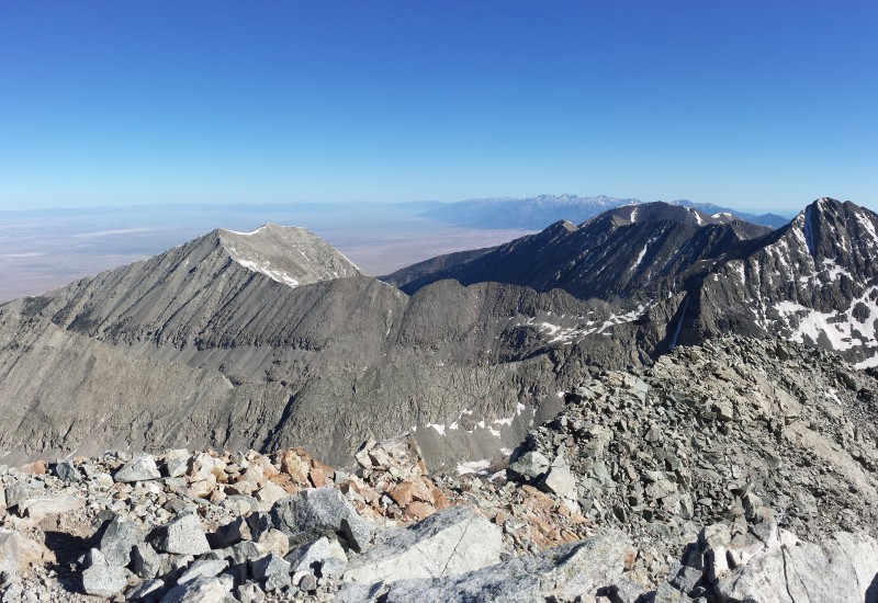
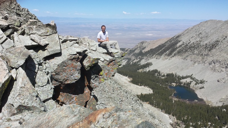
Philip and the Bear Loving every minute of it! Hourglass Looking West from LB summit Looking North from LB summit Looking East from LB summit Looking South from LB summit Philip on his perch
6/7/2013: Blanca Peak 14,345' and Ellingwood Point 14,042'
Start Time: 6:20 AM End Time: 12:20 PM Total Time: 6 hours Distance: 6 Miles Elevation Gain: 3000'
This was a pretty cool hike too! Hiking farther up the basin is spectacular, and looking back on the bear was a pretty great way to start the day. From the ridge to Blanca sure is cool, there is a bit of exposure to the East and a great view along the way as well.
We highly recommend the traverse!! It is reminiscent of the "Sawtooth" on Evans, but far more spectacular and magical. The trail is actually incredibly well cairned and easy to follow, you'll get over to Ellingwood in no time if you take this route!
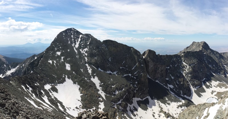
Basin Philip and Crater Lake Looking West from Blanca Summit Looking North from Blanca Summit Looking South from Blanca Summit Philip on Ellingwood Summit Check out that ultra prom!
Last but not least it's worth mentioning that the trip was not concluded until we were back in Golden eating at Woody's, capitalizing highly on the all-you-can eat buffet!
A trip report is fully inadequate to describe how incredible this mountain range is! Like the route description says, save yourself some fear and go on a less crowded weekday.
Thumbnails for uploaded photos (click to open slideshow):
Thanks for posting, glad you overcame your concerns and had a good time on LB. And the pics were good and will be useful, we're going to be up there next week. Thanks!
-Tom
I too have had LB on my radar with similar thoughts, and I've done Blanca, LB and 36 others so appreciated reading your feedbaxck. (I've read Gerry Roach's comments) Is the start to LB easy to find, wish I had looked but I don't remember seeing its start off lake como. Can you describe where the start is relative to lake como, THANKS!
Thanks for the report. I see a rope in one of your pictures in the hourglass. Did you fix that rope or was it already there? The route description says sometimes there's a rope and sometimes there isn't. Also, did you find yourself using it often?
I am going to hike in on Saturday (6/15) and this TR is most helpful. We plan on doing the traverse. I have the same question as others....Crampons? Ice axe?
GerryBear:
The start is pretty easy to find. Just hike up the road after lake como until it goes out of the trees and you are hiking alongside a creek. Look for the gully from the pictures, then cross the creek and start climbing up the gully. Everything else is cairned or self-evident.
cszakhem:
I didn't fix the rope nor did I use it. If you need one you must fix it yourself because you never know how long one has been there before and it may be broken.
larryrn / zombiewolf:
We didn't use crampons or an ice axe or microspikes. I'm glad I didn't lug the extra weight although I would recommend microspikes. Waterproof boots for sure.
Way to overcome the 14er fear fest. LB's a blast, provided nobody's above or below you.
The more popular a peak is, the harder it is to gauge its difficulty/danger and how your skills match up. I think Pyramid was my first realization that all those dreaded, terrible peaks might not be as bad as the internet communal mongering suggests.
Caution: The information contained in this report may not be accurate and should not be the only resource used in preparation for your climb. Failure to have the necessary experience, physical conditioning, supplies or equipment can result in injury or death. 14ers.com and the author(s) of this report provide no warranties, either express or implied, that the information provided is accurate or reliable. By using the information provided, you agree to indemnify and hold harmless 14ers.com and the report author(s) with respect to any claims and demands against them, including any attorney fees and expenses. Please read the 14ers.com Safety and Disclaimer pages for more information.
Please respect private property: 14ers.com supports the rights of private landowners to determine how and by whom their land will be used. In Colorado, it is your responsibility to determine if land is private and to obtain the appropriate permission before entering the property.


 Sunset over Como")
 Philip and the Bear")
 Loving every minute of it!")
 Hourglass")
 Looking West from LB summit")
 Looking North from LB summit")
 Looking East from LB summit")
 Looking South from LB summit")
 Philip on his perch")
 Basin")
 Philip and Crater Lake")
 Looking West from Blanca Summit")
 Looking North from Blanca Summit")
 Looking South from Blanca Summit")
 Philip on Ellingwood Summit")
 Check out that ultra prom!")